Discover Cabeceiras de BastoFree independent guide
ViveCabeceirasYOUR GUIDE TO CABECEIRAS
ENEnglish
SearchSaved

Stories of Cabeceiras

Choose a story to start with. You can change the subject or fine tune the search.

106 stories · All themes · Search: rios

Life you do not always see

Knowing animals begins by perceiving the territory and respecting the distance.

Choose a story · 24
Occurrence mentioned in the environmental document

The riverbed is a home too

Freshwater mussels depend on more than surface water.

Read here and view sources

The municipal environmental document mentions Margaritifera margaritifera in the municipality. The ICNF profile explains why the riverbed matters: young mussels live buried in the substrate and need oxygen. The species prefers flowing water and avoids conditions poor in oxygen.

It feeds by filtering particles from the water. Protecting this life means considering the riverbed, the water and the fish involved in reproduction. The municipal reference does not identify a current observation point.

There is a difference between having water and having the habitat this animal needs. The profile distinguishes flowing from still water and describes how river alteration and habitat fragmentation can harm the species. Filtering particles for food does not make the mussel resistant to pollution: oxygen availability and riverbed conditions remain essential.

Words in this story: see explanations →
Source and context

PDM — Environmental Assessment, p. 50
Accessed:

ICNF — Margaritifera margaritifera, ecology, reproduction and threats, pp. 2–3
Accessed:

Editorial summary; the date of consultation is not the date of the facts.
Santa Senhorinha · fauna mentioned in 1758

Trout, nase and chub in the river’s memory

Fish names were written into local history too.

Read here and view sources

In the memory of Santa Senhorinha of 1758, the abbot mentions trouts, echelons and bogas in the river he describes. The text combines observation of water and appreciation of fish as food. These common names are a historical clue: they do not accurately identify all species or prove their current presence. The old reference to fishing also does not define today's rules.

Source and context

Municipality — Memória de Santa Senhorinha, 23/05/1758; transcript of José Viriato Chapel (2003)

Accessed: . Editorial summary; the date of consultation is not the date of the facts.

Cavez · record from 2016–2017 and general biology

Not every river fish came from here

The pumpkinseed tells a story of introduction.

Explore: The same river, different ways of living →
Read here and view sources

Sunshine, Lepomis gibbosus, is originally from North America. The Interpretation Center of the River of Águeda describes it as an exotic species, of high body and flattened laterally, which lives in still waters but also in rivers. In breeding season, males may hinder access by juveniles of native species to the shore shelters. It was registered in Cavez in 2016–2017; this record does not measure its local impact.

The bluish bands from the head to the flanks and a dark spot on the tip of the pearl are part of the description. In juveniles, the pattern is simpler, on a greenish or olivaceous background. Age also changes appearance.

The menu includes insects, crustaceans, sea snails, and fish larvae. This diversity helps to realize that food is not limited to a single prey. The chart also distinguishes lentic environments, such as albufeiras, from exotic environments, such as rivers and streams: the species can use both. The geographical origin, presence in a survey and the effect on other species are different information.

Words in this story: see explanations →
Source and context

Águeda River Interpretation Center — Sun Loss
Accessed:

Biosphere / Iberdrola, APA file — Monitoring of ichthyofauna 2016–2017, February 2018; pp. 5, 35 and 40, station record 22 on p. 175 PDF
Accessed:

Editorial summary; the date of consultation is not the date of the facts.

General ecology · how a river is studied

River life tells a story too

Looking at water clarity is not enough.

Includes an activity to try →Explore: Read the river through different lanes →
Read here and view sources

To study a river, it is interesting to know which organisms live in it and in what abundance. The Portuguese Environment Agency includes benthic invertebrates among the elements used in biological evaluation, together with other groups, such as fish and plants.

The evaluation also considers chemical, physicochemical and hydromorphological aspects. It is necessary to combine observations, sampling and analysis: transparent water or a single animal is not enough to classify a river. This explanation does not attribute a current state to watercourses of Cabeceiras.

Words in this story: see explanations →
Source and context

APA — Rivers and albufeiras: benthic invertebrates and biological evaluation

APA — Environmental State Report: Water status assessment

Accessed: . Editorial summary; the date of consultation is not the date of the facts.

Rio Douro · an account of fauna from 1758

Fish in an old portrait

Trout and other freshwater fish appear in Rio Douro’s historical accounts.

Read here and view sources

Trout, bogas and escalos are the fish names recorded by the vicar of Rio Douro in 1758. He describes trout as the most numerous and distinguishes winter from summer fishing. These are impressions from the account, without counts that would allow abundance to be measured.

The testimony connects fauna with water use and village life. Old common names do not amount to complete scientific identifications; the practices described do not establish today’s fishing rules either.

Getting to know the parish
Source and context

Municipality of Cabeceiras de Basto — Parish memories of 1758: Rio Douro

Accessed: . Editorial summary; the date of consultation is not the date of the facts.

Cavez · record from 2016–2017 and general biology

A fish can migrate without going to sea

The common barbel makes its journey within the river.

Explore: The same river, different ways of living →
Read here and view sources

The Mora Fluviary describes the breeding migration of the common barb, Luciobarbus bocagei, to shallow and well-oxygenated waters, on sand, gravel or gravel. It is a trip in fresh water. It feeds on small animals from the bottom, plant matter and debris. The barb was registered in Cavez in the 2016–2017 campaign; the description of its behavior is general biology, not a migration observed at this point.

The trip does not contradict the preference for areas of weaker current and moderate temperature. The place used to live and feed may differ from the one chosen for reproduction. The Fluviary file places the latter between May and June, as a general description of the species.

The barbo is omnivorous: besides the invertebrates of the bottom and vegetable matter, it can occasionally eat small fish. The same source says it can reach about one meter. It is a possible dimension of the species, not the size measured in the specimens of Cavez.

Words in this story: see explanations →
Source and context

Mora Fluviary — Barbo-common, biology of the species
Accessed:

Biosphere / Iberdrola, APA file — Monitoring of ichthyofauna 2016–2017, February 2018; pp. 5, 35 and 40, station record 22 on p. 175 PDF
Accessed:

Editorial summary; the date of consultation is not the date of the facts.

Cavez · record from 2016–2017 and general biology

A small fish, many tiny prey

The gudgeon links river life with invertebrates.

Read here and view sources

The Gaia Biological Park describes Gobio lozanoi as a freshwater river fish that feeds on small invertebrates and usually measures about 12 centimeters. It is a usual dimension indicated in this chart, not the size of all individuals nor a measure collected in Cabeceiras.

In the survey of Cavez of 2016–2017, the gobium is among the six registered species. Adding this evidence to the description of the feed helps to ask a question about the river: which small animals support the fish? The record does not identify the prey consumed at that point or prove a relationship with each insect presented on this site.

Source and context

Gaia Biological Park — Gobio, Gobio lozanoi: habitat, food and size
Accessed:

Biosphere / Iberdrola, APA file — Monitoring of ichthyofauna 2016–2017, February 2018; pp. 5, 35 and 40, station record 22 on p. 175 PDF
Accessed:

Editorial summary; the date of consultation is not the date of the facts.

Serra da Cabreira · regional reference and species biology

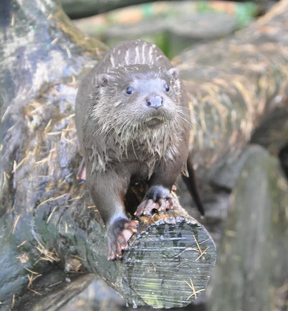
The otter wears its diving suit

Otter front view over wood, with snout, mustaches and visible paws.
European otter at the Lüneburg Heath fauna park, Germany, in 2009. Animal in fauna park; it is not a record of Cabeceiras.
Photography: Quartl · CC BY-SA 3.0
About this photograph

Date given at source: . Source consulted in 2026-11-07. EXIF orientation, proportional resizing and WebP conversion of the current version in Commons; no retouching or additional clipping.

Request removal or correct the photo credit

Waterproof fur and feet that help it swim.

Includes an activity to try →Explore: Body and environment →
Read here and view sources

The European otter, Lutra lutra, has membranes between its fingers and a thick coat that protects it in the water. Its life connects the river to its banks: vegetation offers shelter and roots can hide burrows. It is mainly active at dusk and at night.

The municipal portal of Vieira do Minho includes the otter among the mammals of the Cabreira. This regional reference allows to know the species, but does not indicate a spot of sighting.

The description of the University of Évora also refers to the long tail, tapered at the tip, and the snout with long mustaches. The otter does not depend only on rivers: the species also uses albufeiras, estuaries and, less often, the sea coast. These characteristics help to know the animal without converting the reading into a spot.

Source and context

University of Évora — Virtual Museum of Biodiversity, Lutra lutra; David Germano
Consultations: ,

Vieira Tourism of Minho — fauna of Serra da Cabreira, regional reference
Accessed:

Editorial summary; the date of consultation is not the date of the facts.

Species biology · documentary reference in the municipality

A mussel begins by travelling with a fish

Two lives connected beneath the surface.

Includes an activity to try →Explore: The mussel ride with the fish →
Read here and view sources

The larvae of Margaritifera margaritifera, called glochidia, attach themselves to the gills of salmonids such as trout. The fish acts as a host and carries them while they develop.

After their transformation, they detach and settle on the bottom. Success at this stage also depends on where they land: dispersal and finding conditions for survival are different things. The diagram summarises general biology, not reproduction observed in the municipality.

This journey does not immediately produce an adult capable of reproducing. The ICNF profile places sexual maturity between seven and twenty years and describes a long lifespan. These are general values from that source, not ages measured in specimens from Cabeceiras. The presence of adults and the arrival of new generations are therefore different questions when studying a population.

Words in this story: see explanations →
Source and context

ICNF — Margaritifera margaritifera, ecology, reproduction and threats, pp. 2–3
Accessed:

PDM — Environmental Assessment, p. 50
Accessed:

Editorial summary; the date of consultation is not the date of the facts.

Cavez · monitoring in 2016–2017

Six species beneath the surface

A sampling survey offers a small portrait of the Tâmega at Cavez.

Includes an activity to try →Explore: You know the six fish from the lift →
Read here and view sources

At station 22, the 2016–2017 report recorded six fish: barbo-comum, boga-do-Norte, escalo-do-Norte, bordalo, góbio and perca-sol, using their Portuguese common names. The station profile places it in Cavez. These results document that survey; they are neither a current inventory nor directions to fishing spots.

The six names open six ways of looking at the river. The barbel leads to migration within fresh water; the nase to differences between young and adult fish; the chub to scale patterns. The bordalo and gudgeon help explore diet. The pumpkinseed introduces geographical origin. Open the cards to choose a clue and reach the species explanation.

Sampling surveys and biological profiles serve different purposes. The survey documents fish recorded at that place and time. The profiles explain general species characteristics, without demonstrating that all these behaviours were observed in Cavez. Read both together while keeping that distinction.

Getting to know the parish
Source and context

Biosphere / Iberdrola, APA file — Monitoring of ichthyofauna 2016–2017, February 2018; pp. 5, 35 and 40, station record 22 on p. 175 PDF
Accessed:

Mora Fluviary — Barbo-common, biology of the species
Accessed:

Municipality of Santa Maria da Feira — Northern Boga, fauna catalogue
Accessed:

Arouca Geopark — Northern scale, Squalius carolitertii: description and biology
Accessed:

ICNF — embroidery, ecology and riverside vegetation, pp. 2–3 (bibliography up to 2005)
Accessed:

Gaia Biological Park — Gobio, Gobio lozanoi: habitat, food and size
Accessed:

Águeda River Interpretation Center — Sun Loss
Accessed:

Editorial summary; the date of consultation is not the date of the facts.

Species biology · with a local record

A small bird that dives

The white-throated dipper brings birdwatching into the current.

Includes an activity to try →Explore: The stream is more than water →
Read here and view sources

A compact body, short tail and white breast in adults offer clues to Cinclus cinclus, the white-throated dipper. This bird can dive and is associated with fast-flowing streams, especially in mountains. The gallery includes a local record; the photograph shows the bird in a hand, not the diving behaviour described here. Aves de Portugal describes fast, direct flight and classifies the species as resident: it may remain in breeding areas throughout the year. That general trait does not confirm a continuous presence at the local record’s location.

Underwater, the food it seeks includes small invertebrates. The BTO describes the bird entering the current from rocks or flying low to another perch. The stream is therefore a feeding space, not simply a backdrop where the bird appears.

Age also changes its appearance: juveniles are greyer and more mottled than white-breasted adults. This biological comparison does not assign an age to the photographed bird. A record shows an encounter; understanding what a species does requires bringing together other observations and sources.

Words in this story: see explanations →
Source and context

Birds of Portugal — Watermelon, identification, habits and distribution

British Trust for Ornithology — BirdFacts: Dipper, Cinclus cinclus

Accessed: . Editorial summary; the date of consultation is not the date of the facts.

Species biology · record in Rio Douro

A small frog with a strong connection to water

Some lives depend on the bank as much as the stream.

Includes an activity to try →Explore: One photograph opens other questions →
Read here and view sources

The Iberian frog naturally lives in the Iberian Peninsula: that is what it means to be endemic to this territory. With a slender body and pointed snout, it can reach about 5.5 centimetres. Reproduction takes place in water, and the species prefers mountain streams with vegetation along the banks and rocky beds.

The photograph recorded in Rio Douro opens a window onto this discreet life. On its own, it does not demonstrate water quality: pollution and changes to riverside habitats are among the threats described by the University of Évora.

The description also highlights a dark stripe crossing the eye area, with a narrower pale stripe beneath. These are details to appreciate in a photograph without handling the animal.

Source and context

University of Évora — Virtual Museum of Biodiversity

Accessed: . Editorial summary; the date of consultation is not the date of the facts.

Serra da Cabreira · regional reference and species biology

A desman’s life in the current

Cold water has its own inhabitants too.

Explore: The river is also a pantry →
Read here and view sources

The water mole, Galemys pyrenaicus, is associated with cold, clear and well-oxygenated waters, often in rapid mountain rivers. The University of Évora also refers to the use of slower waters, such as canals and lakes: preference is not exclusive. Its natural distribution is limited to the Iberian Peninsula and the Pyrenees. In conservation, there are vegetation margins, shelters and habitat continuity; the chart identifies silting and isolation between threats. The municipal description of the fauna of Cabreira mentions the species, but this reading does not have a geolocalized register in the municipality.

The prolonged snout in a small trunk helps to search for larvae of invertebrates underwater, according to the description of the Generalitat of Catalonia. The technical file housed by ICNF highlights the invertebrates from the bottom of the river as a food base, including groups of tricopters, plecopters, ephemeropters and dipteres. The small animals that look like details of the river are part of the feeding of a mammal.

The profile of the ICNF presents a caveat for Portugal: it considers unfavourable the habitats of standing water, such as albufeiras and small lagoons of altitude. We should not turn the general reference to slow waters into an invitation to search for the species in any lake. Adequate habitat also involves food, shelters on the banks and connection to other sections of the river.

Words in this story: see explanations →
Source and context

University of Évora — Virtual Museum of Biodiversity, Galemys pyrenaicus

Vieira Tourism of Minho — fauna of Serra da Cabreira, regional reference

ICNF — Galemys pyrenaicus, ecology and nutrition (historical references)

Generalitat de Catalunya — Iberian Desmán, description of snout and feeding

Accessed: . Editorial summary; the date of consultation is not the date of the facts.

Cavez · record from 2016–2017 and general biology

A preferred current changes with age

For a young nase, a calm stretch can make a difference.

Explore: The same river, different ways of living →
Read here and view sources

The Northern boga, Pseudochondrostoma duriense, is a species of the Iberian Peninsula. Santa Maria da Feira's municipal record describes adults in sections of strong current and juveniles that prefer waters of lower current and thin backgrounds. It also refers to upstream movements before reproduction. The Cavez record of 2016–2017 confirms the species in that sample; it does not describe the age or behavior of the specimens.

There is a clue in the mouth: the lower lip is right and has a well developed corneal blade. The body may have small dark spots. These features complement the history of the habitat; they do not replace a careful identification of the fish.

The municipal source places migrations upstream between March and June and indicates an approximate longevity of six years. Amount means moving towards the spring. The calendar and life span describe the species in general, without dating a shift or determining the age of the fish sampled at Tâmega.

Words in this story: see explanations →
Source and context

Municipality of Santa Maria da Feira — Northern Boga, fauna catalogue
Accessed:

Biosphere / Iberdrola, APA file — Monitoring of ichthyofauna 2016–2017, February 2018; pp. 5, 35 and 40, station record 22 on p. 175 PDF
Accessed:

Editorial summary; the date of consultation is not the date of the facts.

Cavez · record from 2016–2017 and general biology

A fish’s menu can include insects

Feeding connects life in and out of the water.

Includes an activity to try →Explore: Who feeds on what? →
Read here and view sources

The chart of the ICNF describes the embroidery, complex Squalius alburnoids, as a consumer mainly of insect larvae. In summer and early autumn, it refers to higher consumption of terrestrial insects. It is a small link between the river and its margins. The embroidery appears in the study of Cavez of 2016–2017 under the name Iberocypris alburnoides; the local study did not analyze this seasonal change in feeding.

The same chart describes the use of rivers and streams with diverse characteristics, including small and shallow courses with emerging aquatic vegetation. The habitat is not only water: shelters, vegetation and alternation of zones with different current speeds enter history.

Therefore, a margin totally devoid of vegetation changes more than the view. The chart associates the loss of riverside vegetation with the reduction of shade, shelter and feeding sites. These general ecological relationships help to interpret the river; they are not a current evaluation of a section of Cavez. The local record of 2016–2017 and the biological explanation answer different questions: where the fish was documented and how it relates to the environment.

Source and context

ICNF — embroidery, ecology and riverside vegetation, pp. 2–3 (bibliography up to 2005)
Accessed:

Biosphere / Iberdrola, APA file — Monitoring of ichthyofauna 2016–2017, February 2018; pp. 5, 35 and 40, station record 22 on p. 175 PDF
Accessed:

Editorial summary; the date of consultation is not the date of the facts.

Amphibians · general biology

Skin that breathes too

In amphibians, skin does more than cover the body.

Explore: From body to environment →
Read here and view sources

The naked and permeable skin of amphibians participates in breathing. The Vasco da Gama Aquarium explains that respiratory changes can also involve gills and lungs, according to the phase of life. This permeability helps to perceive the sensitivity of these animals to changes in the environment. It is general biology to better know the frogs, salamanders and newts presented in this collection.

Body temperature follows the conditions of the environment: they are ectothermal animals. This characteristic is different from the permeability of the skin, although both help to understand the relationship with the place where they live. It is also not enough to protect only water: many species use terrestrial environments in other stages of life.

Words in this story: see explanations →
Source and context

Vasco da Gama Aquarium — Thematic Sheets: Amphibians, 2th cycle, pp. 1–2

Accessed: . Editorial summary; the date of consultation is not the date of the facts.

General biology · dragonflies and damselflies, without a confirmed local record

Resting wings offer a clue

Dragonflies and damselflies do not rest in the same way.

Includes an activity to try →Explore: Wings, water and food →
Read here and view sources

The Tagis guide describes dragonflies with two pairs of similar wings, usually closed or slightly open vertically when they land. Dragonflies keep them open horizontally. It is a first observation clue, not a species identification. Dragonflies adults can move away from the watercourses thanks to their flight capacity.

Both groups belong to the Odonata order. The guide highlights the compound eyes, the short antennas and jaws used to capture other animals. Among the prey are flies and mosquitoes: these wings are part of a history of predators, not just colors.

Connection to water also changes with the phase of life. Dragonflies need it to complete the cycle, but adults can hunt in sunny clearings, far from the river where they were born. Seeing an adult on a path does not allow them to locate their breeding point. Compare the position of the wings, behavior and environment without turning an isolated clue into an identification.

Source and context

Tagis — Insects in Order, Odonata, dragonflies, dragonflies and friganiums (pp. 39–43 and 74)

Accessed: . Editorial summary; the date of consultation is not the date of the facts.

General biology · aquatic insects, without a local species inventory

Tiny shelters beneath the water

Some larvae use sand and plant fragments.

Includes an activity to try →
Read here and view sources

The larvae of the friganiums, or tricopters, live in the water; many build shelters with sand or vegetable fragments. They integrate the food chains of rivers and streams, serving as food for fish, birds and amphibians. Tagis' guide highlights its usefulness as ecological indicators. Finding a copy, however, does not alone certify the quality of the water.

The underwater shelter is only a part of the story. The adult has hair-covered wings, thin antennas and when he lands, he has wings like a small roof over the body. He may remember a butterfly, but these have scales on the wings. The adult friganiums usually fly at nightfall and live near fresh water masses.

Nor does there exist a single menu for all larvae: according to the group, they can consume algae, plants, organic remains or other invertebrates. They are consumers and, at the same time, food from other animals. A food network better describes these relationships than a row with only one food for each species.

Words in this story: see explanations →
Source and context

Tagis — Insects in Order, Odonata, dragonflies, dragonflies and friganiums (pp. 39–43 and 74)

Accessed: . Editorial summary; the date of consultation is not the date of the facts.

Soil life · general ecology

Beneath our feet, a world of mixtures

Soil contains water and air too.

Includes an activity to try →Explore: From the ground to the water, follow the connections →
Read here and view sources

The ground is not a compact block: mineral particles and organic matter share space with water, air and organisms. The rock, climate and living beings participate in the formation of the soil.

Looking only at the surface leaves much life undiscovered. This explanation helps to explore gardens and forests, but does not replace a soil analysis of Cabeceiras.

Life is not distributed equally. FAO describes areas of intense activity near the roots, where plant remains accumulate and on the walls of earthworm galleries. The immediate vicinity of a root has a name: rhizosphere. Thinking about these small areas helps to understand why two portions of nearby land can offer different conditions to organisms.

There are inhabitants that we will hardly see on a walk. Bacteria participate in the transformation of organic matter; some are associated with roots and contribute to nitrogen fixation. Fungi also decompose remains and can establish relationships with plants. Not all do the same work: the soil gathers activities that intersect, from the food to the transformation of materials.

A cover of leaves is not only a finish of the forest. It is a matter that can feed this community. In the interview published by Gulbenkian, researchers recommend keeping part of the dead blanket in green spaces and avoiding often moving the soil in depth. They are general conservation guidelines, not an evaluation or recipe for each land of the municipality.

Words in this story: see explanations →
Source and context

Calouste Gulbenkian Foundation / Wilder — Cristina Cruz, Teresa Dias and Silvana Munzi (FCUL), 26/03/2024

FAO — What is soil biodiversity?

Accessed: . Editorial summary; the date of consultation is not the date of the facts.

Rio Douro · animals mentioned in 1758

Animals remembered in the mountains

A list from 1758 combines encounters, abundance and passing visitors.

Read here and view sources

The vicar of Rio Douro names rabbits, hares, partridges, wolves, foxes and badgers when describing the mountains in 1758. Adds mountain pigs of passage and places the partridges only in some parts. These language differences are part of the testimony and deserve to be preserved.

The report describes cold, windy and snowy mountains in winter. It brings animals and landscape closer, but does not present counts, observation methods or a scientific inventory. It does not allow to conclude that all the mentioned species continue in the same places today.

Source and context

Municipality — Parish Memoirs of Rio Douro, António Carneiro da Costa, 22/05/1758

Accessed: . Editorial summary; the date of consultation is not the date of the facts.

Reptiles · general biology, without a confirmed local record in this profile

One snake can have different patterns

Snake with the body wavy to the surface of the water, between blue reflexes and small ripples.
Viperine water snake swimming in Extremadura, Spain, in 2022. Illustration of the species; not a record of Cabeceiras.
Photography: Charles J. Sharp · CC BY-SA 4.0
About this photograph

Date given at source: . Source consulted in 2026-11-07. EXIF orientation, proportional resize and WebP conversion; no retouching or new clipping of file obtained in Commons.

Request removal or correct the photo credit

The viperine snake’s back does not always have the same pattern.

Includes an activity to try →Explore: The same environment, different ways of life →
Read here and view sources

Natrix maura may present a zigzag stripe, but also a pattern of two clear longitudinal lines. The Spanish biodiversity inventory still describes variation in body tones. A single design does not summarize all individuals of the species.

The chart of the Northern Coastal Natural Park explains the connection to rivers, ponds, streams and other aquatic environments, without excluding displacements on land. It is a general context about the species: it is not an observation in Cabeceiras. Reading compares variation and habitat; it is not a key to identifying snakes found in the field.

The Charcos com Vida project describes a feed mainly in water: invertebrates, larvae and adults of amphibians and small fish enter the menu. The aquatic environment is, thus, a feeding space, besides displacement. The same snake can be preyed on birds and mammals; taking the place of predator does not remove it from the food network.

It is usually daytime, but in summer it can maintain activity at dusk or during the night. Behavior also changes before a threat: the record refers to the expansion of the head and other defensive signs that contribute to the similarity with a viper and to the common name. This explanation of the name does not allow to decide the species or safety of a meeting by the shape of the head.

Words in this story: see explanations →
Source and context

Inventory Español del Patrimonio Natural y la Biodiversidad — Natrix maura, description of the species

Co-management of the Northern Coastal Natural Park — Reptiles and amphibians, record of the viperine water snake

Lived Chargings — Viperine Water Cobra, Feeding and Behaviour

Accessed: . Editorial summary; the date of consultation is not the date of the facts.

Cavez · record from 2016–2017 and general biology

A fish with a network of scales

Dark scale edges create a pattern on the northern Iberian chub.

Includes an activity to try →
Read here and view sources

The record of Arouca Geopark describes Squalius carolitertii with elongated body, large and rounded head and scales of darker margins, which create a cross-linked appearance. It presents it as an Iberian endemism: its natural distribution belongs to the Iberian Peninsula, not only to Cabeceiras.

The description refers to mountain and plain rivers, remembering that a species can occupy different contexts along the river network. They are general characteristics, useful to know the fish; they are not enough to identify a specimen from a distance.

The local link comes from another source: the Northern scale is included in the Cavez sampling of 2016–2017. The report documents this survey without establishing current presence or abundance.

Geopark’s chart points to a maximum length of 25 cm and a breeding season between April and June. In the description of the fins, the dorsal has a straight profile and the anal, convex profile. These are details for comparison in an appropriate illustration or photograph, not dimensions or dates measured in the Cavez campaign. The fusiform body — wider in the central area and tapered at the ends — completes this small reading of the shape.

Words in this story: see explanations →
Source and context

Arouca Geopark — Northern scale, Squalius carolitertii: description and biology
Accessed:

Biosphere / Iberdrola, APA file — Monitoring of ichthyofauna 2016–2017, February 2018; pp. 5, 35 and 40, station record 22 on p. 175 PDF
Accessed:

Editorial summary; the date of consultation is not the date of the facts.

Birds · general biology in Portugal

An acrobat among the leaves

The blue tit even searches for food upside down.

Read here and view sources

A blue cap and wings, white cheeks and a dark line beside the eyes help identify Cyanistes caeruleus. Its yellowish breast adds to the contrast. But watch how it moves too: the University of Évora describes this small bird hopping along branches and hanging upside down as it feeds.

Among the leaves, it searches for insects and spiders. In autumn and winter, fruits and seeds may also form part of its diet. Its food is therefore not a fixed list for every season: what it finds in the landscape changes.

The blue tit is resident and occurs across mainland Portugal. The Gulbenkian profile describes a range of wooded habitats, from woods and riverside trees to orchards, hedges and gardens. A garden and a wooded riverbank offer different settings in which to learn about this bird. These sources explain the species in Portugal; they do not document an encounter in a parish of Cabeceiras.

Words in this story: see explanations →
Source and context

University of Évora — Biodiversity of Mitra: Cyanistes caeruleus

Calouste Gulbenkian Foundation / João E. Rabaça — Blue Chapim

Accessed: . Editorial summary; the date of consultation is not the date of the facts.

Cavez · local record and general biology

A long tail beside the water

The grey wagtail brings curiosity to the riverbank.

Includes an activity to try →Explore: The riverbank has many stories →
Read here and view sources

In David Matos’s photograph, the bird is perched beside water and a rocky surface. The record, dated 12 August 2024, is located in Cavez when its public point is compared with CAOP2025, and is identified as Motacilla cinerea. The long tail and yellow underside are details visible in this image.

The BTO describes a species associated mainly with fast-flowing water, which also uses slower rivers and the edges of lakes and ponds as it searches for aquatic insects. The habitat is more than a backdrop: it can provide food. The local photograph does not show a capture, so it cannot tell us what this bird ate during that encounter.

Compare it with the white-throated dipper: two birds associated with watercourses can find food in very different ways.

Source and context

British Trust for Ornithology — Grey Wagtail

Accessed: . Editorial summary; the date of consultation is not the date of the facts.

Between rivers and mountains

Water and relief form the municipality. Choose a name and follow the landscape.

Choose a story · 47
Rio Douro · Parish memories of 1758

Two rivers to count a parish

The report of 1758 organizes Rio Douro between spring and west.

Includes an activity to try →Explore: Water linking villages and works →
Read here and view sources

In the account of 1758, the Vilela River ran the spring and the river from Rio Douro to the west, both from north to south. The parish priest described origins in small sources and the increase in waters with the contributions of the mountains. He said that Vilela entered the Tâmega below the bridge of Cavez and that the other joined the river coming from São Nicolau. They are geographical names and relations of that document, not a current navigation map.

The bridges bring this geography closer to the life of the villages. The document mentions a wooden crossing between Magusteiro and Teixeiras and a stone one between Teixeiras and the church. It also mentions wooden connections of Eiró and Rio Douro to the church, and another stone between Vilela and the church. Water and paths appear, thus, in the same portrait of the parish.

The parish priest describes rivers with rocks, dams and waterfalls, inadequate to navigation, but useful to mills and fields. They were not only lines to separate places: they were part of work and displacements. These references belong to the testimony signed in 22 May 1758; they do not confirm the conservation of structures or the current access to the margins.

There is a clue to imagine the relief: the author describes three parallel mountains, extended from Salto, with the rivers in the lower spaces. The names of the mountains varied according to the places. Instead of looking for a single name for each mountain line, the document invites to relate position, villages and direction of the water.

Words in this story: see explanations →Getting to know the parish
Source and context

Municipality of Cabeceiras de Basto — Parish memories of 1758: Rio Douro

Accessed: . Editorial summary; the date of consultation is not the date of the facts.

Passos · relief and water

A mountains and a river to locate Passos

Wooded edge and house in the photograph identified by the author as Passos, Cabeceiras de Basto.
Landscape of Passos · slope and house; the river referred to in the text is not identified in the image.© Elisabeth LEITEⓘ

Two names help you read southwest of the municipality.

Includes an activity to try →Explore: From landscape to work →
Read here and view sources

Serra da Orada and the Petimão River help to locate Passos in the southwest of Cabeceiras. The municipal description highlights the rugged relief and agriculture, along with the municipalities of Celorico of Basto and Fafe.

The church of São Sebastião, the cruises and the alminhas add references built to the reading of the landscape. Rio, Serra and patrimony are complementary clues to know this land; they do not make up a pedestrian itinerary here nor confirm accesses.

In the description of Passos, the municipality also refers to the neighborhood of the old parishes of Outeiro, Refojos and Alvite. This proximity scale helps to situate the mountain and river within a shared territory. Administrative boundaries and landscape elements are different ways of reading the same space.

Getting to know the parish See Fact sheet: Passos
Source and context

Municipality — landscape of Alvite e Passos

Accessed: . Editorial summary; the date of consultation is not the date of the facts.

Outeiro · hydrographic network

A small river also draws the map

In Outeiro, Trout connects to Peio.

Includes an activity to try →Explore: A tributary and water works →
Read here and view sources

The municipal description identifies the Trutas River as a small tributary of Peio that bathes Outeiro. Knowing this link helps to look at the watercourses as a network, beyond the best known rivers. The name Trotas, by itself, does not confirm the current presence of these fish.

The position of Outeiro also helps to situate this network: the parish occupies the western bank of the municipality, next to Fafe. The municipal description presents a slightly wavy plateau, with agriculture among the economic activities mentioned. Reading the territory is to join these scales: the border between municipalities, relief and the small water line that follows for Peio.

Try representing these relationships in a simple design. You do not need to reproduce an exact map: an arrow can indicate the connection of the rivers and another mark locate Outeiro on the western side of Cabeceiras.

Words in this story: see explanations →Getting to know the parish
Source and context

Municipality — Outeiro, relief and hydrographic network

Accessed: . Editorial summary; the date of consultation is not the date of the facts.

Bucos · testimony of 1758

Two rivers lost their name

The water connected the mountains, the mills and the fields.

Includes an activity to try →Explore: Follows water of Bucos →
Read here and view sources

The vicar of Bucos described in 1758 two courses that eventually lost their name when entering the river of São Nicolau. One was Porto Souto, coming from the mountains of the Apple; the other, called the river of Millos, had origins referred to in Carrazedo and Figueiró do Monte.

The report combines water and work: cultivated margins, grain mills and water use in agriculture. It also mentions small wooden frames. Reading these elements together helps to imagine the links between fields, crossings and grinding. The names and uses belong to the document of 1758; they do not automatically identify the courses or structures that are on the ground today.

Porto Souto is described running all year, despite the reduced flow, with small falls on the north to south route. The other course had a more serene current. The vicar registers trouts and escalates in both: his attention passes from the movement of water to the fish and from there to the cultivated shores. It is not necessary to imagine a large river to understand the importance of these water lines in the life of the parish.

The text also allows us to compare two crossing scales: the Casares bridge, on a busy road, and pedestrian passages made with a single wooden beam. The author highlights the need to improve the first one. The river is thus linked both to the daily work of farmers and to the circulation out of the parish.

Getting to know the parish
Source and context

Municipality — Parish memories of Bucos (1758)

Accessed: . Editorial summary; the date of consultation is not the date of the facts.

Holy Lady · memory of 1758

The river entered the life of the fields

A cultivated margin also tells history.

Includes an activity to try →Explore: One river, four stories →
Read here and view sources

The memory of 1758 describes the river of Santa Senhorinha running all year round, but with little water in summer. The memory describes cultivated shores, fruit trees and wild grove, linking water to irrigation and rural work.

Vila de Lobos and Cainhos had olive oil mills; the mills are referred to in Vila de Lobos and Sestelo. The same description allows following various uses of the river: to cultivate, grind and transform the olive. It does not confirm which of these equipment survive or operate today.

Unlike the precipitated currents described in São Nicolau, the abbot characterizes this river as quiet and oriented from sunset to spring. He begins his journey in Aboim and lists the passage by Várzea Cova, Passos and St Clemente before arriving in Santa Senhorinha. It is the geography reported in the document, not a current demarcation of the course.

The use of water for the fields is presented as free for residents. The relationship was signed on 23 May 1758. This detail is important: the indication of little water in the summer describes a pattern known to the author, not an observation made in the summer of this year.

Words in this story: see explanations →
Source and context

Municipality — Memória de Santa Senhorinha, 23/05/1758; transcript of José Viriato Chapel (2003)

Accessed: . Editorial summary; the date of consultation is not the date of the facts.

St Nicholas and Painzela · hydrography in the testimony of 1758

Two rivers, a meeting in the Ranha

A document allows following water between parishes.

Explore: Follow water in document →
Read here and view sources

The report of São Nicolau of 1758 places in Ponte da Ranha the encounter of the river that crosses the parish with what comes from Painzela. It then describes the joint current on the way to Tâmega, next to the bridge of Cavez. It is a historical reading of the water network that connects the territory, not a proposal for walking along the banks.

Before this meeting, the parish priest accompanied the river of St. Nicholas from the hill called Víbora. It describes a modest spring that receives other streams and a reinforced flow at the Bridge of the Cattle by two arms coming from Bucos. It refers to water throughout the year and a particularly caudal winter.

The text also follows the direction changes: to the south, then to the spring and again to the south. It is a way of counting the landscape through the movement of the water. Nascents, tributaries and confluence explain different stages; the names used by the author belong to the testimony signed in 22 May 1758.

Note the following encounters: the arms of Bucos first strengthen the current of St. Nicholas; in the Ranha the water coming from Painzela is joined; the common destination is Tâmega. Drawing these junctions helps to distinguish the path of a river from the network of contributions that feeds it.

Words in this story: see explanations →
Source and context

Basto Land Museum — St Nicholas Parish Memories (1758)

Accessed: . Editorial summary; the date of consultation is not the date of the facts.

Middle and upper Tâmega basin · landscape studied in 2016–2017

The river also has a forest

The trees of the shores are part of the landscape of the water.

Includes an activity to try →Explore: The three zones of the river →
Read here and view sources

The report of 2016–2017 describes riverside forests of the mid-high basin of Tâmega with alders, ash trees and willows, and birch trees in the smaller courses. It mentions often narrow strips, limited by crops. It is a regional description of that study, which covers Cabeceiras and other municipalities.

The margin, the water and the bottom are connected, but offer different conditions. The salamander-lusitan depends on humid environments and reproduces in the water; the young river mussel lives buried in the bed and needs oxygen. The scheme allows to explore these general relationships without representing a place where all these species have been observed together.

Source and context

Biosphere / Iberdrola, APA file — Monitoring of ichthyofauna 2016–2017, February 2018; pp. 5, 35 and 40, station record 22 on p. 175 PDF
Accessed:

Link to Nature Protection — Salamander-lusitan
Accessed:

ICNF — Margaritifera margaritifera, ecology, reproduction and threats, pp. 2–3
Accessed:

Editorial summary; the date of consultation is not the date of the facts.

Cavez · landscape described in 1758

A river that moved but did not water

The water nearby was not always accessible water.

Includes an activity to try →
Read here and view sources

In 1758, the Tâmega was described in Cavez as a caudal river throughout the year, with a particularly strong current in winter. It had dams, canals and cereal mills. On the banks, the report pointed out cultivated areas, olive groves and trees that supported vineyards.

Despite this presence in agricultural life, the vicar said that the river did not water the fields of the parish: it ran too deep to allow levadas. It is an important difference between having water nearby and being able to lead it to a portion. The description shows how the relief conditioned the uses of water at that time; it does not characterize the current irrigation.

Getting to know the parish
Source and context

Municipality of Cabeceiras de Basto — Parish memories of 1758: Cavez

Accessed: . Editorial summary; the date of consultation is not the date of the facts.
Geology and agriculture · lowlands of the municipality

The river also helps explain the fields

Near Tâmega, the ground holds another story.

Includes an activity to try →Explore: Same territory, three looks →
Read here and view sources

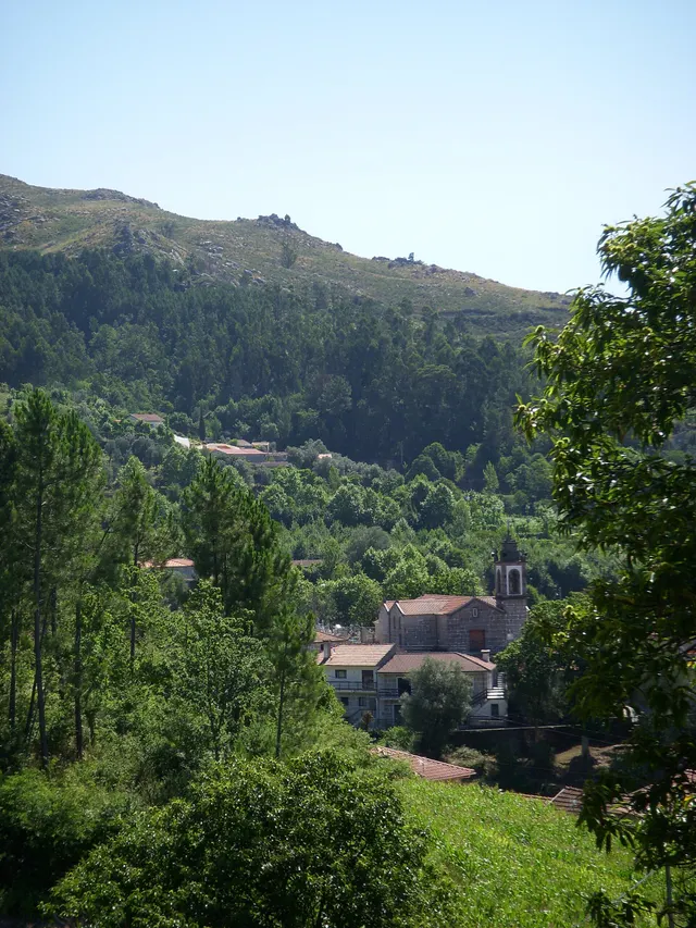
In the lowlands near Tâmega, the Archaeological Charter describes accumulations of sand and clay linked to some of the vegetation with the greatest agricultural potential. The contrast is clear: on the slopes dominate large granite outcrops; by the river, deposited materials help explain another way of cultivating. The same presentation shows a landscape of heads that descend south, with water lines that seek the Tâmega and its tributaries. It is not a soil map of each field, but a key to read the set.

Words in this story: see explanations →
Source and context

Municipality — Archaeological Charter: Orography and geology

Accessed: . Editorial summary; the date of consultation is not the date of the facts.
Council · environmental relations described in the report of 2025

The river begins before the shore

What happens on the ground can travel with the water.

Includes an activity to try →Explore: Follow water to the surface and underground →
Read here and view sources

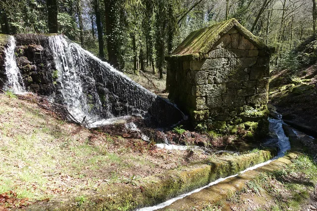
The water flowing to the surface can transport soil and nutrients to the water lines. The municipal environmental report of February 2025 relates this process to erosion and the incorrect use of fertilizers rich in phosphorus and nitrogen. Excessive enrichment in nutrients can favor eutrophication, changing the aquatic environment.

The document also distinguishes groundwater: it states that the excessive use of nitrogen fertilizers can contribute to the accumulation of nitrates and increased salinity; what happens in the field is therefore of interest both to water that we see running and to water that is underground.

They are potential pressures described in an environmental assessment. They do not identify a discharge in a specific field, nor allow assessing a river by appearance. To understand the system, it is worth relating land, surface flow and aquifers, keeping separate general hypotheses and measurements from a location.

Source and context

Municipality — Environmental Report of the PDM review, February 2025, p. 59: land uses and water resources

Accessed: . Editorial summary; the date of consultation is not the date of the facts.
Geographical framework

The Tâmega draws the limit

A river to understand the south of the municipality.

Includes an activity to try →Explore: From limit to landscape →
Read here and view sources

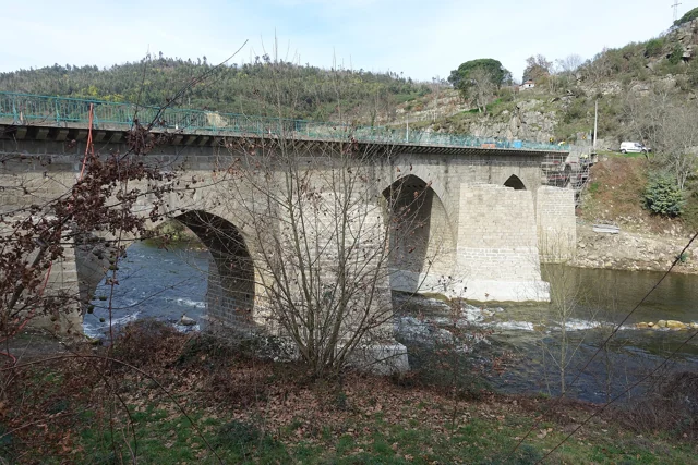
The Tâmega accompanies much of the south and southeast border of Cabeceiras. To the east, the municipal geographical presentation mentions the Bessa River. The water thus helps to situate the territory, along with the mountains of the north and west.

On the south side, the neighboring municipalities are Celorico and Mondim of Basto; this is Ribeira de Pena. These references allow you to start reading the map before going to the bridges, fields and network of tributaries.

To complete this orientation, it looks to the other sides: Montalegre and Boticas to the north, Vieira from the Minho to the northwest and Fafe to the west. Cabreira and Barroso frame the north; the Serra da Lameira, the west. The administrative limit and the water network are two different ways to read the same territory: it now follows the tributaries to see where the water continues.

Source and context

Municipality — geographical framework

Accessed: . Editorial summary; the date of consultation is not the date of the facts.
Municipal hydrographic network

The water from here also reaches the Douro

The rivers are part of a larger network.

Includes an activity to try →Explore: The way from the water to the Douro →
Read here and view sources

Gold, Beça and the Cavez stream enter the right bank of the Tâmega, which is affluent of the Douro. The municipal environmental report allows to follow this link between rivers: a map of Cabeceiras continues far beyond the municipality limits.

A watershed includes the territory that leads water through streams and rivers to a common exit to the sea. It is not only the blue trace of a map. APA also distinguishes the sub-basin, whose flow converges to a point of a watercourse, for example a confluence.

In the scheme of this reading, the names show links between watercourses; they do not draw the boundaries of the respective basins. To perceive the river, it is necessary to include the land that makes it reach water. It is this link that allows to pass from the history of the tributaries to soil erosion and to the life of the banks.

Words in this story: see explanations →
Source and context

Municipality — Environmental Report of the PDM review, February 2025, p. 56

Portuguese Environment Agency — water resources and associated concepts

Accessed: . Editorial summary; the date of consultation is not the date of the facts.

Rio Douro · project announced in April 2025

In the wasteland, the forest finds the water lines

A project of Rio Douro helps to read different functions of the same landscape.

Includes an activity to try →Explore: The slope meets the river →
Read here and view sources

In April 2025, Antar announced the start of an intervention agreed with the local wasteland community of Riodouro, in an area of about 500 hectares of Cabreira partially affected by the fires of 2016 and 2024. The plan presented combined forest production, conservation and recovery of about 40 hectares of riverside vegetation. The proposal helps to realize that managing a hillside also involves water spaces. These figures are objectives announced by the promoter, not a confirmation of completed work or results achieved.

The April news places the beginning of the work in February 2025. For the first phase, it announces about 220 hectares of production species and about 80 hectares of diverse leaves and resins. These areas have different purposes; they are not a balance of plantations carried out.

The relief also enters the project: the promoter describes plateaus, steep slopes and great variation of altitude. The reading of the landscape joins, thus, the form of the land, production spaces and sensitive areas next to the water. There is no complete division here of the 500 hectares that allows to draw all the plots.

Source and context

Antar — announcement of the start of the Riodouro project, 04/04/2025; objectives announced by the promoter

Accessed: . Editorial summary; the date of consultation is not the date of the facts.

Saint Nicholas · hydraulic heritage inventoryed in 2008

Peio also made flour

A river connected fields, dams and mills.

Includes an activity to try →
Read here and view sources

The Levada do Casal record records water captured at Peio, near Ponte do Gado, in Gondarem. The inventory describes five mills along the canal. It is a portrait of the hydraulic heritage, not a confirmation of current operation or public access.

The survey of 26 of February 2008 identifies a channel in natural land and two consorts: Casa do Casal and Quinta do Boyinho, this one with less watering time. It also describes the layout near the Levada de Bouças and a landmark in Sendim placed to resolve a divergence of enjoyment. The channel carried water, but its use also depended on agreements between people.

Source and context

Municipality — inventory of taken, L1 and L18 forms (uplifts of 2008)

Accessed: . Editorial summary; the date of consultation is not the date of the facts.

Saint Nicholas · rivers in 1758

Bridges that winter put to the test

The crossing was part of life by the river.

Includes an activity to try →Explore: Cross, sail or water? →
Read here and view sources

The report of St. Nicholas of 1758 describes three wooden bridges. It says that the winter waters sometimes covered the two highest and even carried some bridges. It is an ancient testimony of the relationship between floods and paths; it does not allow assessing the safety of current crossings. The document names Sendim, Cerdeiró and Ponte do Gado: the crossings helped connect the church to the places of the parish.

The description does not only show the strength of the floods. It refers to a course with many falls of water, difficult to cross the ford and, in some sections, even to follow the banks. The bridges responded to this difficulty of the terrain.

Sendim’s was on the way to the church to this place; Cerdeiró’s served the direction of the Breia. The Bridge of the Cattle was lower than the other two and gave a name to the point where the arms coming from Bucos entered. These details connect the network of roads to the water network, without fixing the position of each structure on the modern map.

Getting to know the parish
Source and context

Basto Land Museum — St Nicholas Parish Memories (1758)

Accessed: . Editorial summary; the date of consultation is not the date of the facts.

Rio Douro · water uses in 1758

In summer, the water took other paths

The levadas linked the flow of rivers to the work of the fields.

Includes an activity to try →Explore: Water connected jobs and places →
Read here and view sources

The memory of 1758 describes the two rivers of Rio Douro running all year round, but arriving at the end of the course with little water in the summer. The vicar linked this decrease to the many levadas that supplied the fields. Dams, waterfalls and mills comprised a landscape of various works.

The crossings also varied: the report mentions wooden bridges between places and the church, as well as stone bridges in Teixeiras and Vilela. The margins were not just production spaces; it was necessary to move from one side to the other. This historical enumeration does not identify surviving structures or current accesses.

The document also explains why boats did not circulate: there were stones, waterfalls and dams, and insufficient flow for navigation. A river could be important for the economy of the parish without being a river transport route.

On the cultivated shores, the report mentions vine oaks; outside the fields, urzeira forests. Thus, the water helped to organize a landscape in which cultivation, vegetation and equipment were found. The answer was signed in 22 May 1758: summer is described as usual behavior, not as a measurement carried out this summer.

Words in this story: see explanations →Getting to know the parish
Source and context

Municipality of Cabeceiras de Basto — Parish memories of 1758: Rio Douro

Municipality — Parish Memoirs of Rio Douro, António Carneiro da Costa, 22/05/1758

Accessed: . Editorial summary; the date of consultation is not the date of the facts.

Saint Nicholas · testimony of 1758

The water watered and made oil

A river, different jobs.

Read here and view sources

In 1758, the parish priest of São Nicolau described taken to the fields and water to move an oil mill in Quinta da Taipa. One of the levadas served Gondarem, Fragua, Penedo and Lamelas. The report helps to imagine the link between river, irrigation and production. It distinguishes three continuous levadas: one for the places referred to and two for the farms of Bouças and Taipa. It also mentions mills fed by dams.

The description also includes a smaller water course, the west, originating in the fountains of the hills of Lapela and Celeiró. In this river, the rector mentions mills and a levada that served the fields of the Casal. He recalls two other destined to Quinta da Taipa, one of which was ruined. The water use network had therefore structures in use and others that no longer worked as before.

This detail helps to read the hydraulic heritage as continuous work: the existence of a canal in an old account does not guarantee its use in another time. The source also distinguishes collective uses from places and taken from farms, allowing to compare different relationships between water, fields and owners.

Getting to know the parish
Source and context

Basto Land Museum — St Nicholas Parish Memories (1758)

Accessed: . Editorial summary; the date of consultation is not the date of the facts.

Abadim · intervention in Peio in 2017

Wood, stone and coconut on the shores of Peio

In Ranha, recovering the river also went by choosing the materials.

Includes an activity to try →Explore: Taking care of the margins in many ways →
Read here and view sources

In Ranha, the margin also tells a history of construction. The intervention inaugurated in 17 June 2017 combined stone, wood, coconut fiber and autochthonous plants. According to the municipal news, sought to stabilize the banks of Peio, recover the riverside vegetation and ecologically rehabilitate the leisure area in Abadim.

The work extended to the support spaces: parking, building and sanitary facilities, bridge and support wall of the road. The intervention in the river was part of a set that articulated the landscape and public use of the place.

The Municipality has framed the project in the compensation and minimization measures associated with the dam of Davões, with financial support from Iberdrola. This link helps to understand the context of the work, in addition to the visible materials. The news documents 2017; it does not prove the current operation of the equipment or the quality of the water for bathing. Consult the practical information in the form of Ranha.

See Fact sheet: Zona de Banhos da Ranha
Source and context

Municipality — inauguration of the renaturalization of Peio margins, news of 20/06/2017

Accessed: . Editorial summary; the date of consultation is not the date of the facts.

Saint Nicholas · environmental history of 1758

The fish that entered the memory

An ancient document also speaks of life in rivers.

Includes an activity to try →Explore: Three Ways to Know a River →
Read here and view sources

The memory of São Nicolau enumerates trouts, bogas and escalos in the main river in little quantity. In the lower course, mentions small trouts. They are names used in the document of 1758, no scientific identifications or confirmation of the current populations.

Domingos Camel de Sousa distinguishes watercourses before talking about fish. The main received two arms coming from Bucos near Ponte do Gado; the smallest was born in fountains of the hills of Lapela and Celeiró and followed to Painzela. This location gives context to the names of the fauna. The memory also comments on the taste of fish, revealing a look connected to food, and not the method of a biological survey.

Source and context

Basto Land Museum — St Nicholas Parish Memories, 22 May 1758

Accessed: . Editorial summary; the date of consultation is not the date of the facts.

Landscape · Rio Douro

Moscoso look at the valley

mountains houses, a stream and a name that stays in your ear.

Includes an activity to try →
Read here and view sources

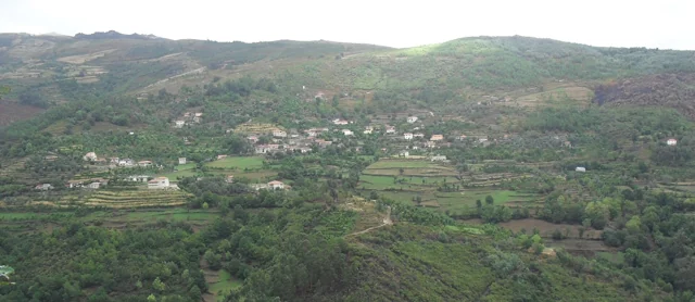
Moscoso, in the parish of Rio Douro, is presented by Visit Cabeceiras as a preserved nucleus of rustic houses of Serra da Cabreira. The village turns to the valley of the river of Cavez, where the description is located the Nariz do Mundo. In the vicinity, it also mentions the waterfall of the Poço das Relvas.

To read this landscape, try to separate three elements: the houses, the valley and the relief in the background. Then put them back together: the village gains context when it is no longer just a set of buildings. The places chips help to continue the discovery; this description does not define a path between them.

See Fact sheet: Moscoso See Fact sheet: Nariz do Mundo
Source and context

Visit Cabeceiras — village Moscoso

Accessed: . Editorial summary; the date of consultation is not the date of the facts.

Water memory · lifting of 2008

The water had its turn

Sundown to sunset, community rule.

Includes an activity to try →
Read here and view sources

The survey of 4 March 2008 describes the water of Levada de Víbora divided into eleven shifts of 24 hours, called couples. Each shift began at sunset and ended at sunset. The initial order changed from year to year.

The names came from houses of Abadim: six couples were associated with the Village of the Tower and five to Santo António. The granite gutter led water from the stream of Busteliberne for irrigation and grinding. Thus, the levada had a visible construction and an equally important time organization. These data belong to the inventory of 2008, not to a current watering scale.

Source and context

Municipality — inventory of taken, L1 and L18 forms (uplifts of 2008)

Accessed: . Editorial summary; the date of consultation is not the date of the facts.

Geographical framework

Cabreira, Barroso and Lameira

Three names to guide the look.

Includes an activity to try →Explore: From the mountain to the river, choose the path →
Read here and view sources

The municipal description uses three mountains to frame Cabeceiras: Cabreira and Barroso to the north, Lameira to the west. They are orientation references, not mountains entirely contained in the municipality.

Neighbors help complete the design: Montalegre and Boticas to the north, Vieira from Minho to the northwest and Fafe to the west. Reading the landscape is also to perceive continuities beyond the administrative line. Start with the names and directions; then approach the look of villages and differences of altitude.

Source and context

Municipality — geographical framework

Accessed: . Editorial summary; the date of consultation is not the date of the facts.

Landscape and agriculture

Peio, gold and stream Cavez

Water also organizes the work of the fields.

Read here and view sources

The agricultural landscape is not only explained by the presence of water. The municipal tourist presentation describes two ways of adapting the land: terraces on the slopes and use of small alluvials associated with Tâmega and courses such as Peio, Gold and the brook of Cavez.

On the slopes, the fields accompany constructed steps; next to the rivers, deposit land is used. They are different ways of working the relief. Reading invites to compare the shape of the fields and their relationship with water, without assigning to all the land the same origin or cultivation.

Words in this story: see explanations →
Source and context

Municipality — landscape and vegetation

Accessed: . Editorial summary; the date of consultation is not the date of the facts.

Landscape · Abadim

Follow the path of the water

Granite mill served by Levada de Víbora, in all Moinhos de Rei, with waterfall and canal in the wooded surroundings. Register 2025.
A mill and the water channel at Moinhos de Rei.© Joseolgonⓘ

The Levada de Víbora approaches nature and human labor.

Includes an activity to try →
Read here and view sources

The Levada de Víbora allows you to relate the water path to the grinding work. The municipal presentation of the PR1 BCC connects the beginning to the Oral Dam, in Abadim, to the Moinhos de Rei, to woods and small watercourses. It also highlights the village and viewpoint of Porto d’Olho and Leisure Park of Víbora. Interest is not only in the destination: the channel helps to understand how the water was conducted and used. To choose the walk, see the track record and compare distance and difficulty; this reading does not replace the current conditions of the route.

Words in this story: see explanations →Compare the walks See Fact sheet: Moinhos de Rei See Fact sheet: Trilho da Levada de Víbora See Fact sheet: Área de Lazer do Oural See Fact sheet: Área de Lazer de Víbora
Source and context

Municipality — Trilho da Levada de Víbora, PR1 BCC

Accessed: . Editorial summary; the date of consultation is not the date of the facts.

Ribeira de Cavez · water and agriculture

From the spring to the fields

A stream helps explain the whole landscape.

Read here and view sources

The brook of Cavez is born on the border of the municipality with Montalegre and ends at Tâmega. Between the mountain and the mouth, the municipal description highlights levadas, mills and irrigation mills: buildings and fields that show different ways to enjoy the water.

On the trail beginning in Vilela, Rio Douro, the narrative goes from the descent to the riverside to the levada and the landscape of the lameiros, then following rural paths and the slope. The return to the village brings another material to the history: the granite masonry of the houses. See the route chart to prepare the walk; this reading explains the landscape, without confirming the conditions of the way on the day of the visit.

Getting to know the parish See Fact sheet: Trilho da Ribeira de Cavez See Fact sheet: Vilela, Rio Douro
Source and context

Municipality — stream of Cavez and agricultural landscape

Accessed: . Editorial summary; the date of consultation is not the date of the facts.

Toasters · Abadim

A village over a thousand meters

In Torrinheiras, the landscape begins at altitude.

Includes an activity to try →
Read here and view sources

Torrinheiras, in Abadim, is presented by the Municipality as the highest settlement in the municipality, about 1020 meters. The track climbs the hill and reaches 1159 meters. They are two distinct altitude references: that of the village and that of a point of the route, not a measure of the accumulated climb of the walk.

The description of the panorama names Gerês, Alvão, Marão and Barroso. Further down, it mentions the brook of Busteliberne, Porto d’Olho and, on the return, mills and grazing of barrosan and maronese cattle. Thus, the mountain tells a story of distances and views, but also of water, villages and work. The visibility and state of the track should be evaluated during the visit.

Getting to know the parish See Fact sheet: Trilho de Torrinheiras
Source and context

Municipality — Trilho de Torrinheiras, altitude, landmarks and landscape

Accessed: . Editorial summary; the date of consultation is not the date of the facts.

Alvite · testimony of 1758

Store water coming from the hill

Small springs helped water the fields.

Includes an activity to try →
Read here and view sources

In the ratio of 1758, the vicar of Alvite described little abundant springs in the Serra da Orada. The residents retained these waters in prey to benefit the fields facing the spring. Saving water was a way to cope with its scarcity.

The same document classified the parish as drought, especially in the summer, and referred to the absence of mills and mills. Two olive oil mills worked with oxen and other animals; to grind cereals, many residents sought neighboring parishes. The portrait links natural resources, techniques and displacements, without allowing to conclude that the same uses or structures continue today.

Getting to know the parish
Source and context

Basto Land Museum — Parish Memories of 1758: Alvite

Accessed: . Editorial summary; the date of consultation is not the date of the facts.

Gondiães e Vilar de Cunhas · memory and landscape

Vilar looks at Beça

Houses, slopes and water make up the landscape of the village.

Includes an activity to try →Explore: From the slope to the paths →
Read here and view sources

The municipal guide of the villages highlights in Vilar the church and the constructions with tops, on a slope facing the landscape of Beça. The description links built heritage, agriculture, livestock and crafts.

Reading this presentation invites to relate scales: the coverage of a house, the whole village and the valley that opens before it. It is a way to know the territory from the documented elements, not the current confirmation of the conservation of each roof or access to the river.

The guide was born from a partnership between Cabeceiras de Basto and Vieira do Minho, within the framework of the Interpretation and Animation Center of Serra da Cabreira. Its presentation seeks to bring the visitor closer to the villages and people. In Vilar, the landscape arises associated with work: fields, animal breeding and handicrafts help to read the place beyond the view over the valley.

Getting to know the parish
Source and context

Municipality — Village Guide of Serra da Cabreira: landscape, work and heritage

Accessed: . Editorial summary; the date of consultation is not the date of the facts.

Landscape and garden · Painzela

The water draws the garden of Piellas

Among the carved bushes, there are other ways to go.

Includes an activity to try →Explore: The garden within the landscape →
Read here and view sources

In Piellas, the water helps to connect garden, forest and fields. The description published by Jardins Magazine places a tank in L next to the wall, close to a passage to the forest of Casa do Boal. Another tank, surrounded by bamboos and buxos, opens for a cultivation field surrounded by forest. The water goes to the stream of Painzela.

The article also describes paths shaded by ramadas and an agricultural courtyard associated with the old production of corn and wine. The farm therefore gathers recreational spaces and work spaces: the garden of carved shrubs is part of a wider landscape.

Try to imagine the fifth in layers: the levels, paths, vegetation and the water system. The description allows to relate these elements, but does not provide a complete map of the hydraulic circuit. Piellas is a private property; the visiting conditions should be consulted on the site's chart.

See Fact sheet: Casa de Pielas, jardins e anexos
Source and context

Jardins Magazine — Gardens of Portugal: Route of the Tâmega, section Casa de Piellas

Accessed: . Editorial summary; the date of consultation is not the date of the facts.

Geology and relief of the municipality

The mountains is also read in stone

Before the roads and houses, there is a landscape of rocks.

Explore: From rock to field, follow the materials →
Read here and view sources

The Municipal Archaeological Charter describes large granite outcrops with erosion marks. The relief descends from the southern periphery of the Cabreira towards the basin of the Tâmega, in a succession of heads. Looking at these forms helps connect the mountain to the valley: the stone is part of the history of the territory, even when it was not worked by anyone.

A rock can change without leaving the place. It is called meteorization to this change: there can be physical fragmentation, chemical transformation of minerals or intervention of living beings. The British Geological Survey gives simple examples: roots that widen cracks, water that freezes and expands in fractures, or rainwater that reacts with minerals. They are general mechanisms; they do not allow to attribute a cause to every block that is in the Cabreira.

When the materials are removed and transported by water, wind or ice, erosion enters the scene. The distinction helps to imagine two steps: the rock changes; part of its materials can then travel. It is not necessary that the two happen at the same rate, nor that a fragment reaches directly into the river.

The reading tour ends in the veigas of the Tâmega, where the municipal source describes deposits of sand and clay. Between the exposed rock and a lowland field there are thus different questions: of what is made the stone, how is changed and where do the transported materials end?

Words in this story: see explanations →
Source and context

Municipality — Archaeological Charter: Orography and geology

British Geological Survey — Weathering: physical, chemical and biological alteration of rocks

Geological Society — Weathering: difference between change and erosion

Accessed: . Editorial summary; the date of consultation is not the date of the facts.

Geology of Vila Nune and Gondiães

Not all the stone is granite

Vila Nune and Gondiães show another part of the geological map.

Explore: The same landscape, different processes →
Read here and view sources

Among the granites, the Archaeological Charter identifies two cores of Paleozoic metasediments. The Vila Nune extends to the northwest, following the alignment of the Peio; the Gondiães flanks the Beça. These are references to understand the diversity of the subsoil, not visiting points or collection sites. The landscape gains another layer when you look at what it is made of.

To understand the name, it is worth separating two stages. Sediments can accumulate, be buried and consolidate into sedimentary rock. If this rock undergoes metamorphism, it undergoes changes caused by conditions such as high temperature and pressure. It is this sedimentary origin followed by transformation that the term metasediment marks.

Metamorphism does not mean melting: USGS explains that the transformation happens without the rock passing the magma. Minerals can reorganize or give way to others. In some rocks, elongated or flattened minerals are oriented and produce a structure in planes, called foliation. Not all metamorphic rocks present it.

They're tools for interpreting the language of the map. They do not allow each stone of Vila Nune or Gondiães to be assigned a mineral, an exact age or a specific process by appearance only. For this, it is necessary to relate the observation with cartography and geological study.

Words in this story: see explanations →
Source and context

Municipality — Archaeological Charter: Orography and geology

British Geological Survey — Rocks and minerals: rock formation, cooling and exposure

U.S. Geological Survey — What are metamorphic rocks?

Accessed: . Editorial summary; the date of consultation is not the date of the facts.

Relief of the municipality

From the mountain to the valley, the map changes height

Look at Cabeceiras north to south.

Includes an activity to try →
Read here and view sources

The environmental report of 2025 places above 800 meters to the north. To the south, near Tâmega, there are land below 200 meters. This contrast helps to read the relief: the landscape opens up from the mountain towards the valley. The Archaeological Charter describes the heads as an amphitheatre facing the south. It also links the narrow strips of the northern parishes with the sharing between mountain and valley: the lived territory does not end at a single altitude.

These values describe sectors of the municipality, not two uniform levels. The report features a smoothing of the relief to the south, towards the Tâmega. In the walk, a village, a slope and the bottom of the valley can help ask questions to the map: where is each place and how does it relate to the water?

A difference in altitude is also not the distance of a walk. Saying that two points are at different heights does not tell how much walking between them, nor does it reveal the slope of all the way. This reading helps to interpret the territory; the conditions of a path require information of its own.

The dominant direction also has exceptions. The Archaeological Charter highlights the waters that descend from the slopes of the Lady of Orada and launch into Peio. Thus, the idea of a landscape facing south does not mean that each stream follows a parallel line to Tâmega. The valleys and tributaries are part of this organization.

Source and context

Municipality — Environmental Report of the PDM review, February 2025, p. 50

Municipal Archaeological Charter — Orography and geology

Accessed: . Editorial summary; the date of consultation is not the date of the facts.

Mineral resources · geological description of the municipality

There's more to the stone than you can see

Volframite and cassitis enter the geological portrait of Cabeceiras.

Read here and view sources

The Municipal Archaeological Charter refers to a geological environment rich in volframite and cassiterite. The two names add a mineral dimension to the landscape of granites and metasediments: they talk about the composition of the subsoil, beyond the form of the hills.

The volframite contains iron, manganese and tungsten. Virtual Microscope, a project with participation from Open University and the Royal Cornwall Museum, explains its importance as tungsten ore. Cassitis is a tin oxide with a formula SnO2, and is an important commercial source of this metal, according to USGS. They're two different minerals, associated with different metals.

A mineral and the metal you can get from it are not the same thing. Volframite is not a piece of metal tungsten, as cassiterite is not ready to use. The interest of these names is precisely in this connection between the matter found in nature and the materials transformed by people.

The municipal description confirms the local geological reference. International sources help explain the minerals, but their examples of exploitation belong to other territories. None of these explanations identify here a visitable mine, an active farm or a collection site.

Words in this story: see explanations →
Source and context

Municipality — Archaeological Charter: Orography and geology

Open University / Royal Cornwall Museum — Virtual Microscope: Wolframite

USGS — Tin Statistics and Information: cassiterite as a tin source

Accessed: . Editorial summary; the date of consultation is not the date of the facts.

Ribeira de Penoutas · reported intervention in August 2026

Clearing a stream is also knowing what stays

In the stream of Penoutas, fetuses are part of history.

Includes an activity to try →Explore: Water goes through different stories →
Read here and view sources

In August, 2026, the Municipality described an intervention that removed residues from the bed and the margins and controlled part of the vegetation. But it also highlighted what was preserved: herbaceous plants belonging to the margins and wetlands, including fetuses. This choice shows how the maintenance of a stream can reconcile the flow of water with the vegetation that accompanies it. It is the municipal report of that action, without identifying species of fetuses or measuring their ecological results.

The news separates tasks that may seem the same in a quick observation: taking out garbage, controlling forests and preserving plants from the margins. It also refers to the objective of improving the use of that space by the population. Cleaning, disposal and vegetation are therefore three aspects present in the report.

The municipal appeal to the correct disposal of waste links maintenance to daily life. Looking at a stream allows asking not only how water runs, but also how people take care of the space around them.

Source and context

Municipality — cleaning action in the Penoutas River, 07/08/2026

Accessed: . Editorial summary; the date of consultation is not the date of the facts.

Refojos · opening in 2013 and urban transformation

A stream in the history of Casa do Tempo

The renovation of the village centre also passed through the water.

Includes an activity to try →Explore: Memory, buildings and water →
Read here and view sources

The Casa do Tempo opened in 2 August 2013 next to the Monastery of Refojos. In the municipal description, the recovery of old housekeeping houses is part of a broader transformation: connecting the Republic Square to the new areas of the village, creating green spaces and treating the banks of the riverside of Penoutas. The interpretive center thus allows to tell two stories together: the memory of Cabeceiras and the change of its urban landscape.

The Municipality describes the acquisition of part of the returned houses and the negotiations that preceded the intervention. Reutilizing the buildings and transforming their surroundings appear as parts of the same project, rather than separate stories.

The multimedia component of the center was presented as a way to know territory, people, nature, uses and customs. Thus, the stream does not appear only as a scenario: it integrates the history of how that village space gained new functions. To plan a visit, the site's file gathers the practical information available.

See Fact sheet: Casa do Tempo
Source and context

Municipality — Casa do Tempo: opening in 2013 and requalification of the surroundings

Accessed: . Editorial summary; the date of consultation is not the date of the facts.

Saint Nicholas and Painzela · testimony of 1758

A bridge for loaded cars

Three springs and a crossing connected two parishes.

Includes an activity to try →Explore: Pass, water and grind →
Read here and view sources

In 1758, the parish priest describes a small river born from three sources in the hills of Lapela and Celeiró. It entered in Painzela by Vilarinho, where a wooden bridge supported loaded cars. The testimony does not identify a visitable crossing today.

The same river also moved mills and provided water to one taken to the fields of Casal. The author recalls two other derivations linked to the Taipa farm, one of them already ruined at the time of the report.

This description combines transport, grinding and watering. A bridge allowed to pass; a levada diverted part of the water to another use. They were not equivalent functions, although they participated in the same work landscape. The reference to a ruined structure also shows that the document records changes and losses, in addition to what was in operation.

Words in this story: see explanations →
Source and context

Basto Land Museum — St Nicholas Parish Memories, 22 May 1758

Accessed: . Editorial summary; the date of consultation is not the date of the facts.

Faia · municipal description of the settlement

A road helps to read the Faia

Not all villages are organized around a single center.

Includes an activity to try →
Read here and view sources

In the south of the municipality, along the limit with Celorico from Basto, the Faia is described by the municipality through the proximity to Arco de Baúlhe and the distribution of the settlement along the EN206. The road helps to understand an occupation that is not limited to a single center.

The presentation brings accessibility, agriculture, viticulture and crafts such as tannaria and manual manufacture of footwear. To discover the parish, it is worth crossing the houses and paths with these working memories. This reading of the municipal source does not replace current cartography or identifies open workshops.

Source and context

Municipality — presentation of Faia: settlement and traditional activities

Accessed: . Editorial summary; the date of consultation is not the date of the facts.

Geological complex of Cabeceiras de Basto · regional study

Granite also changes grain

A stone of uniform appearance can reveal differences when looking closely.

Includes an activity to try →
Read here and view sources

In the study by A. Almeida, the granite complex of Cabeceiras de Basto does not have a single grain size. The classification uses three average intervals: 0,5–1 millimeter for fine grain, 2–4 millimeters for medium and 5–7 millimeters for coarse grain. In the last group, the author also mentions rare larger crystals, with 8–10 millimeters.

This allows distinguishing two observations: the usual size of the grains and the presence of some crystals that stand out. The description does not transform each visible point of a photograph into a measurement. To compare sizes in an image, a scale is required; a magnification on the screen may make small grains look large.

The study refers to three genetically independent series, although they have similar chemical composition ranges. Appearance is an entrance to research, not all explanation of origin. On a wall or a façade, the grains arouse curiosity, but do not prove for themselves where the stone came from.

Words in this story: see explanations →
Source and context

A. Almeida (1998) — Metallurgical specialisation of the peraluminous granites of two micas of the Cabeceiras de Basto complex, IGM 84(1), B-79–B-82; p. 325 of the PDF

Accessed: . Editorial summary; the date of consultation is not the date of the facts.

Geological complex of Cabeceiras de Basto · dating cited in the study

A story with millions of years

The rock age and landscape shape are not the same question.

Explore: Three questions for the same stone →
Read here and view sources

The work of A. Almeida refers to a dating of the complex of Cabeceiras de Basto by the uranium-chumbo method, using the minerals zircon and monazite. The result cited is a minimum age of 311 ± 1 million years. It is a geological reference to the rock formation studied: it does not date the construction of a wall, nor establishes when a hillside has acquired the form that we see today.

The article integrates the minutes of the V National Congress of Geology, published in 1998. Upon reaching the value, Almeida refers to a work of geochronology with other authors, indicated in the bibliography. This chain of references allows us to understand where the number comes from: it is a result of investigation, not an age estimated by the color or size of the grains.

Reading a landscape forces you to separate time scales. One thing is the age attributed to the rocky complex; another, the transformation of relief; another, the moment when a stone was used in a construction. The three stories can cross on the same wall, but need different evidence.

Source and context

A. Almeida (1998) — Metallurgical specialisation of the peraluminous granites of two micas of the Cabeceiras de Basto complex, IGM 84(1), B-79–B-82; p. 325 of the PDF

Accessed: . Editorial summary; the date of consultation is not the date of the facts.

General geology · reading of granite texture

The small grains tell how the rock cooled

Granite holds minerals that can be distinguished by the eye.

Includes an activity to try →
Read here and view sources

The tutor of Adam Mendes, of the Portuguese Association of Professors of Biology and Geology, relates the granular texture of granite to the slow cooling of magma in depth. Among its characteristic minerals are quartz and feldspates; there may also exist mica. This general explanation helps to look at the stone more carefully, but recognizing colors and grains is not enough to identify the origin of a sample.

If granite has formed in depth, how do we see it in an outcrop? The British Geological Survey relates the exposure of these rocks to the survey of land, erosion and change over millions of years. The history of formation and the history of surface exposure are different stages.

It is also convenient to distinguish rock and mineral. In granite, different minerals appear associated in crystals that fit. Recognizing this combination is different from observing a single isolated mineral. The relative sizes of the crystals and their disposition help to describe the texture; an isolated color does not tell the whole story of the rock.

Source and context

Adam Mendes / APPBG — Characterize basalt, gabro, andesite, diorite, riolite and granite; RTP Teach, 2020

British Geological Survey — Rocks and minerals: rock formation, cooling and exposure

Accessed: . Editorial summary; the date of consultation is not the date of the facts.

Council · Water resources in the 2025 report

Under the ground there's also water

The water map doesn't end up on the surface.

Includes an activity to try →Explore: Look at the water in different ways →
Read here and view sources

The municipal environmental report of February 2025 identifies, in the groundwater, units of the Old Indifferentiated Maciço of the Douro, Ave and Cávado basins. In the same document, the surface water masses of the municipality belong to the Douro Hydrographic Region. They are two distinct readings of the territory: the network of rivers to the surface and the water underground. The reference does not indicate visitable wells nor allows to evaluate the water of a spring.

How does water fit in the rock? The USGS explanation points to pores and fractures: spaces between particles and cracks that may be filled with water. Porosity describes the available spaces; permeability, the ease with which water circulates through the material. Having spaces is not enough: the connection between them also matters. It's a general explanation, not a measurement of the rocks of Cabeceiras.

Source and context

Municipality — Environmental Report of the PDM review, February 2025, pp. 56–58: water network and resources

USGS — Water Science School: groundwater, porosity and permeability

Accessed: . Editorial summary; the date of consultation is not the date of the facts.

Refojos and São Nicolau · uses described in 2025

Water also reaches the light and fields

The same landscape brings together different uses.

Explore: From moving water to electricity →
Read here and view sources

The environmental report of 2025 relates water resources to electricity production and irrigation. It identifies the Cefra Hydropower Plant in Refojos, and the São Nicolau mini-hydric. They are documentary references to water use, without confirmation of public access or current operation. Add to them the stories of mills and levadas: the relationship between water and work goes through different times.

How does it go from current to electricity? Water runs a turbine connected to a generator. Flow and downgrade influence the available energy, explains the Department of Energy. It is the general principle that the scheme allows you to explore; it does not describe the specific equipment of the two local facilities. Thus, watering fields, grinding cereal and producing electricity are different uses of a resource connected to the landscape.

Words in this story: see explanations →
Source and context

Municipality — Environmental Report of the PDM review, February 2025, pp. 56–58: water network and resources

U.S. Department of Energy — How Hydropower Works: turbine, generator, flow and downgrade

Accessed: . Editorial summary; the date of consultation is not the date of the facts.

Climate of the municipality · characterization in the report of 2025

The landscape has a rhythm of rain and heat

The same place tells different stories throughout the year.

Includes an activity to try →Explore: The same landscape, different questions →
Read here and view sources

The environmental report of 2025 describes colder and rainy winters, with higher rainfall in December and January, and warmer and drier summers. July and August stand out by the heat. It is a characterization of the weather, not a forecast for the next visit. To know a place, compare it in different months: water, leaves and flowers can offer new clues.

The IPMA explains that climate normals use periods of 30 years. They gather monthly and annual values of elements such as temperature and precipitation. An isolated month and a series of decades therefore answer different questions.

When comparing graphs, look for the location and the reference period: averages calculated for different intervals do not have to match. The long series allow you to study variations and trends. The observations you make on a tour help you get to know that day and that place; they do not replace a climate series and alone describe all the altitudes of the municipality.

Words in this story: see explanations →
Source and context

Municipality — Environmental Report, February 2025, pp. 50, 55 and 139

IPMA — Climate normals: periods and reference values

Accessed: . Editorial summary; the date of consultation is not the date of the facts.

Abadim · water and grinding in memory 1758

Two streams worked six mills

Few water could also keep a landscape moving.

Includes an activity to try →Explore: From water to food →
Read here and view sources

In 1758, the abbot of Abadim described two streams that went down south, were near Ponte de Pé and went to Tâmega. The water was small, but ran all year round. The report mentions trouts and bogs, without identifying species with scientific names.

In the regato a poente, marks the bridge of cantaria da Ranha. Of the several mills existing on the two water lines, six belonged to the parish. This count does not identify the current buildings nor allows to conclude that they were the same as the assembly today called Moinhos de Rei.

The Abbot describes rapid currents and free use of the waters by neighboring peoples. Thus, little water and movement were not incompatible ideas in his portrait. Reading gains another dimension when approaching the fields: the same document distinguishes the cereals produced in the various places. The regattos belonged to a landscape of cultivation and transformation, although memory does not tell which mill received the cereal from each village.

Words in this story: see explanations →
Source and context

Municipality — Parish memories of Abadim, José Antunes, 22/05/1758

Accessed: . Editorial summary; the date of consultation is not the date of the facts.

Gondiães · 2008 municipal inventory

♪ Four puddles, a neighborhood runaway ♪

In Gondiães, water storage and driving was part of the collective work.

Includes an activity to try →Explore: Store, drive and distribute →
Read here and view sources

Four puddles fed a common infrastructure. The March 20 record of 2008 describes the Rego das Poças, also called Levada da Neighbourhood, in Gondiães: about two kilometres of canal for irrigation and milling, serving the mill of the Tarroeiro.

The Puddles of the Place were located in the Scouts. Three were close to each other; the fourth, farther away. Up to the entrance of the village, the canal followed on natural ground; inside the place passed the stone strut. Store and conduct the water required, therefore, different elements and materials.

The inventory identifies collective ownership and exploitation by the levada consorts. It records seasonal shifts of water, but leaves the time of undetermined construction. The date of the survey is not the age of the work. The indication of use and the state of conservation belong to the portrait of 2008, without confirming the current situation or access.

Words in this story: see explanations →
Source and context

Municipality — inventory of levadas, fiche L29: Rego das Poças, withdrawal of 20/03/2008

Accessed: . Editorial summary; the date of consultation is not the date of the facts.

Saint Nicholas · hydraulic heritage inventoryed in 2008

A log led the force of the water

In Quinta de Covas, the history of olive oil intersects with that of energy.

Explore: Water changes work →
Read here and view sources

The inventory of 27 of February 2008 located the mill of Quinta de Covas in Parada, in the parish of Cabeceiras de Basto. The water came from a levada with a weir in Peio. Before arriving to the castor, it passed through a gutter excavated in a trunk: wood was also part of this hydraulic construction.

The building brought together an olive oil mill, a mill and a wine mill. The form associates the decommissioning of the mill and the mill in 1994 to the entry into operation of a hydroelectric power station, which conditioned the available motor force. It is the explanation recorded in that survey, not an independent evaluation of the operation of the plant.

The document describes private heritage and equipment already without the necessary elements for grinding. This story does not indicate public access or current conditions of conservation.

Source and context

Municipality — inventory of olive oil mills, record L.A.5, withdrawal of 27/02/2008

Accessed: . Editorial summary; the date of consultation is not the date of the facts.

Cabeceiras de Basto · windmill architecture studied in 2011

Above, the grinding; below, the movement

A mill is also organized vertically.

Includes an activity to try →Explore: From the water to the building →
Read here and view sources

The study published by the Museum in 2011 describes two levels in the mills of Cabeceiras: above is the mill; below, in the cabouco, the motor mechanism. The form of the building accompanies the operation of the mill. The survey records rectangular plants of varied dimensions, with the exception of a circular plant sour.

The granite dominates the walls, but not all the stone receives the same treatment. The study highlights the points subject to constructive requirements: corners, doors, windows and elements through which the water passes. In the wedges, the stones help to lock the construction; pads and shoulder pads frame the spans. An irregular wall can thus coexist with carefully chosen pieces.

This description belongs to the historical study, not to an inspection of the current buildings. To read the landscape, start with the route of the water and then ask where were the motor force and the work of grinding.

Words in this story: see explanations →
Source and context

Basto Land Museum — Mills Cabeceiras de Basto: construction form, 04/05/2011

Accessed: . Editorial summary; the date of consultation is not the date of the facts.

Time travel

Documents, details and traditions: there is more to discover than a date on a stone.

Choose a story · 17
Cabeceiras de Basto · reading of the Parish Memories

Three questions to the past: land, mountains and river

The Parish Memories were born from an inquiry.

Includes an activity to try →
Read here and view sources

In 1758, an inquiry to the parish priests sought to gather information about the Portuguese parishes. According to the presentation of the Museum of Lands of Basto, it was organized in three major themes: land, mountains and river. By disseminating the texts in 2011, the Museum explained that it had updated the language to make them more accessible to students. Reading a transcript is therefore also to know the work of who made the document readable to other readers.

Source and context

Basto Land Museum — Presentation of Parish Memories, 08/02/2011

Accessed: . Editorial summary; the date of consultation is not the date of the facts.

Arco de Baúlhe e Vila Nune · municipal heritage description

The Triangle Facing Water

A detail of the Old Bridge helps to find out which side the river comes from.

Read here and view sources

At Ponte Velha de Arco de Baúlhe, a semicircular arch holds the board over the Gold River. The municipal description attributes the construction to the 18th century.

The triangular seak is upstream from where the water comes from. This detail allows you to read the bridge beyond its silhouette. The shape of the arch itself does not prove a Roman origin.

Words in this story: see explanations →See Fact sheet: Ponte Velha de Arco de Baúlhe
Source and context

Municipality — Cultural heritage, bridges of Arco de Baúlhe and Moimenta

Accessed: . Editorial summary; the date of consultation is not the date of the facts.

Rio Douro · medieval archaeology

Two graves, one direction

In Rio Douro, guidance helps to interpret the past.

Read here and view sources

In the Moira Camps, the Municipality describes two oriented graves from east to west. It includes them in the Christian funeral practices of the Northwest and presents a broad chronology between the 9th and 13th centuries. The name of the place and the interpretation of traces are different clues, which should be read together.

The record uses the term inhumation: it is about burying the body. The east–west direction and general configuration are elements of the interpretation presented, while the 9th to 13th centuries delimit an interval of several centuries, not an exact date.

Compare these graves with Asnela's mammoths helps to avoid a unique reading of all that is ancient. Both are funeral testimonies, but the inventory proposes periods and types of different structures. The name of a site does not replace the analysis of its traces.

Words in this story: see explanations →Getting to know the parish
Source and context

Municipality — archaeological inventory, interpretations and chronologies

Accessed: . Editorial summary; the date of consultation is not the date of the facts.

Bucos · transport in 1758

A small bridge, a long way

Married was in the way of a lot of people.

Includes an activity to try →Explore: Paths that served the life of the village →
Read here and view sources

In Casares, a wooden bridge integrated the real road to Braga and communications with Trás-os-Montes, according to the memory of 1758. Before the movement, the vicar defended building it in stone. It was a request, not the confirmation of a work.

The source distinguishes this passage from small walkways made with a wooden beam, for pedestrians. Different paths responded to different uses.

The passage not only served the village. The vicar describes a public road and very frequented, linking Braga to the term of Basto and Trás-os-Montes. The bridge emerges, as a local point of a larger network. The recommendation to replace it by chanting shows the author to assess a need, besides inventing what existed.

In the same rivers, the water moved mills and was used by farmers in the fields. The crossing, grinding and watering appear in the same portrait of the territory. A bridge can be read by what it allows to do: reach another place, maintain a communication or approximate works separated by water.

Words in this story: see explanations →Getting to know the parish
Source and context

Municipality — Parish memories of Bucos (1758)

Accessed: . Editorial summary; the date of consultation is not the date of the facts.

Rio Douro · archaeological interpretation

A castle you read on the ground

In Eiró, the circular shape and moat tell a story.

Includes an activity to try →Explore: The land and documents →
Read here and view sources

The municipal inventory interprets the vestiges as a fortified motorcycle-type residence from the middle of the 13th century. It relates it to the castle referred to in the 1258 Inquisitions. The circular shape rests on a stone and gravel landfill, surrounded by a moat. The municipality highlights the position over the valley of Rio Douro, link between Refojos and the plateau Barrosão. The reading combines ground and document, without reconstructing the missing building for sure.

The document of 1258 adds a social dimension to the form of the land: according to the municipal interpretation, almost all residents of Santo André of Rio Douro had an annual obligation to move to the castle. The reference links fortification to the community organization, although it does not clarify here all the associated tasks.

The inventory compares construction with examples from Brittany. It is a comparison of forms and techniques, not a proof of the origin of its builders. The location in the middle of the hillside helps to understand the relationship between defense and passage through the valley.

Getting to know the parish
Source and context

Municipality — archaeological inventory, interpretations and chronologies

Accessed: . Editorial summary; the date of consultation is not the date of the facts.

Rio Douro · archeology and oral tradition

The village that stayed in memory

The traces of the Old Village of Toninha count for another time.

Includes an activity to try →Explore: Other clues in the territory →
Read here and view sources

In the Old Village of Toninha, the municipal inventory proposes occupation between the 13th and 16th centuries. It compares the constructive remains with other serran settlements, including examples in Lindoso and the abandoned village of Juriz in Montalegre. Already the plague that would have caused the people to leave belongs to the popular tradition. They are different paths to know the place: comparing buildings and collecting memories.

There is a third clue: the Investigations of 1258. The inventory proposes that the village may correspond to one of the ten couples then assigned to Juguelhe. It is a probable identification presented by the author, not an equivalence demonstrated. Comparisons with other places help to formulate this interpretation.

Imagine three cards on the table: the buildings, the document of 1258 and the narrative of the plague. Each opens a different question. What forms are repeated in other villages? What places appear in the document? What explanation conveyed the tradition? The discovery begins by crossing these clues without confusing them.

Getting to know the parish
Source and context

Municipality — Old village of Toninha: proposed chronology, parallels and inquiries of 1258

Accessed: . Editorial summary; the date of consultation is not the date of the facts.

Rio Douro · archaeological interpretation

A village drawn on the hillside

In Monte do Castelo, relief is part of history.

Read here and view sources

The municipal inventory proposes the existence of a small fortified village of the first millennium before Christ. The interpretation is based on the platforms of the land and on the position over an irrigated area. It is not necessary to imagine a medieval castle: here, the word of the toponym accompanies traces of another era.

The small elevation and regular platforms are two clues used in the interpretation. The position allows mastering an irrigated floor extending north. The argument thus combines the form of the land with the relationship between the village and the surrounding area; the toponym alone does not solve dating.

Getting to know the parish
Source and context

Municipality — archaeological inventory, interpretations and chronologies

Accessed: . Editorial summary; the date of consultation is not the date of the facts.

Cavez · Parish memories of 1758

A bridge that deserved praise

Ponte de Cavez on the river Tâmega, with stone arches, board and wooded banks.
Ponte de Cavez · crossing Tâmega© Joseolgonⓘ

In 1758, the Cavez Grand Bridge impressed the parish priest.

Explore: Two shores, several stories →
Read here and view sources

In the parochial memory, the crossing of the Tâmega appears described as a great stone bridge, well worked. The author even considers it the best of that river. The praise belongs to the look of those who wrote: it reveals the importance it attributed to the construction, without functioning as a technical comparison between bridges.

In the same memory, the Tâmega appears as a strong current, especially in winter. The document distinguishes the crossing from the use of water: it describes mills and explains that the river was too deep to water the fields in that stretch. The bridge can be read in this set of relations between margins, displacements and work.

Notice the difference between observing a construction and evaluating it. The existence of the bridge is information; considering it the best is an appreciation. The two say something about the past, but answer different questions.

Getting to know the parish See Fact sheet: Ponte de Cavez
Source and context

Municipality of Cabeceiras de Basto — Parish memories of 1758: Cavez

Accessed: . Editorial summary; the date of consultation is not the date of the facts.

Outeiro · landscape and historical interpretation

The relief gives a clue to the name

A gently wavy landscape on the western shore of the municipality.

Includes an activity to try →Explore: Read Outeiro by three paths →
Read here and view sources

On the western bank of the municipality, next to Fafe, Outeiro is described by the Municipality as a softly wavy relief plateau. The presentation relates the name to this landscape and points to the proximity of the headquarters and the fixing of houses along the road.

The municipal page proposes a medieval interpretation of the names of the places and refers to the scarcity of archaeological data. This formulation needs to be dealt with with the inventory of the PDM published in 2026, which identifies three archaeological sites in Outeiro. The name of the parish still does not itself provide a date of foundation.

Words in this story: see explanations →Getting to know the parish
Source and context

Municipality — Outeiro, relief and hydrographic network

Diary of the Republic — Notice No 16185/2026/2, PDM Cabeceiras de Basto, archaeological inventory AQL34–AQL36, p. 92 (29/06/2026)

Accessed: . Editorial summary; the date of consultation is not the date of the facts.

Local legend · Ponte de Cavez

The voice that had built above

Ponte de Cavez on the river Tâmega, with stone arches, board and wooded banks.
Ponte de Cavez on the Tâmega · the monument to which legend refers.© Joseolgonⓘ

Around the bridge, memory also invented paths.

Includes an activity to try →
Read here and view sources

The legend published by the Museum makes the masons try to build the bridge in Vila Franca and then by the Poço das Laranjeiras. In both places, a supernatural voice sent up the river. Tradition attributed it to Saint Bartholomew.

On the third attempt, the narrative places the work next to the chapel. It is a story about the memory of the place, not documentary proof of the choice of the site or an itinerary to look for the episodes.

In another passage of the tradition collected by the Museum, the food of the builders gains a miraculous explanation: there are sources of water, wine and olive oil and fish appear in the river. The narrative associates the effort of construction to religious protection. Reading it alongside the history of the works allows to know two different ways of telling the same place.

See Fact sheet: Ponte de Cavez See Fact sheet: Capela de São Bartolomeu de Cavez
Source and context

Land Museum of Basto — Ponte de Cavez, 27/02/2022

Accessed: . Editorial summary; the date of consultation is not the date of the facts.

Holy Lady · memory of 1758

Not all bridges were stone

The wood also united the banks.

Read here and view sources

The memory of 1758 lists three wooden bridges in the parish: Vagalhafos, in Quinta de Vila de Lobos; Santa Senhorinha, near the church; and Olela. Names approach the crossings of the farms, the place of worship and the inhabited places.

The same report mentions singing bridges in São Clemente and São Martinho do Arco de Baúlhe. Wood and stone appear, thus, in a single description of the river. The enumeration does not provide construction dates nor proves the survival of structures.

Words in this story: see explanations →
Source and context

Municipality — Memória de Santa Senhorinha, 23/05/1758; transcript of José Viriato Chapel (2003)

Accessed: . Editorial summary; the date of consultation is not the date of the facts.

Regional rail link · Celorico bridge Basto

To get to the Arc, the line needed to cross another valley

The history of the Cabeceiras train also passes through the neighboring municipality.

Includes an activity to try →Explore: A bridge ready, an uncompleted connection →
Read here and view sources

Before reaching Cabeceiras, the line had to cross the valley of the river of Veade. The bridge of Matamá is in the Union of the Freguesies of Veade, Gagos and Molares, in Celorico of Basto. According to the Museum, its six granite arches form a structure about 190 meters long and 52 meters high.

The report distinguishes two moments: the opening of the bridge in 5 June 1936, and the entry into railway use in 15 January 1949, with the opening of the Celorico section of Basto–Arco de Baúlhe. Having the bridge built did not immediately mean having trains arriving at the Arc. This regional history helps to realize the time needed to complete the connection.

The report of the Museum attributes the responsibility of the work to engineers Jorge Vieira Bastian and Manuel Gonçalves Costa. The dimension of the structure helps to realize the challenge of taking the railway through the valley; the chronology allows to separate this work from the entry into service of the complete connection.

Source and context

Basto Land Museum / Pedro T. Gonçalves — Matamá Railway Bridge, 28/07/2026

Municipality — Land Museum of Basto: a journey through the history of the region, pp. 28–29

Accessed: . Editorial summary; the date of consultation is not the date of the facts.

Refojos de Basto · photography and biography

From Cancela to portraits of Brazil

A photographer from Refojos left a mark across the Atlantic.

Includes an activity to try →
Read here and view sources

Joaquim Insley Pacheco was born in the place of Cancela, in Refojos de Basto, according to the Museum of Lands of Basto. Photographer and painter, became one of Brazil's outstanding portraitists. The Brazilian National Library documents his appointment as Photographer of the Imperial House in 1855. History thus links a place of the municipality to the early days of photography in Brazil.

The exhibition of the National Library adds a learning link: Pacheco was a student of Frederick Walter, who arrived in Fortaleza in 1847 with daguerreotype equipment and also acted as a magician. Photography, teaching and show intersect in this story of the first professionals.

The recognition of 1855 places Pacheco in Rio de Janeiro and in the court of D. Pedro II. It is three points to follow the biography: the place of origin, learning and professional recognition. The relationship between them helps to discover how a history of Refojos participates in a broader history of the image.

Do you want to move from biography to image? The presentation of 2016 on the official blog of the National Library shows a portrait of D. Pedro II, dated 1883 and attributed to Pacheco, from the collection of the institution. The legend allows to connect an author name, a person portrayed, a date and a collection. It is a concrete example to observe at the source and compare with the photographer's history.

Source and context

Basto Land Museum — Joaquim Insley Pacheco, 27/03/2026

National Library of Brazil Foundation — a photographer, an editor and a zoologist

National Library Foundation — presentation by Joaquim Insley Pacheco and portrait by Pedro II (14/10/2016)

Accessed: . Editorial summary; the date of consultation is not the date of the facts.

Rio Douro · hypothesis of relationship between archaeological sites

Tombs and village: an uninvestigated connection

At Portela de Asnela, the landscape leaves a question.

Explore: Compare traces, distinguish hypotheses →
Read here and view sources

The municipal inventory describes mamoas in Portela de Asnela, in Rio Douro, and proposes a relationship with the village of Castelo, in Formigueiro, about a kilometer north. Proximity supports a hypothesis; it does not in itself prove that the two sets were used by the same community.

The fiche identifies structures of the anther and cyst type within the funerary assembly. It proposes a dating in the second or first millennium before Christ, supported by ceramic materials and in comparison with similar sets of the Northwest mountains.

There are therefore two distinct questions: when will these monuments have been built and what connection could they have had with the nearby village? A proposal for chronology does not automatically solve the second. The inventory presents this connection as a hypothesis, preserving space for future research.

Words in this story: see explanations →
Source and context

Municipality — archaeological inventory, interpretations and chronologies

Accessed: . Editorial summary; the date of consultation is not the date of the facts.

Rio Douro · places and hermits described in 1758

Fifteen places, a network of chapels

The distance from the church also shaped the lives of the villages.

Includes an activity to try →
Read here and view sources

In the memory of Rio Douro of 1758, the vicar lists fifteen places and places the church outside the village. He also refers to fifteen hermits, explaining their relationship with religious assistance to people living far from the home.

St. Stephen stayed outside Eiró; other invocations accompanied names of villages, such as Santa Ana in Toninha, São Gonçalo in Vilela and São Frutuoso in Leiradas. The document also distinguishes religious responsibilities from Refojos, private and residents. It is a historical network of places, devotions and care, without confirming the conservation or current access to each building.

Source and context

Municipality — Parish Memoirs of Rio Douro, António Carneiro da Costa, 22/05/1758

Accessed: . Editorial summary; the date of consultation is not the date of the facts.

Cavez · settlement and devotion in 1758

Eight places and six chapels

In Cavez, an ancient list draws relations between villages, residents and monasteries.

Includes an activity to try →
Read here and view sources

In 25 of May 1758, the vicar Manuel Pacheco da Cunha numbered eight places: Cavez, Vila Franca, Ponte, Arosa, Rabiçais, Moimenta, Revorça and Parada. He located the church in the middle of the parish and described six chapels. Names help to recognize a hammock; they are not a current list of administrative places.

São Gregório, in Vila Franca, São Mamede, in Arosa, and Santa Maria Magdalena, in Moimenta, were attributed to the abbot of Pombeiro, with its maintenance linked to the Benedictine congregation of Tibães. São Bartolomeu, on the Bridge, had as patron João Correia, of Guimarães. In São Caetano, in Raviceis at the passage of the chapels, and Santa Luzia, in Revorça, the charge was for the residents. The transcription itself uses the variants Rabiçais and Raviceais.

The report also describes five altars in the matrix and a brotherhood of the Souls. The parish appears as a space of worship and collective organization, with distinct responsibilities. The pilgrimage of São Bartolomeu is mentioned for 23 and 24 of August; they are dates of historical testimony, without functioning as current agenda.

The parish links went beyond the chapels. The vicar wrote that Cavez did not have their own mail and resorted to Raposeira, which was located to a league. He also indicated the absence of fair in the parish. They are clues to think where news arrived and where services were concentrated at that time; they do not describe the current offer nor allow automatically to convert the league into a road distance.

Getting to know the parish See Fact sheet: Capela de São Bartolomeu de Cavez See Fact sheet: Igreja de São João de Cavez e cruzeiro
Source and context

Municipality of Cabeceiras de Basto — Parish memories of 1758: Cavez

Accessed: . Editorial summary; the date of consultation is not the date of the facts.

Vila Nune · historical look to the margin of Atei

The work was on the other side

A memory of Vila Nune also looks at Atei.

Includes an activity to try →
Read here and view sources

In describing the Tâmega in 1758, the vicar refers mills that worked in the summer, in front of the parish, in the limits of São Pedro de Atei. He also recalls traces of attempts to build levadas and dams in the neighborhoods.

The reference shows how the report crosses the river. The mentioned mills are on the bank of Atei: this reading does not transform them into patrimony located in Cabeceiras or confirms traces visitable today.

Source and context

Municipality — Parish Memoirs of Vila Nune, 23/05/1758

Accessed: . Editorial summary; the date of consultation is not the date of the facts.

Read the landscape through the plants

Trees, forests, vineyards and fields reveal different ways of occupying the territory.

Choose a story · 7
General botany · alder

Seeds that travel by water

Alder has a close relationship with rivers.

Explore: The tree, the river and the craft →
Read here and view sources

In the University of Évora profile published under the name Alnus glutinosa, alder seeds have air-containing tissues that aid dispersal by water. The tree tolerates long periods with submerged roots. Woods dominated by alder are known in Portuguese as amiais.

Its connection with water thus extends from growing along banks to the journey of its seeds. There is also a naming change to understand: Flora-On uses Alnus lusitanica for native Portuguese alders, citing a 2017 study. Here each name remains linked to its source; the story does not identify a particular tree in the municipality.

The profile published as Alnus glutinosa describes a deciduous tree, which loses foliage for part of the year. The leaves are alternate with doubly toothed edges; the bark, smooth when young, becomes darker and cracked. These features concern different plant parts and different stages of its life.

That source gives December to February as the flowering period. Male flowers appear in elongated groups called catkins, while female groups have a different shape. Winter can therefore reveal details hidden on a visit when the crown is full of leaves. This calendar belongs to the consulted description and may vary with local conditions; it does not announce flowering for a particular tree in Cabeceiras.

Words in this story: see explanations →
Source and context

University of Évora — Alnus glutinous, breeding and habitat

Portuguese Society of Botany — Flora-On, Alnus: ecology, symbiosis and taxonomic note

Accessed: . Editorial summary; the date of consultation is not the date of the facts.

Agricultural landscape

Olive trees, cork oaks and vines

From the hillsides to cultivated river plains.

Includes an activity to try →
Read here and view sources

The municipal description follows the landscape from the hillsides to the river plains: olive trees and cork oaks appear alongside vines trained up other trees. The source mentions poplars, plane trees and fruit trees, including apple, orange and pear trees. It also describes slopes shaped into terraces and small plains beside rivers adapted for farming. This is a way of observing the relationship between relief, water and cultivation, rather than an up-to-date inventory of every plot.

Source and context

Municipality — landscape and vegetation

Municipality — Tourist sites: agricultural landscape and vegetation

Accessed: . Editorial summary; the date of consultation is not the date of the facts.

Local observation · Rio Douro · general botany

Not every leaf is equally prickly

Even on a single holly tree, leaves can differ.

Includes an activity to try →Explore: Look at the whole plant →
Read here and view sources

Mentioned for Cabreira by Visit Cabeceiras, Ilex aquifolium has evergreen leaves. The Gulbenkian profile describes spiny edges, sometimes smooth on older branches or plants. Red fruits appear on female plants and are toxic. Observe them without picking or tasting them. According to Gulbenkian, flowering generally takes place from April to June; fruits ripen in late summer and can remain through winter.

The small white flowers are less conspicuous than the fruits. Holly is dioecious: there are male and female plants. This distinction helps explain why not every plant bears red fruit.

It is a slow-growing shrub that can live for more than a century. Gulbenkian describes it in oak woods and scrub, often on shady, damp slopes with slightly acidic soils rich in organic matter. Observing the plant therefore also means looking at its surroundings, as well as its leaf outlines.

The photograph by DVG, recorded on 2026-04-03, shows this species in Rio Douro. Open the observation to compare visible details with the botanical description. The record documents that encounter; it does not mean the plant will always be visible in the same place.

Words in this story: see explanations →
Source and context

Visit Cabeceiras — natural heritage of Serra da Cabreira
Accessed:

Calouste Gulbenkian Foundation — Ilex aquifolium, characteristics and habitat
Accessed:

iNaturalist — Ilex aquifolium, DVG observation in 2026-04-03
Accessed:

Editorial summary; the date of consultation is not the date of the facts.

Alvite · written account from 1758

Orada changed from summit to valley

The same mountain could reveal different landscapes.

Includes an activity to try →Explore: What changed between the high and the valley? →
Read here and view sources

In the account of 1758, Orada has a stony summit with few trees, described as harsh and cold. On its lower slopes, the scene changes: chestnuts, oaks, vines trained up trees, olive oil and cereals enter the description.

The vicar places residents in the lower areas near the valley, not on the mountain top. Altitude, settlement and cultivation help us read the whole picture. This is the written portrait of that year, not a survey of today’s vegetation.

Source and context

Municipality — Memory of Alvite, 23/05/1758; transcription of José Viriato Chapel (2003)

Accessed: . Editorial summary; the date of consultation is not the date of the facts.

Landscape ecology of the municipality

A landscape needs connections

The gaps between green spaces matter too.

Includes an activity to try →Explore: Choose a part of the landscape →
Read here and view sources

An isolated green space does not tell the whole story. The municipal report of 2025 explains that fragmentation reduces and separates habitats, interrupting ecological processes. The ecological network aims to connect natural, agricultural and forest spaces, including gardens, tree-lined avenues and watersides in town. This is a proposal for understanding and planning the territory, not confirmation that all those connections already function.

Words in this story: see explanations →
Source and context

Municipality — Environmental Report of the PDM review, February 2025, p. 55
Accessed:

Municipality — Environmental Report, February 2025, pp. 50, 55 and 139
Accessed:

Editorial summary; the date of consultation is not the date of the facts.

General biology · alders and bacteria

Alder has partners in its roots

A tree does not live alone, even underground.

Read here and view sources

Flora-On describes an association between alder roots and Frankia alni, a filamentous bacterium able to fix nitrogen. This partnership differs from mycorrhizas, which involve fungi. Learning what happens in the soil adds another dimension to riverside woods. This is general biology, without confirmation of the association in a particular local tree.

The same portal places alders in woods along rivers and streams, damp ravines and permanently moist alluvial ground. Woods dominated by these trees are known in Portuguese as amial or ameal. The tree above ground therefore belongs both to a watery environment and to a network of underground relationships.

Scientific names have a history too. Flora-On’s taxonomic note points to a study distinguishing Portugal’s native alder as Alnus lusitanica, although the page presents information under Alnus glutinosa. A name change in a source can reflect research; it does not mean two different trees were observed in the same place.

Words in this story: see explanations →
Source and context

Portuguese Society of Botany — Flora-On, Alnus: ecology, symbiosis and taxonomic note

Accessed: . Editorial summary; the date of consultation is not the date of the facts.

Local observation · União das freguesias de Gondiães e Vilar de Cunhas · general botany

Buckthorn fruits change colour

Riverbanks have shrubs worth getting to know too.

Includes an activity to try →
Read here and view sources

Flora-On describes alder buckthorn, Frangula alnus, in riverside woods and scrub, hedges and damp places. The Arouca Geopark profile highlights alternate, deciduous leaves and rounded fruits that turn from yellow to red and then black. This change shows that a shrub does not always look the same.

Alternate leaves do not grow in pairs at the same point on a branch. Deciduous means they fall during part of the year: observing in winter may give a different impression from seeing the plant in leaf. Alongside watersides, Flora-On mentions hedges and oak woodland cover, always in moist conditions. The Portuguese name “de-água” therefore does not mean the shrub necessarily lives in the river.

The photograph by João Lima, recorded on 2025-07-15, shows this species in União das freguesias de Gondiães e Vilar de Cunhas. Open the observation to compare visible details with the botanical description. The record documents that encounter; it does not mean the plant will always be visible in the same place.

Source and context

Portuguese Society of Botany — Flora-On, Frangula alnus: names and ecology

Arouca Geopark — Frangula alnus, botanical description

iNaturalist — Frangula alnus, João Lima observation in 2025-07-15

Accessed: . Editorial summary; the date of consultation is not the date of the facts.

Crafts and memories

In the hands, at the table and in the community: little stories of how one lives and what one transmits.

Choose a story · 6
Rural heritage · survey of 2008

Two puddles, shared water

In Beyond Rio, the water also tells a neighborhood story.

Includes an activity to try →
Read here and view sources

The survey of 2008 describes two pools side by side in Levada do Recoucão, in Bucos. The Puddles of Vilela allowed serving two consorts at the same time. They also received water from Veiga, shared by the entire population. The register helps to understand how the space was organized to share a common resource.

The document adds a change with the seasons: in winter there were two consorts; in summer, many. The levada also fed four mills. Thus, the same infrastructure articulated storage, sharing and work throughout the year.

Source and context

Municipality — inventory of levadas, fiche L8, Recoucão (28/01/2008)

Accessed: . Editorial summary; the date of consultation is not the date of the facts.

Cambezes · Rio Douro · rural memory

The herd was also a village matter

In Cambezes, the inter-help reached the pastures.

Includes an activity to try →
Read here and view sources

The municipal guide presents Cambezes through archaeological remains, legends and a life marked by mutual help. It highlights collaboration in tasks and shepherding instead.

This memory invites you to look at the village beyond the houses: also the relationships between people are part of the heritage. The source does not describe the scale of pastors nor confirms a current calendar.

The turner highlights a way to organize shepherding among inhabitants. To understand how it worked in Cambezes, it would be interesting to know the rules, the participation of houses and changes over time. The guide does not provide these details. The collaboration mentioned is a starting point to collect memory, not a ready scale of tasks.

Compare this story with the water shifts of Levada de Víbora: both speak of collective organization, but only the leva survey describes eleven shifts of twenty-four hours. Transporting this rule to Cambezes' flock would invent a similarity that sources do not demonstrate.

Getting to know the parish
Source and context

Municipality — Village Guide of Serra da Cabreira: landscape, work and heritage

Municipality — Extension of water supply network in Cambezes, Riodouro (place of village)

Accessed: . Editorial summary; the date of consultation is not the date of the facts.

Vilela · Rio Douro

The granite also draws the village

Panoramic view of Vilela, Rio Douro, with houses and agricultural plots on the slopes.
Vilela · architecture and landscape of Rio Douro© Ambcruzⓘ

In Vilela, the walls help to recognize the landscape.

Includes an activity to try →
Read here and view sources

The municipal presentation of the Cavez stream trail highlights the granite masonry in the old streets of Vilela, in Rio Douro. After the levadas and the lameiros, the reading of the territory continues in the houses: the material of the region also participates in the form of the settlement.

The municipal text presents a sequence that unites buildings and agricultural work: levadas, mills and lameiros de regádio precede the description of the streets of the village. Vernacular architecture is here the construction linked to the materials and practices of the place. The granite does not appear only as rock of the landscape; it enters the walls and the visual organization of the settlement.

To explore this relationship, it compares Vilela's photograph with reading on granite grains. A view of the village shows volumes and surfaces; a close look at the rock shows another scale. The municipal description does not date each house nor allows to conclude that all the walls have the same history.

Words in this story: see explanations →Getting to know the parish See Fact sheet: Vilela, Rio Douro See Fact sheet: Trilho da Ribeira de Cavez
Source and context

Municipality — stream of Cavez and agricultural landscape

Accessed: . Editorial summary; the date of consultation is not the date of the facts.

Cavez · rural economy in 1758

The mountains also gave coal

In Cavez, the memory of 1758 connects forests to fuel.

Includes an activity to try →Explore: The landscape had several jobs →
Read here and view sources

The parish priest of Cavez refers to carqueja, heather and other wood in the mountains and marks the abundant production of coal. In the same portrait, he describes corn, rye and green wine, of which was made brandy. Fields and woods entered into different works and products.

The memory allows to link vegetation to an economic activity, but does not explain how coal trees were built, where they stayed or who worked there. It also does not allow to calculate production. Separate what the text tells of these open questions makes the portrait more faithful: abundance is the appreciation of the author of 1758.

Getting to know the parish
Source and context

Municipality of Cabeceiras de Basto — Parish memories of 1758: Cavez

Accessed: . Editorial summary; the date of consultation is not the date of the facts.

Casa da Lã and Women of Bucos · knowledge sharing, 2024–2026

The wool of Bucos also travels by the hands of those who teach

Preserving a trade includes showing it to other people.

Includes an activity to try →Explore: Meetings that share knowledge →
Read here and view sources

In 10 October 2026, the women of Bucos participated in the Wool Cycle in Santo Tirso, representing Casa da Lã. The news from the Museum describes demonstrations of fiber preparation, spinning and weaving. It is a documented episode of the transmission of this knowledge outside the municipality, not an announcement of a future activity.

The sharing had already passed through Casa da Lã in 14 March 2024: the Women of Bucos received the Women of Atelier Pontinhos, from the Interpretative Center of Mines of Borralha, at a meeting dedicated to this work.

In 6 June 2026, Casa da Lã received the Day of Sweating. The news published two days later describes demonstrations guided by Women of Bucos, with public participation and collaboration from the Board of Freguesia. It is another documented example of learning between generations, not a date of future activity.

The transmission also approached Bucos of Rio Douro. In the report of 21 October 2024 on the workshop From Wool to Yarn and Feltro, in Landra, the Municipality records the participation of women of Bucos. They showed tasks like washing, squabbling, carding and spinning. The initiative integrated the Saber a Terra project, which articulated learning, artistic creation and relationship with local ecosystems. The news announced another session for the following weekend; this forecast is not treated here as proof of realization.

See Fact sheet: Casa da Lã
Source and context

Basto Land Museum — Women of Bucos promote ancestral wool art in Santo Tirso, 2026-10-14

Museum of Lands of Basto — “The wool that unites us” brought together women from Bucos and the Mines of the Rubber Casa da Lã, 2024-03-19

Basto Land Museum — shear day Bucos, 2026-06-08

Municipality — From Wool to Yarn and Feltro, Landra in Riodouro, 21/10/2024

Accessed: . Editorial summary; the date of consultation is not the date of the facts.

Rural heritage · survey of 2008

One water, several jobs

In Eiró, the work of the mill was linked to the irrigation of the fields.

Read here and view sources

The inventory of February 7, 2008 describes the Lagar da Casa da Portelada, in Eiró, Rio Douro, associated with a mill in the same building, with independent entrance. The water of the Levada de Millos served the equipment before going to the irrigation. This successive use connected food processing and agriculture. Private property registration does not confirm current visiting conditions.

The chart situates the old work of the mill in January and February. It also describes the arrival of water on the west side, through a granite structure, and distinguishes the entrance of the mill, to the north, from the entrance of the mill, to the south. They are clues to read the organization of the building. The document contains contradictory indications about the preserved parts; therefore, it does not allow to state that the set was complete or operational.

Source and context

Municipality — Lagares inventory, LA20 fiche, Portelada House (07/02/2008)

Accessed: . Editorial summary; the date of consultation is not the date of the facts.

The flavours of Cabeceiras

From the garden to the pot, from the oven to the table.

Choose a story · 4
Rio Douro · agriculture in 1758

From valley to hill, the harvest changed

The landscape also chose the pantry.

Includes an activity to try →Explore: Follow the landscape to the pantry →
Read here and view sources

In Rio Douro, the report of 1758 distinguishes the production of the places by the rivers from the places of mount. To the first associates millions, wine, chestnut and acorn; to the second, rye. The landscape also helps to read the pantry.

In describing the shores, the parish priest refers to fields with oaks and vines and, where there were no fields, woods of heather. The same document depicts cold, windy mountains and with snow in winter. They are historical descriptions that allow to relate cultivation and land, without constituting a current agricultural or climatic survey.

Getting to know the parish
Source and context

Municipality of Cabeceiras de Basto — Parish memories of 1758: Rio Douro

Accessed: . Editorial summary; the date of consultation is not the date of the facts.

Vila Nune · feed in 1758

There was wine, but you bought bread

A small difference reveals how the table was supplied.

Includes an activity to try →Explore: Produce, buy, transform →
Read here and view sources

In 1758, the vicar of Vila Nune pointed the wine as the most abundant production, but said that almost all the residents bought bread. Olive oil arrived for the population and there was little chestnut left. The table therefore depended on both the crops and the purchases.

In the same memory, the parish priest described a land situated in a small valley and on the descent of mountains. The abundance of a product did not mean producing everything that was eaten. The document allows making this comparison, but does not say where the bread was bought or how much it cost.

Getting to know the parish
Source and context

Municipality — Parish Memoirs of Vila Nune, 23/05/1758

Accessed: . Editorial summary; the date of consultation is not the date of the facts.

Bucos · testimony of 1758

Three cereals in the same landscape

The storeroom of Bucos did not depend on one grain.

Includes an activity to try →Explore: From grain to mill →
Read here and view sources

The parish priest of 1758 lists target corn, million and rye, saying that they were produced in similar proportions. He also mentions some wine and little chestnut. It is the agricultural portrait he left in writing, not a description of the current crops.

And where were the grains transformed? In the same memory, António Alves Teixeira describes mills in the two water courses of the parish and farmers that carried the cereal there. The document allows to link the list of crops to the milling, although not detail recipes nor the division of each cereal between food and other uses. The date, 22 May 1758, marks the moment of the report: the proportions mentioned are an appreciation of the vicar, not a weighing of a harvest.

Getting to know the parish
Source and context

Municipality — Parish memories of Bucos (1758)

Accessed: . Editorial summary; the date of consultation is not the date of the facts.

Saint Nicholas · agriculture described in 1758

Not all the cereal was the same

Rye, target corn and million appear side by side in the old account.

Includes an activity to try →Explore: What held the table? →
Read here and view sources

In 1758, the parish priest of São Nicolau distinguishes rye, target corn and million among the crops. He adds wine, olive oil, chestnuts and other fruits, describing a production to support the growers. In speaking of the fields on the hills, he highlights mainly rye. The variety of words invites to read the agriculture of the past without reducing all the cereals to a single crop.

The report places the fields in the low areas, among mountains that separated the places. The water entered this organization: mentions mills, dams and levadas that served fields and farms. Cultivating was not only choosing a seed; it also depended on the land and access to water.

For the animals of labor, the farmers turned to the hills for part of the year, for lack of pasture in the fields, collecting them at night. Read together, these passages show fields, mountains, animals and water as parts of the same rural life. They are observations of the parish priest in 1758, not quantities of production or current agricultural rules.

Source and context

Basto Land Museum — St Nicholas Parish Memories (1758)

Accessed: . Editorial summary; the date of consultation is not the date of the facts.

A world under the leaves

A first look at the fungi. Continue in the gallery to see the local records already documented.

Choose a story · 1
Knowledge of nature · General biology

A lichen is a partnership

The world of fungi goes far beyond hats.

Includes an activity to try →Explore: From surface to invisible relationships →
Read here and view sources

In a lichen, a fungus is associated with an algae or cyanobacteria capable of photosynthesis. The photosynthetic partner provides nutrients; the fungus helps protect it from dryness and radiation.

The University of Évora describes crusty, leafy and fruity forms, among others. It is a new way of repairing surfaces and textures without confusing a color with an identification. This reading explains the biology of lichens; it does not constitute an inventory of species confirmed in Cabeceiras.

Reproduction can also transport the partnership: lichen fragments can disperse the two partners together. The fungus spores need to find a photosynthetic partner to form a new lichen.

The shapes may remember a crust, cut leaves or small shrubs. They are words to describe the appearance, with limits that are not always rigid. The lichens are also not moss: these are plants, while the lichens are classified with fungi.

Support also deserves attention: lichens can grow on rocks, shells, soil and artificial surfaces. The University of Évora explains that identification crosses the look with the substrate and habitat; sometimes requires microscopy or other specialized methods. A photograph can record the encounter without solving the name.

Another facet is the study of air. Lichens can accumulate compounds from the atmosphere and are used as bioindicators or biomonitors. The presence of a spot on a wall does not allow, by itself, to classify the air quality of a village. This conclusion requires an appropriate study, as the evaluation of a river combines different observations.

Words in this story: see explanations →
Source and context

University of Évora — Biodiversity of Mitra: Lichens

Australian National Botanic Gardens / Australian National Herbarium — What is a lichen?, Heino Lepp

Accessed: . Editorial summary; the date of consultation is not the date of the facts.

YOUR LOCAL GUIDE

What would you like to discover?

Take a closer look.