Discover Cabeceiras de BastoFree independent guide
ViveCabeceirasYOUR GUIDE TO CABECEIRAS
ENEnglish
SearchSaved

Story

Choose a story to start with. You can change the subject or fine tune the search.

32 stories · Time travel · Search: forma

Time travel

Documents, details and traditions: there is more to discover than a date on a stone.

Choose a story · 32
Documentary memory · 1758

What was a fire?

Old numbers ask for another way to read.

Includes an activity to try →
Read here and view sources

A fire corresponded to a household, not to a person. It is the distinction also explained in the notes of editions of the Parish Memories, as published by the Municipality of Ourém. The explanation of the term is general; the numbers of this story come from the memory of Passos.

The memory of Passos of 1758 counts 71 fireworks and 211 sacramental persons. They are categories of the parish register: they do not equal 71 inhabitants or a total population measured as in the current censuses. The source then places Passos in the term of Celorico of Basto. The same summary dedicates the matrix to St. Sebastian and indicates that the vicar was presented by the Abbot of St. Clement of Basto. Population and religious organization appear, thus side by side in the document.

Words in this story: see explanations →Getting to know the parish
Source and context

Municipality — Parish memories of Passos, 1758
Consultations: ,

Municipality of Ourém — Freixianda Parish Memory (1758), note 4: Fires and households
Accessed:

Editorial summary; the date of consultation is not the date of the facts.
Rio Douro · archaeological interpretation

A castle you read on the ground

In Eiró, the circular shape and moat tell a story.

Includes an activity to try →Explore: The land and documents →
Read here and view sources

The municipal inventory interprets the vestiges as a fortified motorcycle-type residence from the middle of the 13th century. It relates it to the castle referred to in the 1258 Inquisitions. The circular shape rests on a stone and gravel landfill, surrounded by a moat. The municipality highlights the position over the valley of Rio Douro, link between Refojos and the plateau Barrosão. The reading combines ground and document, without reconstructing the missing building for sure.

The document of 1258 adds a social dimension to the form of the land: according to the municipal interpretation, almost all residents of Santo André of Rio Douro had an annual obligation to move to the castle. The reference links fortification to the community organization, although it does not clarify here all the associated tasks.

The inventory compares construction with examples from Brittany. It is a comparison of forms and techniques, not a proof of the origin of its builders. The location in the middle of the hillside helps to understand the relationship between defense and passage through the valley.

Getting to know the parish
Source and context

Municipality — archaeological inventory, interpretations and chronologies

Accessed: . Editorial summary; the date of consultation is not the date of the facts.
Vilar de Cunhas · pastoral heritage

Two walls and a story of wolves

The fire of Uz witnesses ancient forms of defensive hunting.

Read here and view sources

The inventory identifies a V-wall trap in Vilar de Cunhas. The date of construction remains uncertain: it discusses hypotheses between the Modern Era and the 19th century. One detail distinguishes it from other fires: one of the walls rises towards the well. The reading of digits on a slab is also uncertain, between 1668 and 1868. Doubt helps to understand why inventory does not set a single date.

Getting to know the parish
Source and context

Municipality — archaeological inventory, interpretations and chronologies

Accessed: . Editorial summary; the date of consultation is not the date of the facts.
Painzela · origin and route of Baltazar Castro

From Painzela to the direction of monuments

Baltazar Castro took his training to the heritage.

Explore: A Life Between Training and Heritage →
Read here and view sources

Born in Painzela, where he was born in 1 May 1891, Baltazar da Silva Castro studied in Porto and began his career in Public Works in 1919. The University of Porto documents his passage through the services of monuments of the North and the move to Lisbon in 1936, to take over the direction of the Monuments. This connection of Painzela to the history of the restoration accompanies a professional life; it does not attribute to the architect the authorship of the buildings of the parish.

His training brought together engineering, architecture, construction and design. In 1930 he took on the direction of the Northern Monuments. Study trips were also part of the work: the University refers to a trip to Spain in 1934, dedicated to Visigothic architecture, and another to Europe in 1938, centered on military architecture.

Not only did he work in the restoration. With Rogério de Azevedo, he designed the Garagem do Jornal O Comércio do Porto and the expansion and reform of the Faculty of Medicine of the University of Porto. They are works in Porto; the link to Painzela is in its origin, not in the location of these projects.

Source and context

University of Porto — Distinguished Students: Baltazar Castro, newsletter Common House No 232, 09/06/2025

Accessed: . Editorial summary; the date of consultation is not the date of the facts.
Cabeceiras · archaeological interpretation

Warriors who stood on the stone

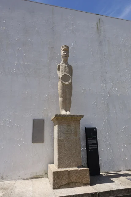
Estátua do Basto in Refojos, with circular shield, pedestal and municipal identification plate.
Estátua do Basto in Refojos · monument photograph© Joseolgonⓘ

A figure can tell a time change.

Read here and view sources

The Basto and the warrior of Santa Comba are presented in the Archaeological Letter as examples of statues of Galaic warriors. Municipal reading relates these figures to the ritual importance of the warrior function during a period of transformation of communities. The Charter also relates this ritual function to gold torques, whose provenance of the area of Cavez presents as hypothesis. In the same table of change, it refers to open agricultural occupations, such as Abadim, and honorary inscriptions. Romanization does not just appear in monuments: it involves settlement, practices and forms of representation.

See Fact sheet: Estátua do Basto
Source and context

Archaeological Letter of Cabeceiras de Basto — Protohistory and Romanization

Accessed: . Editorial summary; the date of consultation is not the date of the facts.
Documented history · 1514

Two outcasts, seven days

October 1514 left two marks on the territory.

Includes an activity to try →Explore: Abadim: documents and marks in place →
Read here and view sources

Manuel I granted the foral of Cabeceiras in 5 October 1514 and that of Vadym, today Abadim, in 12 October. Seven days separate the documents: the administrative history of the territory goes through more than one place.

But what was the point of reviewing the outsiders? The Tombo Tower exhibition explains the general context: there were complaints about outdated charges, coins and weights and old texts difficult to interpret. Manueline reform sought to review these documents. Local dates of 1514 belong to this broader movement; it does not mean that the settlements began to exist that year.

The work also required registration and preservation. The same exhibition describes the preparation in triplicate: one copy for the chamber, one for the landlord of the rights and another for the Tower of the Tombo. This general explanation helps to understand why an administrative document could have several copies. It does not identify here the whereabouts of each copy of the two local forals.

In 5 October 2024, Casa do Tempo received a tertulia over the 510 years of the foral, with José Viriato Chapel and Porfirio Correia. The municipal news recalls the two documents and their importance for the administrative organization. The celebration is a gateway to history; it does not replace the reading of the forals themselves.

Words in this story: see explanations →
Source and context

Municipality — celebration of fora, published in 07/10/2024

DGLAB / Torre do Tombo and Casa de Bragança Foundation — O Foral Novo: records that tell stories, pp. 2 and 4 PDF

Accessed: . Editorial summary; the date of consultation is not the date of the facts.
Refojos · art and architecture

Two organs, one of them mute

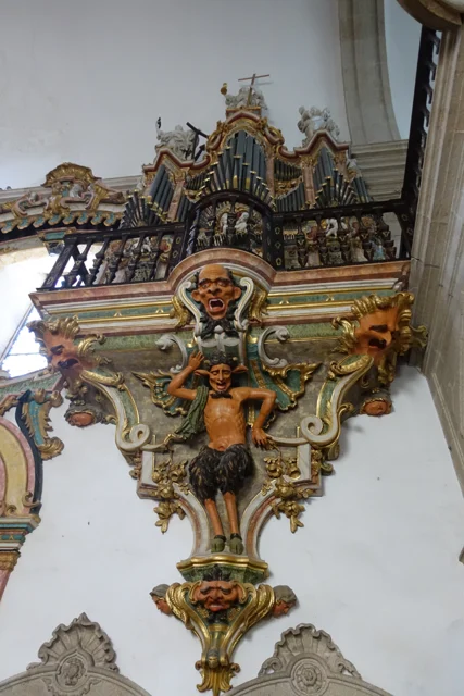
Organ with tubes and golden cut, on carved figures and decorative faces.
View of the organ and the decoration that sustains it, photographed in 2016. The image does not determine which of the two organs is the mute.
Photography: Joseolgon · CC BY-SA 4.0
About this photograph

Date given at source: . Source consulted in 2026-11-07. EXIF orientation, proportional resizing and WebP conversion; no retouching or clipping of the file.

Request removal or correct the photo credit

See more 2 photos and details
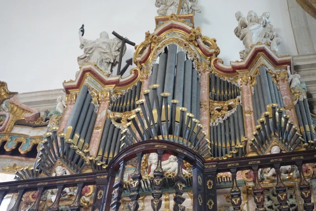
Organ tubes at different heights, surrounded by golden cut and light sculptures.
Details of the tubes, cut and sculptures of the organ in 2016.
Photography: Joseolgon · CC BY-SA 4.0
About this photograph

Date given at source: . Source consulted in 2026-11-07. EXIF orientation, proportional resizing and WebP conversion; no retouching or clipping of the file.

Request removal or correct the photo credit

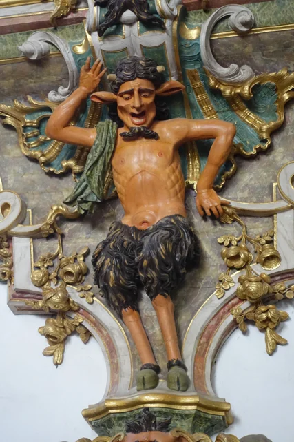
A figure carved with horns, pointed ears and fur-covered legs between golden elements.
Details of a figure carved under the organ in 2016.
Photography: Joseolgon · CC BY-SA 4.0
About this photograph

Date given at source: . Source consulted in 2026-11-07. EXIF orientation, proportional resizing and WebP conversion; no retouching or clipping of the file.

Request removal or correct the photo credit

An invitation to look beyond the facade.

Includes an activity to try →Explore: The pulpits had more than one step. →
Read here and view sources

The municipal description identifies two lateral organs, being a mute. The visual symmetry of the church does not correspond, therefore, to two sound instruments. Next to the entrance appear frowns; later, the wood creates another surprise effect.

The two pulpits are painted brown to imitate marble and partially golden. The fountain places the execution in 1777–1780 and the painting and browning in 1786–1789. Shape, material and finishing count different stages of the same work. This patrimonial description does not confirm the current functioning of the organ.

The choir adds another reading of the wood: the Municipality describes a brown chair, of 1767–1770, organized in two levels and in the shape of U. São 45 seats, with the place of the abbot to the center. The disposition helps imagine a community gathered, instead of looking at each chair separately.

At the top, the circular zimbarium is accompanied by interior and exterior balconies. The description identifies the twelve apostles and, on the top, St. Michael. From furniture to silhouette, they change the scale and the observation point. The photographs of this reading show details of the organ; they do not document all these elements.

Words in this story: see explanations →See Fact sheet: Mosteiro de São Miguel de Refojos
Source and context

Municipality — history and art of Mosteiro de São Miguel de Refojos

Accessed: . Editorial summary; the date of consultation is not the date of the facts.
Arco de Baúlhe · archaeological interpretation

Before the rails, a castro

The Arc also has a much older story.

Includes an activity to try →Explore: How did the settlement change? →
Read here and view sources

During the Romanization, the villages of the region did not all follow the same path. The Archaeological Letter suggests that the small castro of the Arco de Baúlhe had lost inhabitants, while Chacim gained centrality. It also refers to the expansion of the agricultural occupation to lowlands. This reading helps to imagine a changing territory, but does not provide a certain date for the abandonment of the castro of the Arc.

The Charter situates these changes in the process begun in the second half of the first century before Christ. The transformation was not limited to houses: it also changed the relationship between settlements, fields and centers of power. Chacim appears as a place of population concentration and renewal of spaces, while the Arc is presented as a possible example of emptying.

The Mó de Cima materials in Chacim are used to support the agricultural occupation of the lowlands. Later, the text highlights open facilities of the couple type, such as Abadim. Read together, these clues show a change in the organization of the territory; they do not allow to draw a single displacement of inhabitants between two points, nor date all changes in the same year.

Words in this story: see explanations →Getting to know the parish
Source and context

Archaeological Letter of Cabeceiras de Basto — Protohistory and Romanization

Accessed: . Editorial summary; the date of consultation is not the date of the facts.

Abadim · prehistory

The stone also kept drawings

Marmoirals gather ancient tombs and engravings.

Includes an activity to try →
Read here and view sources

In Marmoirais, Abadim, mammoths and granite outcrops with engravings form an archaeological set. The inventory proposes the second or first millennium before Christ, comparing ceramics, engraved motifs and similar sets of the Northwest. Dating results from this interpretation. The name Marmoirais is also related in the source with the tumular memory of the place: the landscape can keep clues in the vestiges and names.

The inventory distinguishes conservation and interpretation: it describes the whole as poorly preserved and admits that the Mamoa 5 can remain intact. It proposes cyst-type funeral structures, without presenting this hypothesis as a confirmed excavation.

The tombs and engravings are different traces, gathered in the same landscape. Reading ceramic materials and comparison with other sets help to propose chronology, but do not automatically reveal the meaning of each recorded motif.

Words in this story: see explanations →Getting to know the parish
Source and context

Municipality — archaeological inventory, interpretations and chronologies

Accessed: . Editorial summary; the date of consultation is not the date of the facts.

Rio Douro · archeology and oral tradition

The village that stayed in memory

The traces of the Old Village of Toninha count for another time.

Includes an activity to try →Explore: Other clues in the territory →
Read here and view sources

In the Old Village of Toninha, the municipal inventory proposes occupation between the 13th and 16th centuries. It compares the constructive remains with other serran settlements, including examples in Lindoso and the abandoned village of Juriz in Montalegre. Already the plague that would have caused the people to leave belongs to the popular tradition. They are different paths to know the place: comparing buildings and collecting memories.

There is a third clue: the Investigations of 1258. The inventory proposes that the village may correspond to one of the ten couples then assigned to Juguelhe. It is a probable identification presented by the author, not an equivalence demonstrated. Comparisons with other places help to formulate this interpretation.

Imagine three cards on the table: the buildings, the document of 1258 and the narrative of the plague. Each opens a different question. What forms are repeated in other villages? What places appear in the document? What explanation conveyed the tradition? The discovery begins by crossing these clues without confusing them.

Getting to know the parish
Source and context

Municipality — Old village of Toninha: proposed chronology, parallels and inquiries of 1258

Accessed: . Editorial summary; the date of consultation is not the date of the facts.

Built heritage · St Nicholas

Three houses, three details

A chapel, a staircase and a portal to read architecture.

Includes an activity to try →
Read here and view sources

Three houses, three details to repair. In Casa da Taipa, the municipal presentation highlights the chapel of Nossa Senhora da Conceição, a quintentist moth. In Casa da Breia, it describes the staircase with volutes on the stone rail, maintaining as uncertain the nineteenth century attribution of the building.

In Casal da Fonte, the highlight goes to the portal with coat of arms and baroque decoration of the late 18th century. Compare chapel, staircase and portal helps to discover different ways to compose a solarenga house. These references do not presuppose access to the interior of the properties.

Words in this story: see explanations →Getting to know the parish See Fact sheet: Casa da Breia See Fact sheet: Casa da Taipa e Capela da Senhora da Conceição
Source and context

Municipality — Cabeceiras de Basto (São Nicolau)

Accessed: . Editorial summary; the date of consultation is not the date of the facts.

Uz · Gondiães e Vilar de Cunhas

Stone on the walls, colme on the roof

At Uz, the materials also tell the story of the mountains.

Includes an activity to try →Explore: From houses to materials →
Read here and view sources

The municipal presentation of the village describes stone houses and some stalk covers. It also recalls the name Casal da Urzeira, associated with the heather of the hills. There are two ways to read the connection between the village and the landscape: in the materials of the houses and in the memory of the name. The same description associates the village with agriculture, animal husbandry and the work of flax and wool. The portrait helps relate houses, fields and crafts. It's an asset presentation, without confirming how many hives remain today.

See Fact sheet: Uz
Source and context

Municipality — Village Guide of Serra da Cabreira: landscape, work and heritage

Accessed: . Editorial summary; the date of consultation is not the date of the facts.

St Nicholas · Archaeological interpretation

The floor also kept reserves

In Cham Lameiras, traces tell more than a story.

Read here and view sources

The municipal inventory interprets part of the set as an area of housing and storage with fossas. It distinguishes it from the funeral monuments and admits possible old agricultural terraces. The proposed dating points to the second or first millennium before Christ: an archaeological reading of different marks on the ground.

The inventory separates several cores. Some correspond to funeral monuments with an elevation of land and a chamber; another is interpreted as housing and storage space. The possible area of agricultural terraces is still a third reading. Gathering everything under a single name does not mean that each brand had the same function.

The chronological proposal is based on ceramics and the comparison with similar sets of the Northwest. It is a way of approaching the remains of a period without giving them an exact year. To explore the set, it begins with three questions: where was it inhabited, where was it kept reserves and where was it buried?

Getting to know the parish
Source and context

Municipality — archaeological inventory, interpretations and chronologies

Accessed: . Editorial summary; the date of consultation is not the date of the facts.

Rio Douro · archaeological interpretation

A village drawn on the hillside

In Monte do Castelo, relief is part of history.

Read here and view sources

The municipal inventory proposes the existence of a small fortified village of the first millennium before Christ. The interpretation is based on the platforms of the land and on the position over an irrigated area. It is not necessary to imagine a medieval castle: here, the word of the toponym accompanies traces of another era.

The small elevation and regular platforms are two clues used in the interpretation. The position allows mastering an irrigated floor extending north. The argument thus combines the form of the land with the relationship between the village and the surrounding area; the toponym alone does not solve dating.

Getting to know the parish
Source and context

Municipality — archaeological inventory, interpretations and chronologies

Accessed: . Editorial summary; the date of consultation is not the date of the facts.

Chacim · interpretation of romanization

Between the mountain and the valley, the settlement changed

Romanization also changed the relationship between the mountain and the fields.

Explore: What clues do this change tell? →
Read here and view sources

Romanization did not have the same effect on all villages. The Archaeological Letter places changes in the second half of the 1st century before Christ: Chacim will have strengthened its centrality, while the small castre of Arco de Baúlhe seems to have lost inhabitants. The text presents an interpretation of traces, not a census of movements.

In Chacim, Mó de Cima’s materials are associated with the occupation and cultivation of nearby lowlands. Later, the description also points to open agricultural establishments, such as the couple identified in Abadim. History is therefore not limited to abandoning the highlands: it involves new centers and different ways of occupying the fields.

The same source relates cultural transformation to sculptures of warriors and honorific inscriptions. They are clues of different natures: one helps to think about social representation, another allows to read signs of Roman practices. When exploring these stories, it is worth asking whenever trace supports each interpretation.

Getting to know the parish
Source and context

Archaeological Letter of Cabeceiras de Basto — Protohistory and Romanization

Municipality — archaeological inventory, interpretations and chronologies

Accessed: . Editorial summary; the date of consultation is not the date of the facts.

Pedraça · Medieval documentation

Pedraça already had another name written

In the 1258 inquiries, it appears as Pedraços.

Includes an activity to try →
Read here and view sources

The municipal presentation recovers this ancient form of the name. It is a small window on medieval documents: the land we know today may appear otherwise written in the sources. The reference allows to situate Pedraça in the registry of 1258, without transforming this date at the beginning of the settlement.

Pedraços and Pedraça are two forms that are worth putting side by side. A written name is also a clue to look for documents: if we search only the current spelling, we can let old references slip away. The municipal presentation provides this variant, but it does not explain here when or why the spelling changed.

The same care applies to the names of the houses. In Casa do Paço, the municipal presentation draws attention to the toponymy. The name can open an investigation; alone, it does not identify a construction date or the function that a building had in all times.

Getting to know the parish
Source and context

Municipality — Pedraça, history and heritage

Accessed: . Editorial summary; the date of consultation is not the date of the facts.

Torinheiras · reading of the territory

Rocks that mark a division

Bull's Marks help you read the boundaries of the territory.

Read here and view sources

In the description of the trail, the Municipality presents these ancient landmarks as testimonies of the division between Cabeceiras de Basto and Montalegre, and between Minho and Trás-os-Montes. They are a concrete way to find in the landscape a border that we usually see only drawn on the map.

Getting to know the parish See Fact sheet: Trilho de Torrinheiras
Source and context

Municipality — Trilho de Torrinheiras, altitude, landmarks and landscape

Accessed: . Editorial summary; the date of consultation is not the date of the facts.

Bucos · testimony of 1758

A chapel shortened the distance

In Casares, getting to church was a practical matter.

Includes an activity to try →
Read here and view sources

In the memory of 22 May 1758, the chapel of Santa Maria, in Casares, served to administer the sacraments to the residents, far from the parish church. The distance helped explain the distribution of places of worship.

The vicar António Alves Teixeira also mentions Santa Ana, in Carrazedo, administered by Manuel Gomes Martins. They are references of the document, without confirmation of access or current status.

The parish church was located in the place of Bucos, which the vicar presented as the most populous of the parish. In addition, he named Vila Boa, Carrazedo and Casares. This set of places helps to understand why a single church did not respond in the same way to the needs of all residents.

The document also distinguishes who administered each chapel: in Casares, the commander; in Carrazedo, Father Manuel Gomes Martins. Place, invocation and administration are three different clues. The function of administering sacraments because of the distance is explained to Casares; it should not be automatically attributed to all the chapels mentioned.

Getting to know the parish
Source and context

Municipality — Parish memories of Bucos (1758)

Accessed: . Editorial summary; the date of consultation is not the date of the facts.

Alvite · testimony of 1758

Six chapels, different responsibilities

The estate also had a care organization.

Includes an activity to try →
Read here and view sources

The memory of Alvite enumerates six chapels in 1758. Saint Antonino belonged to the house and fifth with that name; Good Order was next to the House of Alvimento; the Holy Family, next to the House of the Tower. These three are presented as private.

The others were São Mamede, in Petimão, Santa Catarina, on the homonymous hill, and São Sebastião, in place of the Chão. The text assigns burdens to the customers, but saves St Mamede: there were the convent of Refojos and the abbot of St Clement as midwives. The word factory arises linked to these maintenance responsibilities, not to an industrial installation. These are 1758 bonds, without establishing current property or access.

Words in this story: see explanations →Getting to know the parish See Fact sheet: Casa e Quinta do Alvação See Fact sheet: Casa da Torre de Alvite See Fact sheet: Capela de Santa Catarina de Alvite
Source and context

Basto Land Museum — Parish Memories of 1758: Alvite

Accessed: . Editorial summary; the date of consultation is not the date of the facts.

Heritage of Abadim

A tower to look slowly

Tower of Abadim, with yellow crowning and stone constructions around.
Tower of Abadim · yellow crowning and surrounding constructions.© Joseolgonⓘ

History is also read in windows and corners.

Explore: Read the marks of power and time →
Read here and view sources

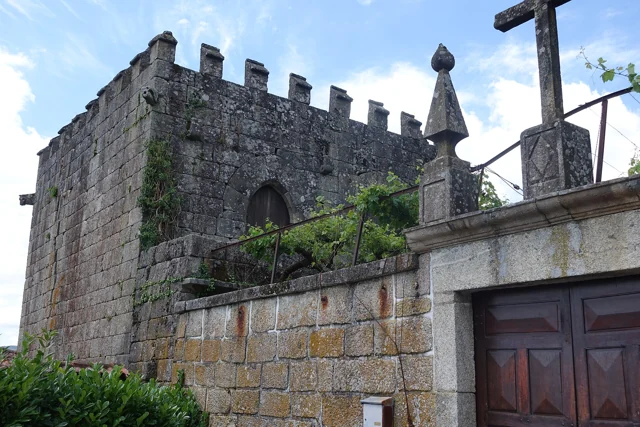
The Tower of Abadim has battlements at the top and gargoyles with animal shapes in the corners. António P. Dinis highlights the settery, the broken arch doors and, inside, conversationals next to the windows. It proposes a construction of the sixteenth century, perhaps from the foral period, without setting an exact date.

The memory of 1758 places the tower in the middle of the Village of the Tower and states that it did not suffer ruin in the earthquake of 1755. The same document describes Abadim with ordinary judge and Chamber, in an organization proper to the former Couto. Reading architecture and administration together helps to understand the importance of the building; the interior description does not confirm current access.

The text of António P. Dinis distinguishes the probable place of the medieval manor from the quintentist construction described today. It is not necessarily the same building preserved without change. The designation Casa do Tronco accompanies the hypothesis that here the justice and the chain of trust functioned.

In the memory of 1758, the election of the ordinary judge and of the House was presided over by the donate. The document also refers to the intervention of the Guimarães magistrate in correction or new scope. Thus, the existence of own organs should not be confused with an administration without relations with other authorities.

Words in this story: see explanations →See Fact sheet: Torre de Abadim / Casa do Tronco
Source and context

Basto Land Museum / António P. Dinis — Tower of Abadim, 17/01/2018

Municipality — Parish memories of Abadim, José Antunes, 22/05/1758

Accessed: . Editorial summary; the date of consultation is not the date of the facts.

Heritage of Abadim

A star in the pillory

Details of the Pelourinho de Abadim in granite
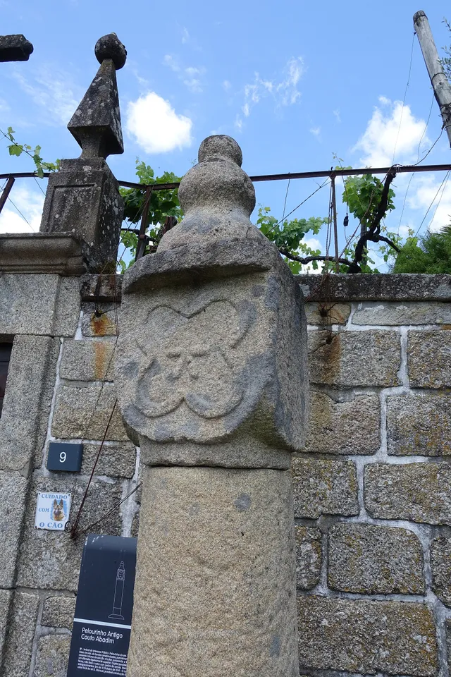
Details of Pelourinho de Abadim. The star described in the text is not visible on this face.© Joseolgonⓘ

A small monument holds a history of autonomy.

Read here and view sources

The pillory of Abadim seems simple at first glance: a smooth column of granite, a cubic capite and a pear-shaped shot. But on one side you find a five-pointed star inside a four-lobe frame. The Museum links the monument to the administrative and judicial autonomy of the former Couto, extinguished in 1836. The Museum brings its construction closer to the foral of 1514, but the record of the Cultural Heritage warns that dating is difficult and that the piece can be quite later. The detail of the star invites you to look again at a piece that would easily go unnoticed.

The official record describes four faces on the capital: three undecorated and one with the star. This helps to understand why a photograph from another side may not show the best known reason. The record places the monument next to the portal of the House of Tower of Tronco and documents the classification as Public Interest Property in 1933. The date of protection is not the date of construction.

The foral, the stone age and the patrimonial classification answer different questions. Instead of automatically assigning ‘1514’ to the entire monument, compare the described form, the proposals for dating and the documents that changed its status.

Words in this story: see explanations →See Fact sheet: Pelourinho de Abadim
Source and context

Basto Land Museum / António P. Dinis — Pelourinho de Abadim, 26/01/2018
Accessed:

Cultural heritage — Pelourinho de Abadim, record 341971, historical-artistic note
Accessed:

Editorial summary; the date of consultation is not the date of the facts.

History of Ponte de Cavez

Five arches, more than a while

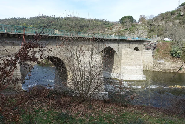
Ponte de Cavez on the river Tâmega, with stone arches, board and wooded banks.
Partial view of the Ponte de Cavez over the Tâmega.© Joseolgonⓘ

An old bridge didn't stop in history.

Includes an activity to try →Explore: A crossing, several seasons →
Read here and view sources

Three broken central arches and two perfect back, next to the banks: the Ponte de Cavez brings together different shapes and times. The Museum located the medieval construction in the second half of the 13th century, at the service of the road between Braga and Vila Pouca de Aguiar.

The source attributes the round arches to the works of Philip II's reign and mentions a landmark of 1599. In the 19th century, the road between Fafe and Vila Pouca de Aguiar brought the enlargement of the board. Watching the bridge is looking for changes to an ancient crossing.

According to the Museum, the stone bridge replaced a previous wooden, then degraded. The construction is attributed to Frei Lourenço Mendes, Dominican who gathered alms for the work; the museological text mentions testimonial legacies as support of this connection. The crossing thus involves materials, paths and ways to finance a collective work.

Words in this story: see explanations →See Fact sheet: Ponte de Cavez
Source and context

Land Museum of Basto — Ponte de Cavez, 27/02/2022

Municipality of Cabeceiras de Basto — Parish memories of 1758: Cavez

Municipality — conclusion of rehabilitation of Ponte de Cavez, 30/04/2019

Accessed: . Editorial summary; the date of consultation is not the date of the facts.

Local legend · Ponte de Cavez

The voice that had built above

Ponte de Cavez on the river Tâmega, with stone arches, board and wooded banks.
Ponte de Cavez on the Tâmega · the monument to which legend refers.© Joseolgonⓘ

Around the bridge, memory also invented paths.

Includes an activity to try →
Read here and view sources

The legend published by the Museum makes the masons try to build the bridge in Vila Franca and then by the Poço das Laranjeiras. In both places, a supernatural voice sent up the river. Tradition attributed it to Saint Bartholomew.

On the third attempt, the narrative places the work next to the chapel. It is a story about the memory of the place, not documentary proof of the choice of the site or an itinerary to look for the episodes.

In another passage of the tradition collected by the Museum, the food of the builders gains a miraculous explanation: there are sources of water, wine and olive oil and fish appear in the river. The narrative associates the effort of construction to religious protection. Reading it alongside the history of the works allows to know two different ways of telling the same place.

See Fact sheet: Ponte de Cavez See Fact sheet: Capela de São Bartolomeu de Cavez
Source and context

Land Museum of Basto — Ponte de Cavez, 27/02/2022

Accessed: . Editorial summary; the date of consultation is not the date of the facts.

Regional rail link · Celorico bridge Basto

To get to the Arc, the line needed to cross another valley

The history of the Cabeceiras train also passes through the neighboring municipality.

Includes an activity to try →Explore: A bridge ready, an uncompleted connection →
Read here and view sources

Before reaching Cabeceiras, the line had to cross the valley of the river of Veade. The bridge of Matamá is in the Union of the Freguesies of Veade, Gagos and Molares, in Celorico of Basto. According to the Museum, its six granite arches form a structure about 190 meters long and 52 meters high.

The report distinguishes two moments: the opening of the bridge in 5 June 1936, and the entry into railway use in 15 January 1949, with the opening of the Celorico section of Basto–Arco de Baúlhe. Having the bridge built did not immediately mean having trains arriving at the Arc. This regional history helps to realize the time needed to complete the connection.

The report of the Museum attributes the responsibility of the work to engineers Jorge Vieira Bastian and Manuel Gonçalves Costa. The dimension of the structure helps to realize the challenge of taking the railway through the valley; the chronology allows to separate this work from the entry into service of the complete connection.

Source and context

Basto Land Museum / Pedro T. Gonçalves — Matamá Railway Bridge, 28/07/2026

Municipality — Land Museum of Basto: a journey through the history of the region, pp. 28–29

Accessed: . Editorial summary; the date of consultation is not the date of the facts.

Arco de Baúlhe · history of the Municipal Library

In the Arch, the books won home in 2005

A library also holds meetings and discoveries.

Read here and view sources

The Biblioteca Municipal Dr. António Teixeira de Carvalho was inaugurated in 2005, at the Arco de Baúlhe Basic School. The municipal presentation describes two reading rooms and an auditorium, as well as work and meeting spaces. It also recalls activities such as the time of the tale, workshops, literary contests, cinema and exhibitions. The history of the equipment shows how the reading intersects with other forms of cultural participation. To plan a visit, see the site chart.

Source and context

Municipality — Biblioteca Municipal Dr. António Teixeira de Carvalho: opening in 2005

Accessed: . Editorial summary; the date of consultation is not the date of the facts.

Line of Tâmega · object presented by the Museum in June 2024

The last light told a story

A red light signaled that the train was going full.

Includes an activity to try →Explore: Two lights, different tasks →
Read here and view sources

The last vehicle of the train carried important information. The Museum features a red-light taillight, used at night in the last carriage or wagon to indicate that the composition was complete. Its function was to signal, not to illuminate the path ahead of the locomotive.

The registration N.1 AND POST. OF THE BOOK connects the object to the station of Livração, in the line of the Valley of Tâmega. Reading the piece implies joining three clues: the color of the light, the position on the train and the inscription associating it to a place.

This small object shows that the railway history is also made of discrete signs and tasks. The presentation of the Museum, published in June 2024, describes the use and station to which the lighthouse was affected; it does not indicate a date of manufacture for the piece.

Words in this story: see explanations →
Source and context

Land Museum of Basto — Taillight “N.1 AND POSTO. FREEDOM”, 2024-06-28

Accessed: . Editorial summary; the date of consultation is not the date of the facts.

Faia · religious organization in 1758

A church linked to the Grand Prior of Crato

The history of a parish also goes through distant connections.

Read here and view sources

In the reply of 1758, the abbot of the Faia writes that his presentation belonged to the infant D. Pedro, as Grand Prior of Crato. He also refers to the intervention of the provisor of the city of Porto in its collation. These details show that the local religious organization involved authorities beyond Cabeceiras. The account describes the form of provision of the office at that time; it does not mean that the Faia belonged to the municipality of Crato or Porto.

The same answer estimated the income of the benefit in 450 réis. This value belongs to the description of the institution and should not be presented as a current salary or converted directly into a price today. Dealing with the altars and chapels, adds a layer to the history: besides the building and the devotions, there was an organization of positions and incomes.

Getting to know the parish
Source and context

Municipality of Cabeceiras de Basto — Parish memories of Faia, 23/05/1758, replies 8, 20 and 21

Accessed: . Editorial summary; the date of consultation is not the date of the facts.

Alvite · heritage and landscape deployment

A chapel leaning against the stone

In Santa Catarina, the construction finds the penedia.

Includes an activity to try →Explore: One chapel, three scales →
Read here and view sources

The municipal presentation highlights a particularity of the chapel of Santa Catarina de Alvite: it is encrusted in a penedia. The encounter between rock and construction gives a clue to look at the heritage beyond the facade.

The source identifies this relationship with the place, but does not provide here a construction date or a visiting time. The chapel form gathers the available documentary information.

The memory of 1758 already named Santa Catarina in the hill with this name, among six chapels of the parish. The two sources answer different questions: the old document places it in a network of places of worship; the municipal presentation draws attention to the relationship between construction and rock. This presence in the report does not date the external form that the photograph shows.

See Fact sheet: Capela de Santa Catarina de Alvite
Source and context

Municipality — landscape of Alvite e Passos

Basto Land Museum — Parish Memories of 1758: Alvite

Accessed: . Editorial summary; the date of consultation is not the date of the facts.

Cunhas · heritage and legends in the municipal guide

A village between a manor and two legends

In Cunhas, the built heritage finds the oral tradition.

Includes an activity to try →
Read here and view sources

The municipal guide of the villages highlights in Cunhas a nucleus of concentrated old houses and the manor of Teixeiras Pereiras. It is a reference to the architecture of the village, without indication of access to the interior of the building.

The same guide tells two legends: one associates the name of Cunhas to a soldier called Cunha de Pau, linked to the fight against the Moors; another says that Santa Senhorinha had house in the locality. They are narratives of popular memory. The publication does not present them as proven events nor allows to locate a house of the saint.

Source and context

Municipality — Village Guide of Serra da Cabreira: landscape, work and heritage

Accessed: . Editorial summary; the date of consultation is not the date of the facts.

Cavez · settlement and devotion in 1758

Eight places and six chapels

In Cavez, an ancient list draws relations between villages, residents and monasteries.

Includes an activity to try →
Read here and view sources

In 25 of May 1758, the vicar Manuel Pacheco da Cunha numbered eight places: Cavez, Vila Franca, Ponte, Arosa, Rabiçais, Moimenta, Revorça and Parada. He located the church in the middle of the parish and described six chapels. Names help to recognize a hammock; they are not a current list of administrative places.

São Gregório, in Vila Franca, São Mamede, in Arosa, and Santa Maria Magdalena, in Moimenta, were attributed to the abbot of Pombeiro, with its maintenance linked to the Benedictine congregation of Tibães. São Bartolomeu, on the Bridge, had as patron João Correia, of Guimarães. In São Caetano, in Raviceis at the passage of the chapels, and Santa Luzia, in Revorça, the charge was for the residents. The transcription itself uses the variants Rabiçais and Raviceais.

The report also describes five altars in the matrix and a brotherhood of the Souls. The parish appears as a space of worship and collective organization, with distinct responsibilities. The pilgrimage of São Bartolomeu is mentioned for 23 and 24 of August; they are dates of historical testimony, without functioning as current agenda.

The parish links went beyond the chapels. The vicar wrote that Cavez did not have their own mail and resorted to Raposeira, which was located to a league. He also indicated the absence of fair in the parish. They are clues to think where news arrived and where services were concentrated at that time; they do not describe the current offer nor allow automatically to convert the league into a road distance.

Getting to know the parish See Fact sheet: Capela de São Bartolomeu de Cavez See Fact sheet: Igreja de São João de Cavez e cruzeiro
Source and context

Municipality of Cabeceiras de Basto — Parish memories of 1758: Cavez

Accessed: . Editorial summary; the date of consultation is not the date of the facts.

Outeiro · archaeological inventory published in 2026

Three places, several layers of past

Outeiro is also known through archaeology.

Includes an activity to try →
Read here and view sources

The PDM inventory of 2026 brings together three archaeological references in Outeiro: the Medieval Sepulturas da Mata Santa, the Shelter of the Serra da Penouta and Outeiro of Pena.

The Santa Forest appears as a medieval necropolis. Penouta shelter is attributed to Neolithic/Calcolithic; Outeiro of Pena appears as shelter/atalaya, with the indication Prehistory/Media. These are categories and periods of inventory, not three exact dates of construction.

These entries open a longer story than the explanation of the name of the parish. They do not demonstrate continuous occupation between the indicated periods, nor do they establish a link between the graves and the sculpture of Santa Maria. The documentary reference also does not confirm conditions of visit.

Words in this story: see explanations →
Source and context

Diary of the Republic — Notice No 16185/2026/2, PDM Cabeceiras de Basto, archaeological inventory AQL34–AQL36, p. 92 (29/06/2026)

Accessed: . Editorial summary; the date of consultation is not the date of the facts.

Arco de Baúlhe e Vila Nune · municipal heritage description

The Triangle Facing Water

A detail of the Old Bridge helps to find out which side the river comes from.

Read here and view sources

At Ponte Velha de Arco de Baúlhe, a semicircular arch holds the board over the Gold River. The municipal description attributes the construction to the 18th century.

The triangular seak is upstream from where the water comes from. This detail allows you to read the bridge beyond its silhouette. The shape of the arch itself does not prove a Roman origin.

Words in this story: see explanations →See Fact sheet: Ponte Velha de Arco de Baúlhe
Source and context

Municipality — Cultural heritage, bridges of Arco de Baúlhe and Moimenta

Accessed: . Editorial summary; the date of consultation is not the date of the facts.

YOUR LOCAL GUIDE

What would you like to discover?

Take a closer look.