Discover Cabeceiras de BastoFree independent guide
ViveCabeceirasYOUR GUIDE TO CABECEIRAS
ENEnglish
SearchSaved

Story

Choose a story to start with. You can change the subject or fine tune the search.

21 stories · Time travel · Search: pedra

Time travel

Documents, details and traditions: there is more to discover than a date on a stone.

Choose a story · 21
Pedraça · Medieval documentation

Pedraça already had another name written

In the 1258 inquiries, it appears as Pedraços.

Includes an activity to try →
Read here and view sources

The municipal presentation recovers this ancient form of the name. It is a small window on medieval documents: the land we know today may appear otherwise written in the sources. The reference allows to situate Pedraça in the registry of 1258, without transforming this date at the beginning of the settlement.

Pedraços and Pedraça are two forms that are worth putting side by side. A written name is also a clue to look for documents: if we search only the current spelling, we can let old references slip away. The municipal presentation provides this variant, but it does not explain here when or why the spelling changed.

The same care applies to the names of the houses. In Casa do Paço, the municipal presentation draws attention to the toponymy. The name can open an investigation; alone, it does not identify a construction date or the function that a building had in all times.

Getting to know the parish
Source and context

Municipality — Pedraça, history and heritage

Accessed: . Editorial summary; the date of consultation is not the date of the facts.
Cabeceiras · archaeological interpretation

Warriors who stood on the stone

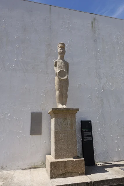
Estátua do Basto in Refojos, with circular shield, pedestal and municipal identification plate.
Estátua do Basto in Refojos · monument photograph© Joseolgonⓘ

A figure can tell a time change.

Read here and view sources

The Basto and the warrior of Santa Comba are presented in the Archaeological Letter as examples of statues of Galaic warriors. Municipal reading relates these figures to the ritual importance of the warrior function during a period of transformation of communities. The Charter also relates this ritual function to gold torques, whose provenance of the area of Cavez presents as hypothesis. In the same table of change, it refers to open agricultural occupations, such as Abadim, and honorary inscriptions. Romanization does not just appear in monuments: it involves settlement, practices and forms of representation.

See Fact sheet: Estátua do Basto
Source and context

Archaeological Letter of Cabeceiras de Basto — Protohistory and Romanization

Accessed: . Editorial summary; the date of consultation is not the date of the facts.

Abadim · prehistory

The stone also kept drawings

Marmoirals gather ancient tombs and engravings.

Includes an activity to try →
Read here and view sources

In Marmoirais, Abadim, mammoths and granite outcrops with engravings form an archaeological set. The inventory proposes the second or first millennium before Christ, comparing ceramics, engraved motifs and similar sets of the Northwest. Dating results from this interpretation. The name Marmoirais is also related in the source with the tumular memory of the place: the landscape can keep clues in the vestiges and names.

The inventory distinguishes conservation and interpretation: it describes the whole as poorly preserved and admits that the Mamoa 5 can remain intact. It proposes cyst-type funeral structures, without presenting this hypothesis as a confirmed excavation.

The tombs and engravings are different traces, gathered in the same landscape. Reading ceramic materials and comparison with other sets help to propose chronology, but do not automatically reveal the meaning of each recorded motif.

Words in this story: see explanations →Getting to know the parish
Source and context

Municipality — archaeological inventory, interpretations and chronologies

Accessed: . Editorial summary; the date of consultation is not the date of the facts.

Uz · Gondiães e Vilar de Cunhas

Stone on the walls, colme on the roof

At Uz, the materials also tell the story of the mountains.

Includes an activity to try →Explore: From houses to materials →
Read here and view sources

The municipal presentation of the village describes stone houses and some stalk covers. It also recalls the name Casal da Urzeira, associated with the heather of the hills. There are two ways to read the connection between the village and the landscape: in the materials of the houses and in the memory of the name. The same description associates the village with agriculture, animal husbandry and the work of flax and wool. The portrait helps relate houses, fields and crafts. It's an asset presentation, without confirming how many hives remain today.

See Fact sheet: Uz
Source and context

Municipality — Village Guide of Serra da Cabreira: landscape, work and heritage

Accessed: . Editorial summary; the date of consultation is not the date of the facts.
Pedraça · Parish memories of 1758

A Pedraça call to Coimbra

In 1758, the parish priest's choice pointed out to the council.

Includes an activity to try →Explore: Read a document, ask questions →
Read here and view sources

The parish memory describes the matrix dedicated to Santa Marinha and states that the rector was presented by the rector of the College of São Jerónimo de Coimbra. This historical link shows how a small parish was part of relations that surpassed the lands of Basto.

The same transcript places Pedraça at the end of Cabeceiras de Basto and in the district of Guimarães. It records 96 fires and 322 souls of communion, in addition to a congruity of 50 thousand réis for the rector. They are categories of the document: fires are not people, and souls of communion do not automatically equal the total inhabitants.

The numbers and connection to Coimbra show two plans of parish life: the community described and the organization that framed his parish priest. The municipal version identifies the transcription of José Viriato Chapel, published in 2003, from the Memórias of 1758.

The municipal page also distinguishes the account from the references that accompany it: it refers to the memory 296 of the volume 42 and lists an obligation to the Santa Bárbara hermitage factory, of 1624, and another linked to the Blessed Sacrament, of 1722. They are archive clues. The existence of these references does not mean that the full text of the two documents is reproduced on the page, nor transforms 1624 on a date of construction of the chapel.

Words in this story: see explanations →Getting to know the parish See Fact sheet: Igreja paroquial de Pedraça See Fact sheet: Santa Bárbara de Pedraça — capela e miradouro
Source and context

Municipality — Parish Memories of Pedraça (1758), transcript of José Viriato Chapel (2003)
Accessed:

Municipality — Parish Memories of Pedraça, 1758; transcription of José Viriato Chapel (2003)
Accessed:

Editorial summary; the date of consultation is not the date of the facts.
Torinheiras · reading of the territory

Rocks that mark a division

Bull's Marks help you read the boundaries of the territory.

Read here and view sources

In the description of the trail, the Municipality presents these ancient landmarks as testimonies of the division between Cabeceiras de Basto and Montalegre, and between Minho and Trás-os-Montes. They are a concrete way to find in the landscape a border that we usually see only drawn on the map.

Getting to know the parish See Fact sheet: Trilho de Torrinheiras
Source and context

Municipality — Trilho de Torrinheiras, altitude, landmarks and landscape

Accessed: . Editorial summary; the date of consultation is not the date of the facts.
Holy Lady · memory of 1758

Not all bridges were stone

The wood also united the banks.

Read here and view sources

The memory of 1758 lists three wooden bridges in the parish: Vagalhafos, in Quinta de Vila de Lobos; Santa Senhorinha, near the church; and Olela. Names approach the crossings of the farms, the place of worship and the inhabited places.

The same report mentions singing bridges in São Clemente and São Martinho do Arco de Baúlhe. Wood and stone appear, thus, in a single description of the river. The enumeration does not provide construction dates nor proves the survival of structures.

Words in this story: see explanations →
Source and context

Municipality — Memória de Santa Senhorinha, 23/05/1758; transcript of José Viriato Chapel (2003)

Accessed: . Editorial summary; the date of consultation is not the date of the facts.
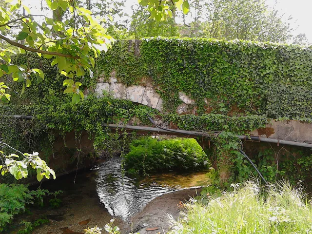
Pedraça · housing

Pedraça is also counted by houses

Beyond the church, there is a housing landscape.

Includes an activity to try →Explore: Houses, persons and work in Pedraça →
Read here and view sources

The history of Pedraça is also read in the houses. The municipal presentation highlights Casa do Paço, Casa de Parada and the houses of the Baron of Basto and Paço de Vila. For Parada, it uses the expression Brazilian taste; for Casa do Paço, it draws attention to the name of the place. They are different clues: one points to architecture, another to the toponymy.

These houses are part of a parish that the Municipality describes as fertile and abundant in water, linked to agriculture and the cultivation of flax. Approaching the housing of the work landscape helps to look at the heritage beyond religious buildings.

The municipal description does not provide construction dates for this set nor identifies those responsible for each work. Nor does the reference to Brazilian taste enough to reconstruct the biography of a owner. The houses are here starting points to know the parish; their inclusion does not presuppose public access.

Words in this story: see explanations →
Source and context

Municipality — parish presentation of Pedraça

Accessed: . Editorial summary; the date of consultation is not the date of the facts.

Alvite · heritage and landscape deployment

A chapel leaning against the stone

In Santa Catarina, the construction finds the penedia.

Includes an activity to try →Explore: One chapel, three scales →
Read here and view sources

The municipal presentation highlights a particularity of the chapel of Santa Catarina de Alvite: it is encrusted in a penedia. The encounter between rock and construction gives a clue to look at the heritage beyond the facade.

The source identifies this relationship with the place, but does not provide here a construction date or a visiting time. The chapel form gathers the available documentary information.

The memory of 1758 already named Santa Catarina in the hill with this name, among six chapels of the parish. The two sources answer different questions: the old document places it in a network of places of worship; the municipal presentation draws attention to the relationship between construction and rock. This presence in the report does not date the external form that the photograph shows.

See Fact sheet: Capela de Santa Catarina de Alvite
Source and context

Municipality — landscape of Alvite e Passos

Basto Land Museum — Parish Memories of 1758: Alvite

Accessed: . Editorial summary; the date of consultation is not the date of the facts.

Cavez · history of the bridge of Moimenta; current conditions not verified

Two seasons on the same bridge

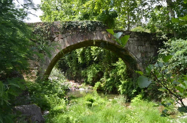
Ponte antiga de Moimenta in Cavez: stone arch over the river, surrounded by vegetation, photographed in June 2020.
Moimenta Bridge, photographed by Pedro at 11 June 2020. A crossing record other than Ponte de Cavez over Tâmega.© Pedroⓘ

In Moimenta, the ancient stone coexists with an intervention of 1990.

Read here and view sources

An ancient bridge can continue to change. The municipality attributes medieval origin to the bridge of Moimenta in Cavez, and describes a single round arch.

In 1990, the passage was extended about one meter: it received a concrete structure on the downstream side and the guards were changed. The photograph allows to begin to observe the crossing; the date of the intervention comes from the documentary description.

Words in this story: see explanations →See Fact sheet: Ponte antiga de Moimenta
Source and context

Municipality — Cultural heritage, bridges of Arco de Baúlhe and Moimenta

Accessed: . Editorial summary; the date of consultation is not the date of the facts.

Arco de Baúlhe · archaeological interpretation

Before the rails, a castro

The Arc also has a much older story.

Includes an activity to try →Explore: How did the settlement change? →
Read here and view sources

During the Romanization, the villages of the region did not all follow the same path. The Archaeological Letter suggests that the small castro of the Arco de Baúlhe had lost inhabitants, while Chacim gained centrality. It also refers to the expansion of the agricultural occupation to lowlands. This reading helps to imagine a changing territory, but does not provide a certain date for the abandonment of the castro of the Arc.

The Charter situates these changes in the process begun in the second half of the first century before Christ. The transformation was not limited to houses: it also changed the relationship between settlements, fields and centers of power. Chacim appears as a place of population concentration and renewal of spaces, while the Arc is presented as a possible example of emptying.

The Mó de Cima materials in Chacim are used to support the agricultural occupation of the lowlands. Later, the text highlights open facilities of the couple type, such as Abadim. Read together, these clues show a change in the organization of the territory; they do not allow to draw a single displacement of inhabitants between two points, nor date all changes in the same year.

Words in this story: see explanations →Getting to know the parish
Source and context

Archaeological Letter of Cabeceiras de Basto — Protohistory and Romanization

Accessed: . Editorial summary; the date of consultation is not the date of the facts.

Bucos · transport in 1758

A small bridge, a long way

Married was in the way of a lot of people.

Includes an activity to try →Explore: Paths that served the life of the village →
Read here and view sources

In Casares, a wooden bridge integrated the real road to Braga and communications with Trás-os-Montes, according to the memory of 1758. Before the movement, the vicar defended building it in stone. It was a request, not the confirmation of a work.

The source distinguishes this passage from small walkways made with a wooden beam, for pedestrians. Different paths responded to different uses.

The passage not only served the village. The vicar describes a public road and very frequented, linking Braga to the term of Basto and Trás-os-Montes. The bridge emerges, as a local point of a larger network. The recommendation to replace it by chanting shows the author to assess a need, besides inventing what existed.

In the same rivers, the water moved mills and was used by farmers in the fields. The crossing, grinding and watering appear in the same portrait of the territory. A bridge can be read by what it allows to do: reach another place, maintain a communication or approximate works separated by water.

Words in this story: see explanations →Getting to know the parish
Source and context

Municipality — Parish memories of Bucos (1758)

Accessed: . Editorial summary; the date of consultation is not the date of the facts.

Rio Douro · archaeological interpretation

A castle you read on the ground

In Eiró, the circular shape and moat tell a story.

Includes an activity to try →Explore: The land and documents →
Read here and view sources

The municipal inventory interprets the vestiges as a fortified motorcycle-type residence from the middle of the 13th century. It relates it to the castle referred to in the 1258 Inquisitions. The circular shape rests on a stone and gravel landfill, surrounded by a moat. The municipality highlights the position over the valley of Rio Douro, link between Refojos and the plateau Barrosão. The reading combines ground and document, without reconstructing the missing building for sure.

The document of 1258 adds a social dimension to the form of the land: according to the municipal interpretation, almost all residents of Santo André of Rio Douro had an annual obligation to move to the castle. The reference links fortification to the community organization, although it does not clarify here all the associated tasks.

The inventory compares construction with examples from Brittany. It is a comparison of forms and techniques, not a proof of the origin of its builders. The location in the middle of the hillside helps to understand the relationship between defense and passage through the valley.

Getting to know the parish
Source and context

Municipality — archaeological inventory, interpretations and chronologies

Accessed: . Editorial summary; the date of consultation is not the date of the facts.

Rio Douro · archeology and oral tradition

The village that stayed in memory

The traces of the Old Village of Toninha count for another time.

Includes an activity to try →Explore: Other clues in the territory →
Read here and view sources

In the Old Village of Toninha, the municipal inventory proposes occupation between the 13th and 16th centuries. It compares the constructive remains with other serran settlements, including examples in Lindoso and the abandoned village of Juriz in Montalegre. Already the plague that would have caused the people to leave belongs to the popular tradition. They are different paths to know the place: comparing buildings and collecting memories.

There is a third clue: the Investigations of 1258. The inventory proposes that the village may correspond to one of the ten couples then assigned to Juguelhe. It is a probable identification presented by the author, not an equivalence demonstrated. Comparisons with other places help to formulate this interpretation.

Imagine three cards on the table: the buildings, the document of 1258 and the narrative of the plague. Each opens a different question. What forms are repeated in other villages? What places appear in the document? What explanation conveyed the tradition? The discovery begins by crossing these clues without confusing them.

Getting to know the parish
Source and context

Municipality — Old village of Toninha: proposed chronology, parallels and inquiries of 1258

Accessed: . Editorial summary; the date of consultation is not the date of the facts.

Built heritage · St Nicholas

Three houses, three details

A chapel, a staircase and a portal to read architecture.

Includes an activity to try →
Read here and view sources

Three houses, three details to repair. In Casa da Taipa, the municipal presentation highlights the chapel of Nossa Senhora da Conceição, a quintentist moth. In Casa da Breia, it describes the staircase with volutes on the stone rail, maintaining as uncertain the nineteenth century attribution of the building.

In Casal da Fonte, the highlight goes to the portal with coat of arms and baroque decoration of the late 18th century. Compare chapel, staircase and portal helps to discover different ways to compose a solarenga house. These references do not presuppose access to the interior of the properties.

Words in this story: see explanations →Getting to know the parish See Fact sheet: Casa da Breia See Fact sheet: Casa da Taipa e Capela da Senhora da Conceição
Source and context

Municipality — Cabeceiras de Basto (São Nicolau)

Accessed: . Editorial summary; the date of consultation is not the date of the facts.

Cavez · Parish memories of 1758

A bridge that deserved praise

Ponte de Cavez on the river Tâmega, with stone arches, board and wooded banks.
Ponte de Cavez · crossing Tâmega© Joseolgonⓘ

In 1758, the Cavez Grand Bridge impressed the parish priest.

Explore: Two shores, several stories →
Read here and view sources

In the parochial memory, the crossing of the Tâmega appears described as a great stone bridge, well worked. The author even considers it the best of that river. The praise belongs to the look of those who wrote: it reveals the importance it attributed to the construction, without functioning as a technical comparison between bridges.

In the same memory, the Tâmega appears as a strong current, especially in winter. The document distinguishes the crossing from the use of water: it describes mills and explains that the river was too deep to water the fields in that stretch. The bridge can be read in this set of relations between margins, displacements and work.

Notice the difference between observing a construction and evaluating it. The existence of the bridge is information; considering it the best is an appreciation. The two say something about the past, but answer different questions.

Getting to know the parish See Fact sheet: Ponte de Cavez
Source and context

Municipality of Cabeceiras de Basto — Parish memories of 1758: Cavez

Accessed: . Editorial summary; the date of consultation is not the date of the facts.

Gondiães e Vilar de Cunhas · memory and landscape

Before Vilar, Vila Seca

Names also keep changes in the territory.

Explore: Three villages, various ways to know →
Read here and view sources

Vila Seca is the former designation of Vilar de Cunhas remembered by the Municipality. The presentation gathers three villages: Vilar, Cunhas and Uz.

It also distinguishes plateau and mountain areas, associated with agriculture and pastoral care. A parish name can therefore cover different settlements and landscapes. The source does not date the change of designation.

The municipal presentation places this territory near Montalegre and Ribeira de Pena. This position helps to understand a landscape that continues beyond the administrative limit: the villages belong to the municipality, but the valleys and relations between places invite also to look at the neighboring territories.

Getting to know the parish
Source and context

Municipality — Gondiães e Vilar de Cunhas, landscape, heritage and crafts

Accessed: . Editorial summary; the date of consultation is not the date of the facts.

Heritage of Abadim

A star in the pillory

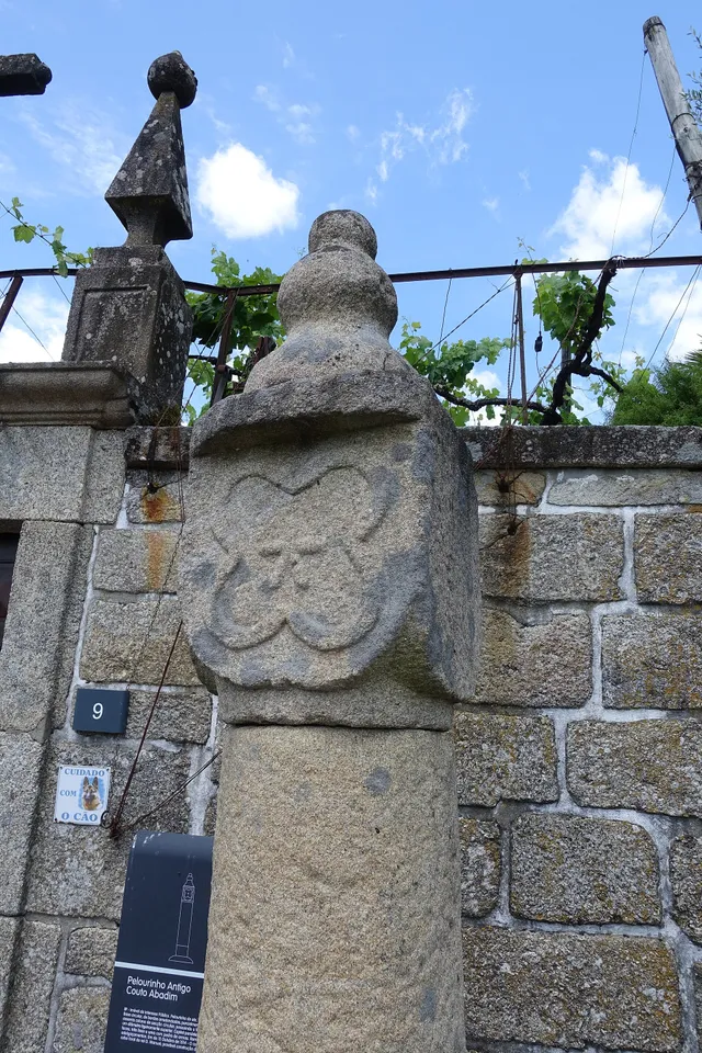
Details of the Pelourinho de Abadim in granite
Details of Pelourinho de Abadim. The star described in the text is not visible on this face.© Joseolgonⓘ

A small monument holds a history of autonomy.

Read here and view sources

The pillory of Abadim seems simple at first glance: a smooth column of granite, a cubic capite and a pear-shaped shot. But on one side you find a five-pointed star inside a four-lobe frame. The Museum links the monument to the administrative and judicial autonomy of the former Couto, extinguished in 1836. The Museum brings its construction closer to the foral of 1514, but the record of the Cultural Heritage warns that dating is difficult and that the piece can be quite later. The detail of the star invites you to look again at a piece that would easily go unnoticed.

The official record describes four faces on the capital: three undecorated and one with the star. This helps to understand why a photograph from another side may not show the best known reason. The record places the monument next to the portal of the House of Tower of Tronco and documents the classification as Public Interest Property in 1933. The date of protection is not the date of construction.

The foral, the stone age and the patrimonial classification answer different questions. Instead of automatically assigning ‘1514’ to the entire monument, compare the described form, the proposals for dating and the documents that changed its status.

Words in this story: see explanations →See Fact sheet: Pelourinho de Abadim
Source and context

Basto Land Museum / António P. Dinis — Pelourinho de Abadim, 26/01/2018
Accessed:

Cultural heritage — Pelourinho de Abadim, record 341971, historical-artistic note
Accessed:

Editorial summary; the date of consultation is not the date of the facts.

History of Ponte de Cavez

Five arches, more than a while

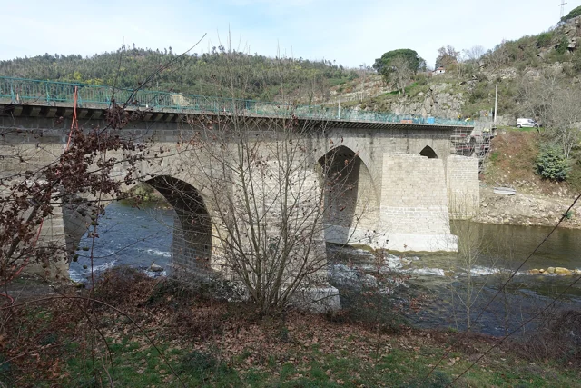
Ponte de Cavez on the river Tâmega, with stone arches, board and wooded banks.
Partial view of the Ponte de Cavez over the Tâmega.© Joseolgonⓘ

An old bridge didn't stop in history.

Includes an activity to try →Explore: A crossing, several seasons →
Read here and view sources

Three broken central arches and two perfect back, next to the banks: the Ponte de Cavez brings together different shapes and times. The Museum located the medieval construction in the second half of the 13th century, at the service of the road between Braga and Vila Pouca de Aguiar.

The source attributes the round arches to the works of Philip II's reign and mentions a landmark of 1599. In the 19th century, the road between Fafe and Vila Pouca de Aguiar brought the enlargement of the board. Watching the bridge is looking for changes to an ancient crossing.

According to the Museum, the stone bridge replaced a previous wooden, then degraded. The construction is attributed to Frei Lourenço Mendes, Dominican who gathered alms for the work; the museological text mentions testimonial legacies as support of this connection. The crossing thus involves materials, paths and ways to finance a collective work.

Words in this story: see explanations →See Fact sheet: Ponte de Cavez
Source and context

Land Museum of Basto — Ponte de Cavez, 27/02/2022

Municipality of Cabeceiras de Basto — Parish memories of 1758: Cavez

Municipality — conclusion of rehabilitation of Ponte de Cavez, 30/04/2019

Accessed: . Editorial summary; the date of consultation is not the date of the facts.

Pedraça · tradition registered by the Municipality

A house between memory and proof

The tradition of the Constable deserves to be counted as tradition.

Includes an activity to try →
Read here and view sources

The Municipality presents as a tradition the narrative of a pickpocket next to the Casa de Pedraça, associated with D. Nuno Álvares Pereira, and the nuptials passed there after the wedding with D. Leonor de Alvim. It is a memory linked to the place; the formulation of the source itself does not transform it into a demonstrated event. Distinguishing the two plans helps to know history without erasing the local imaginary.

See Fact sheet: Casa de Pedraça
Source and context

Municipality — parish presentation of Pedraça

Accessed: . Editorial summary; the date of consultation is not the date of the facts.

Painzela · patrimonial identification without chronology demonstrated

A bridge, a name and a question

Stone bridge of Painzela on a water line, surrounded by vegetation
Ponte de Painzela, photographed by Tommasoandrea. The image allows observing the arch and the water line; it does not determine the time of construction.© Tommasoandreaⓘ

Calling him Roman doesn't solve your age.

Includes an activity to try →
Read here and view sources

The municipal presentation of Painzela includes a photograph identified as Ponte de Painzela and refers to a Roman Bridge among the heritage of the parish. This designation alone does not demonstrate when the bridge was built. The name allows to find the place; dating would require documentation or study of the construction. It is a good question to lead to a reading of the heritage: what do we know by identification and what we still need to investigate?

See Fact sheet: Ponte de Painzela
Source and context

Municipality — parish presentation of Painzela and bridge identification

Accessed: . Editorial summary; the date of consultation is not the date of the facts.

YOUR LOCAL GUIDE

What would you like to discover?

Take a closer look.