Discover Cabeceiras de BastoFree independent guide
ViveCabeceirasYOUR GUIDE TO CABECEIRAS
ENEnglish
SearchSaved

Story

Choose a story to start with. You can change the subject or fine tune the search.

21 stories · Time travel · Search: datas

Time travel

Documents, details and traditions: there is more to discover than a date on a stone.

Choose a story · 21
Abadim · architecture and interpretation of registrations

Two dates don't count the whole house

In the House of Ramada, the doors hold clues from different times.

Includes an activity to try →
Read here and view sources

António P. Dinis highlights, in Abadim, the Casa da Ramada, with an armoriated portal, a thorn, a threshing floor and a porch. Refers 1678 in a baker's house and 1828 in the baker's house of another door. From these marks, he proposes an initial structure of six hundred and improvements in the first half of the nineteenth century.

An inscription is a clue, not the birth certificate of all walls. The two dates help to think of a transformed house: housing and work spaces can gather elements from various times. The source does not confirm current conditions of access.

Words in this story: see explanations →Getting to know the parish
Source and context

Basto Land Museum / António P. Dinis — Tower of Abadim, 17/01/2018

Accessed: . Editorial summary; the date of consultation is not the date of the facts.
Painzela · documentary references of 1656 and 1735

A chapel leaves a trail in the archive

The dates of the documents also tell stories.

Includes an activity to try →Explore: Three dates, three questions →
Read here and view sources

The references that accompany the memory of Painzela mention an obligation linked to the chapel of Nossa Senhora da Conceição, of 1656. Another, of 1735, refers to the institution of the chapel of São Gonçalo and an obligation to its factory.

These dates belong to documents. The municipal heritage presentation assigns 1662 to the chapel of São Gonçalo da Casa de Cimo de Vila: they are information of a different nature, which should not be merged into a single construction date. The reading of the sources also involves asking what each record is actually dating.

Words in this story: see explanations →
Source and context

Municipality — Parish memories of Painzela (1758)

Municipality — assets of Painzela

Accessed: . Editorial summary; the date of consultation is not the date of the facts.
Documented history · 1514

Two outcasts, seven days

October 1514 left two marks on the territory.

Includes an activity to try →Explore: Abadim: documents and marks in place →
Read here and view sources

Manuel I granted the foral of Cabeceiras in 5 October 1514 and that of Vadym, today Abadim, in 12 October. Seven days separate the documents: the administrative history of the territory goes through more than one place.

But what was the point of reviewing the outsiders? The Tombo Tower exhibition explains the general context: there were complaints about outdated charges, coins and weights and old texts difficult to interpret. Manueline reform sought to review these documents. Local dates of 1514 belong to this broader movement; it does not mean that the settlements began to exist that year.

The work also required registration and preservation. The same exhibition describes the preparation in triplicate: one copy for the chamber, one for the landlord of the rights and another for the Tower of the Tombo. This general explanation helps to understand why an administrative document could have several copies. It does not identify here the whereabouts of each copy of the two local forals.

In 5 October 2024, Casa do Tempo received a tertulia over the 510 years of the foral, with José Viriato Chapel and Porfirio Correia. The municipal news recalls the two documents and their importance for the administrative organization. The celebration is a gateway to history; it does not replace the reading of the forals themselves.

Words in this story: see explanations →
Source and context

Municipality — celebration of fora, published in 07/10/2024

DGLAB / Torre do Tombo and Casa de Bragança Foundation — O Foral Novo: records that tell stories, pp. 2 and 4 PDF

Accessed: . Editorial summary; the date of consultation is not the date of the facts.
Refojos · art and architecture

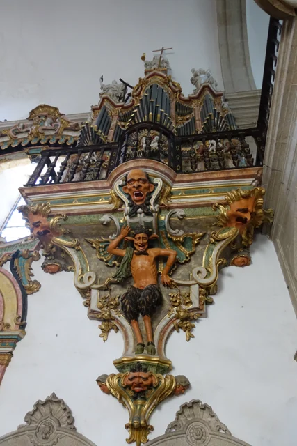
Two organs, one of them mute

Organ with tubes and golden cut, on carved figures and decorative faces.
View of the organ and the decoration that sustains it, photographed in 2016. The image does not determine which of the two organs is the mute.
Photography: Joseolgon · CC BY-SA 4.0
About this photograph

Date given at source: . Source consulted in 2026-11-07. EXIF orientation, proportional resizing and WebP conversion; no retouching or clipping of the file.

Request removal or correct the photo credit

See more 2 photos and details
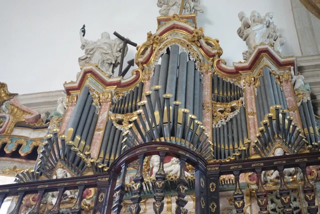
Organ tubes at different heights, surrounded by golden cut and light sculptures.
Details of the tubes, cut and sculptures of the organ in 2016.
Photography: Joseolgon · CC BY-SA 4.0
About this photograph

Date given at source: . Source consulted in 2026-11-07. EXIF orientation, proportional resizing and WebP conversion; no retouching or clipping of the file.

Request removal or correct the photo credit

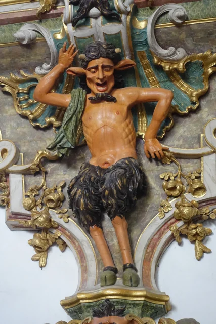
A figure carved with horns, pointed ears and fur-covered legs between golden elements.
Details of a figure carved under the organ in 2016.
Photography: Joseolgon · CC BY-SA 4.0
About this photograph

Date given at source: . Source consulted in 2026-11-07. EXIF orientation, proportional resizing and WebP conversion; no retouching or clipping of the file.

Request removal or correct the photo credit

An invitation to look beyond the facade.

Includes an activity to try →Explore: The pulpits had more than one step. →
Read here and view sources

The municipal description identifies two lateral organs, being a mute. The visual symmetry of the church does not correspond, therefore, to two sound instruments. Next to the entrance appear frowns; later, the wood creates another surprise effect.

The two pulpits are painted brown to imitate marble and partially golden. The fountain places the execution in 1777–1780 and the painting and browning in 1786–1789. Shape, material and finishing count different stages of the same work. This patrimonial description does not confirm the current functioning of the organ.

The choir adds another reading of the wood: the Municipality describes a brown chair, of 1767–1770, organized in two levels and in the shape of U. São 45 seats, with the place of the abbot to the center. The disposition helps imagine a community gathered, instead of looking at each chair separately.

At the top, the circular zimbarium is accompanied by interior and exterior balconies. The description identifies the twelve apostles and, on the top, St. Michael. From furniture to silhouette, they change the scale and the observation point. The photographs of this reading show details of the organ; they do not document all these elements.

Words in this story: see explanations →See Fact sheet: Mosteiro de São Miguel de Refojos
Source and context

Municipality — history and art of Mosteiro de São Miguel de Refojos

Accessed: . Editorial summary; the date of consultation is not the date of the facts.
Documentary memory · 1758

Olela had days of meeting

The story was also made between banks and buyers.

Read here and view sources

In the relationship of Santa Senhorinha of 1758, Olela appears as a place of fairs in December, February and March. The parish priest refers payments for settlement and rights. It is a window on local exchanges of that time, not the calendar of markets today. The text specifies the days: 14 and 15 December, 24 and 25 February and 27 March. The dates belong to the account of 1758.

Getting to know the parish
Source and context

Municipality — Parish memories of Santa Senhorinha, 1758
Accessed:

Municipality — Memória de Santa Senhorinha, 23/05/1758, replies 15, 19 and 20; transcription of José Viriato Capela (2003)
Accessed:

Editorial summary; the date of consultation is not the date of the facts.
Pedraça · Parish memories of 1758

A Pedraça call to Coimbra

In 1758, the parish priest's choice pointed out to the council.

Includes an activity to try →Explore: Read a document, ask questions →
Read here and view sources

The parish memory describes the matrix dedicated to Santa Marinha and states that the rector was presented by the rector of the College of São Jerónimo de Coimbra. This historical link shows how a small parish was part of relations that surpassed the lands of Basto.

The same transcript places Pedraça at the end of Cabeceiras de Basto and in the district of Guimarães. It records 96 fires and 322 souls of communion, in addition to a congruity of 50 thousand réis for the rector. They are categories of the document: fires are not people, and souls of communion do not automatically equal the total inhabitants.

The numbers and connection to Coimbra show two plans of parish life: the community described and the organization that framed his parish priest. The municipal version identifies the transcription of José Viriato Chapel, published in 2003, from the Memórias of 1758.

The municipal page also distinguishes the account from the references that accompany it: it refers to the memory 296 of the volume 42 and lists an obligation to the Santa Bárbara hermitage factory, of 1624, and another linked to the Blessed Sacrament, of 1722. They are archive clues. The existence of these references does not mean that the full text of the two documents is reproduced on the page, nor transforms 1624 on a date of construction of the chapel.

Words in this story: see explanations →Getting to know the parish See Fact sheet: Igreja paroquial de Pedraça See Fact sheet: Santa Bárbara de Pedraça — capela e miradouro
Source and context

Municipality — Parish Memories of Pedraça (1758), transcript of José Viriato Chapel (2003)
Accessed:

Municipality — Parish Memories of Pedraça, 1758; transcription of José Viriato Chapel (2003)
Accessed:

Editorial summary; the date of consultation is not the date of the facts.
Outeiro · landscape and historical interpretation

The relief gives a clue to the name

A gently wavy landscape on the western shore of the municipality.

Includes an activity to try →Explore: Read Outeiro by three paths →
Read here and view sources

On the western bank of the municipality, next to Fafe, Outeiro is described by the Municipality as a softly wavy relief plateau. The presentation relates the name to this landscape and points to the proximity of the headquarters and the fixing of houses along the road.

The municipal page proposes a medieval interpretation of the names of the places and refers to the scarcity of archaeological data. This formulation needs to be dealt with with the inventory of the PDM published in 2026, which identifies three archaeological sites in Outeiro. The name of the parish still does not itself provide a date of foundation.

Words in this story: see explanations →Getting to know the parish
Source and context

Municipality — Outeiro, relief and hydrographic network

Diary of the Republic — Notice No 16185/2026/2, PDM Cabeceiras de Basto, archaeological inventory AQL34–AQL36, p. 92 (29/06/2026)

Accessed: . Editorial summary; the date of consultation is not the date of the facts.

Arco de Baúlhe · railway memories

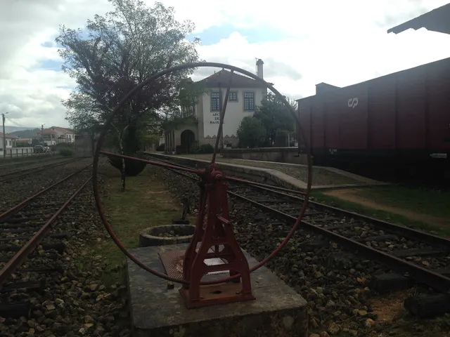
Before the train, the tiles arrived

Revolving plate and tracks from the old Arco de Baúlhe station, with buildings and railway equipment at the bottom.
Facade of the station of Arco de Baúlhe, with coating and tile panels visible to the background. View of JP Ribeiro; it is not a detail of the panels of 1940.© JP Ribeiroⓘ

The station also reads on the walls.

Includes an activity to try →Explore: A station, different spaces →
Read here and view sources

The station panels were executed in 1940 by A. Lopes, at the Sant’Anna Ceramic Factory in Lisbon, according to the publication of the Basto Land Museum. They are prior to the opening of the station in 1949.

The station was a set of spaces with different functions. The publication identifies the driver's house, the staff building, the loading and unloading dock and the dispatch warehouse. The two stalls started to host permanent exhibitions of railway equipment; the warehouse is described as temporary exhibition space.

Reading the building can begin with these differences: where were they working, where were goods passing and where were they stored? The tiles are part of this built landscape. The description documents the museological organization presented in the publication, without confirming the exhibition or access of each space today.

Getting to know the parish See Fact sheet: Núcleo Ferroviário de Arco de Baúlhe
Source and context

Municipality — Land Museum of Basto: a journey through the history of the region, pp. 28–29

Municipality — Núcleo Ferroviário de Arco de Baúlhe

Accessed: . Editorial summary; the date of consultation is not the date of the facts.

Arco de Baúlhe · railway memories

A gas engine on the rails

The collection counts different ways to get a train moving.

Explore: Who and what was riding the tracks? →
Read here and view sources

The ME5 motor vehicle carried a petrol engine to the rails. The publication on the museum located its construction in the Santa Apolónia workshops in 1948. In the same collection, it describes a steam locomotive manufactured in Germany in 1908.

The dates are forty years and allow comparing two technologies. They are dates of construction of vehicles, not of arrival at the station. The collection gathers pieces from various origins; being in the museum does not show, by itself, where each one circulated.

The Basto Land Museum identifies the engine as Chevrolet and describes the passenger space: 11 first-class seats, 16 third-class and other 16 standing, as well as sanitary facilities. The 27 seating positions shall not be confused with all available positions.

The National Railway Museum explains that a single motor vehicle sought to reduce the costs of operation in lines of low traffic, bringing together functions that required a composition. The project, directed by the engineer Vasco Viana, took advantage of characteristics of road transport. The same record says that the use of gasoline proved costly and led to temporary or extraordinary uses.

The inventory adds a link to the local history: this ME5 will have circulated in the Line of Tâmega. The formulation is prudent and so remains. It is a specific documentary track, different from deducing the circulation just because the vehicle is in the collection today.

Getting to know the parish See Fact sheet: Núcleo Ferroviário de Arco de Baúlhe
Source and context

Municipality — Land Museum of Basto: a journey through the history of the region, pp. 28–29

Basto Land Museum — Heritage with history: Self-propelled ME5, 22/02/2018

National Railway Museum MEf5, FMNF/ARC/ Inventory000203

Accessed: . Editorial summary; the date of consultation is not the date of the facts.

Heritage of Abadim

A tower to look slowly

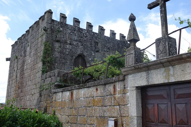
Tower of Abadim, with yellow crowning and stone constructions around.
Tower of Abadim · yellow crowning and surrounding constructions.© Joseolgonⓘ

History is also read in windows and corners.

Explore: Read the marks of power and time →
Read here and view sources

The Tower of Abadim has battlements at the top and gargoyles with animal shapes in the corners. António P. Dinis highlights the settery, the broken arch doors and, inside, conversationals next to the windows. It proposes a construction of the sixteenth century, perhaps from the foral period, without setting an exact date.

The memory of 1758 places the tower in the middle of the Village of the Tower and states that it did not suffer ruin in the earthquake of 1755. The same document describes Abadim with ordinary judge and Chamber, in an organization proper to the former Couto. Reading architecture and administration together helps to understand the importance of the building; the interior description does not confirm current access.

The text of António P. Dinis distinguishes the probable place of the medieval manor from the quintentist construction described today. It is not necessarily the same building preserved without change. The designation Casa do Tronco accompanies the hypothesis that here the justice and the chain of trust functioned.

In the memory of 1758, the election of the ordinary judge and of the House was presided over by the donate. The document also refers to the intervention of the Guimarães magistrate in correction or new scope. Thus, the existence of own organs should not be confused with an administration without relations with other authorities.

Words in this story: see explanations →See Fact sheet: Torre de Abadim / Casa do Tronco
Source and context

Basto Land Museum / António P. Dinis — Tower of Abadim, 17/01/2018

Municipality — Parish memories of Abadim, José Antunes, 22/05/1758

Accessed: . Editorial summary; the date of consultation is not the date of the facts.

History of Ponte de Cavez

Five arches, more than a while

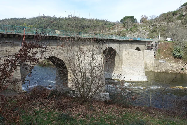
Ponte de Cavez on the river Tâmega, with stone arches, board and wooded banks.
Partial view of the Ponte de Cavez over the Tâmega.© Joseolgonⓘ

An old bridge didn't stop in history.

Includes an activity to try →Explore: A crossing, several seasons →
Read here and view sources

Three broken central arches and two perfect back, next to the banks: the Ponte de Cavez brings together different shapes and times. The Museum located the medieval construction in the second half of the 13th century, at the service of the road between Braga and Vila Pouca de Aguiar.

The source attributes the round arches to the works of Philip II's reign and mentions a landmark of 1599. In the 19th century, the road between Fafe and Vila Pouca de Aguiar brought the enlargement of the board. Watching the bridge is looking for changes to an ancient crossing.

According to the Museum, the stone bridge replaced a previous wooden, then degraded. The construction is attributed to Frei Lourenço Mendes, Dominican who gathered alms for the work; the museological text mentions testimonial legacies as support of this connection. The crossing thus involves materials, paths and ways to finance a collective work.

Words in this story: see explanations →See Fact sheet: Ponte de Cavez
Source and context

Land Museum of Basto — Ponte de Cavez, 27/02/2022

Municipality of Cabeceiras de Basto — Parish memories of 1758: Cavez

Municipality — conclusion of rehabilitation of Ponte de Cavez, 30/04/2019

Accessed: . Editorial summary; the date of consultation is not the date of the facts.

Holy Lady · memory of 1758

Not all bridges were stone

The wood also united the banks.

Read here and view sources

The memory of 1758 lists three wooden bridges in the parish: Vagalhafos, in Quinta de Vila de Lobos; Santa Senhorinha, near the church; and Olela. Names approach the crossings of the farms, the place of worship and the inhabited places.

The same report mentions singing bridges in São Clemente and São Martinho do Arco de Baúlhe. Wood and stone appear, thus, in a single description of the river. The enumeration does not provide construction dates nor proves the survival of structures.

Words in this story: see explanations →
Source and context

Municipality — Memória de Santa Senhorinha, 23/05/1758; transcript of José Viriato Chapel (2003)

Accessed: . Editorial summary; the date of consultation is not the date of the facts.

Heritage of Outeiro · account published in 2012

A Medieval Image Found On Earth

Wood can keep centuries of memory.

Includes an activity to try →Explore: Three moments, different dates →
Read here and view sources

A municipal report of 2012 highlights a sculpture of Santa Maria belonging to the church of Outeiro, dating from the 13th or 14th century. The Virgin appears crowned, seated on a throne, with the Child on his knees. The account says that the play was found buried in the place known as Mata da Santa and taken by parishioners to church. The news doesn't date the discovery. This story allows to know the path of the image, without confirming where it is currently exposed.

Words in this story: see explanations →See Fact sheet: Igreja de Santa Maria Maior de Outeiro
Source and context

Municipality — Parish of Outeiro exposes acquis No Núcleo de Arte Sacra, 09/10/2012

Accessed: . Editorial summary; the date of consultation is not the date of the facts.

Alvite · written account from 1758

The earthquake has reached the account of Alvite

A local memory of a larger event.

Includes an activity to try →
Read here and view sources

In reply to the 1758 survey, the vicar of Alvite recalled the earthquake of 1755. He said there had been no ruins, except for the arms of two crosses of the chapel of the House of the Tower, which would have been twisted north. He added that they were already straight.

The report separates the event from the state observed when it was written. It is a local testimony, not a measurement of the intensity of the earthquake nor a confirmation of visible marks today.

Source and context

Municipality — Memory of Alvite, 23/05/1758; transcription of José Viriato Chapel (2003)

Accessed: . Editorial summary; the date of consultation is not the date of the facts.

Regional rail link · Celorico bridge Basto

To get to the Arc, the line needed to cross another valley

The history of the Cabeceiras train also passes through the neighboring municipality.

Includes an activity to try →Explore: A bridge ready, an uncompleted connection →
Read here and view sources

Before reaching Cabeceiras, the line had to cross the valley of the river of Veade. The bridge of Matamá is in the Union of the Freguesies of Veade, Gagos and Molares, in Celorico of Basto. According to the Museum, its six granite arches form a structure about 190 meters long and 52 meters high.

The report distinguishes two moments: the opening of the bridge in 5 June 1936, and the entry into railway use in 15 January 1949, with the opening of the Celorico section of Basto–Arco de Baúlhe. Having the bridge built did not immediately mean having trains arriving at the Arc. This regional history helps to realize the time needed to complete the connection.

The report of the Museum attributes the responsibility of the work to engineers Jorge Vieira Bastian and Manuel Gonçalves Costa. The dimension of the structure helps to realize the challenge of taking the railway through the valley; the chronology allows to separate this work from the entry into service of the complete connection.

Source and context

Basto Land Museum / Pedro T. Gonçalves — Matamá Railway Bridge, 28/07/2026

Municipality — Land Museum of Basto: a journey through the history of the region, pp. 28–29

Accessed: . Editorial summary; the date of consultation is not the date of the facts.

Refojos · history of assistance since 1877

Care is also part of the story

Mercy was born of a local initiative in the 19th century.

Read here and view sources

The review of Santa Casa places its constitution in September 1877, with the purpose of supporting poor people who needed health care. The first statutes were approved in January 1879. In 1896 opened a hospital, replaced in the years 1950 by the Hospital Professor Julio Henriques. The institution highlights the contribution of the population to this new unit. These dates help follow a history of assistance and cooperation; they do not describe the health services available today.

Source and context

Santa Casa da Misericórdia of Cabeceiras de Basto — historical review of the institution

Accessed: . Editorial summary; the date of consultation is not the date of the facts.

Tâmega · service memory line in 1984

The goods had a marked day

The Tâmega Line also carried goods.

Includes an activity to try →
Read here and view sources

Numa publicação de agosto de 2025, o Museu recorda o serviço de mercadorias que circulava à quarta-feira na Linha do Tâmega, em 1984. Era associado à locomotiva E 165, fabricada pela Henschel & Sohn em 1908. A imagem postal usada pelo Museu foi feita em Celorico de Basto: documenta a linha, não a estação do Arco.

The support is a postcard from the Portuguese Association of Friends of the Iron Paths, dated 1984. There are three times to distinguish: the construction of the machine, the service remembered in the postcard and the publication of the Museum. The document does not describe the load of each trip.

Source and context

Basto Land Museum — The “Modern Market”, 2025-08-27

Accessed: . Editorial summary; the date of consultation is not the date of the facts.

Pedraça · housing

Pedraça is also counted by houses

Beyond the church, there is a housing landscape.

Includes an activity to try →Explore: Houses, persons and work in Pedraça →
Read here and view sources

The history of Pedraça is also read in the houses. The municipal presentation highlights Casa do Paço, Casa de Parada and the houses of the Baron of Basto and Paço de Vila. For Parada, it uses the expression Brazilian taste; for Casa do Paço, it draws attention to the name of the place. They are different clues: one points to architecture, another to the toponymy.

These houses are part of a parish that the Municipality describes as fertile and abundant in water, linked to agriculture and the cultivation of flax. Approaching the housing of the work landscape helps to look at the heritage beyond religious buildings.

The municipal description does not provide construction dates for this set nor identifies those responsible for each work. Nor does the reference to Brazilian taste enough to reconstruct the biography of a owner. The houses are here starting points to know the parish; their inclusion does not presuppose public access.

Words in this story: see explanations →
Source and context

Municipality — parish presentation of Pedraça

Accessed: . Editorial summary; the date of consultation is not the date of the facts.

Refojos and Coimbra · historical route of the chalice

From Refojos to Coimbra, a history in motion

Objects also go through changes in institutions.

Includes an activity to try →
Read here and view sources

According to the study of 1995, the chalice remained in Refojos until the mid-16th century and went to the College of São Bento de Coimbra, in the context of the work of Frei Diogo de Murça. After the extinction of religious orders in 1834, he passed to the Treasure of the Sé de Coimbra. The record of the Machado de Castro Museum documents its current connection to the collection. This journey adds a material history to the relationship between Refojos and Coimbra.

See Fact sheet: Mosteiro de São Miguel de Refojos
Source and context

Portvgalia, new series, volume XVI (1995) — study of medieval goldsmithry, analysis of the cup of Refojos

Museu Nacional de Machado de Castro — Cálice, ficha da coleção no Google Arts & Culture

Accessed: . Editorial summary; the date of consultation is not the date of the facts.

Cavez · settlement and devotion in 1758

Eight places and six chapels

In Cavez, an ancient list draws relations between villages, residents and monasteries.

Includes an activity to try →
Read here and view sources

In 25 of May 1758, the vicar Manuel Pacheco da Cunha numbered eight places: Cavez, Vila Franca, Ponte, Arosa, Rabiçais, Moimenta, Revorça and Parada. He located the church in the middle of the parish and described six chapels. Names help to recognize a hammock; they are not a current list of administrative places.

São Gregório, in Vila Franca, São Mamede, in Arosa, and Santa Maria Magdalena, in Moimenta, were attributed to the abbot of Pombeiro, with its maintenance linked to the Benedictine congregation of Tibães. São Bartolomeu, on the Bridge, had as patron João Correia, of Guimarães. In São Caetano, in Raviceis at the passage of the chapels, and Santa Luzia, in Revorça, the charge was for the residents. The transcription itself uses the variants Rabiçais and Raviceais.

The report also describes five altars in the matrix and a brotherhood of the Souls. The parish appears as a space of worship and collective organization, with distinct responsibilities. The pilgrimage of São Bartolomeu is mentioned for 23 and 24 of August; they are dates of historical testimony, without functioning as current agenda.

The parish links went beyond the chapels. The vicar wrote that Cavez did not have their own mail and resorted to Raposeira, which was located to a league. He also indicated the absence of fair in the parish. They are clues to think where news arrived and where services were concentrated at that time; they do not describe the current offer nor allow automatically to convert the league into a road distance.

Getting to know the parish See Fact sheet: Capela de São Bartolomeu de Cavez See Fact sheet: Igreja de São João de Cavez e cruzeiro
Source and context

Municipality of Cabeceiras de Basto — Parish memories of 1758: Cavez

Accessed: . Editorial summary; the date of consultation is not the date of the facts.

Outeiro · archaeological inventory published in 2026

Three places, several layers of past

Outeiro is also known through archaeology.

Includes an activity to try →
Read here and view sources

The PDM inventory of 2026 brings together three archaeological references in Outeiro: the Medieval Sepulturas da Mata Santa, the Shelter of the Serra da Penouta and Outeiro of Pena.

The Santa Forest appears as a medieval necropolis. Penouta shelter is attributed to Neolithic/Calcolithic; Outeiro of Pena appears as shelter/atalaya, with the indication Prehistory/Media. These are categories and periods of inventory, not three exact dates of construction.

These entries open a longer story than the explanation of the name of the parish. They do not demonstrate continuous occupation between the indicated periods, nor do they establish a link between the graves and the sculpture of Santa Maria. The documentary reference also does not confirm conditions of visit.

Words in this story: see explanations →
Source and context

Diary of the Republic — Notice No 16185/2026/2, PDM Cabeceiras de Basto, archaeological inventory AQL34–AQL36, p. 92 (29/06/2026)

Accessed: . Editorial summary; the date of consultation is not the date of the facts.

YOUR LOCAL GUIDE

What would you like to discover?

Take a closer look.