Discover Cabeceiras de BastoFree independent guide
ViveCabeceirasYOUR GUIDE TO CABECEIRAS
ENEnglish
SearchSaved

Stories of Cabeceiras

Choose a story to start with. You can change the subject or fine tune the search.

57 stories · All themes · Search: linha

Time travel

Documents, details and traditions: there is more to discover than a date on a stone.

Choose a story · 17
Arco de Baúlhe e Vila Nune · line memory and path transformation

The line has gained new steps
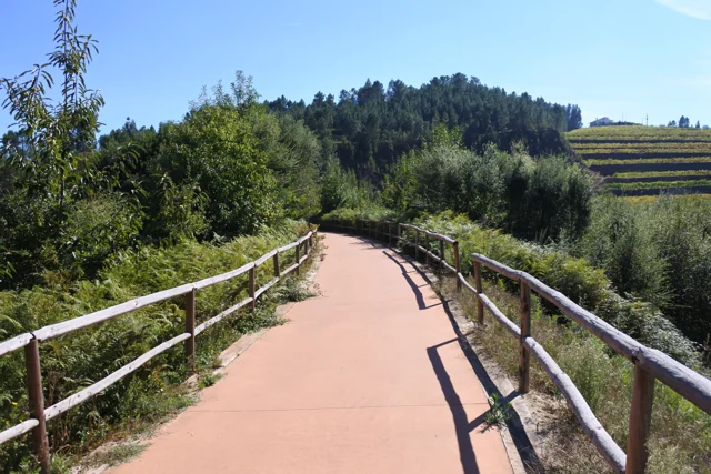
Tâmega Ecopist in Arco de Baúlhe e Vila Nune, with reddish pavement and wooden guards, photographed in October 2016.
The former railway channel converted to Ecopista in Arco de Baúlhe e Vila Nune. Photo by FF Mira, October 6, 2016; does not document the inauguration of 2013 or the current conditions of the entire route.© FF Miraⓘ

The old train path began to receive hikers and bicycles.

Explore: Three Ways to Guard the Railroad →
Read here and view sources

The Tâmega Line channel retained a connecting function after trains. In 20 of April 2013 was inaugurated the section of the Ecopista in the municipality, between the Railway Center of Arco de Baúlhe and Dead Woman, in Vila Nune. The municipal record indicates 5,4 kilometers in this section, within the most extensive link to Amarante.

The relief of the route holds the railway origin: the municipal description relates the old channel with a maximum inclination of 3%. It is a published feature of the layout, not a current check of each entry or obstacle. To prepare an exit, see the practical form and the on-site indications.

The old station and the villager of Vila Nune tell different parts of this story. The municipality identifies the camper among the heritage of Vila Nune; in the Arc, the station passed the museological core. A path can change its use without losing the references that help to recognize its past.

See Fact sheet: Ecopista do Tâmega — troço de Cabeceiras See Fact sheet: Antigo apeadeiro de Vila Nune
Source and context

Municipality — Ecopist of Tâmega: reuse of channel and inauguration of 2013

Municipality — Arco de Baúlhe e Vila Nune: former tenant

Basto Land Museum — Railway Station Arco de Baúlhe classified as Municipal Interest Set, 02/04/2025

Accessed: . Editorial summary; the date of consultation is not the date of the facts.
History of transport · Arco de Baúlhe

One line took forty years to arrive

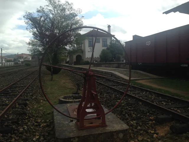
Revolving plate and tracks from the old Arco de Baúlhe station, with buildings and railway equipment at the bottom.
Former station Arco de Baúlhe · railway heritage© JP Ribeiroⓘ

The Arc was the end point of a trip through Tâmega.

Includes an activity to try →
Read here and view sources

The journey began at Livração, where the Line of Tâmega connected to the Douro Line, and ended at Arco de Baúlhe. According to the Municipality, the construction of this narrow track line extended from 1908 to 1949, along about 52 kilometers. The arrival at the Arc was the result of a link built in stages.

The station had functions beyond the shipment of passengers: the old warehouse of dispatches, today used for temporary exhibitions, also recalls the circulation of goods. Visiting the railway core allows you to look for these different lives of the same space: transporting people, receiving cargoes and preserving stories.

Getting to know the parish See Fact sheet: Núcleo Ferroviário de Arco de Baúlhe
Source and context

Municipality — Núcleo Ferroviário de Arco de Baúlhe

Accessed: . Editorial summary; the date of consultation is not the date of the facts.

Regional rail link · Celorico bridge Basto

To get to the Arc, the line needed to cross another valley

The history of the Cabeceiras train also passes through the neighboring municipality.

Includes an activity to try →Explore: A bridge ready, an uncompleted connection →
Read here and view sources

Before reaching Cabeceiras, the line had to cross the valley of the river of Veade. The bridge of Matamá is in the Union of the Freguesies of Veade, Gagos and Molares, in Celorico of Basto. According to the Museum, its six granite arches form a structure about 190 meters long and 52 meters high.

The report distinguishes two moments: the opening of the bridge in 5 June 1936, and the entry into railway use in 15 January 1949, with the opening of the Celorico section of Basto–Arco de Baúlhe. Having the bridge built did not immediately mean having trains arriving at the Arc. This regional history helps to realize the time needed to complete the connection.

The report of the Museum attributes the responsibility of the work to engineers Jorge Vieira Bastian and Manuel Gonçalves Costa. The dimension of the structure helps to realize the challenge of taking the railway through the valley; the chronology allows to separate this work from the entry into service of the complete connection.

Source and context

Basto Land Museum / Pedro T. Gonçalves — Matamá Railway Bridge, 28/07/2026

Municipality — Land Museum of Basto: a journey through the history of the region, pp. 28–29

Accessed: . Editorial summary; the date of consultation is not the date of the facts.

Tâmega · service memory line in 1984

The goods had a marked day

The Tâmega Line also carried goods.

Includes an activity to try →
Read here and view sources

Numa publicação de agosto de 2025, o Museu recorda o serviço de mercadorias que circulava à quarta-feira na Linha do Tâmega, em 1984. Era associado à locomotiva E 165, fabricada pela Henschel & Sohn em 1908. A imagem postal usada pelo Museu foi feita em Celorico de Basto: documenta a linha, não a estação do Arco.

The support is a postcard from the Portuguese Association of Friends of the Iron Paths, dated 1984. There are three times to distinguish: the construction of the machine, the service remembered in the postcard and the publication of the Museum. The document does not describe the load of each trip.

Source and context

Basto Land Museum — The “Modern Market”, 2025-08-27

Accessed: . Editorial summary; the date of consultation is not the date of the facts.

Arco de Baúlhe · railway memories

The train stopped, the memory stayed

Revolving plate and tracks from the old Arco de Baúlhe station, with buildings and railway equipment at the bottom.
Arco de Baúlhe station and railway equipment. Context photography, not of the closing day.© JP Ribeiroⓘ

The station gained another function after closing the line.

Explore: From the last journey to preserved memory →
Read here and view sources

According to the retrospective of the Museum, the Arc station ceased to operate in January 1990, with the closure of the section between Amarante and Arco de Baúlhe. In 8 January 2000, a protocol between REFER and the Municipality opened the way for the provision of facilities and the museological dynamics. The opening of the Museum, in 23 May 2004, belongs to this new life of space.

The compromise brought responsibilities: the Municipality was responsible for preserving, maintaining and managing the section, in collaboration with the National Railway Museum Foundation. The news of the Museum of April 2025 also reports the municipal decision of February 14 of that year to classify the whole. The change of use involved, therefore, agreements and continued work, in addition to the opening of doors to the public.

See Fact sheet: Núcleo Ferroviário de Arco de Baúlhe
Source and context

Basto Land Museum — Railway Station Arco de Baúlhe classified as Municipal Interest Set, 02/04/2025

Accessed: . Editorial summary; the date of consultation is not the date of the facts.

Documented history · 1514

Two outcasts, seven days

October 1514 left two marks on the territory.

Includes an activity to try →Explore: Abadim: documents and marks in place →
Read here and view sources

Manuel I granted the foral of Cabeceiras in 5 October 1514 and that of Vadym, today Abadim, in 12 October. Seven days separate the documents: the administrative history of the territory goes through more than one place.

But what was the point of reviewing the outsiders? The Tombo Tower exhibition explains the general context: there were complaints about outdated charges, coins and weights and old texts difficult to interpret. Manueline reform sought to review these documents. Local dates of 1514 belong to this broader movement; it does not mean that the settlements began to exist that year.

The work also required registration and preservation. The same exhibition describes the preparation in triplicate: one copy for the chamber, one for the landlord of the rights and another for the Tower of the Tombo. This general explanation helps to understand why an administrative document could have several copies. It does not identify here the whereabouts of each copy of the two local forals.

In 5 October 2024, Casa do Tempo received a tertulia over the 510 years of the foral, with José Viriato Chapel and Porfirio Correia. The municipal news recalls the two documents and their importance for the administrative organization. The celebration is a gateway to history; it does not replace the reading of the forals themselves.

Words in this story: see explanations →
Source and context

Municipality — celebration of fora, published in 07/10/2024

DGLAB / Torre do Tombo and Casa de Bragança Foundation — O Foral Novo: records that tell stories, pp. 2 and 4 PDF

Accessed: . Editorial summary; the date of consultation is not the date of the facts.

Alvite · Couto organisation in 1758

One land, two skills

In 1758, not all issues were decided by the same power.

Includes an activity to try →Explore: The territory seen by different rules →
Read here and view sources

The account of St. Pedro of Alvite distinguishes the civil subjects, linked to the Abbot and the convent of Refojos, from the criminals, attributed to the municipality judge of Cabeceiras. The Couto thus had an organization that is not limited to a line on the map. It's a historical description, no correspondence with the current administration. There is an important territorial distinction: the answer places Petimão in the term of Celorico of Basto. The skills of the Couto are described for other places, avoiding reading the entire parish as a single jurisdiction.

Getting to know the parish
Source and context

Basto Land Museum — Parish Memories of 1758: Alvite

Municipality — Alvite Parish Memories, 1758; transcription of José Viriato Chapel (2003)

Accessed: . Editorial summary; the date of consultation is not the date of the facts.

Outeiro · landscape and historical interpretation

The relief gives a clue to the name

A gently wavy landscape on the western shore of the municipality.

Includes an activity to try →Explore: Read Outeiro by three paths →
Read here and view sources

On the western bank of the municipality, next to Fafe, Outeiro is described by the Municipality as a softly wavy relief plateau. The presentation relates the name to this landscape and points to the proximity of the headquarters and the fixing of houses along the road.

The municipal page proposes a medieval interpretation of the names of the places and refers to the scarcity of archaeological data. This formulation needs to be dealt with with the inventory of the PDM published in 2026, which identifies three archaeological sites in Outeiro. The name of the parish still does not itself provide a date of foundation.

Words in this story: see explanations →Getting to know the parish
Source and context

Municipality — Outeiro, relief and hydrographic network

Diary of the Republic — Notice No 16185/2026/2, PDM Cabeceiras de Basto, archaeological inventory AQL34–AQL36, p. 92 (29/06/2026)

Accessed: . Editorial summary; the date of consultation is not the date of the facts.

Bucos · testimony of 1758

A chapel shortened the distance

In Casares, getting to church was a practical matter.

Includes an activity to try →
Read here and view sources

In the memory of 22 May 1758, the chapel of Santa Maria, in Casares, served to administer the sacraments to the residents, far from the parish church. The distance helped explain the distribution of places of worship.

The vicar António Alves Teixeira also mentions Santa Ana, in Carrazedo, administered by Manuel Gomes Martins. They are references of the document, without confirmation of access or current status.

The parish church was located in the place of Bucos, which the vicar presented as the most populous of the parish. In addition, he named Vila Boa, Carrazedo and Casares. This set of places helps to understand why a single church did not respond in the same way to the needs of all residents.

The document also distinguishes who administered each chapel: in Casares, the commander; in Carrazedo, Father Manuel Gomes Martins. Place, invocation and administration are three different clues. The function of administering sacraments because of the distance is explained to Casares; it should not be automatically attributed to all the chapels mentioned.

Getting to know the parish
Source and context

Municipality — Parish memories of Bucos (1758)

Accessed: . Editorial summary; the date of consultation is not the date of the facts.

São Nicolau · 1758 account

When the chapel shortened the path

The distance from the church also shaped the villages.

Includes an activity to try →Explore: Three Ways to Approach Places →
Read here and view sources

The memory of 1758 explains the function of three chapels: Saint Bartholomew, in Celeiró do Monte; Our Lady of Lapa, in Lapela; and Saint Anne, in Busteliberne. They served to administer sacraments to the residents who lived far from the matrix. A small building responded to a daily difficulty.

The dean Domingos Camel de Sousa describes high hills between the places and refers three settlements away half league from the church, in rough terrain. The distance was not only a line on the map: relief was part of the difficulty. The church was to spring, in a place with six neighbors, counting the house of the rector himself.

The three chapels were kept at the expense of the commendator, according to the report. But they were not the only ones: the text lists eleven chapels beyond the matrix, with different administrations and functions. In the Outeiro of Santo António, for example, it marks pilgrimages of neighboring parishes in the feasts of Santo António and Santa Luzia. The set reveals both the cult close to the residents and meetings that attracted people from outside.

Words in this story: see explanations →Getting to know the parish See Fact sheet: Busteliberne See Fact sheet: Igreja de São Nicolau de Cabeceiras
Source and context

Basto Land Museum — St Nicholas Parish Memories (1758)

Accessed: . Editorial summary; the date of consultation is not the date of the facts.

Arco de Baúlhe · railway memories

A gas engine on the rails

The collection counts different ways to get a train moving.

Explore: Who and what was riding the tracks? →
Read here and view sources

The ME5 motor vehicle carried a petrol engine to the rails. The publication on the museum located its construction in the Santa Apolónia workshops in 1948. In the same collection, it describes a steam locomotive manufactured in Germany in 1908.

The dates are forty years and allow comparing two technologies. They are dates of construction of vehicles, not of arrival at the station. The collection gathers pieces from various origins; being in the museum does not show, by itself, where each one circulated.

The Basto Land Museum identifies the engine as Chevrolet and describes the passenger space: 11 first-class seats, 16 third-class and other 16 standing, as well as sanitary facilities. The 27 seating positions shall not be confused with all available positions.

The National Railway Museum explains that a single motor vehicle sought to reduce the costs of operation in lines of low traffic, bringing together functions that required a composition. The project, directed by the engineer Vasco Viana, took advantage of characteristics of road transport. The same record says that the use of gasoline proved costly and led to temporary or extraordinary uses.

The inventory adds a link to the local history: this ME5 will have circulated in the Line of Tâmega. The formulation is prudent and so remains. It is a specific documentary track, different from deducing the circulation just because the vehicle is in the collection today.

Getting to know the parish See Fact sheet: Núcleo Ferroviário de Arco de Baúlhe
Source and context

Municipality — Land Museum of Basto: a journey through the history of the region, pp. 28–29

Basto Land Museum — Heritage with history: Self-propelled ME5, 22/02/2018

National Railway Museum MEf5, FMNF/ARC/ Inventory000203

Accessed: . Editorial summary; the date of consultation is not the date of the facts.

Arco de Baúlhe · railway memories

A place in the third class

A carriage opens a window for the journeys of other times.

Read here and view sources

The Visit Cabeceiras portal highlights a third-class British carriage of 1876 at the Railway Nucleus. The class number and date help to locate the object: it is a 19th-century piece, long before the line arrived at Arco de Baúlhe. The presence in the collection does not mean that it was built for this station.

The municipal publication identifies this piece as Cefv 79 and presents it as the oldest carriage in the collection described there. In the same stall, it refers to a passenger carriage built in Belgium in 1908.

The inventory mark helps distinguish the object; the class refers to its function in passenger transport. The origin of manufacture, service provided and arrival at the museum are separate questions: these sources do not reconstitute all carriage trips.

Getting to know the parish See Fact sheet: Núcleo Ferroviário de Arco de Baúlhe
Source and context

Visit Cabeceiras — Railway core Arco de Baúlhe
Accessed:

Municipality — Land Museum of Basto: a journey through the history of the region, pp. 28–29
Accessed:

Editorial summary; the date of consultation is not the date of the facts.

Alvite · written account from 1758

The earthquake has reached the account of Alvite

A local memory of a larger event.

Includes an activity to try →
Read here and view sources

In reply to the 1758 survey, the vicar of Alvite recalled the earthquake of 1755. He said there had been no ruins, except for the arms of two crosses of the chapel of the House of the Tower, which would have been twisted north. He added that they were already straight.

The report separates the event from the state observed when it was written. It is a local testimony, not a measurement of the intensity of the earthquake nor a confirmation of visible marks today.

Source and context

Municipality — Memory of Alvite, 23/05/1758; transcription of José Viriato Chapel (2003)

Accessed: . Editorial summary; the date of consultation is not the date of the facts.

Pereiras, Refojos · football in the 20th century

When football won the field

The Pereiras are also part of sports memory.

Includes an activity to try →Explore: The Pereiras had several lives →
Read here and view sources

In Pereiras, the memory of the municipality also passes through football. The Basto Land Museum identifies the field inaugurated in 1925 as the first of Cabeceiras de Basto. It served from home to different sports communities, linking the place to the practice of the game and the meetings of those who accompanied it.

In 1982, the construction of the National Road 311 led to the move of the countryside to another location. A sports equipment can thus help count the transformation of a settlement: space changes, but memory preserves the connection to the previous place.

The Museum article, published in July 2024, places the field in a place that had trade, school and fairs. The bibliography includes The Journal of Cabeceiras, of 20 September 1925, and Ecos of Cabeceiras, of 15 August of that year. They are references indicated by the Museum, without reproducing here the contents of these newspapers.

Source and context

Basto Land Museum — The place of the Pereiras of Refojos de Basto, 28/07/2024

Accessed: . Editorial summary; the date of consultation is not the date of the facts.

Line of Tâmega · object presented by the Museum in June 2024

The last light told a story

A red light signaled that the train was going full.

Includes an activity to try →Explore: Two lights, different tasks →
Read here and view sources

The last vehicle of the train carried important information. The Museum features a red-light taillight, used at night in the last carriage or wagon to indicate that the composition was complete. Its function was to signal, not to illuminate the path ahead of the locomotive.

The registration N.1 AND POST. OF THE BOOK connects the object to the station of Livração, in the line of the Valley of Tâmega. Reading the piece implies joining three clues: the color of the light, the position on the train and the inscription associating it to a place.

This small object shows that the railway history is also made of discrete signs and tasks. The presentation of the Museum, published in June 2024, describes the use and station to which the lighthouse was affected; it does not indicate a date of manufacture for the piece.

Words in this story: see explanations →
Source and context

Land Museum of Basto — Taillight “N.1 AND POSTO. FREEDOM”, 2024-06-28

Accessed: . Editorial summary; the date of consultation is not the date of the facts.

Alvite · heritage and landscape deployment

A chapel leaning against the stone

In Santa Catarina, the construction finds the penedia.

Includes an activity to try →Explore: One chapel, three scales →
Read here and view sources

The municipal presentation highlights a particularity of the chapel of Santa Catarina de Alvite: it is encrusted in a penedia. The encounter between rock and construction gives a clue to look at the heritage beyond the facade.

The source identifies this relationship with the place, but does not provide here a construction date or a visiting time. The chapel form gathers the available documentary information.

The memory of 1758 already named Santa Catarina in the hill with this name, among six chapels of the parish. The two sources answer different questions: the old document places it in a network of places of worship; the municipal presentation draws attention to the relationship between construction and rock. This presence in the report does not date the external form that the photograph shows.

See Fact sheet: Capela de Santa Catarina de Alvite
Source and context

Municipality — landscape of Alvite e Passos

Basto Land Museum — Parish Memories of 1758: Alvite

Accessed: . Editorial summary; the date of consultation is not the date of the facts.

Gondiães e Vilar de Cunhas · banknotes published on 1758

Two old portraits, two ways to count

A short note can also open a window to the story.

Includes an activity to try →
Read here and view sources

The municipal transcription of 1758 presents Gondiães with 55 fireworks and 269 souls of communion, together with the matrix dedicated to Saint Martin. Vilar mentions 41 neighbors and 141 sacramental souls, with the church dedicated to St. Lawrence. Both places are located at the end of Cabeceiras de Basto, in the district of Guimarães.

It is important to keep the words of the source: fires or neighbors and souls are not the same category. These numbers should not be added as if they all counted people, nor presented sacrament souls as a modern census of the total population. The text of Gondiães gives the information to Lima; the reference should accompany the reading of these numbers.

Source and context

Municipality — Parish Memoirs of Gondiães (1758), transcript published from José Viriato Chapel (2003)

Municipality — Parish Memoirs of Vilar de Cunhas (1758), reference to José Viriato Chapel (2003)

Accessed: . Editorial summary; the date of consultation is not the date of the facts.

Between rivers and mountains

Water and relief form the municipality. Choose a name and follow the landscape.

Choose a story · 13
Rio Douro · project announced in April 2025

On the common lands, woodland meets waterways

A Rio Douro project reveals different roles within one landscape.

Includes an activity to try →Explore: The slope meets the river →
Read here and view sources

In April 2025, Antarr announced the start of work agreed with the Comunidade Local dos Baldios de Riodouro, covering around 500 hectares of Cabreira partly affected by the 2016 and 2024 fires. The plan combined forestry production, conservation and the restoration of about 40 hectares of riverside vegetation. It shows that managing a hillside also involves areas beside water. These figures are the promoter’s announced targets, not confirmation of completed work or achieved results.

The April announcement places the start of work in February 2025. For the first phase, it announces around 220 hectares of production species and approximately 80 hectares of varied broadleaved trees and conifers. These areas have different purposes; they are not a record of completed planting.

Relief also enters the project: the promoter describes plateaux, steep slopes and large variations in altitude. Reading the landscape therefore brings together landform, production areas and sensitive zones beside water. There is no complete breakdown of the 500 hectares here from which to draw every plot.

Source and context

Antar — announcement of the start of the Riodouro project, 04/04/2025; objectives announced by the promoter

Accessed: . Editorial summary; the date of consultation is not the date of the facts.

Geographical framework

Cabreira, Barroso and Lameira

Three names to help you read the landscape.

Includes an activity to try →Explore: From the mountain to the river, choose the path →
Read here and view sources

The municipal description uses three mountain ranges to frame Cabeceiras: Cabreira and Barroso to the north, Lameira to the west. These are orientation points, not mountains entirely contained within the municipality.

The neighbours complete the picture: Montalegre and Boticas to the north, Vieira do Minho to the north-west and Fafe to the west. Reading the landscape also means recognising continuity beyond administrative boundaries. Start with names and directions, then look more closely at the villages and changes in altitude.

Source and context

Municipality — geographical framework

Accessed: . Editorial summary; the date of consultation is not the date of the facts.

Saint Nicholas · rivers in 1758

Bridges put to the winter test

Crossing the river was part of everyday life.

Includes an activity to try →Explore: Cross, sail or water? →
Read here and view sources

The São Nicolau account of 1758 describes three wooden bridges. It says that winter waters sometimes covered the two higher ones and even swept some bridges away. This is historical testimony about floods and routes, not a way to assess the safety of today’s crossings. The document names Sendim, Cerdeiró and Ponte do Gado: these crossings helped connect the church with settlements in the parish.

The description goes beyond the force of floods. It mentions a watercourse with many falls, difficult to ford and, in some stretches, even difficult to follow along its banks. The bridges answered that challenge of the terrain.

The Sendim bridge lay on the route from the church to that settlement; the Cerdeiró bridge served the direction of Breia. Ponte do Gado was lower than the other two and gave its name to the point where the branches from Bucos entered. These details connect paths with waterways without fixing every structure’s position on a modern map.

Getting to know the parish
Source and context

Basto Land Museum — St Nicholas Parish Memories (1758)

Accessed: . Editorial summary; the date of consultation is not the date of the facts.

Rio Douro · Parish memories of 1758

Two rivers tell a parish’s story

The 1758 account describes Rio Douro between east and west.

Includes an activity to try →Explore: Water linking villages and works →
Read here and view sources

In the 1758 account, the Vilela river flowed to the east and the Rio Douro river to the west, both from north to south. The parish priest described their origins in small springs and their waters increasing with contributions from the mountains. He said the Vilela entered the Tâmega below Cavez bridge and the other joined the river coming from São Nicolau. These are the names and geographical relationships in that document, not a current navigation map.

Bridges bring that geography closer to village life. The document mentions a wooden crossing between Magusteiro and Teixugueiras and a stone one between Teixugueiras and the church. It also refers to wooden links from Eiró and Rio Douro to the church, and a stone one between Vilela and the church. Water and paths therefore appear in the same portrait of the parish.

The priest describes rivers with rocks, weirs and waterfalls, unsuitable for navigation but useful to mills and fields. They were more than lines separating places: they belonged to work and travel. These references come from the testimony signed on 22 May 1758; they do not confirm the survival of structures or present access to the banks.

There is a clue to imagining the relief: the author describes three parallel mountain ridges extending from Salto, with rivers in the lower spaces. The ridges’ names varied between places. Rather than seeking a single name for each mountain line, the document invites us to connect position, villages and the direction of water.

Words in this story: see explanations →Getting to know the parish
Source and context

Municipality of Cabeceiras de Basto — Parish memories of 1758: Rio Douro

Accessed: . Editorial summary; the date of consultation is not the date of the facts.

Outeiro · hydrographic network

A small river shapes the map too

In Outeiro, the Trutas joins the Peio.

Includes an activity to try →Explore: A tributary and water works →
Read here and view sources

The municipal description identifies the Trutas as a small tributary of the Peio flowing through Outeiro. Knowing this link helps us see waterways as a network beyond the better-known rivers. The name Trutas, meaning trout, does not in itself confirm those fish are present today.

Outeiro’s position also helps locate this network: the parish occupies the municipality’s western edge, beside Fafe. The municipal description presents a gently rolling plateau, with agriculture among the economic activities mentioned. Reading the territory means bringing these scales together: the municipal boundary, the relief and the small watercourse heading towards the Peio.

Try showing these relationships in a simple drawing. You do not need to reproduce an exact map: an arrow can indicate the rivers’ connection and another mark can place Outeiro on the western side of Cabeceiras.

Words in this story: see explanations →Getting to know the parish
Source and context

Municipality — Outeiro, relief and hydrographic network

Accessed: . Editorial summary; the date of consultation is not the date of the facts.

Bucos · testimony of 1758

Two rivers lost their names

Water connected mountains, mills and fields.

Includes an activity to try →Explore: Follows water of Bucos →
Read here and view sources

In 1758, the vicar of Bucos described two watercourses that eventually lost their names on entering the river of São Nicolau. One was Porto Souto, coming from the Serra da Maçã; the other, called the River Moinhos, had origins described in Carrazedo and Figueiró do Monte.

The account brings water and work together: cultivated banks, mills for cereals and water used in farming. It also mentions small wooden footbridges. Reading these elements together helps us imagine connections between fields, crossings and milling. The names and uses belong to the 1758 document; they do not automatically identify watercourses or structures found on the ground today.

Porto Souto is described as flowing all year despite its low volume, with small falls along its north-to-south course. The other watercourse had a calmer current. The vicar records trout and fish called escalos in both: his attention moves from flowing water to fish and then to cultivated banks. A river need not be large for its importance to parish life to become clear.

The text also compares two scales of crossing: the Casares bridge on a busy road and pedestrian crossings made from a single wooden beam. The author stresses the need to improve the former. The river therefore appears linked both to farmers’ daily work and to travel beyond the parish.

Getting to know the parish
Source and context

Municipality — Parish memories of Bucos (1758)

Accessed: . Editorial summary; the date of consultation is not the date of the facts.

Landscape and garden · Painzela

Water shapes the garden at Piellas

Among the clipped shrubs, there are other paths to follow.

Includes an activity to try →Explore: The garden within the landscape →
Read here and view sources

At Piellas, water helps connect garden, woodland and fields. The description published by Revista Jardins places an L-shaped pool beside the wall, near a passage to the Casa do Boal woodland. Another pool, surrounded by bamboo and box, opens towards a cultivated field bordered by woodland. The water continues to the Painzela stream.

The article also describes paths shaded by vine pergolas and a farmyard associated with former maize and wine production. The estate therefore brings together places for leisure and work: its garden of clipped shrubs belongs to a wider landscape.

Try imagining the estate in layers: terraces, paths, vegetation and the water system. The description connects these elements but does not provide a complete map of the water circuit. Piellas is private property; consult the place profile for visiting conditions.

See Fact sheet: Casa de Pielas, jardins e anexos
Source and context

Jardins Magazine — Gardens of Portugal: Route of the Tâmega, section Casa de Piellas

Accessed: . Editorial summary; the date of consultation is not the date of the facts.

Relief of the municipality

From mountains to valley, the map changes height

Look at Cabeceiras from north to south.

Includes an activity to try →
Read here and view sources

The 2025 environmental report places most areas above 800 metres in the north. To the south, beside the Tâmega, land lies below 200 metres. This contrast helps us read the relief: the landscape opens from mountain towards valley. The Archaeological Survey describes the hills as a south-facing amphitheatre. It also links the narrow strips of the northern parishes with their sharing of mountain and valley: the lived territory does not end at a single altitude.

These figures describe parts of the municipality, not two uniform levels. The report characterises the relief as becoming gentler southwards towards the Tâmega. On a walk, a village, a hillside and a valley floor can help us ask questions of the map: where does each place lie, and how does it relate to water?

A difference in altitude is not a walking distance either. Saying two points lie at different heights tells us neither how far we walk between them nor the gradient of the whole route. This story helps interpret the territory; route conditions require their own information.

The dominant direction has exceptions too. The Archaeological Survey highlights waters descending the slopes of Senhora da Orada and entering the Peio. A south-facing landscape therefore does not mean every stream follows a parallel line to the Tâmega. Valleys and tributaries are part of that organisation.

Source and context

Municipality — Environmental Report of the PDM review, February 2025, p. 50

Municipal Archaeological Charter — Orography and geology

Accessed: . Editorial summary; the date of consultation is not the date of the facts.

Geology and agriculture · lowlands of the municipality

The river helps explain the fields too

Near the Tâmega, the ground holds another story.

Includes an activity to try →Explore: Same territory, three looks →
Read here and view sources

On low ground near the Tâmega, the Archaeological Survey describes accumulations of sand and clay associated with some of the lowland fields offering the greatest farming potential. The contrast is clear: large granite outcrops dominate the slopes; beside the river, deposited materials help explain another way of farming. The same introduction shows hills descending southwards, with waterways seeking the Tâmega and its tributaries. It is not a soil map of each field, but a key to reading the whole landscape.

Words in this story: see explanations →
Source and context

Municipality — Archaeological Charter: Orography and geology

Accessed: . Editorial summary; the date of consultation is not the date of the facts.

Faia · municipal description of the settlement

A road helps explain Faia

Not every settlement grows around a single centre.

Includes an activity to try →
Read here and view sources

In the south of the municipality, beside the boundary with Celorico de Basto, the municipality describes Faia through its proximity to Arco de Baúlhe and the distribution of settlement along the EN 206. The road helps explain a pattern of occupation that is not confined to a single centre.

The introduction connects access, farming, wine-growing and crafts such as cooperage and handmade footwear. To discover the parish, connect houses and paths with these memories of work. This reading of the municipal source does not replace current mapping or identify open workshops.

Source and context

Municipality — presentation of Faia: settlement and traditional activities

Accessed: . Editorial summary; the date of consultation is not the date of the facts.

Council · Water resources in the 2025 report

There is water beneath the ground too

The map of water resources does not end at the surface.

Includes an activity to try →Explore: Look at the water in different ways →
Read here and view sources

For groundwater, the municipal environmental report of February 2025 identifies units of the Undifferentiated Ancient Massif associated with the Douro, Ave and Cávado basins. In the same document, the municipality’s surface-water bodies belong to the Douro River Basin District. These are different readings of the territory: rivers at the surface and water underground. The reference does not identify wells to visit or assess the water in any spring.

How does water fit inside rock? The USGS explanation points to pores and fractures: spaces between particles and cracks that can contain water. Porosity describes the available spaces; permeability describes how easily water flows through the material. Spaces alone are not enough: the connections between them matter too. This is a general explanation, not a measurement of Cabeceiras’s rocks.

Source and context

Municipality — Environmental Report of the PDM review, February 2025, pp. 56–58: water network and resources

USGS — Water Science School: groundwater, porosity and permeability

Accessed: . Editorial summary; the date of consultation is not the date of the facts.

Abadim · water and grinding in memory 1758

Two streams kept six mills working

Even a little water could keep a landscape moving.

Includes an activity to try →Explore: From water to food →
Read here and view sources

In 1758, the abbot of Abadim describes two streams descending southwards, meeting near Ponte de Pé and continuing to the Tâmega. There was little water, but it flowed all year. The account mentions trout and fish called bogas without identifying species by scientific names.

On the western stream, he notes Ranha’s dressed-stone bridge. Of the various mills on the two waterways, six belonged to the parish. This count identifies neither today’s buildings nor whether they were the same mills as the group now called Moinhos de Rei.

The abbot describes swift currents and neighbouring communities’ free use of the water. Little water and movement were therefore not incompatible in his account. The story gains another dimension beside the fields: the same document distinguishes cereals grown in different settlements. The streams belonged to a landscape of cultivation and processing, although the account does not say which mill received each village’s grain.

Words in this story: see explanations →
Source and context

Municipality — Parish memories of Abadim, José Antunes, 22/05/1758

Accessed: . Editorial summary; the date of consultation is not the date of the facts.

Council · environmental relations described in the report of 2025

A river begins before its banks

What happens on the land can travel with the water.

Includes an activity to try →Explore: Follow water to the surface and underground →
Read here and view sources

Water flowing over the surface can carry soil and nutrients into waterways. The municipal environmental report of February 2025 connects this process with erosion and incorrect use of fertilisers rich in phosphorus and nitrogen. Excessive nutrient enrichment can encourage eutrophication, changing the aquatic environment.

The document also distinguishes groundwater: it notes that excessive use of nitrogen fertilisers can contribute to nitrate accumulation and increased salinity. What happens on the land therefore matters both to the water we see flowing and to water underground.

These are potential pressures described in an environmental assessment. They do not identify a discharge in a particular field or let us assess a river by appearance. To understand the system, connect land, surface runoff and aquifers while keeping general possibilities separate from measurements at a site.

Source and context

Municipality — Environmental Report of the PDM review, February 2025, p. 59: land uses and water resources

Accessed: . Editorial summary; the date of consultation is not the date of the facts.

Life you do not always see

Knowing animals begins by perceiving the territory and respecting the distance.

Choose a story · 12
Gondiães · record from 1994 and general species biology

An ocellated lizard was recorded in Gondiães

A line in a table preserves an observation from 1994.

Includes an activity to try →
Read here and view sources

A scientific article published in 1996 records Lacerta lepida in Gondiães, Cabeceiras de Basto, on 16 April 1994. The University of Évora lists that former name among the synonyms of Timon lepidus, the ocellated lizard. It describes the species as the Iberian Peninsula’s largest lizard, with dark-edged blue spots on its flanks. The record documents a past occurrence; it does not confirm a current presence or identify an observation point.

Source and context

J. Teixeira et al. — Nuevos datos sobre la distribución de la herpetofauna en Portugal, Boletín AHE 7 (1996), p. 11; PDF sheet 13
Accessed:

University of Évora — Virtual Museum of Biodiversity, Timon lepidus; MVBIO / Darío Estradiz López
Accessed:

Editorial summary; the date of consultation is not the date of the facts.

Mammals · behaviour and local reference

Wild boar come out as the light fades

A long snout and a very varied diet.

Includes an activity to try →
Read here and view sources

The wild boar, Sus scrofa, is omnivorous and is mainly active at dusk and at night. During the day it may shelter in dense scrub. Plataforma Lobo-ibérico documents a wild boar killed by wolves in Serra da Cabreira, in Cabeceiras, without giving the record’s date. Its long snout and thick coat distinguish it from the domestic pig. Despite being omnivorous, the source describes a mainly plant-based diet. This flexibility helps explain its adaptation to different landscapes.

The platform also uses the Portuguese name porco-bravo and describes marked differences between the sexes. It discusses the species’ expansion in Portugal, including areas near urban centres. That national context cannot tell us how many wild boar live in Cabeceiras.

The Cabreira record and the description of habits answer different questions: one documents an encounter between predator and prey; the other helps explain the species’ life. This single reference cannot establish how often predation occurs or the size of local populations.

Source and context

Lobo-Iberico platform in Portugal — wolf prey; registration of Cabreira without date indicated

Accessed: . Editorial summary; the date of consultation is not the date of the facts.

Species biology · photograph recorded in the municipality

A grasshopper makes it through winter

The name Egyptian grasshopper does not confine the species to one country.

Includes an activity to try →
Read here and view sources

The name Egyptian grasshopper does not confine Anacridium aegyptium to one country. The Gulbenkian profile describes its distribution across parts of Europe, North Africa and the Middle East, and its presence in mainland Portugal in orchards, gardens, scrub and open woodland.

At the Gulbenkian Garden in Lisbon, adults are described as surviving the winter and basking on trees and shrubs on bright days. This observation helps explain the species, but cannot automatically be transferred to Cabeceiras. The local photographic record was made in September: it shows an encounter on that date, not winter behaviour in the municipality.

The Lisbon garden’s description mentions observation sites including rosemary hedges, strawberry trees, olive trees and other evergreen trees. Vegetation enters the story as part of the habitat adults use. These references do not tell you where to look for the grasshopper in Cabeceiras; they help explain why a profile can bring together an insect, a season and plants. When comparing the September photograph with the winter account, always record date and place separately.

Source and context

Calouste Gulbenkian Foundation — Anacridium aegyptium

Accessed: . Editorial summary; the date of consultation is not the date of the facts.

Species biology · photograph recorded in the municipality

Wing patterns tell a story of plants

A closer look at wings leads to the small world of grasses and herbs.

Includes an activity to try →Explore: Wings, plants and observation →
Read here and view sources

A photograph of Cymbalophora pudica offers a close look at its wing pattern. The Naturdata profile gives a wingspan of 35 to 43 millimetres: the distance between the tips of the open wings, not body length. This measurement comes from the species profile; it was not calculated from the local photograph.

The same source associates the species with the plant genera Taraxacum and Plantago, gives a flight period from August to October, and describes a distribution across the Iberian Peninsula, the Balearic Islands and North Africa. These details place the individual in a wider context.

The municipality’s photographic record, made in October, shows a particular encounter. It does not demonstrate the individual’s relationship with those plants or measure abundance or flight season in Cabeceiras. The image and profile answer different questions: one documents an encounter; the other brings together general species characteristics.

Words in this story: see explanations →
Source and context

Naturdata — Cymbalophora pudica

Accessed: . Editorial summary; the date of consultation is not the date of the facts.

Serra da Cabreira · regional reference and species biology

A desman’s life in the current

Cold water has its own inhabitants too.

Explore: The river is also a pantry →
Read here and view sources

The Pyrenean desman, Galemys pyrenaicus, is associated with cold, clear, well-oxygenated water, often in fast-flowing mountain rivers. The University of Évora also mentions the use of slower water, such as canals and lakes: a preference is not exclusivity. Its natural range is limited to the Iberian Peninsula and the Pyrenees. Conservation involves vegetated banks, shelters and connected habitats; the profile identifies silting and isolation among the threats. The municipal description of Cabreira’s fauna mentions the species, but this story has no geolocated record in the municipality.

Its elongated snout, shaped like a small trunk, helps it search for invertebrate larvae underwater, according to the Generalitat of Catalonia’s description. The technical profile hosted by ICNF highlights riverbed invertebrates as its food base, including caddisflies, stoneflies, mayflies and true flies. Small animals that may seem like details of the river are part of a mammal’s diet.

The ICNF profile adds a qualification for Portugal: it considers still-water habitats, such as reservoirs and small high-altitude lakes, unfavourable. The general reference to slower water should not become an invitation to search for the species in any lake. Suitable habitat also involves food, bank shelters and connections with other river sections.

Words in this story: see explanations →
Source and context

University of Évora — Virtual Museum of Biodiversity, Galemys pyrenaicus

Vieira Tourism of Minho — fauna of Serra da Cabreira, regional reference

ICNF — Galemys pyrenaicus, ecology and nutrition (historical references)

Generalitat de Catalunya — Iberian Desmán, description of snout and feeding

Accessed: . Editorial summary; the date of consultation is not the date of the facts.

Serra da Cabreira · regional reference and species biology

Wildcats need a varied landscape

Woodland for shelter, open ground for hunting.

Read here and view sources

The wildcat, Felis silvestris, is associated with scrub and woodland, often near rocky areas and watercourses. It may search for food in undisturbed meadows. A thick tail with dark rings and a rounded tip is one of the features described by the University of Évora. Its resemblance to domestic cats calls for care in identification.

The municipal source mentions it for Cabreira without locating a population in a particular parish.

The University of Évora’s description adds retractable claws and mainly crepuscular and nocturnal activity: twilight is the transition between day and night. The source lists habitat fragmentation and hybridisation with domestic cats among the threats. Appearance alone does not resolve every identification question.

Source and context

University of Évora — Virtual Museum of Biodiversity, Felis silvestris; David Germano
Consultations: ,

Vieira Tourism of Minho — fauna of Serra da Cabreira, regional reference
Accessed:

Editorial summary; the date of consultation is not the date of the facts.

Serra da Cabreira · general species behaviour

A tail that distracts a predator

The gold-striped salamander has a surprising defence.

Includes an activity to try →
Read here and view sources

When threatened, this salamander can shed its tail and regenerate it later. The detached part keeps moving, distracting the predator while the animal seeks shelter. Parque Biológico de Gaia describes this mechanism for the species mentioned by Visit Cabeceiras for Cabreira. It is something to learn about without touching or provoking the animal.

Parque Biológico de Gaia highlights this ability as unique among the salamanders of the Iberian Peninsula. The mechanism has two stages: immediate distraction by the detached tail, and later regeneration. These do not happen at the same time.

Compare this story with growth: losing part of the tail in defence and undergoing metamorphosis are different processes. A single photograph does not show the complete sequence of either. Learning about behaviour helps us understand the animal without trying to recreate a threatening situation.

Source and context

Gaia Biological Park — Chioglossa lusitanica
Accessed:

Visit Cabeceiras — natural heritage of Serra da Cabreira
Accessed:

Editorial summary; the date of consultation is not the date of the facts.

Soil life · general ecology

Earthworms change the landscape too

A tunnel can send leaves on a journey.

Includes an activity to try →Explore: A leaf can follow several paths →
Read here and view sources

Many earthworms eat plant remains or carry them through the tunnels they dig. A fallen leaf can therefore continue its journey beneath the surface.

By transforming organic matter and changing where they live, these animals act as ecosystem engineers. This is a general role, not an identification of species present in the municipality.

They do not all feed in the same place. FAO’s overview distinguishes worms that use debris near the surface from those feeding in deeper layers. Tunnels vary too: mainly vertical or horizontal, long-lasting or temporary shelters against unfavourable conditions.

Material passes through the digestive tract and returns to the soil as casts that bring together particles, organic matter and microorganisms. The work is therefore more than digging a tunnel: it involves transport and transformation. The tunnels support aeration, drainage and root penetration. Activity on the scale of a small animal can change the space available for water, air and other living things.

These differences explain why we should not imagine all earthworms as copies of one species. The story describes general roles and ways of life; it cannot count populations or measure a plot’s fertility just from the presence of one animal.

Source and context

Calouste Gulbenkian Foundation / Wilder — Cristina Cruz, Teresa Dias and Silvana Munzi (FCUL), 26/03/2024

FAO — Earthworms: food, galleries and soil structure

Accessed: . Editorial summary; the date of consultation is not the date of the facts.

Cabeceiras de Basto · occurrence mentioned in an environmental study

A bat entered the area’s records too

An environmental reference adds nocturnal life to the portrait of Cabeceiras.

Explore: From registration to questions about the species →
Read here and view sources

The environmental report for the Ribeira de Pena–Vieira do Minho power line, archived by the Portuguese Environment Agency, mentions a greater horseshoe bat, Rhinolophus ferrumequinum, record in a roost associated with Cabeceiras de Basto. This is documentary evidence of the species’ occurrence, not a current population count. The information does not allow a parish to be assigned here or an observation location to be announced.

Source and context

Matos, Fonseca & Associados / REN — EIA da Linha Dupla Ribeira de Pena–Vieira do Minho 1/2, relatório síntese, p.169; arquivo APA

Accessed: . Editorial summary; the date of consultation is not the date of the facts.

Reptiles · general biology, without a confirmed local record in this profile

One snake can have different patterns

Snake with the body wavy to the surface of the water, between blue reflexes and small ripples.
Viperine water snake swimming in Extremadura, Spain, in 2022. Illustration of the species; not a record of Cabeceiras.
Photography: Charles J. Sharp · CC BY-SA 4.0
About this photograph

Date given at source: . Source consulted in 2026-11-07. EXIF orientation, proportional resize and WebP conversion; no retouching or new clipping of file obtained in Commons.

Request removal or correct the photo credit

The viperine snake’s back does not always have the same pattern.

Includes an activity to try →Explore: The same environment, different ways of life →
Read here and view sources

Natrix maura, the viperine snake, can have a zigzag stripe, but also a pattern of two pale lengthwise lines. The Spanish biodiversity inventory also describes variation in body tones. A single pattern does not represent every individual of the species.

The Parque Natural do Litoral Norte profile explains its association with rivers, ponds, streams and other aquatic environments, without excluding movement on land. This is general species context, not an observation in Cabeceiras. The story compares variation and habitat; it is not a key for identifying snakes encountered outdoors.

The Charcos com Vida project describes feeding mainly in water: invertebrates, amphibian larvae and adults, and small fish are on the menu. Water is therefore a feeding space as well as a means of movement. The snake can itself be prey for birds and mammals; being a predator does not remove it from the food web.

It is usually active by day but may remain active at dusk or at night in summer. Behaviour also changes when threatened: the profile mentions widening the head and other defensive signals that contribute to its resemblance to a viper and its common name. This explanation of the name does not allow the species or the safety of an encounter to be decided from head shape.

Words in this story: see explanations →
Source and context

Inventory Español del Patrimonio Natural y la Biodiversidad — Natrix maura, description of the species

Co-management of the Northern Coastal Natural Park — Reptiles and amphibians, record of the viperine water snake

Lived Chargings — Viperine Water Cobra, Feeding and Behaviour

Accessed: . Editorial summary; the date of consultation is not the date of the facts.

Birds · general biology in Portugal

An acrobat among the leaves

The blue tit even searches for food upside down.

Read here and view sources

A blue cap and wings, white cheeks and a dark line beside the eyes help identify Cyanistes caeruleus. Its yellowish breast adds to the contrast. But watch how it moves too: the University of Évora describes this small bird hopping along branches and hanging upside down as it feeds.

Among the leaves, it searches for insects and spiders. In autumn and winter, fruits and seeds may also form part of its diet. Its food is therefore not a fixed list for every season: what it finds in the landscape changes.

The blue tit is resident and occurs across mainland Portugal. The Gulbenkian profile describes a range of wooded habitats, from woods and riverside trees to orchards, hedges and gardens. A garden and a wooded riverbank offer different settings in which to learn about this bird. These sources explain the species in Portugal; they do not document an encounter in a parish of Cabeceiras.

Words in this story: see explanations →
Source and context

University of Évora — Biodiversity of Mitra: Cyanistes caeruleus

Calouste Gulbenkian Foundation / João E. Rabaça — Blue Chapim

Accessed: . Editorial summary; the date of consultation is not the date of the facts.

Arco de Baúlhe e Vila Nune · local record and general biology

A slug with a leopard pattern

Discreet animals deserve a place in the municipality’s portrait too.

Includes an activity to try →
Read here and view sources

Mauro’s photograph shows a slug with dark markings and extended tentacles on stone. The record, dated 17 September 2021, is identified as Limax maximus. Comparing the published point with CAOP2025 places it in Arco de Baúlhe e Vila Nune.

The Royal Horticultural Society includes this species in its comparison of large patterned slugs, noting its nocturnal behaviour. The local photograph records an encounter; it cannot predict when the animal will appear in the same place again. Its body pattern offers a good question to begin with: where do you see separate spots, and where do they seem to form lines?

Alongside the photograph of the Cavez snail, it offers two different ways to discover land molluscs: the spiral of a shell and the pattern of an elongated body.

Source and context

Royal Horticultural Society — slug research and comparison with Limax maximus

Accessed: . Editorial summary; the date of consultation is not the date of the facts.

Crafts and memories

Through hands, food and community: small stories of how people lived and what they pass on.

Choose a story · 8
Pedraça · memory of learning linen crafts

A bowl of seeds, a skill passed on

Learning from another person is heritage too.

Includes an activity to try →Explore: Follow the thread to another object →
Read here and view sources

A bowl of seeds can be the start of a craft. In the Terra Inesgotável catalogue, Teresa Soeiro recounts how Fátima Mota of Pedraça learned from weaver Amélia Alves de Moura. After joining a flax harvest, she received linseed from her. She took it to her father, a farmer, who sowed it; harvesting the seeds allowed a larger area to be planted the following year. In this way, she obtained raw material to spin and weave independently.

The story brings three contributions together: the weaver’s teaching, the father’s farming and Fátima Mota’s own practice. Cloth begins long before the loom, through the connection between cultivation and learning.

The same catalogue shows linen grown and woven by Fátima Mota used in experimental footwear. Tradition enters another conversation: how can an old material and skill be used in a new object? The reference documents that experiment; it is not a catalogue of products currently for sale.

Source and context

Museum of the Footwear — Inexhaustible Land, pp. 42–43 (PDF pp. 44–45)

Accessed: . Editorial summary; the date of consultation is not the date of the facts.

Vila Nune · communications in 1758

News had its own arrival day

Two postal points connected Vila Nune with Porto.

Includes an activity to try →
Read here and view sources

In the Parish Memories of 1758, Vila Nune’s vicar says residents used the postal services at Raposeira, in the couto of Refojos, and at Mondim. Mail arrived from Porto on Mondays and left on Thursdays. News had its own routes and days: communication also meant waiting.

The vicar placed each postal point about one league away. The detail connects service with distance: knowing when news arrived was not enough; residents also depended on a place outside the parish. The account does not say who carried letters between that point and each resident.

Comparing the documents reveals a difference: Santa Senhorinha also used Raposeira, but its abbot gives Tuesday as the arrival day. We retain both versions. These answers alone cannot tell us whether the difference comes from how the service was described, an error or another circumstance.

Getting to know the parish
Source and context

Municipality — Parish Memoirs of Vila Nune, 23/05/1758

Municipality — Memória de Santa Senhorinha, 23/05/1758, replies 15, 19 and 20; transcription of José Viriato Capela (2003)

Accessed: . Editorial summary; the date of consultation is not the date of the facts.

Crafts · Faia, Basto and Refojos

Wood holds the wine too

Casks, vats and barrels tell a craft’s story.

Includes an activity to try →
Read here and view sources

The municipality associates these crafts with Faia and also mentions cooperage in Basto and Refojos. The container is as much a part of wine culture as the vine. At the ethnographic parade of 24 September 2023, devoted to arts and crafts, Faia presented its coopers. The municipal report shows how this skill was also chosen to represent the parish at a shared celebration. That occasion does not confirm a workshop open to visitors today. The parish introduction adds handmade footwear to its craft traditions. The wood used for wine containers is therefore part of a wider memory of work, without identifying today’s craftspeople or workshops here.

Two craft terms help explain how a container is built. The Museu da Lourinhã identifies staves and hoops as central elements: wooden pieces form the body, while hoops surround them. The description highlights the shaping of the staves’ curvature and thickness. This is a general explanation of cooperage, used here to read the objects; it does not document the production sequence of a workshop in Faia.

When looking at a barrel, find the vertical joins between pieces and the hoops encircling them. Then compare it with a clog’s wooden sole: a material can be carved to support a foot or worked into several pieces to form a container. The finished object holds decisions about shape, fitting and use.

Words in this story: see explanations →Getting to know the parish
Source and context

Municipality — crafts and services of the parishes

Municipality — Arts and Crafts in the Ethnographic Court, news of 25/09/2023

Municipality — presentation of Faia: settlement and traditional activities

Lourinhã Museum — Tanoeiro, elements and work of the plasters; general technical context

Accessed: . Editorial summary; the date of consultation is not the date of the facts.

Museu das Terras de Basto collection · Arco de Baúlhe

This mug made coffee

Not every mug was only for drinking.

Includes an activity to try →Explore: Three objects, three heights →
Read here and view sources

Copper mug MTB 241 was used to make coffee. The inventory records a height of 12 centimetres and a diameter of 7.2.

The piece belongs to the Museu das Terras de Basto in Arco de Baúlhe. No manufacture date or recipe is given. Compare the dimensions in the diagram: similar heights can conceal very different widths.

Source and context

Basto Land Museum — Latoaria, Teresa Soeiro text and inventory of pieces

Accessed: . Editorial summary; the date of consultation is not the date of the facts.

Material memory · Basto (Santa Senhorinha)

A funnel for making alheiras

Kitchen tools had very particular jobs.

Includes an activity to try →
Read here and view sources

Funnel L 65, made from sheet zinc, was used to make alheiras. The inventory links it to Devesa, Basto, and records a height of 6.1 centimetres and a diameter of 12.

The same collection contains funnels intended for transferring wine. The word funnel covers objects with different functions; this record neither documents a recipe nor confirms a current display.

Source and context

Basto Land Museum — Latoaria, Teresa Soeiro text and inventory of pieces

Accessed: . Editorial summary; the date of consultation is not the date of the facts.

Museu das Terras de Basto collection

A “fingernail” for the grape harvest

An object’s name can hold a small surprise.

Includes an activity to try →
Read here and view sources

The Museu das Terras de Basto’s unha — “fingernail” — MTB 437 was used to cut bunches of grapes. Made from sheet zinc, it measures 4.5 centimetres high. The inventory documents the utensil without explaining how it was used or attributing it to a village of origin.

The recorded diameter is 2.7 centimetres: a small piece with a very specific task. Its name, function and dimensions provide different clues. Unha is the inventory’s name for it; cutting bunches is its documented use.

The record connects vineyard work with the craft of shaping metal. Moving on to the stories of grape varieties and wine containers changes the scale: from a small utensil to the plant, harvest and movement of the product.

Source and context

Basto Land Museum — Latoaria, Teresa Soeiro text and inventory of pieces

Accessed: . Editorial summary; the date of consultation is not the date of the facts.

Painzela · irrigation documented in 2008

Seven users shared the channel

In Terreiros, irrigation left a trace in the ground.

Includes an activity to try →Explore: The water had different jobs →
Read here and view sources

The inventory of 3 May 2008 describes the Levada da Rebouta in Terreiros, Painzela, as a channel in natural ground. It received water from a small tributary of the Painzela stream, starting at Granja, and belonged collectively to seven shared users. The record noted that it had fallen out of use in the 1990s. This trace helps explain past irrigation arrangements, without assuming that the channel remains usable or accessible.

Source and context

Municipality — inventory of levadas, Rebouta, fiche L39 (03/05/2008)

Accessed: . Editorial summary; the date of consultation is not the date of the facts.

Terras de Basto · from fibre to fabric

Spinning is not weaving

Between fibre and cloth lies a world of tools.

Includes an activity to try →
Read here and view sources

The specifications for Linho das Terras de Basto distinguish preparing thread from building a fabric. Spinning may use a distaff and spindle, but the document also mentions a spinning wheel. A reel winds thread into skeins, which can then be wound into balls using a swift. Weaving requires preparing the warp and the thread that will cross it. The shuttle, shaped like a small boat, carries the weft between the warp threads. This description covers the Terras de Basto region; it does not identify a particular workshop in Cabeceiras.

Words in this story: see explanations →
Source and context

AMBT / CETRAD–UTAD — Land Linen Specification of Basto, pp. 19–27

Accessed: . Editorial summary; the date of consultation is not the date of the facts.

The flavours of Cabeceiras

From the garden to the pot, from the oven to the table.

Choose a story · 2
Oral memory · March 2011

The bread kept the next batch alive

A small piece of dough linked one batch to the next.

Includes an activity to try →Explore: Three ways to look at the same dough →
Read here and view sources

In an account recorded in March 2011, Maria da Conceição remembered bread being baked every eight days. A piece of dough from the previous batch was kept in a bowl with a little salt, inside the wooden kneading trough. On the eve of the next baking day, warm water and flour were added. The account from Recovos, Pedraça, also describes an adaptation: when baking became less frequent, yeast bought from the bakery was used.

This change is part of a family history. Maria da Conceição was born in Cavez and had learned to make maize broa from her grandmother. When she was interviewed, at the age of 69, she also made mixed-grain broa. The account does not present an unchanging tradition: it shows learning, choices and an adapting routine.

The baking calendar extended to the community too. In the 2011 account, batches of bread were associated with annual celebrations, a longing for homemade bread, the feast of Santa Marinha and Christmas and maize-husking events organised by the Associação D. Nuno Álvares in Pedraça. Keeping dough for the following week made sense in a weekly routine; occasional baking created different needs. These are practices remembered in that account, not a current programme of festivities.

Words in this story: see explanations →
Source and context

Basto Land Museum — testimony of Maria da Conceição Gonçalves Mouta, collected by Maria de Fátima Carvalho in 2011

Accessed: . Editorial summary; the date of consultation is not the date of the facts.

Regional gastronomy · history of the organisation of breeders

Behind Maronesa are the people preserving the breed

A regional flavour also tells a story of cooperation.

Explore: What happens before you get to the table? →
Read here and view sources

Maronesa is among the meats named by the municipality in its presentation of Cabeceiras’s food. The LIFE Maronesa project says the breeders’ association was founded in 1988 on the initiative of fourteen breeders. Its duties include managing the herd book and the use of the Carne Maronesa name. This provides context for a regional product without assigning a particular farm, availability or certification to a restaurant in the municipality.

The founding date is 30 September 1988. The collective work includes tasks rarely visible on a menu: identifying animals, maintaining records, agricultural advice and organising livestock competitions. The project page also describes services connected with breeding and transporting animals for the producer group.

These duties help explain the difference between preserving a breed and promoting a dish. The first involves breeders, identified animals and continuity of breeding lines; the second is a culinary use. The two stories may meet at the table, but the work behind them begins long before the kitchen.

Source and context

LIFE Maronese — Maronese Creators Association, history and functions

Municipality — gastronomy

Accessed: . Editorial summary; the date of consultation is not the date of the facts.

Read the landscape through the plants

Trees, forests, vineyards and fields reveal different ways of occupying the territory.

Choose a story · 4
Painzela · gardens and skills

Plants shaped by human hands

Camellias and yews are part of the story of these gardens.

Includes an activity to try →Explore: The garden also holds knowledge →
Read here and view sources

Camellias and yews trimmed into geometric or animal shapes: this is the art of topiary. The Portuguese Historic Gardens Association links this tradition to the school of Manuel Joaquim Alves Soares, continued by his son Joaquim. Casa de Piellas, in Painzela, is part of this history. It is private property; check the visiting conditions in its place profile.

The Rota do Tâmega presentation links this school of gardening to support from the sisters Emília Ermelinda and Justina Praxedes Pinto Basto. In the mid-19th century, they are said to have supported Manuel Joaquim Alves Soares’s training in Porto and England. The story of these plant shapes therefore also involves the sharing of knowledge and its transmission between generations.

Looking at topiary means looking both at a plant and at human skill. Geometric shapes organise lines and volumes; animal shapes evoke living creatures. The association identifies examples of this tradition at several estates in Basto, not just Piellas.

Words in this story: see explanations →Getting to know the parish See Fact sheet: Casa de Pielas, jardins e anexos
Source and context

Portuguese Association of Historical Gardens — Route Tâmega

Portuguese Association of Historical Gardens — Casa de Piellas, Painzela

Accessed: . Editorial summary; the date of consultation is not the date of the facts.

Agricultural landscape

Olive trees, cork oaks and vines

From the hillsides to cultivated river plains.

Includes an activity to try →
Read here and view sources

The municipal description follows the landscape from the hillsides to the river plains: olive trees and cork oaks appear alongside vines trained up other trees. The source mentions poplars, plane trees and fruit trees, including apple, orange and pear trees. It also describes slopes shaped into terraces and small plains beside rivers adapted for farming. This is a way of observing the relationship between relief, water and cultivation, rather than an up-to-date inventory of every plot.

Source and context

Municipality — landscape and vegetation

Municipality — Tourist sites: agricultural landscape and vegetation

Accessed: . Editorial summary; the date of consultation is not the date of the facts.

Observation in Gondiães e Vilar de Cunhas · botanical context

When ferns fill the landscape

One fern may be a small detail; many together form a fern bed.

Includes an activity to try →Explore: From where to the surface where it grows →
Read here and view sources

Flora-On describes Pteridium aquilinum subsp. aquilinum as a coloniser of burnt areas and abandoned pastures, where it can become dominant. This helps explain how a fern patch forms, but does not prove the history of the photographed ground. The Gondiães e Vilar de Cunhas observation identifies Pteridium aquilinum at species level: the image confirms neither the subspecies nor an earlier fire. Compare the whole hillside with the outline of a single frond.

The University of Évora profile describes a long underground rhizome from which leaves emerge. The greenery at the surface is only part of the plant: a stem extends below ground. Rhizome is not another word for root.

The fronds have a long stalk and a blade with an oval to triangular outline, divided into segments. The upper surface is hairless and the underside hairy. The description gives a usual leaf size of thirty centimetres to one and a half metres, sometimes larger. These are species measurements, not measurements of the photographed plant.

This fern can occur in sun or shade, including in understorey and on acidic ground. A patch alone does not show whether a site experienced fire, agricultural abandonment or another change.

Words in this story: see explanations →
Source and context

Portuguese Society of Botany — Flora-On: Pteridium aquilinum subsp. aquilinum
Accessed:

University of Évora — Biodiversity of Mitra, Pteridium aquilinum
Accessed:

Editorial summary; the date of consultation is not the date of the facts.

Landscape ecology of the municipality

A landscape needs connections

The gaps between green spaces matter too.

Includes an activity to try →Explore: Choose a part of the landscape →
Read here and view sources

An isolated green space does not tell the whole story. The municipal report of 2025 explains that fragmentation reduces and separates habitats, interrupting ecological processes. The ecological network aims to connect natural, agricultural and forest spaces, including gardens, tree-lined avenues and watersides in town. This is a proposal for understanding and planning the territory, not confirmation that all those connections already function.

Words in this story: see explanations →
Source and context

Municipality — Environmental Report of the PDM review, February 2025, p. 55
Accessed:

Municipality — Environmental Report, February 2025, pp. 50, 55 and 139
Accessed:

Editorial summary; the date of consultation is not the date of the facts.

A world beneath the leaves

A first look at the fungi. Continue in the gallery to see the local records already documented.

Choose a story · 1
Micorrizas · general ecology

Not every root makes a partner

Some associations are more specific.

Includes an activity to try →Explore: From root to landscape →
Read here and view sources

Partnerships are not all alike: some fungi associate with different plants, while others depend on a particular plant species.

Observing vegetation therefore helps us ask questions about what happens below ground. It does not, however, confirm which association is present at a particular point.

The partnership may involve trees, shrubs or herbaceous plants. The plant supplies organic compounds, while the association between roots and mycelium extends the search for water and nutrients. The plant partner is part of the fungus’s ecology, not just scenery around the mushroom.

Consider two different questions: “Which plants grow in this woodland?” and “Which plant does this fungus associate with?” The first can guide observation; answering the second requires knowledge of the association. Even in woodland with several tree types, seeing a mushroom near a trunk does not automatically identify its underground partner.

Source and context

Silvestrian Resource Competence Centre — General Mycology

Accessed: . Editorial summary; the date of consultation is not the date of the facts.

YOUR LOCAL GUIDE

What would you like to discover?

Take a closer look.