Discover Cabeceiras de BastoFree independent guide
ViveCabeceirasYOUR GUIDE TO CABECEIRAS
ENEnglish
SearchSaved

Rivers and mountains

Choose a story to start with. You can change the subject or fine tune the search.

47 stories · Between rivers and mountains · Search: serras

Between rivers and mountains

Water and relief form the municipality. Choose a name and follow the landscape.

Choose a story · 47
Passos · relief and water

A mountain and a river to locate Passos
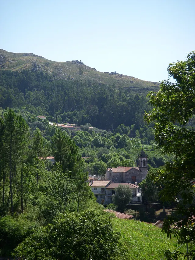
Wooded edge and house in the photograph identified by the author as Passos, Cabeceiras de Basto.
Landscape of Passos · slope and house; the river referred to in the text is not identified in the image.© Elisabeth LEITEⓘ

Two names help you read the municipality’s south-west.

Includes an activity to try →Explore: From landscape to work →
Read here and view sources

The Serra da Orada and River Petimão help locate Passos in south-western Cabeceiras. The municipal description highlights rugged terrain and farming, beside the municipalities of Celorico de Basto and Fafe.

The church of São Sebastião, wayside crosses and alminhas shrines add built landmarks to the landscape. River, mountain and heritage offer complementary clues to this place; they do not form a walking itinerary here or confirm access.

In its description of Passos, the municipality also mentions neighbouring former parishes: Outeiro, Refojos and Alvite. This local scale helps place the mountain and river within a shared territory. Administrative boundaries and landscape features are different ways of reading the same space.

Getting to know the parish See Fact sheet: Passos
Source and context

Municipality — landscape of Alvite e Passos

Accessed: . Editorial summary; the date of consultation is not the date of the facts.
Relief of the municipality

From mountains to valley, the map changes height

Look at Cabeceiras from north to south.

Includes an activity to try →
Read here and view sources

The 2025 environmental report places most areas above 800 metres in the north. To the south, beside the Tâmega, land lies below 200 metres. This contrast helps us read the relief: the landscape opens from mountain towards valley. The Archaeological Survey describes the hills as a south-facing amphitheatre. It also links the narrow strips of the northern parishes with their sharing of mountain and valley: the lived territory does not end at a single altitude.

These figures describe parts of the municipality, not two uniform levels. The report characterises the relief as becoming gentler southwards towards the Tâmega. On a walk, a village, a hillside and a valley floor can help us ask questions of the map: where does each place lie, and how does it relate to water?

A difference in altitude is not a walking distance either. Saying two points lie at different heights tells us neither how far we walk between them nor the gradient of the whole route. This story helps interpret the territory; route conditions require their own information.

The dominant direction has exceptions too. The Archaeological Survey highlights waters descending the slopes of Senhora da Orada and entering the Peio. A south-facing landscape therefore does not mean every stream follows a parallel line to the Tâmega. Valleys and tributaries are part of that organisation.

Source and context

Municipality — Environmental Report of the PDM review, February 2025, p. 50

Municipal Archaeological Charter — Orography and geology

Accessed: . Editorial summary; the date of consultation is not the date of the facts.

Geology and relief of the municipality

Read the mountains in their rocks

Before paths and houses, there was a landscape of rock.

Explore: From rock to field, follow the materials →
Read here and view sources

The municipality’s Archaeological Survey describes large granite outcrops bearing signs of erosion. The terrain descends from the southern edge of Cabreira towards the Tâmega basin in a succession of hilltops. Looking at these shapes helps connect mountain and valley: rock belongs to the territory’s history even when no one has worked it.

A rock can change without moving. This alteration is called weathering: it may involve physical fragmentation, chemical changes in minerals or the action of living things. The British Geological Survey gives simple examples: roots widening cracks, water freezing and expanding in fractures, or rainwater reacting with minerals. These are general mechanisms, not explanations that can be assigned to every block found in Cabreira.

When materials are removed and transported by water, wind or ice, erosion comes into play. The distinction helps us imagine two stages: the rock changes, then some of its material may travel. The stages need not proceed at the same rate, and a fragment need not reach the river directly.

This reading journey ends on the Tâmega’s lowland fields, where the municipal source describes deposits of sand and clay. Between exposed rock and a lowland field, different questions arise: what is the rock made of, how does it change, and where do transported materials end up?

Words in this story: see explanations →
Source and context

Municipality — Archaeological Charter: Orography and geology

British Geological Survey — Weathering: physical, chemical and biological alteration of rocks

Geological Society — Weathering: difference between change and erosion

Accessed: . Editorial summary; the date of consultation is not the date of the facts.

Landscape · Rio Douro

Moscoso looks out over the valley

Mountain houses, a stream and a name that stays with you.

Includes an activity to try →
Read here and view sources

Visit Cabeceiras presents Moscoso, in Rio Douro parish, as a preserved group of rustic houses in the Serra da Cabreira. The village faces the valley of the Cavez stream, where the description places Nariz do Mundo. It also mentions the nearby Poço das Relvas waterfall.

To read this landscape, try separating three elements: the houses, the valley and the hills beyond. Then bring them together again: the village gains context when it becomes more than a collection of buildings. The place profiles help you continue exploring; this description does not define a route between them.

See Fact sheet: Moscoso See Fact sheet: Nariz do Mundo
Source and context

Visit Cabeceiras — village Moscoso

Accessed: . Editorial summary; the date of consultation is not the date of the facts.

Bucos · testimony of 1758

Two rivers lost their names

Water connected mountains, mills and fields.

Includes an activity to try →Explore: Follows water of Bucos →
Read here and view sources

In 1758, the vicar of Bucos described two watercourses that eventually lost their names on entering the river of São Nicolau. One was Porto Souto, coming from the Serra da Maçã; the other, called the River Moinhos, had origins described in Carrazedo and Figueiró do Monte.

The account brings water and work together: cultivated banks, mills for cereals and water used in farming. It also mentions small wooden footbridges. Reading these elements together helps us imagine connections between fields, crossings and milling. The names and uses belong to the 1758 document; they do not automatically identify watercourses or structures found on the ground today.

Porto Souto is described as flowing all year despite its low volume, with small falls along its north-to-south course. The other watercourse had a calmer current. The vicar records trout and fish called escalos in both: his attention moves from flowing water to fish and then to cultivated banks. A river need not be large for its importance to parish life to become clear.

The text also compares two scales of crossing: the Casares bridge on a busy road and pedestrian crossings made from a single wooden beam. The author stresses the need to improve the former. The river therefore appears linked both to farmers’ daily work and to travel beyond the parish.

Getting to know the parish
Source and context

Municipality — Parish memories of Bucos (1758)

Accessed: . Editorial summary; the date of consultation is not the date of the facts.

Geographical framework

Cabreira, Barroso and Lameira

Three names to help you read the landscape.

Includes an activity to try →Explore: From the mountain to the river, choose the path →
Read here and view sources

The municipal description uses three mountain ranges to frame Cabeceiras: Cabreira and Barroso to the north, Lameira to the west. These are orientation points, not mountains entirely contained within the municipality.

The neighbours complete the picture: Montalegre and Boticas to the north, Vieira do Minho to the north-west and Fafe to the west. Reading the landscape also means recognising continuity beyond administrative boundaries. Start with names and directions, then look more closely at the villages and changes in altitude.

Source and context

Municipality — geographical framework

Accessed: . Editorial summary; the date of consultation is not the date of the facts.

Middle and upper Tâmega basin · landscape studied in 2016–2017

The river has a woodland too

Trees along the banks are part of the waterscape.

Includes an activity to try →Explore: The three zones of the river →
Read here and view sources

The 2016–2017 report describes riverside woodland in the middle and upper Tâmega basin with alders, ashes and willows, and birches along smaller waterways. It notes that these strips are often narrow, constrained by cultivated land. This is the regional description from that study, which covers Cabeceiras and other municipalities.

Bank, water and riverbed are connected but offer different conditions. The gold-striped salamander depends on damp environments and reproduces in water; young freshwater mussels live buried in the riverbed and need oxygen. The diagram explores these general relationships without representing a place where all these species have been observed together.

Source and context

Biosphere / Iberdrola, APA file — Monitoring of ichthyofauna 2016–2017, February 2018; pp. 5, 35 and 40, station record 22 on p. 175 PDF
Accessed:

Link to Nature Protection — Salamander-lusitan
Accessed:

ICNF — Margaritifera margaritifera, ecology, reproduction and threats, pp. 2–3
Accessed:

Editorial summary; the date of consultation is not the date of the facts.

Water memory · lifting of 2008

Water had its turn

From sunset to sunset, a community rule.

Includes an activity to try →
Read here and view sources

The survey of 4 March 2008 describes water from the Levada de Víbora shared in eleven 24-hour turns, called casais. Each turn began at sunset and ended at the following sunset. The starting order changed from year to year.

The names came from houses in Abadim: six casais were associated with Aldeia da Torre and five with Santo António. The granite channel carried water from the Busteliberne stream for irrigation and milling. The levada therefore had both a visible structure and an equally important organisation of time. These details belong to the 2008 inventory, not a current irrigation schedule.

Source and context

Municipality — inventory of taken, L1 and L18 forms (uplifts of 2008)

Accessed: . Editorial summary; the date of consultation is not the date of the facts.

Geographical framework

The Tâmega traces the boundary

A river that helps explain the south of the municipality.

Includes an activity to try →Explore: From limit to landscape →
Read here and view sources

The Tâmega follows much of Cabeceiras’s southern and south-eastern boundary. To the east, the municipality’s geographical introduction mentions the River Bessa. Water therefore helps locate the territory, alongside the mountains to the north and west.

The neighbouring municipalities to the south are Celorico de Basto and Mondim de Basto; Ribeira de Pena lies to the east. These references offer a starting point for reading the map before moving on to bridges, fields and the tributary network.

Complete the picture by looking to the other sides: Montalegre and Boticas to the north, Vieira do Minho to the north-west and Fafe to the west. Cabreira and Barroso frame the north; the Serra da Lameira frames the west. Administrative boundaries and the water network are two different ways to read the same territory: follow the tributaries next to see where the water goes.

Source and context

Municipality — geographical framework

Accessed: . Editorial summary; the date of consultation is not the date of the facts.

Landscape and agriculture

Peio, Ouro and the Cavez stream

Water also shapes work in the fields.

Read here and view sources

The farming landscape cannot be explained by the presence of water alone. The municipality’s tourism introduction describes two ways of adapting the land: terraces on hillsides and the use of small alluvial deposits associated with the Tâmega and waterways such as the Peio, Ouro and Cavez stream.

On the slopes, fields follow constructed steps; beside rivers, deposited ground is used. These are different ways of working with the terrain. Compare the shape of the fields and their relationship with water without assuming that every plot has the same origin or crop.

Words in this story: see explanations →
Source and context

Municipality — landscape and vegetation

Accessed: . Editorial summary; the date of consultation is not the date of the facts.

Saint Nicholas · hydraulic heritage inventoryed in 2008

The Peio made flour too

A river connected fields, weirs and mills.

Includes an activity to try →
Read here and view sources

The Levada do Casal record notes water drawn from the Peio near Ponte do Gado, in Gondarém. The inventory describes five mills along the channel. It is a record of water-powered heritage, not confirmation that the mills operate or are publicly accessible today.

The survey of 26 February 2008 identifies a channel in natural ground and two shared users: Casa do Casal and Quinta do Rapazinho, the latter with less irrigation time. It also describes the route near the Levada de Bouças and a boundary marker in Sendim placed to settle a disagreement over use. The channel carried water, but its use also depended on agreements between people.

Source and context

Municipality — inventory of taken, L1 and L18 forms (uplifts of 2008)

Accessed: . Editorial summary; the date of consultation is not the date of the facts.

Landscape · Abadim

Follow the water’s path

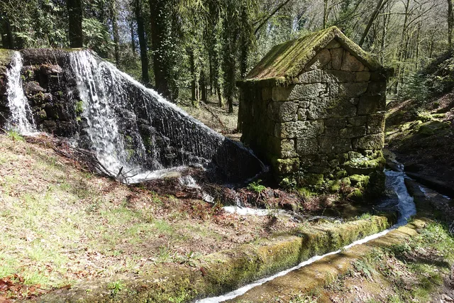
Granite mill served by Levada de Víbora, in all Moinhos de Rei, with waterfall and canal in the wooded surroundings. Register 2025.
A mill and the water channel at Moinhos de Rei.© Joseolgonⓘ

The Levada de Víbora brings nature and human work together.

Includes an activity to try →
Read here and view sources

The Levada de Víbora connects the water’s path with the work of milling. The municipal description of PR1 CBC links its start beside the Oural dam in Abadim to the Moinhos de Rei, woodland and small waterways. It also highlights the village and viewpoint of Porto d’Olho and the Víbora leisure park. The destination is only part of the appeal: the channel helps explain how water was directed and used. To choose the walk, consult the trail profile and compare distance and difficulty; this story does not replace up-to-date information about the route’s condition.

Words in this story: see explanations →Compare the walks See Fact sheet: Moinhos de Rei See Fact sheet: Trilho da Levada de Víbora See Fact sheet: Área de Lazer do Oural See Fact sheet: Área de Lazer de Víbora
Source and context

Municipality — Trilho da Levada de Víbora, PR1 BCC

Accessed: . Editorial summary; the date of consultation is not the date of the facts.

Cavez · landscape described in 1758

A river that powered mills but did not irrigate

Nearby water was not always accessible water.

Includes an activity to try →
Read here and view sources

In 1758, the Tâmega at Cavez was described as a river with plentiful water throughout the year and a particularly strong winter current. It had weirs, channels and grain mills. Along its banks, the account noted cultivated areas, olive groves and trees supporting vines.

Despite that presence in farming life, the vicar stated that the river did not irrigate the parish’s fields: it ran too deep to allow irrigation channels. This is an important difference between having water nearby and being able to direct it to a plot. The description shows how relief shaped water use at that time; it does not describe present-day irrigation.

Getting to know the parish
Source and context

Municipality of Cabeceiras de Basto — Parish memories of 1758: Cavez

Accessed: . Editorial summary; the date of consultation is not the date of the facts.

Saint Nicholas · rivers in 1758

Bridges put to the winter test

Crossing the river was part of everyday life.

Includes an activity to try →Explore: Cross, sail or water? →
Read here and view sources

The São Nicolau account of 1758 describes three wooden bridges. It says that winter waters sometimes covered the two higher ones and even swept some bridges away. This is historical testimony about floods and routes, not a way to assess the safety of today’s crossings. The document names Sendim, Cerdeiró and Ponte do Gado: these crossings helped connect the church with settlements in the parish.

The description goes beyond the force of floods. It mentions a watercourse with many falls, difficult to ford and, in some stretches, even difficult to follow along its banks. The bridges answered that challenge of the terrain.

The Sendim bridge lay on the route from the church to that settlement; the Cerdeiró bridge served the direction of Breia. Ponte do Gado was lower than the other two and gave its name to the point where the branches from Bucos entered. These details connect paths with waterways without fixing every structure’s position on a modern map.

Getting to know the parish
Source and context

Basto Land Museum — St Nicholas Parish Memories (1758)

Accessed: . Editorial summary; the date of consultation is not the date of the facts.

Ribeira de Cavez · water and agriculture

From spring to fields

A stream helps explain an entire landscape.

Read here and view sources

The Cavez stream rises on the municipality’s boundary with Montalegre and ends in the Tâmega. Between mountain and mouth, the municipal description highlights irrigation channels, mills and watered meadows: structures and fields showing different ways of using water.

On the trail starting in Vilela, Rio Douro, the account moves from the descent to the stream towards the irrigation channel and meadow landscape, then along rural tracks and the hillside. Returning to the village brings another material into the story: the granite masonry of its houses. Consult the route profile to prepare your walk; this story explains the landscape without confirming the path’s condition on the day of your visit.

Getting to know the parish See Fact sheet: Trilho da Ribeira de Cavez See Fact sheet: Vilela, Rio Douro
Source and context

Municipality — stream of Cavez and agricultural landscape

Accessed: . Editorial summary; the date of consultation is not the date of the facts.

Toasters · Abadim

A village above a thousand metres

In Torrinheiras, the landscape begins at altitude.

Includes an activity to try →
Read here and view sources

The municipality presents Torrinheiras, in Abadim, as its highest settlement, at around 1020 metres. The trail climbs into the hills and reaches 1159 metres. These are two distinct altitude references: the village and a point on the route, not the walk’s cumulative ascent.

The panorama description names Gerês, Alvão, Marão and Barroso. Lower down, it mentions the Busteliberne stream, Porto d’Olho and, on the return, meadows and grazing Barrosã and Maronesa cattle. The mountains therefore tell a story of distances and views, but also of water, villages and work. Visibility and trail conditions need to be assessed when visiting.

Getting to know the parish See Fact sheet: Trilho de Torrinheiras
Source and context

Municipality — Trilho de Torrinheiras, altitude, landmarks and landscape

Accessed: . Editorial summary; the date of consultation is not the date of the facts.

Rio Douro · Parish memories of 1758

Two rivers tell a parish’s story

The 1758 account describes Rio Douro between east and west.

Includes an activity to try →Explore: Water linking villages and works →
Read here and view sources

In the 1758 account, the Vilela river flowed to the east and the Rio Douro river to the west, both from north to south. The parish priest described their origins in small springs and their waters increasing with contributions from the mountains. He said the Vilela entered the Tâmega below Cavez bridge and the other joined the river coming from São Nicolau. These are the names and geographical relationships in that document, not a current navigation map.

Bridges bring that geography closer to village life. The document mentions a wooden crossing between Magusteiro and Teixugueiras and a stone one between Teixugueiras and the church. It also refers to wooden links from Eiró and Rio Douro to the church, and a stone one between Vilela and the church. Water and paths therefore appear in the same portrait of the parish.

The priest describes rivers with rocks, weirs and waterfalls, unsuitable for navigation but useful to mills and fields. They were more than lines separating places: they belonged to work and travel. These references come from the testimony signed on 22 May 1758; they do not confirm the survival of structures or present access to the banks.

There is a clue to imagining the relief: the author describes three parallel mountain ridges extending from Salto, with rivers in the lower spaces. The ridges’ names varied between places. Rather than seeking a single name for each mountain line, the document invites us to connect position, villages and the direction of water.

Words in this story: see explanations →Getting to know the parish
Source and context

Municipality of Cabeceiras de Basto — Parish memories of 1758: Rio Douro

Accessed: . Editorial summary; the date of consultation is not the date of the facts.

Rio Douro · water uses in 1758

In summer, the water took other paths

Irrigation channels linked river flows to work in the fields.

Includes an activity to try →Explore: Water connected jobs and places →
Read here and view sources

The 1758 account describes both Rio Douro rivers flowing all year but reaching the end of their course with little water in summer. The vicar linked this reduction to the many irrigation channels supplying the fields. Weirs, waterfalls and mills formed a landscape of varied work.

Crossings varied too: the account mentions wooden bridges between settlements and the church, as well as stone bridges at Teixugueiras and Vilela. The banks were not just places of production; people needed to cross from one side to the other. This historical list does not identify surviving structures or current access.

The document also explains why boats did not use the rivers: there were rocks, waterfalls and weirs, as well as insufficient flow for navigation. A river could matter to the parish economy without serving as a waterborne transport route.

On cultivated banks, the account mentions oaks supporting vines; beyond the fields, heather scrub. Water therefore helped organise a landscape where cultivation, vegetation and structures met. The response was signed on 22 May 1758: summer is described as a usual seasonal pattern, not a measurement made that summer.

Words in this story: see explanations →Getting to know the parish
Source and context

Municipality of Cabeceiras de Basto — Parish memories of 1758: Rio Douro

Municipality — Parish Memoirs of Rio Douro, António Carneiro da Costa, 22/05/1758

Accessed: . Editorial summary; the date of consultation is not the date of the facts.

Outeiro · hydrographic network

A small river shapes the map too

In Outeiro, the Trutas joins the Peio.

Includes an activity to try →Explore: A tributary and water works →
Read here and view sources

The municipal description identifies the Trutas as a small tributary of the Peio flowing through Outeiro. Knowing this link helps us see waterways as a network beyond the better-known rivers. The name Trutas, meaning trout, does not in itself confirm those fish are present today.

Outeiro’s position also helps locate this network: the parish occupies the municipality’s western edge, beside Fafe. The municipal description presents a gently rolling plateau, with agriculture among the economic activities mentioned. Reading the territory means bringing these scales together: the municipal boundary, the relief and the small watercourse heading towards the Peio.

Try showing these relationships in a simple drawing. You do not need to reproduce an exact map: an arrow can indicate the rivers’ connection and another mark can place Outeiro on the western side of Cabeceiras.

Words in this story: see explanations →Getting to know the parish
Source and context

Municipality — Outeiro, relief and hydrographic network

Accessed: . Editorial summary; the date of consultation is not the date of the facts.

Alvite · testimony of 1758

Storing water from the hillside

Small springs helped irrigate the fields.

Includes an activity to try →
Read here and view sources

In the 1758 account, the vicar of Alvite described small springs in the Serra da Orada. Residents held this water in pools to benefit east-facing fields. Storing water was a way of dealing with scarcity.

The same document described the parish as dry, particularly in summer, and noted the absence of grain mills and fulling mills. Two olive-oil mills worked with oxen and other animals; to grind cereals, many residents went to neighbouring parishes. The account links natural resources, techniques and journeys without establishing that the same uses or structures survive today.

Getting to know the parish
Source and context

Basto Land Museum — Parish Memories of 1758: Alvite

Accessed: . Editorial summary; the date of consultation is not the date of the facts.

Gondiães e Vilar de Cunhas · memory and landscape

Vilar looks towards the Beça

Houses, hillside and water shape the village landscape.

Includes an activity to try →Explore: From the slope to the paths →
Read here and view sources

The municipal village guide highlights Vilar’s church and thatched buildings on a slope facing the Beça landscape. Its description connects built heritage, farming, livestock and crafts.

Reading that introduction invites you to connect different scales: a house’s roof, the village as a whole and the valley opening before it. This is a way to explore the territory through documented features, not current confirmation of every roof’s condition or access to the river.

The guide grew from a partnership between Cabeceiras de Basto and Vieira do Minho through the Serra da Cabreira Interpretation and Activities Centre. Its introduction seeks to bring visitors closer to the villages and their people. In Vilar, landscape is connected with work: fields, livestock and crafts help us read the place beyond its valley view.

Getting to know the parish
Source and context

Municipality — Village Guide of Serra da Cabreira: landscape, work and heritage

Accessed: . Editorial summary; the date of consultation is not the date of the facts.

Saint Nicholas · testimony of 1758

Water irrigated fields and made olive oil

One river, different kinds of work.

Read here and view sources

In 1758, the parish priest of São Nicolau described irrigation channels serving fields and water powering an olive-oil mill at Quinta da Taipa. One channel served Gondarém, Frágua, Penedo and Lamelas. The account helps us imagine the link between river, irrigation and production. It distinguishes three continuous channels: one for those settlements and two for the estates of Bouças and Taipa. It also mentions mills supplied by weirs.

The description includes a smaller watercourse to the west, originating in springs on the hills of Lapela and Celeiró. On this river, the rector mentions mills and a channel serving the fields of Casal. He recalls two others intended for Quinta da Taipa, one of them ruined. The water-use network therefore included structures in use and others that no longer worked as before.

This detail helps us understand water-powered heritage as ongoing work: a channel’s existence in an old account does not guarantee its use in another period. The source also distinguishes settlements’ shared uses from estate channels, allowing comparison of different relationships between water, fields and owners.

Getting to know the parish
Source and context

Basto Land Museum — St Nicholas Parish Memories (1758)

Accessed: . Editorial summary; the date of consultation is not the date of the facts.

Holy Lady · memory of 1758

The river became part of farming life

A cultivated riverbank tells history too.

Includes an activity to try →Explore: One river, four stories →
Read here and view sources

The 1758 account describes the river of Santa Senhorinha flowing all year, but with little water in summer. It describes cultivated banks, fruit trees and wild trees, linking water with irrigation and rural work.

Vila de Lobos and Cainhos had olive-oil mills; grain mills are mentioned in Vila de Lobos and Sestelo. The same description follows several river uses: growing crops, grinding grain and processing olives. It does not confirm which facilities survive or operate today.

Unlike the rushing currents described at São Nicolau, the abbot characterises this river as calm and flowing from west to east. He begins its course at Aboim and lists Várzea Cova, Passos and São Clemente before Santa Senhorinha. This is the geography reported in the document, not a current delineation of the watercourse.

Residents’ use of water for the fields is described as unrestricted. The account was signed on 23 May 1758. That detail matters: the reference to little water in summer describes a pattern known to the author, not an observation made during that year’s summer.

Words in this story: see explanations →
Source and context

Municipality — Memória de Santa Senhorinha, 23/05/1758; transcript of José Viriato Chapel (2003)

Accessed: . Editorial summary; the date of consultation is not the date of the facts.

Landscape and garden · Painzela

Water shapes the garden at Piellas

Among the clipped shrubs, there are other paths to follow.

Includes an activity to try →Explore: The garden within the landscape →
Read here and view sources

At Piellas, water helps connect garden, woodland and fields. The description published by Revista Jardins places an L-shaped pool beside the wall, near a passage to the Casa do Boal woodland. Another pool, surrounded by bamboo and box, opens towards a cultivated field bordered by woodland. The water continues to the Painzela stream.

The article also describes paths shaded by vine pergolas and a farmyard associated with former maize and wine production. The estate therefore brings together places for leisure and work: its garden of clipped shrubs belongs to a wider landscape.

Try imagining the estate in layers: terraces, paths, vegetation and the water system. The description connects these elements but does not provide a complete map of the water circuit. Piellas is private property; consult the place profile for visiting conditions.

See Fact sheet: Casa de Pielas, jardins e anexos
Source and context

Jardins Magazine — Gardens of Portugal: Route of the Tâmega, section Casa de Piellas

Accessed: . Editorial summary; the date of consultation is not the date of the facts.

Geology of Vila Nune and Gondiães

Not every rock is granite

Vila Nune and Gondiães reveal another part of the geological map.

Explore: The same landscape, different processes →
Read here and view sources

Among the granites, the Archaeological Survey identifies two areas of Palaeozoic metasedimentary rocks. The Vila Nune area extends north-westwards along the Peio; the Gondiães area flanks the Beça. These references help explain the diversity underground; they are not visitor stops or collecting sites. The landscape gains another layer when we consider what it is made of.

To understand the name, separate two stages. Sediments can accumulate, become buried and consolidate into sedimentary rock. If that rock undergoes metamorphism, it changes under conditions such as high temperature and pressure. The term metasediment records this sedimentary origin followed by transformation.

Metamorphism does not mean melting: the USGS explains that transformation happens without the rock becoming magma. Minerals can reorganise or give way to others. In some rocks, elongated or flattened minerals become aligned and form a layered structure called foliation. Not every metamorphic rock has it.

These are tools for interpreting map terminology. They cannot assign a mineral, exact age or specific process to every stone in Vila Nune or Gondiães from its appearance alone. That requires connecting observation with mapping and geological study.

Words in this story: see explanations →
Source and context

Municipality — Archaeological Charter: Orography and geology

British Geological Survey — Rocks and minerals: rock formation, cooling and exposure

U.S. Geological Survey — What are metamorphic rocks?

Accessed: . Editorial summary; the date of consultation is not the date of the facts.

Municipal hydrographic network

The water here reaches the Douro too

The rivers belong to a larger network.

Includes an activity to try →Explore: The way from the water to the Douro →
Read here and view sources

The Ouro, Beça and Cavez stream enter the Tâmega on its right bank; the Tâmega is a tributary of the Douro. The municipal environmental report traces this connection between rivers: a map of Cabeceiras continues far beyond the municipality’s boundaries.

A river basin includes the land that channels water through streams and rivers to a shared outlet to the sea. It is more than a blue line on a map. The APA also distinguishes a sub-basin, whose drainage converges on a point in a watercourse, such as a confluence.

In this story’s diagram, names show connections between waterways, not the boundaries of their basins. To understand a river, we need to include the land that supplies its water. That connection leads from tributaries to soil erosion and life along the banks.

Words in this story: see explanations →
Source and context

Municipality — Environmental Report of the PDM review, February 2025, p. 56

Portuguese Environment Agency — water resources and associated concepts

Accessed: . Editorial summary; the date of consultation is not the date of the facts.

Geology and agriculture · lowlands of the municipality

The river helps explain the fields too

Near the Tâmega, the ground holds another story.

Includes an activity to try →Explore: Same territory, three looks →
Read here and view sources

On low ground near the Tâmega, the Archaeological Survey describes accumulations of sand and clay associated with some of the lowland fields offering the greatest farming potential. The contrast is clear: large granite outcrops dominate the slopes; beside the river, deposited materials help explain another way of farming. The same introduction shows hills descending southwards, with waterways seeking the Tâmega and its tributaries. It is not a soil map of each field, but a key to reading the whole landscape.

Words in this story: see explanations →
Source and context

Municipality — Archaeological Charter: Orography and geology

Accessed: . Editorial summary; the date of consultation is not the date of the facts.

Mineral resources · geological description of the municipality

There is more to a rock than meets the eye

Wolframite and cassiterite are part of Cabeceiras’s geological picture.

Read here and view sources

The municipality’s Archaeological Survey describes a geological setting rich in wolframite and cassiterite. These names add a mineral dimension to the landscape of granite and metasedimentary rocks: they describe the composition underground, beyond the shape of the hills.

Wolframite contains iron, manganese and tungsten. Virtual Microscope, a project involving the Open University and Royal Cornwall Museum, explains its importance as a tungsten ore. Cassiterite is a tin oxide with the formula SnO₂ and an important commercial source of that metal, according to the USGS. They are different minerals associated with different metals.

A mineral is not the same thing as the metal that can be obtained from it. Wolframite is not a piece of metallic tungsten, just as cassiterite is not ready-to-use tin. These names are interesting precisely because they connect matter found in nature with materials transformed by people.

The municipal description confirms the local geological reference. International sources help explain the minerals, but their mining examples belong to other territories. None of these explanations identifies a mine to visit, an active operation or a collecting site here.

Words in this story: see explanations →
Source and context

Municipality — Archaeological Charter: Orography and geology

Open University / Royal Cornwall Museum — Virtual Microscope: Wolframite

USGS — Tin Statistics and Information: cassiterite as a tin source

Accessed: . Editorial summary; the date of consultation is not the date of the facts.

St Nicholas and Painzela · hydrography in the testimony of 1758

Two rivers meet at Ranha

A document lets us follow water between parishes.

Explore: Follow water in document →
Read here and view sources

The 1758 São Nicolau account places the meeting of the river crossing the parish with the one from Painzela at Ponte da Ranha. It then describes their combined flow heading towards the Tâmega near Cavez bridge. This is a historical reading of the water network connecting the territory, not a suggested riverside walk.

Before that meeting, the priest follows São Nicolau’s river from the hill called Víbora. He describes a modest spring receiving other streams, its flow strengthened at Ponte do Gado by two branches from Bucos. He mentions water throughout the year and a particularly strong winter flow.

The text also follows changes of direction: south, then east, then south again. It tells the landscape through the movement of water. Springs, tributaries and confluence explain different stages; the author’s names belong to the testimony signed on 22 May 1758.

Notice the sequence of meetings: the Bucos branches first strengthen São Nicolau’s flow; water from Painzela joins at Ranha; their shared destination is the Tâmega. Drawing these junctions helps distinguish a river’s course from the network of contributions feeding it.

Words in this story: see explanations →
Source and context

Basto Land Museum — St Nicholas Parish Memories (1758)

Accessed: . Editorial summary; the date of consultation is not the date of the facts.

Abadim · intervention in Peio in 2017

Wood, stone and coir on the banks of the Peio

At Ranha, restoring the river also meant choosing materials.

Includes an activity to try →Explore: Taking care of the margins in many ways →
Read here and view sources

At Ranha, the riverbank tells a story of construction too. The work inaugurated on 17 June 2017 combined stone, wood, coir and native plants. According to the municipal news report, it aimed to stabilise the Peio’s banks, restore riverside vegetation and ecologically rehabilitate the leisure area in Abadim.

The work extended to supporting facilities: parking, the building and toilets, the bridge and the road’s retaining wall. Work on the river belonged to a wider project bringing landscape and public use together.

The municipality linked the project to compensation and mitigation measures associated with the Daivões dam, with financial support from Iberdrola. This helps explain the work’s context beyond its visible materials. The report documents 2017; it does not establish that facilities operate today or that the water is suitable for bathing. Consult practical information in Ranha’s place profile.

See Fact sheet: Zona de Banhos da Ranha
Source and context

Municipality — inauguration of the renaturalization of Peio margins, news of 20/06/2017

Accessed: . Editorial summary; the date of consultation is not the date of the facts.

Ribeira de Penoutas · reported intervention in August 2026

Clearing a stream means knowing what to leave

Along the Penoutas stream, ferns are part of the story.

Includes an activity to try →Explore: Water goes through different stories →
Read here and view sources

In August 2026, the municipality described work removing rubbish from the bed and banks and controlling some vegetation. It also highlighted what was preserved: herbaceous plants typical of banks and wetlands, including ferns. This choice shows how stream maintenance can balance water flow with the vegetation alongside it. It is the municipality’s account of that work, without identifying fern species or measuring ecological outcomes.

The report separates tasks that may look alike at a glance: removing litter, controlling scrub and preserving bank plants. It also mentions the aim of improving the space for residents’ use. Cleaning, flow and vegetation are therefore three aspects of the account.

The municipality’s appeal for correct waste disposal connects maintenance with everyday life. Looking at a stream lets us ask not only how water flows but also how people care for the space around it.

Source and context

Municipality — cleaning action in the Penoutas River, 07/08/2026

Accessed: . Editorial summary; the date of consultation is not the date of the facts.

Rio Douro · project announced in April 2025

On the common lands, woodland meets waterways

A Rio Douro project reveals different roles within one landscape.

Includes an activity to try →Explore: The slope meets the river →
Read here and view sources

In April 2025, Antarr announced the start of work agreed with the Comunidade Local dos Baldios de Riodouro, covering around 500 hectares of Cabreira partly affected by the 2016 and 2024 fires. The plan combined forestry production, conservation and the restoration of about 40 hectares of riverside vegetation. It shows that managing a hillside also involves areas beside water. These figures are the promoter’s announced targets, not confirmation of completed work or achieved results.

The April announcement places the start of work in February 2025. For the first phase, it announces around 220 hectares of production species and approximately 80 hectares of varied broadleaved trees and conifers. These areas have different purposes; they are not a record of completed planting.

Relief also enters the project: the promoter describes plateaux, steep slopes and large variations in altitude. Reading the landscape therefore brings together landform, production areas and sensitive zones beside water. There is no complete breakdown of the 500 hectares here from which to draw every plot.

Source and context

Antar — announcement of the start of the Riodouro project, 04/04/2025; objectives announced by the promoter

Accessed: . Editorial summary; the date of consultation is not the date of the facts.

Refojos · opening in 2013 and urban transformation

A stream in the story of Casa do Tempo

Renewing the town centre also involved water.

Includes an activity to try →Explore: Memory, buildings and water →
Read here and view sources

Casa do Tempo opened on 2 August 2013 beside the Monastery of Refojos. In the municipal description, restoring former tenant farmers’ houses belonged to a wider transformation: linking Praça da República with newer parts of town, creating green spaces and improving the banks of the Penoutas stream. The interpretation centre therefore brings two stories together: Cabeceiras’s memory and the changing urban landscape.

The municipality describes acquiring some of the vacant houses and the negotiations preceding the work. Reusing buildings and transforming their surroundings appear as parts of one project rather than separate stories.

The centre’s multimedia component was presented as a way to explore territory, people, nature, customs and everyday practices. The stream is therefore more than scenery: it belongs to the story of how this part of town gained new functions. For planning a visit, the place profile brings together available practical information.

See Fact sheet: Casa do Tempo
Source and context

Municipality — Casa do Tempo: opening in 2013 and requalification of the surroundings

Accessed: . Editorial summary; the date of consultation is not the date of the facts.

Saint Nicholas and Painzela · testimony of 1758

A bridge for loaded carts

Three springs and a crossing connected two parishes.

Includes an activity to try →Explore: Pass, water and grind →
Read here and view sources

In 1758, the parish priest describes a small river rising from three springs on the hills of Lapela and Celeiró. It entered Painzela through Vilarinho, where a wooden bridge supported loaded carts. The testimony does not identify a crossing that can be visited today.

The same river also powered mills and supplied an irrigation channel for the fields of Casal. The author recalls two other diversions linked to the Taipa estate, one already ruined when the account was written.

This description brings together transport, milling and irrigation. A bridge allowed crossing; a channel diverted some water to another use. Their functions were not equivalent, although they belonged to the same working landscape. The reference to a ruined structure also shows that the document records changes and losses alongside what was working.

Words in this story: see explanations →
Source and context

Basto Land Museum — St Nicholas Parish Memories, 22 May 1758

Accessed: . Editorial summary; the date of consultation is not the date of the facts.

Saint Nicholas · environmental history of 1758

Fish that entered the written record

An old document also describes life in the rivers.

Includes an activity to try →Explore: Three Ways to Know a River →
Read here and view sources

The São Nicolau account lists trout and fish called bogas and escalos in the main river, in small numbers. In the smaller watercourse, it mentions small trout. These are names used in the 1758 document, not scientific identifications or confirmation of present populations.

Domingos Camelo de Sousa distinguishes the watercourses before discussing fish. The main one received two branches from Bucos near Ponte do Gado; the smaller one rose in springs on the hills of Lapela and Celeiró and continued to Painzela. This location gives context to the animal names. The account also comments on the fishes’ taste, revealing a view connected with food rather than the method of a biological survey.

Source and context

Basto Land Museum — St Nicholas Parish Memories, 22 May 1758

Accessed: . Editorial summary; the date of consultation is not the date of the facts.

Faia · municipal description of the settlement

A road helps explain Faia

Not every settlement grows around a single centre.

Includes an activity to try →
Read here and view sources

In the south of the municipality, beside the boundary with Celorico de Basto, the municipality describes Faia through its proximity to Arco de Baúlhe and the distribution of settlement along the EN 206. The road helps explain a pattern of occupation that is not confined to a single centre.

The introduction connects access, farming, wine-growing and crafts such as cooperage and handmade footwear. To discover the parish, connect houses and paths with these memories of work. This reading of the municipal source does not replace current mapping or identify open workshops.

Source and context

Municipality — presentation of Faia: settlement and traditional activities

Accessed: . Editorial summary; the date of consultation is not the date of the facts.

Geological complex of Cabeceiras de Basto · regional study

Granite varies in grain size too

A seemingly uniform rock can reveal differences up close.

Includes an activity to try →
Read here and view sources

In A. Almeida’s study, granite from the Cabeceiras de Basto complex does not have a single grain size. The classification uses three average ranges: 0.5–1 millimetre for fine grain, 2–4 millimetres for medium grain and 5–7 millimetres for coarse grain. In the last group, the author also mentions rare larger crystals measuring 8–10 millimetres.

This distinguishes two observations: the usual grain size and the presence of a few crystals that stand out. The description does not turn every visible point in a photograph into a measurement. Comparing sizes in an image requires a scale; magnification on a screen can make small grains look large.

The study identifies three genetically independent series despite their similar chemical-composition ranges. Appearance is a starting point for investigation, not the entire explanation of origin. In a wall or façade, grains spark curiosity, but do not alone prove where the stone came from.

Words in this story: see explanations →
Source and context

A. Almeida (1998) — Metallurgical specialisation of the peraluminous granites of two micas of the Cabeceiras de Basto complex, IGM 84(1), B-79–B-82; p. 325 of the PDF

Accessed: . Editorial summary; the date of consultation is not the date of the facts.

Geological complex of Cabeceiras de Basto · dating cited in the study

A story millions of years old

A rock’s age and a landscape’s shape are different questions.

Explore: Three questions for the same stone →
Read here and view sources

A. Almeida’s paper refers to dating the Cabeceiras de Basto complex by the uranium–lead method, using zircon and monazite. The cited result is a minimum age of 311 ± 1 million years. This is a geological reference to the rock formation studied: it does not date the construction of a wall or establish when a hillside acquired its present shape.

The article forms part of the proceedings of the fifth National Geology Congress, published in 1998. For this value, Almeida refers to geochronological work with other authors listed in the bibliography. This chain of references explains where the number comes from: a research result, not an age estimated from colour or grain size.

Reading a landscape means separating timescales. The age assigned to a rock complex is one matter, the transformation of the relief another, and the moment a stone was used in a building another still. All three stories can meet in the same wall, but they require different evidence.

Source and context

A. Almeida (1998) — Metallurgical specialisation of the peraluminous granites of two micas of the Cabeceiras de Basto complex, IGM 84(1), B-79–B-82; p. 325 of the PDF

Accessed: . Editorial summary; the date of consultation is not the date of the facts.

General geology · reading of granite texture

Small grains tell how the rock cooled

Granite contains minerals you can distinguish by eye.

Includes an activity to try →
Read here and view sources

Adão Mendes’s explainer for the Portuguese Association of Biology and Geology Teachers links granite’s granular texture with magma cooling slowly at depth. Its characteristic minerals include quartz and feldspars; micas may also be present. This general explanation encourages a closer look at stone, but recognising colours and grains is not enough to identify a sample’s origin.

If granite formed at depth, how do we see it in an outcrop? The British Geological Survey links its exposure to uplift, erosion and weathering over millions of years. Formation and exposure at the surface are different stages in its story.

It also helps to distinguish rock from mineral. In granite, different minerals occur together as interlocking crystals. Recognising that combination differs from observing a single mineral in isolation. Relative crystal sizes and their arrangement help describe texture; one colour does not tell the rock’s whole story.

Source and context

Adam Mendes / APPBG — Characterize basalt, gabro, andesite, diorite, riolite and granite; RTP Teach, 2020

British Geological Survey — Rocks and minerals: rock formation, cooling and exposure

Accessed: . Editorial summary; the date of consultation is not the date of the facts.

Council · Water resources in the 2025 report

There is water beneath the ground too

The map of water resources does not end at the surface.

Includes an activity to try →Explore: Look at the water in different ways →
Read here and view sources

For groundwater, the municipal environmental report of February 2025 identifies units of the Undifferentiated Ancient Massif associated with the Douro, Ave and Cávado basins. In the same document, the municipality’s surface-water bodies belong to the Douro River Basin District. These are different readings of the territory: rivers at the surface and water underground. The reference does not identify wells to visit or assess the water in any spring.

How does water fit inside rock? The USGS explanation points to pores and fractures: spaces between particles and cracks that can contain water. Porosity describes the available spaces; permeability describes how easily water flows through the material. Spaces alone are not enough: the connections between them matter too. This is a general explanation, not a measurement of Cabeceiras’s rocks.

Source and context

Municipality — Environmental Report of the PDM review, February 2025, pp. 56–58: water network and resources

USGS — Water Science School: groundwater, porosity and permeability

Accessed: . Editorial summary; the date of consultation is not the date of the facts.

Refojos and São Nicolau · uses described in 2025

Water brings power and irrigates fields

One landscape brings together different uses.

Explore: From moving water to electricity →
Read here and view sources

The 2025 environmental report connects water resources with electricity production and irrigation. It identifies the Cefra hydroelectric plant in Refojos and the small hydropower plant at São Nicolau. These are documentary references to water uses, without confirmation of public access or current operation. Connect them with the stories of mills and irrigation channels: the relationship between water and work spans different periods.

How does a current become electricity? Water turns a turbine connected to a generator. Flow and height difference influence the available energy, explains the Department of Energy. This is the general principle explored by the diagram, not a description of the specific equipment at either local installation. Irrigating fields, grinding grain and generating electricity are different uses of a resource connected with the landscape.

Words in this story: see explanations →
Source and context

Municipality — Environmental Report of the PDM review, February 2025, pp. 56–58: water network and resources

U.S. Department of Energy — How Hydropower Works: turbine, generator, flow and downgrade

Accessed: . Editorial summary; the date of consultation is not the date of the facts.

Climate of the municipality · characterization in the report of 2025

The landscape follows a rhythm of rain and warmth

The same place tells different stories throughout the year.

Includes an activity to try →Explore: The same landscape, different questions →
Read here and view sources

The 2025 environmental report describes colder, wetter winters, with the most rain in December and January, and warmer, drier summers. July and August stand out for their heat. This describes the climate, not the forecast for your next visit. To get to know a place, compare it in different months: water, leaves and flowers can offer new clues.

How is that picture built? The IPMA explains that climatological normals use 30-year periods. They bring together monthly and annual values for elements such as temperature and precipitation. A single month and a decades-long series therefore answer different questions.

When comparing charts, look for the location and reference period: averages calculated over different intervals need not coincide. Long series allow variations and trends to be studied. Observations on a walk help you know that day and place; they do not replace a climate series or, on their own, describe every altitude in the municipality.

Words in this story: see explanations →
Source and context

Municipality — Environmental Report, February 2025, pp. 50, 55 and 139

IPMA — Climate normals: periods and reference values

Accessed: . Editorial summary; the date of consultation is not the date of the facts.

Abadim · water and grinding in memory 1758

Two streams kept six mills working

Even a little water could keep a landscape moving.

Includes an activity to try →Explore: From water to food →
Read here and view sources

In 1758, the abbot of Abadim describes two streams descending southwards, meeting near Ponte de Pé and continuing to the Tâmega. There was little water, but it flowed all year. The account mentions trout and fish called bogas without identifying species by scientific names.

On the western stream, he notes Ranha’s dressed-stone bridge. Of the various mills on the two waterways, six belonged to the parish. This count identifies neither today’s buildings nor whether they were the same mills as the group now called Moinhos de Rei.

The abbot describes swift currents and neighbouring communities’ free use of the water. Little water and movement were therefore not incompatible in his account. The story gains another dimension beside the fields: the same document distinguishes cereals grown in different settlements. The streams belonged to a landscape of cultivation and processing, although the account does not say which mill received each village’s grain.

Words in this story: see explanations →
Source and context

Municipality — Parish memories of Abadim, José Antunes, 22/05/1758

Accessed: . Editorial summary; the date of consultation is not the date of the facts.

Council · environmental relations described in the report of 2025

A river begins before its banks

What happens on the land can travel with the water.

Includes an activity to try →Explore: Follow water to the surface and underground →
Read here and view sources

Water flowing over the surface can carry soil and nutrients into waterways. The municipal environmental report of February 2025 connects this process with erosion and incorrect use of fertilisers rich in phosphorus and nitrogen. Excessive nutrient enrichment can encourage eutrophication, changing the aquatic environment.

The document also distinguishes groundwater: it notes that excessive use of nitrogen fertilisers can contribute to nitrate accumulation and increased salinity. What happens on the land therefore matters both to the water we see flowing and to water underground.

These are potential pressures described in an environmental assessment. They do not identify a discharge in a particular field or let us assess a river by appearance. To understand the system, connect land, surface runoff and aquifers while keeping general possibilities separate from measurements at a site.

Source and context

Municipality — Environmental Report of the PDM review, February 2025, p. 59: land uses and water resources

Accessed: . Editorial summary; the date of consultation is not the date of the facts.

Gondiães · 2008 municipal inventory

Four pools and a shared irrigation channel

In Gondiães, storing and directing water was collective work.

Includes an activity to try →Explore: Store, drive and distribute →
Read here and view sources

Four pools supplied a shared structure. The municipal record of 20 March 2008 describes the Rego das Poças, also called Levada da Vizinhança, in Gondiães: around two kilometres of channel for irrigation and milling, serving the Tarroeiro mill.

The Poças do Lugar lay at Olheiros. Three were close together and the fourth further away. Up to the village entrance, the channel followed natural ground; within the settlement it became a stone trough. Storing and directing water therefore required different elements and materials.

The inventory identifies collective ownership and operation by the channel’s joint users, or consortes. It records seasonal water turns but leaves the construction period undetermined. The survey date is not the structure’s age. Its recorded use and condition belong to the picture of 2008, without confirming today’s situation or access.

Words in this story: see explanations →
Source and context

Municipality — inventory of levadas, fiche L29: Rego das Poças, withdrawal of 20/03/2008

Accessed: . Editorial summary; the date of consultation is not the date of the facts.

Saint Nicholas · hydraulic heritage inventoryed in 2008

A hollowed log channelled the water’s power

At Quinta de Covas, olive oil’s history meets the story of energy.

Explore: Water changes work →
Read here and view sources

The inventory of 27 February 2008 places the Quinta de Covas mill at Parada, in Cabeceiras de Basto parish. Water came from a channel with a weir on the Peio. Before reaching the horizontal waterwheel, it passed along a trough hollowed from a tree trunk: wood also formed part of this water-powered structure.

The building combined an olive-oil mill, a grain mill and a wine press. The record associates the closure of the grain and olive-oil mills in 1994 with a hydroelectric plant coming into operation and affecting the available motive power. This is the explanation recorded in that survey, not an independent assessment of the plant’s operation.

The document describes private heritage and equipment already lacking the parts needed for grinding. This story indicates neither public access nor present conservation conditions.

Source and context

Municipality — inventory of olive oil mills, record L.A.5, withdrawal of 27/02/2008

Accessed: . Editorial summary; the date of consultation is not the date of the facts.

Cabeceiras de Basto · windmill architecture studied in 2011

Grinding above, movement below

A mill is organised vertically too.

Includes an activity to try →Explore: From the water to the building →
Read here and view sources

The study shared by the Museum in 2011 describes two levels in Cabeceiras’s mills: the grinding equipment above and the driving mechanism below, in the cabouco. The building’s form follows how the machinery works. The survey records rectangular plans of varying sizes, with the exception of one circular-plan watermill.

Granite dominates the walls, but not every stone receives the same treatment. The study highlights points with particular construction demands: corners, doors, windows and parts through which water passes. At the corners, stones help bond the building together; lintels and jambs frame the openings. An irregular-looking wall can therefore coexist with carefully selected pieces.

This description belongs to the historical study, not an inspection of today’s buildings. To read the landscape, start with the water’s route, then ask where the driving force and the grinding work were located.

Words in this story: see explanations →
Source and context

Basto Land Museum — Mills Cabeceiras de Basto: construction form, 04/05/2011

Accessed: . Editorial summary; the date of consultation is not the date of the facts.

YOUR LOCAL GUIDE

What would you like to discover?

Take a closer look.