Discover Cabeceiras de BastoFree independent guide
ViveCabeceirasYOUR GUIDE TO CABECEIRAS
ENEnglish
SearchSaved

Stories of Cabeceiras

Choose a story to start with. You can change the subject or fine tune the search.

36 stories · All themes · Search: moinhos

Between rivers and mountains

Water and relief form the municipality. Choose a name and follow the landscape.

Choose a story · 16
Abadim · water and grinding in memory 1758

Two streams worked six mills

Few water could also keep a landscape moving.

Includes an activity to try →Explore: From water to food →
Read here and view sources

In 1758, the abbot of Abadim described two streams that went down south, were near Ponte de Pé and went to Tâmega. The water was small, but ran all year round. The report mentions trouts and bogs, without identifying species with scientific names.

In the regato a poente, marks the bridge of cantaria da Ranha. Of the several mills existing on the two water lines, six belonged to the parish. This count does not identify the current buildings nor allows to conclude that they were the same as the assembly today called Moinhos de Rei.

The Abbot describes rapid currents and free use of the waters by neighboring peoples. Thus, little water and movement were not incompatible ideas in his portrait. Reading gains another dimension when approaching the fields: the same document distinguishes the cereals produced in the various places. The regattos belonged to a landscape of cultivation and transformation, although memory does not tell which mill received the cereal from each village.

Words in this story: see explanations →
Source and context

Municipality — Parish memories of Abadim, José Antunes, 22/05/1758

Accessed: . Editorial summary; the date of consultation is not the date of the facts.
Bucos · testimony of 1758

Two rivers lost their name

The water connected the mountains, the mills and the fields.

Includes an activity to try →Explore: Follows water of Bucos →
Read here and view sources

The vicar of Bucos described in 1758 two courses that eventually lost their name when entering the river of São Nicolau. One was Porto Souto, coming from the mountains of the Apple; the other, called the river of Millos, had origins referred to in Carrazedo and Figueiró do Monte.

The report combines water and work: cultivated margins, grain mills and water use in agriculture. It also mentions small wooden frames. Reading these elements together helps to imagine the links between fields, crossings and grinding. The names and uses belong to the document of 1758; they do not automatically identify the courses or structures that are on the ground today.

Porto Souto is described running all year, despite the reduced flow, with small falls on the north to south route. The other course had a more serene current. The vicar registers trouts and escalates in both: his attention passes from the movement of water to the fish and from there to the cultivated shores. It is not necessary to imagine a large river to understand the importance of these water lines in the life of the parish.

The text also allows us to compare two crossing scales: the Casares bridge, on a busy road, and pedestrian passages made with a single wooden beam. The author highlights the need to improve the first one. The river is thus linked both to the daily work of farmers and to the circulation out of the parish.

Getting to know the parish
Source and context

Municipality — Parish memories of Bucos (1758)

Accessed: . Editorial summary; the date of consultation is not the date of the facts.

Cabeceiras de Basto · windmill architecture studied in 2011

Above, the grinding; below, the movement

A mill is also organized vertically.

Includes an activity to try →Explore: From the water to the building →
Read here and view sources

The study published by the Museum in 2011 describes two levels in the mills of Cabeceiras: above is the mill; below, in the cabouco, the motor mechanism. The form of the building accompanies the operation of the mill. The survey records rectangular plants of varied dimensions, with the exception of a circular plant sour.

The granite dominates the walls, but not all the stone receives the same treatment. The study highlights the points subject to constructive requirements: corners, doors, windows and elements through which the water passes. In the wedges, the stones help to lock the construction; pads and shoulder pads frame the spans. An irregular wall can thus coexist with carefully chosen pieces.

This description belongs to the historical study, not to an inspection of the current buildings. To read the landscape, start with the route of the water and then ask where were the motor force and the work of grinding.

Words in this story: see explanations →
Source and context

Basto Land Museum — Mills Cabeceiras de Basto: construction form, 04/05/2011

Accessed: . Editorial summary; the date of consultation is not the date of the facts.

Saint Nicholas · hydraulic heritage inventoryed in 2008

Peio also made flour

A river connected fields, dams and mills.

Includes an activity to try →
Read here and view sources

The Levada do Casal record records water captured at Peio, near Ponte do Gado, in Gondarem. The inventory describes five mills along the canal. It is a portrait of the hydraulic heritage, not a confirmation of current operation or public access.

The survey of 26 of February 2008 identifies a channel in natural land and two consorts: Casa do Casal and Quinta do Boyinho, this one with less watering time. It also describes the layout near the Levada de Bouças and a landmark in Sendim placed to resolve a divergence of enjoyment. The channel carried water, but its use also depended on agreements between people.

Source and context

Municipality — inventory of taken, L1 and L18 forms (uplifts of 2008)

Accessed: . Editorial summary; the date of consultation is not the date of the facts.

Rio Douro · Parish memories of 1758

Two rivers to count a parish

The report of 1758 organizes Rio Douro between spring and west.

Includes an activity to try →Explore: Water linking villages and works →
Read here and view sources

In the account of 1758, the Vilela River ran the spring and the river from Rio Douro to the west, both from north to south. The parish priest described origins in small sources and the increase in waters with the contributions of the mountains. He said that Vilela entered the Tâmega below the bridge of Cavez and that the other joined the river coming from São Nicolau. They are geographical names and relations of that document, not a current navigation map.

The bridges bring this geography closer to the life of the villages. The document mentions a wooden crossing between Magusteiro and Teixeiras and a stone one between Teixeiras and the church. It also mentions wooden connections of Eiró and Rio Douro to the church, and another stone between Vilela and the church. Water and paths appear, thus, in the same portrait of the parish.

The parish priest describes rivers with rocks, dams and waterfalls, inadequate to navigation, but useful to mills and fields. They were not only lines to separate places: they were part of work and displacements. These references belong to the testimony signed in 22 May 1758; they do not confirm the conservation of structures or the current access to the margins.

There is a clue to imagine the relief: the author describes three parallel mountains, extended from Salto, with the rivers in the lower spaces. The names of the mountains varied according to the places. Instead of looking for a single name for each mountain line, the document invites to relate position, villages and direction of the water.

Words in this story: see explanations →Getting to know the parish
Source and context

Municipality of Cabeceiras de Basto — Parish memories of 1758: Rio Douro

Accessed: . Editorial summary; the date of consultation is not the date of the facts.

Holy Lady · memory of 1758

The river entered the life of the fields

A cultivated margin also tells history.

Includes an activity to try →Explore: One river, four stories →
Read here and view sources

The memory of 1758 describes the river of Santa Senhorinha running all year round, but with little water in summer. The memory describes cultivated shores, fruit trees and wild grove, linking water to irrigation and rural work.

Vila de Lobos and Cainhos had olive oil mills; the mills are referred to in Vila de Lobos and Sestelo. The same description allows following various uses of the river: to cultivate, grind and transform the olive. It does not confirm which of these equipment survive or operate today.

Unlike the precipitated currents described in São Nicolau, the abbot characterizes this river as quiet and oriented from sunset to spring. He begins his journey in Aboim and lists the passage by Várzea Cova, Passos and St Clemente before arriving in Santa Senhorinha. It is the geography reported in the document, not a current demarcation of the course.

The use of water for the fields is presented as free for residents. The relationship was signed on 23 May 1758. This detail is important: the indication of little water in the summer describes a pattern known to the author, not an observation made in the summer of this year.

Words in this story: see explanations →
Source and context

Municipality — Memória de Santa Senhorinha, 23/05/1758; transcript of José Viriato Chapel (2003)

Accessed: . Editorial summary; the date of consultation is not the date of the facts.

Saint Nicholas and Painzela · testimony of 1758

A bridge for loaded cars

Three springs and a crossing connected two parishes.

Includes an activity to try →Explore: Pass, water and grind →
Read here and view sources

In 1758, the parish priest describes a small river born from three sources in the hills of Lapela and Celeiró. It entered in Painzela by Vilarinho, where a wooden bridge supported loaded cars. The testimony does not identify a visitable crossing today.

The same river also moved mills and provided water to one taken to the fields of Casal. The author recalls two other derivations linked to the Taipa farm, one of them already ruined at the time of the report.

This description combines transport, grinding and watering. A bridge allowed to pass; a levada diverted part of the water to another use. They were not equivalent functions, although they participated in the same work landscape. The reference to a ruined structure also shows that the document records changes and losses, in addition to what was in operation.

Words in this story: see explanations →
Source and context

Basto Land Museum — St Nicholas Parish Memories, 22 May 1758

Accessed: . Editorial summary; the date of consultation is not the date of the facts.

Saint Nicholas · hydraulic heritage inventoryed in 2008

A log led the force of the water

In Quinta de Covas, the history of olive oil intersects with that of energy.

Explore: Water changes work →
Read here and view sources

The inventory of 27 of February 2008 located the mill of Quinta de Covas in Parada, in the parish of Cabeceiras de Basto. The water came from a levada with a weir in Peio. Before arriving to the castor, it passed through a gutter excavated in a trunk: wood was also part of this hydraulic construction.

The building brought together an olive oil mill, a mill and a wine mill. The form associates the decommissioning of the mill and the mill in 1994 to the entry into operation of a hydroelectric power station, which conditioned the available motor force. It is the explanation recorded in that survey, not an independent evaluation of the operation of the plant.

The document describes private heritage and equipment already without the necessary elements for grinding. This story does not indicate public access or current conditions of conservation.

Source and context

Municipality — inventory of olive oil mills, record L.A.5, withdrawal of 27/02/2008

Accessed: . Editorial summary; the date of consultation is not the date of the facts.

Landscape · Abadim

Follow the path of the water

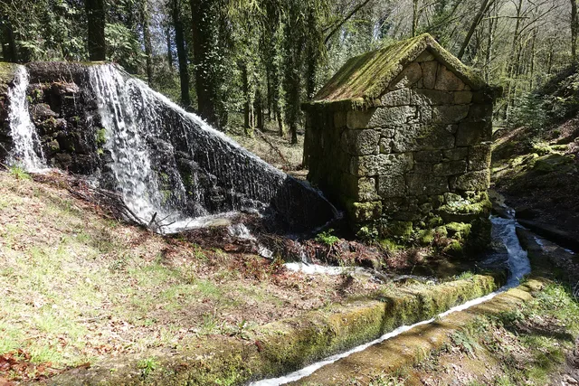
Granite mill served by Levada de Víbora, in all Moinhos de Rei, with waterfall and canal in the wooded surroundings. Register 2025.
A mill and the water channel at Moinhos de Rei.© Joseolgonⓘ

The Levada de Víbora approaches nature and human labor.

Includes an activity to try →
Read here and view sources

The Levada de Víbora allows you to relate the water path to the grinding work. The municipal presentation of the PR1 BCC connects the beginning to the Oral Dam, in Abadim, to the Moinhos de Rei, to woods and small watercourses. It also highlights the village and viewpoint of Porto d’Olho and Leisure Park of Víbora. Interest is not only in the destination: the channel helps to understand how the water was conducted and used. To choose the walk, see the track record and compare distance and difficulty; this reading does not replace the current conditions of the route.

Words in this story: see explanations →Compare the walks See Fact sheet: Moinhos de Rei See Fact sheet: Trilho da Levada de Víbora See Fact sheet: Área de Lazer do Oural See Fact sheet: Área de Lazer de Víbora
Source and context

Municipality — Trilho da Levada de Víbora, PR1 BCC

Accessed: . Editorial summary; the date of consultation is not the date of the facts.

Cavez · landscape described in 1758

A river that moved but did not water

The water nearby was not always accessible water.

Includes an activity to try →
Read here and view sources

In 1758, the Tâmega was described in Cavez as a caudal river throughout the year, with a particularly strong current in winter. It had dams, canals and cereal mills. On the banks, the report pointed out cultivated areas, olive groves and trees that supported vineyards.

Despite this presence in agricultural life, the vicar said that the river did not water the fields of the parish: it ran too deep to allow levadas. It is an important difference between having water nearby and being able to lead it to a portion. The description shows how the relief conditioned the uses of water at that time; it does not characterize the current irrigation.

Getting to know the parish
Source and context

Municipality of Cabeceiras de Basto — Parish memories of 1758: Cavez

Accessed: . Editorial summary; the date of consultation is not the date of the facts.

Ribeira de Cavez · water and agriculture

From the spring to the fields

A stream helps explain the whole landscape.

Read here and view sources

The brook of Cavez is born on the border of the municipality with Montalegre and ends at Tâmega. Between the mountain and the mouth, the municipal description highlights levadas, mills and irrigation mills: buildings and fields that show different ways to enjoy the water.

On the trail beginning in Vilela, Rio Douro, the narrative goes from the descent to the riverside to the levada and the landscape of the lameiros, then following rural paths and the slope. The return to the village brings another material to the history: the granite masonry of the houses. See the route chart to prepare the walk; this reading explains the landscape, without confirming the conditions of the way on the day of the visit.

Getting to know the parish See Fact sheet: Trilho da Ribeira de Cavez See Fact sheet: Vilela, Rio Douro
Source and context

Municipality — stream of Cavez and agricultural landscape

Accessed: . Editorial summary; the date of consultation is not the date of the facts.

Rio Douro · water uses in 1758

In summer, the water took other paths

The levadas linked the flow of rivers to the work of the fields.

Includes an activity to try →Explore: Water connected jobs and places →
Read here and view sources

The memory of 1758 describes the two rivers of Rio Douro running all year round, but arriving at the end of the course with little water in the summer. The vicar linked this decrease to the many levadas that supplied the fields. Dams, waterfalls and mills comprised a landscape of various works.

The crossings also varied: the report mentions wooden bridges between places and the church, as well as stone bridges in Teixeiras and Vilela. The margins were not just production spaces; it was necessary to move from one side to the other. This historical enumeration does not identify surviving structures or current accesses.

The document also explains why boats did not circulate: there were stones, waterfalls and dams, and insufficient flow for navigation. A river could be important for the economy of the parish without being a river transport route.

On the cultivated shores, the report mentions vine oaks; outside the fields, urzeira forests. Thus, the water helped to organize a landscape in which cultivation, vegetation and equipment were found. The answer was signed in 22 May 1758: summer is described as usual behavior, not as a measurement carried out this summer.

Words in this story: see explanations →Getting to know the parish
Source and context

Municipality of Cabeceiras de Basto — Parish memories of 1758: Rio Douro

Municipality — Parish Memoirs of Rio Douro, António Carneiro da Costa, 22/05/1758

Accessed: . Editorial summary; the date of consultation is not the date of the facts.
Alvite · testimony of 1758

Store water coming from the hill

Small springs helped water the fields.

Includes an activity to try →
Read here and view sources

In the ratio of 1758, the vicar of Alvite described little abundant springs in the Serra da Orada. The residents retained these waters in prey to benefit the fields facing the spring. Saving water was a way to cope with its scarcity.

The same document classified the parish as drought, especially in the summer, and referred to the absence of mills and mills. Two olive oil mills worked with oxen and other animals; to grind cereals, many residents sought neighboring parishes. The portrait links natural resources, techniques and displacements, without allowing to conclude that the same uses or structures continue today.

Getting to know the parish
Source and context

Basto Land Museum — Parish Memories of 1758: Alvite

Accessed: . Editorial summary; the date of consultation is not the date of the facts.
Saint Nicholas · testimony of 1758

The water watered and made oil

A river, different jobs.

Read here and view sources

In 1758, the parish priest of São Nicolau described taken to the fields and water to move an oil mill in Quinta da Taipa. One of the levadas served Gondarem, Fragua, Penedo and Lamelas. The report helps to imagine the link between river, irrigation and production. It distinguishes three continuous levadas: one for the places referred to and two for the farms of Bouças and Taipa. It also mentions mills fed by dams.

The description also includes a smaller water course, the west, originating in the fountains of the hills of Lapela and Celeiró. In this river, the rector mentions mills and a levada that served the fields of the Casal. He recalls two other destined to Quinta da Taipa, one of which was ruined. The water use network had therefore structures in use and others that no longer worked as before.

This detail helps to read the hydraulic heritage as continuous work: the existence of a canal in an old account does not guarantee its use in another time. The source also distinguishes collective uses from places and taken from farms, allowing to compare different relationships between water, fields and owners.

Getting to know the parish
Source and context

Basto Land Museum — St Nicholas Parish Memories (1758)

Accessed: . Editorial summary; the date of consultation is not the date of the facts.

Refojos and São Nicolau · uses described in 2025

Water also reaches the light and fields

The same landscape brings together different uses.

Explore: From moving water to electricity →
Read here and view sources

The environmental report of 2025 relates water resources to electricity production and irrigation. It identifies the Cefra Hydropower Plant in Refojos, and the São Nicolau mini-hydric. They are documentary references to water use, without confirmation of public access or current operation. Add to them the stories of mills and levadas: the relationship between water and work goes through different times.

How does it go from current to electricity? Water runs a turbine connected to a generator. Flow and downgrade influence the available energy, explains the Department of Energy. It is the general principle that the scheme allows you to explore; it does not describe the specific equipment of the two local facilities. Thus, watering fields, grinding cereal and producing electricity are different uses of a resource connected to the landscape.

Words in this story: see explanations →
Source and context

Municipality — Environmental Report of the PDM review, February 2025, pp. 56–58: water network and resources

U.S. Department of Energy — How Hydropower Works: turbine, generator, flow and downgrade

Accessed: . Editorial summary; the date of consultation is not the date of the facts.

Gondiães · 2008 municipal inventory

♪ Four puddles, a neighborhood runaway ♪

In Gondiães, water storage and driving was part of the collective work.

Includes an activity to try →Explore: Store, drive and distribute →
Read here and view sources

Four puddles fed a common infrastructure. The March 20 record of 2008 describes the Rego das Poças, also called Levada da Neighbourhood, in Gondiães: about two kilometres of canal for irrigation and milling, serving the mill of the Tarroeiro.

The Puddles of the Place were located in the Scouts. Three were close to each other; the fourth, farther away. Up to the entrance of the village, the canal followed on natural ground; inside the place passed the stone strut. Store and conduct the water required, therefore, different elements and materials.

The inventory identifies collective ownership and exploitation by the levada consorts. It records seasonal shifts of water, but leaves the time of undetermined construction. The date of the survey is not the age of the work. The indication of use and the state of conservation belong to the portrait of 2008, without confirming the current situation or access.

Words in this story: see explanations →
Source and context

Municipality — inventory of levadas, fiche L29: Rego das Poças, withdrawal of 20/03/2008

Accessed: . Editorial summary; the date of consultation is not the date of the facts.

Life you do not always see

Knowing animals begins by perceiving the territory and respecting the distance.

Choose a story · 1
Interpretation centre

A first encounter at Moinhos de Rei

Learn about Cabreira before heading into the countryside.

Explore: From interpretation to discovery →
Read here and view sources

The Núcleo Interpretativo de Vida Selvagem opened on 31 August 2013 in Abadim. The municipal presentation explains its connection with the fauna and flora of Serra da Cabreira and with raising awareness of the forest. Consult the place profile to prepare your visit.

The building has a history too: the municipal presentation places the centre in a small annex previously used by the Social Services. Its new role brought learning about animals and plants together with an appreciation of the forest and local customs.

It is a starting point for asking questions about the landscape: how are scrub, trees and animals connected? The following stories let you continue exploring at home. Learning about a species or habitat does not guarantee a sighting during a visit.

See Fact sheet: Núcleo Interpretativo de Vida Selvagem
Source and context

Municipality — Núcleo Interpretativo de Vida Selvagem

Accessed: . Editorial summary; the date of consultation is not the date of the facts.

Crafts and memories

In the hands, at the table and in the community: little stories of how one lives and what one transmits.

Choose a story · 9
Rural heritage · survey of 2008

The stones of the road to the mill

A little sidewalk thing tells a work story.

Read here and view sources

In Carrazedo, Bucos, the survey of 11 January 2008 recorded about 30 meters of sidewalk by the cruise, giving access to two mills. The granite slabs had different shapes and sizes. These short roads are also part of the rural heritage: they linked the village to the places where the cereals were transformed. The inventory does not confirm the current status or access. The record of Carrazedo presents the village to which this memory belongs; it does not indicate the exact location of the thirty meters of sidewalk.

See Fact sheet: Carrazedo
Source and context

Municipality — sidewalk inventory, Carrazedo, C5 fiche (11/01/2008)

Accessed: . Editorial summary; the date of consultation is not the date of the facts.

Cabeceiras de Basto · hydraulic heritage documented in 2011

Before grinding, it was necessary to store water

Dams and puddles were part of the work of the mill.

Explore: Four questions before reaching the flour →
Read here and view sources

The Museum distinguishes the dams, which dam the current, the prey or pools used to store water when the flow is not enough to move the mill. In the study published in 2011, identified dams associated with 360 mills and puddles in 11 cases. These numbers belong to the published survey: they do not indicate how many mills are in operation today.

Not all dams had the same origin. The description includes forms supported by the rocky outcrops themselves and constructions made with stone and earth. The relief and availability of water helped determine the solution: the mill was part of a system adapted to the terrain.

Source and context

Basto Land Museum — Mills of Cabeceiras de Basto: water capture and conduction, 07/07/2011

Accessed: . Editorial summary; the date of consultation is not the date of the facts.

Cabeceiras de Basto · hydraulic heritage documented in 2011

The water also had a built path

A levada isn't always a stone-cut channel.

Includes an activity to try →
Read here and view sources

According to the Museum, the levadas lead the water from the dams or from the puddles to the mills. In Cabeceiras, the study describes both granite channels worked as well as streams on firm terrain or dug in the rock. To perceive a mill, it is important to look at the set: building, capture and conduction of the water. It is an explanation of the documented heritage, not an indication of access to the canals.

The materials also tell what has changed. The article of 2011 mentions reconstructions in cement or fiber cement that altered the original configuration of some levadas. Distinguishing the old form of later interventions helps to read this heritage as a history of adaptations, not as a landscape that stood still in time.

Source and context

Basto Land Museum — Mills of Cabeceiras de Basto: water capture and conduction, 07/07/2011

Accessed: . Editorial summary; the date of consultation is not the date of the facts.

Alvite · testimony of 1758

When the winepress walked with the animals

Not all force came from the water.

Explore: Where did the force come from? →
Read here and view sources

In 1758, the vicar João Lobo de Sousa described two olive oil mills powered by oxen and beasts. The parish was particularly dry in the summer and had no mills or pisões. Many residents resorted to neighboring parishes to grind cereal and make olive oil.

The same memory refers to small waters coming from the Orada, held in prey to benefit the fields. Watering and grinding did not necessarily depend on the same solution: here, storing water to cultivate coexisted with resorting to the force of the animals in the mill. It is the portrait of a work organization in 1758, not an inventory of current equipment.

Getting to know the parish
Source and context

Basto Land Museum — Parish Memories of 1758: Alvite

Accessed: . Editorial summary; the date of consultation is not the date of the facts.

Carrazedo · Bucos

The corn left a mark on the village

In Carrazedo, the canasters tell an agricultural history.

Read here and view sources

The corn marked the economy of Carrazedo and left signs built: the canasters, also called granaries. The municipal guide gives the largest example a capacity between 14 and 18 tons of corn.

It is a dimension that helps to imagine the importance of keeping the harvest. It is the capacity referred to in the source, not the quantity currently stored. The photograph allows to observe the construction.

The municipal page of Bucos presents the Espigueiro da Casa de Fundevilla, in Carrazedo, among the elements of the heritage of the parish. The building makes visible a phase that stands between the harvest and the milling: store the cereal. It is not a mill, nor its capacity indicates how much corn a family produced in a year.

To follow the way of food, connect three places in the readings: the field where the cereal grows, the tree where it is stored and the mill where it is transformed. The sequence helps to perceive distinct functions without imagining that all the buildings presented belonged to the same exploration.

See Fact sheet: Espigueiro de Carrazedo
Source and context

Municipality — Village Guide of Serra da Cabreira: landscape, work and heritage

Municipality — parish of Bucos, patrimony and poultice of Casa de Fundevilla

Accessed: . Editorial summary; the date of consultation is not the date of the facts.

Vilela · Rio Douro

The granite also draws the village

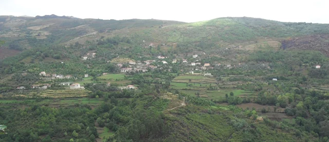
Panoramic view of Vilela, Rio Douro, with houses and agricultural plots on the slopes.
Vilela · architecture and landscape of Rio Douro© Ambcruzⓘ

In Vilela, the walls help to recognize the landscape.

Includes an activity to try →
Read here and view sources

The municipal presentation of the Cavez stream trail highlights the granite masonry in the old streets of Vilela, in Rio Douro. After the levadas and the lameiros, the reading of the territory continues in the houses: the material of the region also participates in the form of the settlement.

The municipal text presents a sequence that unites buildings and agricultural work: levadas, mills and lameiros de regádio precede the description of the streets of the village. Vernacular architecture is here the construction linked to the materials and practices of the place. The granite does not appear only as rock of the landscape; it enters the walls and the visual organization of the settlement.

To explore this relationship, it compares Vilela's photograph with reading on granite grains. A view of the village shows volumes and surfaces; a close look at the rock shows another scale. The municipal description does not date each house nor allows to conclude that all the walls have the same history.

Words in this story: see explanations →Getting to know the parish See Fact sheet: Vilela, Rio Douro See Fact sheet: Trilho da Ribeira de Cavez
Source and context

Municipality — stream of Cavez and agricultural landscape

Accessed: . Editorial summary; the date of consultation is not the date of the facts.

Cavez · rural economy in 1758

The mountains also gave coal

In Cavez, the memory of 1758 connects forests to fuel.

Includes an activity to try →Explore: The landscape had several jobs →
Read here and view sources

The parish priest of Cavez refers to carqueja, heather and other wood in the mountains and marks the abundant production of coal. In the same portrait, he describes corn, rye and green wine, of which was made brandy. Fields and woods entered into different works and products.

The memory allows to link vegetation to an economic activity, but does not explain how coal trees were built, where they stayed or who worked there. It also does not allow to calculate production. Separate what the text tells of these open questions makes the portrait more faithful: abundance is the appreciation of the author of 1758.

Getting to know the parish
Source and context

Municipality of Cabeceiras de Basto — Parish memories of 1758: Cavez

Accessed: . Editorial summary; the date of consultation is not the date of the facts.

Rural heritage · survey of 2008

Two puddles, shared water

In Beyond Rio, the water also tells a neighborhood story.

Includes an activity to try →
Read here and view sources

The survey of 2008 describes two pools side by side in Levada do Recoucão, in Bucos. The Puddles of Vilela allowed serving two consorts at the same time. They also received water from Veiga, shared by the entire population. The register helps to understand how the space was organized to share a common resource.

The document adds a change with the seasons: in winter there were two consorts; in summer, many. The levada also fed four mills. Thus, the same infrastructure articulated storage, sharing and work throughout the year.

Source and context

Municipality — inventory of levadas, fiche L8, Recoucão (28/01/2008)

Accessed: . Editorial summary; the date of consultation is not the date of the facts.

Rural heritage · survey of 2008

One water, several jobs

In Eiró, the work of the mill was linked to the irrigation of the fields.

Read here and view sources

The inventory of February 7, 2008 describes the Lagar da Casa da Portelada, in Eiró, Rio Douro, associated with a mill in the same building, with independent entrance. The water of the Levada de Millos served the equipment before going to the irrigation. This successive use connected food processing and agriculture. Private property registration does not confirm current visiting conditions.

The chart situates the old work of the mill in January and February. It also describes the arrival of water on the west side, through a granite structure, and distinguishes the entrance of the mill, to the north, from the entrance of the mill, to the south. They are clues to read the organization of the building. The document contains contradictory indications about the preserved parts; therefore, it does not allow to state that the set was complete or operational.

Source and context

Municipality — Lagares inventory, LA20 fiche, Portelada House (07/02/2008)

Accessed: . Editorial summary; the date of consultation is not the date of the facts.

Time travel

Documents, details and traditions: there is more to discover than a date on a stone.

Choose a story · 4
Abadim · history of grinding

The flour also yielded to the king

Granite mill served by Levada de Víbora, in all Moinhos de Rei, with waterfall and canal in the wooded surroundings. Register 2025.
Moinhos de Rei · the place of grinding© Joseolgonⓘ

Moinhos de Rei keeps a history of water, cereal and income.

Read here and view sources

In the historical narrative published by the Municipality, these community mills belonged to the Crown and half of the income was destined to the King. The same description refers to the later passage to a symbolic tax. The name of the place thus opens a window on the economic organization of the milling.

The income mentioned concerns the economic activity of the mill. It should not be converted, without further information, into a rule according to which each person delivers half of the cereal bag to the king. The presentation does not indicate accounts, milled quantities or the date of transition to symbolic tax.

When visiting the history of the Moinhos de Rei, you can ask two different questions: how did water reach the mill and how were the benefits of grinding distributed? The lead helps to follow the first; the reference to the Crown opens the second. Technique, organization and income are part of the same work landscape.

See Fact sheet: Moinhos de Rei
Source and context

Municipality — Moinhos de Rei, historical account of milling and the Crown

Accessed: . Editorial summary; the date of consultation is not the date of the facts.

Vila Nune · historical look to the margin of Atei

The work was on the other side

A memory of Vila Nune also looks at Atei.

Includes an activity to try →
Read here and view sources

In describing the Tâmega in 1758, the vicar refers mills that worked in the summer, in front of the parish, in the limits of São Pedro de Atei. He also recalls traces of attempts to build levadas and dams in the neighborhoods.

The reference shows how the report crosses the river. The mentioned mills are on the bank of Atei: this reading does not transform them into patrimony located in Cabeceiras or confirms traces visitable today.

Source and context

Municipality — Parish Memoirs of Vila Nune, 23/05/1758

Accessed: . Editorial summary; the date of consultation is not the date of the facts.

Bucos · transport in 1758

A small bridge, a long way

Married was in the way of a lot of people.

Includes an activity to try →Explore: Paths that served the life of the village →
Read here and view sources

In Casares, a wooden bridge integrated the real road to Braga and communications with Trás-os-Montes, according to the memory of 1758. Before the movement, the vicar defended building it in stone. It was a request, not the confirmation of a work.

The source distinguishes this passage from small walkways made with a wooden beam, for pedestrians. Different paths responded to different uses.

The passage not only served the village. The vicar describes a public road and very frequented, linking Braga to the term of Basto and Trás-os-Montes. The bridge emerges, as a local point of a larger network. The recommendation to replace it by chanting shows the author to assess a need, besides inventing what existed.

In the same rivers, the water moved mills and was used by farmers in the fields. The crossing, grinding and watering appear in the same portrait of the territory. A bridge can be read by what it allows to do: reach another place, maintain a communication or approximate works separated by water.

Words in this story: see explanations →Getting to know the parish
Source and context

Municipality — Parish memories of Bucos (1758)

Accessed: . Editorial summary; the date of consultation is not the date of the facts.

Cavez · Parish memories of 1758

A bridge that deserved praise

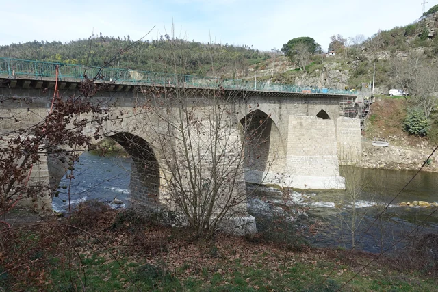
Ponte de Cavez on the river Tâmega, with stone arches, board and wooded banks.
Ponte de Cavez · crossing Tâmega© Joseolgonⓘ

In 1758, the Cavez Grand Bridge impressed the parish priest.

Explore: Two shores, several stories →
Read here and view sources

In the parochial memory, the crossing of the Tâmega appears described as a great stone bridge, well worked. The author even considers it the best of that river. The praise belongs to the look of those who wrote: it reveals the importance it attributed to the construction, without functioning as a technical comparison between bridges.

In the same memory, the Tâmega appears as a strong current, especially in winter. The document distinguishes the crossing from the use of water: it describes mills and explains that the river was too deep to water the fields in that stretch. The bridge can be read in this set of relations between margins, displacements and work.

Notice the difference between observing a construction and evaluating it. The existence of the bridge is information; considering it the best is an appreciation. The two say something about the past, but answer different questions.

Getting to know the parish See Fact sheet: Ponte de Cavez
Source and context

Municipality of Cabeceiras de Basto — Parish memories of 1758: Cavez

Accessed: . Editorial summary; the date of consultation is not the date of the facts.

The flavours of Cabeceiras

From the garden to the pot, from the oven to the table.

Choose a story · 6
Cabeceiras and neighboring municipalities · food memory

Maize with rice size

The millers tell a rural table story.

Includes an activity to try →Explore: A cereal, different transformations →View ingredients and preparation →
Read here and view sources

The Museum describes the millers as crushed corn in the mill until it is in small grains. In daily feeding, beans, sprouts of cabbage or codbones could be added for flavor. Pigmeat appeared on holiday or in the most resourceful houses. Hence the distinction between rich and poor millions. The publication of 2019 places this tradition in Cabeceiras and neighboring municipalities.

In the recipe of rich millers presented by the Museum, intercost, bat, sausage and sausage accompany the cereal. The difference between versions also helps to read the living conditions and occasions of consumption. The same ingredient could sustain a simple meal or integrate a more abundant table.

Words in this story: see explanations →
Source and context

Land Museum of Basto — Millions (2019)

Accessed: . Editorial summary; the date of consultation is not the date of the facts.

Abadim · bread heritage

Before the bread, there was a field

At Casa do Pão, cereal is the beginning of the story.

Includes an activity to try →Explore: From field to next batch →
Read here and view sources

The bread comes to the table after a lot of work. At Casa do Pão, in Moinhos de Rei, Abadim, agricultural utensils and tailors help to reconstitute the bread cycle and the production of corn and rye. The municipal presentation connects the objects to baking and bread-proof. It is an entrance to understand the path between field, processing of the cereal and oven. Consult the contacts and the conditions of visit in the form before planning a demonstration.

Words in this story: see explanations →Getting to know the parish See Fact sheet: Casa do Pão
Source and context

Visit Cabeceiras — Casa do Pão, Moinhos de Rei

Accessed: . Editorial summary; the date of consultation is not the date of the facts.

Bucos · testimony of 1758

Three cereals in the same landscape

The storeroom of Bucos did not depend on one grain.

Includes an activity to try →Explore: From grain to mill →
Read here and view sources

The parish priest of 1758 lists target corn, million and rye, saying that they were produced in similar proportions. He also mentions some wine and little chestnut. It is the agricultural portrait he left in writing, not a description of the current crops.

And where were the grains transformed? In the same memory, António Alves Teixeira describes mills in the two water courses of the parish and farmers that carried the cereal there. The document allows to link the list of crops to the milling, although not detail recipes nor the division of each cereal between food and other uses. The date, 22 May 1758, marks the moment of the report: the proportions mentioned are an appreciation of the vicar, not a weighing of a harvest.

Getting to know the parish
Source and context

Municipality — Parish memories of Bucos (1758)

Accessed: . Editorial summary; the date of consultation is not the date of the facts.

Saint Nicholas · agriculture described in 1758

Not all the cereal was the same

Rye, target corn and million appear side by side in the old account.

Includes an activity to try →Explore: What held the table? →
Read here and view sources

In 1758, the parish priest of São Nicolau distinguishes rye, target corn and million among the crops. He adds wine, olive oil, chestnuts and other fruits, describing a production to support the growers. In speaking of the fields on the hills, he highlights mainly rye. The variety of words invites to read the agriculture of the past without reducing all the cereals to a single crop.

The report places the fields in the low areas, among mountains that separated the places. The water entered this organization: mentions mills, dams and levadas that served fields and farms. Cultivating was not only choosing a seed; it also depended on the land and access to water.

For the animals of labor, the farmers turned to the hills for part of the year, for lack of pasture in the fields, collecting them at night. Read together, these passages show fields, mountains, animals and water as parts of the same rural life. They are observations of the parish priest in 1758, not quantities of production or current agricultural rules.

Source and context

Basto Land Museum — St Nicholas Parish Memories (1758)

Accessed: . Editorial summary; the date of consultation is not the date of the facts.

Alvite · mill inventory in 2008

From Petimão to olive oil mill

One carried energy to Ramil's house.

Read here and view sources

The municipal survey of 2 of March 2008 describes the mill of Casa do Ramil, in Alvite, fed by Levada do Vale do Moinho, with water removed from the riverside of Petimão. A granite cube led the water to the rotation. The building had two presses and the inventory recorded the deactivation in 2005. This portrait documents the connection between water, construction and transformation of the olive. It is a private property: the historical survey does not confirm public access nor the current state of the equipment.

Compare Covas, in Peio: then the inventory describes a wooden gutter. In both cases, it is important to follow the link between the levada and the mechanism, without imagining that all mills used the same solution.

Source and context

Municipality — inventory of olive oil mills, record L.A.1, withdrawal of 02/03/2008

Accessed: . Editorial summary; the date of consultation is not the date of the facts.

Refojos · kitchen memory collected by the Museum

A recipe learned at parties

Shroud popes also tell how knowledge circulates.

Includes an activity to try →Explore: The word popes holds differences →View ingredients and preparation →
Read here and view sources

Maria Helena da Mota Lopes da Silva Almeida, resident in Refojos since childhood, told that she had learned these popes in the early 21st century. The master was a cook from Porto who came to Cabeceiras to work in baptisms and marriages. The parties were also places where techniques and recipes were learned.

The version collected in June 2011 combines different meats, cornmeal, cooked pig blood, red wine and cumin. The report situates the preparation in winter until the end of March. The publication, July of that year, documents the transmission of a knowledge and its usual time; it does not indicate a menu available today.

Source and context

Basto Land Museum — A recipe learned at parties, publication of 06/07/2011

Accessed: . Editorial summary; the date of consultation is not the date of the facts.

YOUR LOCAL GUIDE

What would you like to discover?

Take a closer look.