Discover Cabeceiras de BastoFree independent guide
ViveCabeceirasYOUR GUIDE TO CABECEIRAS
ENEnglish
SearchSaved

Stories of Cabeceiras

Choose a story to start with. You can change the subject or fine tune the search.

37 stories · All themes · Search: igreja

Time travel

Documents, details and traditions: there is more to discover than a date on a stone.

Choose a story · 25
Holy Lady · memory of 1758

A Church Counted in Images

Before the screens, you looked at the panels.

Includes an activity to try →
Read here and view sources

In the memory of 1758, the church of Santa Senhorinha had two ships with programs of different images. One presented panels on the Creation of the World; the third Franciscan showed saints of this order.

The abbot also described a vaulted chapel, closed with iron railings. Painting, spaces and architectural elements composed a written portrait of the interior. The source allows to study this description, without ensuring that the pieces or layout are preserved today.

The description continues by the tombs, which the Abbot presents decorated with painting and golden letters, and by a particular chapel dedicated to Our Lady of the Pilar. The interior appears as a set of spaces, images and inscriptions, each with its function in the account.

This allows a layer reading: first the organization of the ships, then the painted themes and, finally, the elements that marked memory and devotion. It is not necessary to imagine a single undifferentiated hall; the document itself distinguishes various environments.

Words in this story: see explanations →See Fact sheet: Igreja de Santa Senhorinha
Source and context

Municipality — Memória de Santa Senhorinha, 23/05/1758; transcript of José Viriato Chapel (2003)

Accessed: . Editorial summary; the date of consultation is not the date of the facts.
Faia · memory 1758

Five altars to read a church

Devotions also organized space.

Read here and view sources

The Abbot of Faia recorded five altars in 1758, mentioning the Name of God, Saint Anthony and Our Lady, with the invocation of the Rosary and its brotherhood. The document shows different devotions gathered in the same church.

The restoration reported in 2022 belongs to another time. The two descriptions have different objectives and times: it is not enough to compare numbers to determine which pieces remained or disappeared. The church record allows to continue the discovery of the building, keeping separate historical memory and visit information.

The enumeration distinguishes the larger altar from the four collaterals. The reference to the brotherhood of the Rosary adds people to space: the church appears not only as a set of pieces, but also linked to a devotional organization. However, the text does not describe the composition of this brotherhood or its activities in detail.

See Fact sheet: Igreja de São Tiago da Faia
Source and context

Municipality — Memory of Faia, 23/05/1758; transcript of José Viriato Chapel (2003)

Archdiocese of Braga — restoration and reopening of the matrix of Faia, 01/09/2022

Accessed: . Editorial summary; the date of consultation is not the date of the facts.

Faia · religious organization in 1758

A church linked to the Grand Prior of Crato

The history of a parish also goes through distant connections.

Read here and view sources

In the reply of 1758, the abbot of the Faia writes that his presentation belonged to the infant D. Pedro, as Grand Prior of Crato. He also refers to the intervention of the provisor of the city of Porto in its collation. These details show that the local religious organization involved authorities beyond Cabeceiras. The account describes the form of provision of the office at that time; it does not mean that the Faia belonged to the municipality of Crato or Porto.

The same answer estimated the income of the benefit in 450 réis. This value belongs to the description of the institution and should not be presented as a current salary or converted directly into a price today. Dealing with the altars and chapels, adds a layer to the history: besides the building and the devotions, there was an organization of positions and incomes.

Getting to know the parish
Source and context

Municipality of Cabeceiras de Basto — Parish memories of Faia, 23/05/1758, replies 8, 20 and 21

Accessed: . Editorial summary; the date of consultation is not the date of the facts.

Bucos · assets described in 1758

Gold and red in church

The document also kept the colors.

Includes an activity to try →
Read here and view sources

In the church of St John of Bucos described in 1758, the main altar combined golden reliefs and vermilion backgrounds. The account places St John the Baptist and St Dominic on opposite sides and the sacrary in the center of the altarpiece. He also mentions altars with Our Lady of the Rosary, Saints Pedro and Saint Anthony. This written portrait allows you to imagine the organization and colors of the ancient interior, without confirming that the pieces or disposition are preserved today.

Words in this story: see explanations →See Fact sheet: Igreja de São João de Bucos
Source and context

Municipality — Parish memories of Bucos (1758)

Accessed: . Editorial summary; the date of consultation is not the date of the facts.

Faia · restoration documented in 2022

A year of works, a church reopened

The heritage is also a recent care.

Explore: The church at different times →
Read here and view sources

The church of São Tiago of Faia reopened in 14 August 2022, after about a year closed for works. The news of the Archdiocese of Braga records the recovery of paintings, images and three altars, besides the placement of stained glass with episodes of the life and mission of the patron. It is a recent intervention, different from the portrait of five altars left in 1758: they are sources of distinct times, not a directly comparable count of surviving pieces.

The news also tells who made the intervention possible. Pastor Rui Filipe Marques Araújo attributed the realization of the works to the involvement of the community; the ceremony brought together associative representatives, workers and benefactors. Archbishop José Cordeiro presided. Behind the paintings and the recovered or placed stained glass is thus a history of participation.

Reopening does not necessarily mean that all works were completed: the same news records an appeal to continue the completion of the restoration. The August date marks the celebration and return of space to religious use, without allowing the end of each intervention to be established.

See Fact sheet: Igreja de São Tiago da Faia
Source and context

Archdiocese of Braga — restoration and reopening of the matrix of Faia, 01/09/2022

Accessed: . Editorial summary; the date of consultation is not the date of the facts.

Alvite · church described in 1758

Three altars in one body

The church also fits in a portrait made of words.

Includes an activity to try →Explore: From church to places of worship →
Read here and view sources

In 1758, the vicar described the church of Alvite with three altars: the principal, associated with St Pedro, and those of the Name of God and the Lady of the Rosary. He referred to a single body, choir, main chapel and sacristy. It is the provision registered at that time, without confirmation that it remains the same.

The document situates the church in Cacheina, surrounded by residents. It distinguishes the main altar of the two collaterals and mentions a brotherhood associated with the brotherhood of the Blessed Sacrament. The portrait of the building thus includes a community: places of worship, people and religious organization appear in the same response.

A list of spaces is not enough to reconstruct a plant. We can recognize functions and names, but the exact position of each dependency would require other sources. It is a good occasion to compare what a text describes with what an external photograph can show.

Words in this story: see explanations →
Source and context

Municipality — Alvite Parish Memories, 1758; transcription of José Viriato Chapel (2003)

Accessed: . Editorial summary; the date of consultation is not the date of the facts.
Saint Nicholas · interior described in 1758

Five altars, many stories

The memory of 1758 lets you look inside the church.

Includes an activity to try →
Read here and view sources

The Rector Domingos Camel de Sousa described five altars in the church of St. Nicholas. On the main altar, he placed St. Nicholas and St. Brás on opposite sides and Christ Crucified to the center, in a golden tribune.

The remaining altars were dedicated to the Lady of the Rosary, to the Lord of the Passos, to Saint Sebastian and to the Souls of Purgatory. It is a portrait written in 1758, not a confirmation of the current disposition.

See Fact sheet: Igreja de São Nicolau de Cabeceiras
Source and context

Basto Land Museum — St Nicholas Parish Memories (1758)

Accessed: . Editorial summary; the date of consultation is not the date of the facts.

Bucos · testimony of 1758

A chapel shortened the distance

In Casares, getting to church was a practical matter.

Includes an activity to try →
Read here and view sources

In the memory of 22 May 1758, the chapel of Santa Maria, in Casares, served to administer the sacraments to the residents, far from the parish church. The distance helped explain the distribution of places of worship.

The vicar António Alves Teixeira also mentions Santa Ana, in Carrazedo, administered by Manuel Gomes Martins. They are references of the document, without confirmation of access or current status.

The parish church was located in the place of Bucos, which the vicar presented as the most populous of the parish. In addition, he named Vila Boa, Carrazedo and Casares. This set of places helps to understand why a single church did not respond in the same way to the needs of all residents.

The document also distinguishes who administered each chapel: in Casares, the commander; in Carrazedo, Father Manuel Gomes Martins. Place, invocation and administration are three different clues. The function of administering sacraments because of the distance is explained to Casares; it should not be automatically attributed to all the chapels mentioned.

Getting to know the parish
Source and context

Municipality — Parish memories of Bucos (1758)

Accessed: . Editorial summary; the date of consultation is not the date of the facts.

Saint Nicholas · testimony of 1758

When the chapel shortened the path

The distance from the church also shaped the villages.

Includes an activity to try →Explore: Three Ways to Approach Places →
Read here and view sources

The memory of 1758 explains the function of three chapels: Saint Bartholomew, in Celeiró do Monte; Our Lady of Lapa, in Lapela; and Saint Anne, in Busteliberne. They served to administer sacraments to the residents who lived far from the matrix. A small building responded to a daily difficulty.

The dean Domingos Camel de Sousa describes high hills between the places and refers three settlements away half league from the church, in rough terrain. The distance was not only a line on the map: relief was part of the difficulty. The church was to spring, in a place with six neighbors, counting the house of the rector himself.

The three chapels were kept at the expense of the commendator, according to the report. But they were not the only ones: the text lists eleven chapels beyond the matrix, with different administrations and functions. In the Outeiro of Santo António, for example, it marks pilgrimages of neighboring parishes in the feasts of Santo António and Santa Luzia. The set reveals both the cult close to the residents and meetings that attracted people from outside.

Words in this story: see explanations →Getting to know the parish See Fact sheet: Busteliberne See Fact sheet: Igreja de São Nicolau de Cabeceiras
Source and context

Basto Land Museum — St Nicholas Parish Memories (1758)

Accessed: . Editorial summary; the date of consultation is not the date of the facts.

Pedraça · housing

Pedraça is also counted by houses

Beyond the church, there is a housing landscape.

Includes an activity to try →Explore: Houses, persons and work in Pedraça →
Read here and view sources

The history of Pedraça is also read in the houses. The municipal presentation highlights Casa do Paço, Casa de Parada and the houses of the Baron of Basto and Paço de Vila. For Parada, it uses the expression Brazilian taste; for Casa do Paço, it draws attention to the name of the place. They are different clues: one points to architecture, another to the toponymy.

These houses are part of a parish that the Municipality describes as fertile and abundant in water, linked to agriculture and the cultivation of flax. Approaching the housing of the work landscape helps to look at the heritage beyond religious buildings.

The municipal description does not provide construction dates for this set nor identifies those responsible for each work. Nor does the reference to Brazilian taste enough to reconstruct the biography of a owner. The houses are here starting points to know the parish; their inclusion does not presuppose public access.

Words in this story: see explanations →
Source and context

Municipality — parish presentation of Pedraça

Accessed: . Editorial summary; the date of consultation is not the date of the facts.

Rio Douro · places and hermits described in 1758

Fifteen places, a network of chapels

The distance from the church also shaped the lives of the villages.

Includes an activity to try →
Read here and view sources

In the memory of Rio Douro of 1758, the vicar lists fifteen places and places the church outside the village. He also refers to fifteen hermits, explaining their relationship with religious assistance to people living far from the home.

St. Stephen stayed outside Eiró; other invocations accompanied names of villages, such as Santa Ana in Toninha, São Gonçalo in Vilela and São Frutuoso in Leiradas. The document also distinguishes religious responsibilities from Refojos, private and residents. It is a historical network of places, devotions and care, without confirming the conservation or current access to each building.

Source and context

Municipality — Parish Memoirs of Rio Douro, António Carneiro da Costa, 22/05/1758

Accessed: . Editorial summary; the date of consultation is not the date of the facts.

Refojos · art and architecture

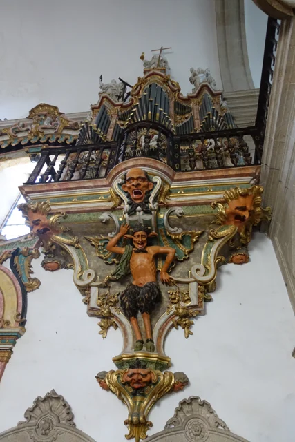
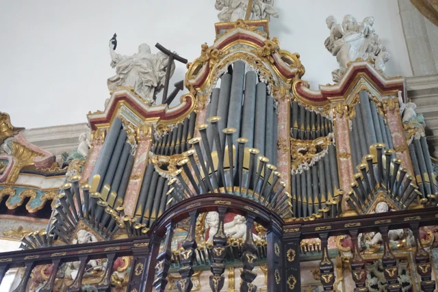
Two organs, one of them mute

Organ with tubes and golden cut, on carved figures and decorative faces.
View of the organ and the decoration that sustains it, photographed in 2016. The image does not determine which of the two organs is the mute.
Photography: Joseolgon · CC BY-SA 4.0
About this photograph

Date given at source: . Source consulted in 2026-11-07. EXIF orientation, proportional resizing and WebP conversion; no retouching or clipping of the file.

Request removal or correct the photo credit

See more 2 photos and details
Organ tubes at different heights, surrounded by golden cut and light sculptures.
Details of the tubes, cut and sculptures of the organ in 2016.
Photography: Joseolgon · CC BY-SA 4.0
About this photograph

Date given at source: . Source consulted in 2026-11-07. EXIF orientation, proportional resizing and WebP conversion; no retouching or clipping of the file.

Request removal or correct the photo credit

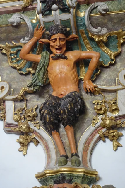
A figure carved with horns, pointed ears and fur-covered legs between golden elements.
Details of a figure carved under the organ in 2016.
Photography: Joseolgon · CC BY-SA 4.0
About this photograph

Date given at source: . Source consulted in 2026-11-07. EXIF orientation, proportional resizing and WebP conversion; no retouching or clipping of the file.

Request removal or correct the photo credit

An invitation to look beyond the facade.

Includes an activity to try →Explore: The pulpits had more than one step. →
Read here and view sources

The municipal description identifies two lateral organs, being a mute. The visual symmetry of the church does not correspond, therefore, to two sound instruments. Next to the entrance appear frowns; later, the wood creates another surprise effect.

The two pulpits are painted brown to imitate marble and partially golden. The fountain places the execution in 1777–1780 and the painting and browning in 1786–1789. Shape, material and finishing count different stages of the same work. This patrimonial description does not confirm the current functioning of the organ.

The choir adds another reading of the wood: the Municipality describes a brown chair, of 1767–1770, organized in two levels and in the shape of U. São 45 seats, with the place of the abbot to the center. The disposition helps imagine a community gathered, instead of looking at each chair separately.

At the top, the circular zimbarium is accompanied by interior and exterior balconies. The description identifies the twelve apostles and, on the top, St. Michael. From furniture to silhouette, they change the scale and the observation point. The photographs of this reading show details of the organ; they do not document all these elements.

Words in this story: see explanations →See Fact sheet: Mosteiro de São Miguel de Refojos
Source and context

Municipality — history and art of Mosteiro de São Miguel de Refojos

Accessed: . Editorial summary; the date of consultation is not the date of the facts.

Bucos · transport in 1758

A small bridge, a long way

Married was in the way of a lot of people.

Includes an activity to try →Explore: Paths that served the life of the village →
Read here and view sources

In Casares, a wooden bridge integrated the real road to Braga and communications with Trás-os-Montes, according to the memory of 1758. Before the movement, the vicar defended building it in stone. It was a request, not the confirmation of a work.

The source distinguishes this passage from small walkways made with a wooden beam, for pedestrians. Different paths responded to different uses.

The passage not only served the village. The vicar describes a public road and very frequented, linking Braga to the term of Basto and Trás-os-Montes. The bridge emerges, as a local point of a larger network. The recommendation to replace it by chanting shows the author to assess a need, besides inventing what existed.

In the same rivers, the water moved mills and was used by farmers in the fields. The crossing, grinding and watering appear in the same portrait of the territory. A bridge can be read by what it allows to do: reach another place, maintain a communication or approximate works separated by water.

Words in this story: see explanations →Getting to know the parish
Source and context

Municipality — Parish memories of Bucos (1758)

Accessed: . Editorial summary; the date of consultation is not the date of the facts.

Saint Lady · celebrations at 1758

When the parishes met

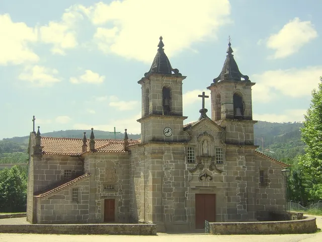
Facade of Igreja de Santa Senhorinha of Basto, with its two towers
Igreja de Santa Senhorinha · heritage context of the parish, not a record of the 1758 celebration© Bocacheteⓘ

A celebration also gathered the territory.

Explore: What made a community meet? →
Read here and view sources

In 1758, the procession of the Body of God gathered in Santa Senhorinha the Chamber and representatives of the nearby parishes, with crosses and ecclesiastics. The memory mentions expenses with wax and sermon: behind the celebration there was preparation, objects and work.

The Abbot also describes separately the triduum of the forty hours, with music and sermons for three days. Distinguishing the two references helps to realize the religious calendar of that time. The document is a testimony of 1758, not the agenda of the current feasts.

Words in this story: see explanations →Getting to know the parish
Source and context

Municipality — Parish Memoirs of Santa Senhorinha (1758)

Accessed: . Editorial summary; the date of consultation is not the date of the facts.

Painzela · reading a 1758 document

How did you count a parish?

In 1758, the portrait of Painzela used fireworks and sacramental souls.

Includes an activity to try →Explore: A document opens other questions →
Read here and view sources

The municipal transcription of the Parish Memories records 137 fires and 439 sacramental souls in Painzela. The formulation itself distinguishes domestic units from a religious category of people. Therefore, the 439 should not be presented as a modern census of all inhabitants. The document also allows to know the language used to describe the community.

The same passage identifies Saint Andrew as a dedication of the matrix and connects the presentation of the vicar to the abbot of Santa Senhorinha. The small text therefore gathers population, church and ecclesiastical organization. Instead of reading it as a statistical table, we can ask what the author chose to record about the community.

There is also a layer between the old document and the screen: the municipality informs that the transcript updates the spelling and the score from the edition of José Viriato Chapel, published in 2003. This indication helps to distinguish the date of the testimony, 1758, from the date of the edition used to disseminate it. The references to the chapels appear separately, in the documentary note.

Getting to know the parish
Source and context

Municipality — Parish memories of Painzela (1758)

Accessed: . Editorial summary; the date of consultation is not the date of the facts.

Holy Lady · memory of 1758

Not all bridges were stone

The wood also united the banks.

Read here and view sources

The memory of 1758 lists three wooden bridges in the parish: Vagalhafos, in Quinta de Vila de Lobos; Santa Senhorinha, near the church; and Olela. Names approach the crossings of the farms, the place of worship and the inhabited places.

The same report mentions singing bridges in São Clemente and São Martinho do Arco de Baúlhe. Wood and stone appear, thus, in a single description of the river. The enumeration does not provide construction dates nor proves the survival of structures.

Words in this story: see explanations →
Source and context

Municipality — Memória de Santa Senhorinha, 23/05/1758; transcript of José Viriato Chapel (2003)

Accessed: . Editorial summary; the date of consultation is not the date of the facts.
Heritage of Outeiro · account published in 2012

A Medieval Image Found On Earth

Wood can keep centuries of memory.

Includes an activity to try →Explore: Three moments, different dates →
Read here and view sources

A municipal report of 2012 highlights a sculpture of Santa Maria belonging to the church of Outeiro, dating from the 13th or 14th century. The Virgin appears crowned, seated on a throne, with the Child on his knees. The account says that the play was found buried in the place known as Mata da Santa and taken by parishioners to church. The news doesn't date the discovery. This story allows to know the path of the image, without confirming where it is currently exposed.

Words in this story: see explanations →See Fact sheet: Igreja de Santa Maria Maior de Outeiro
Source and context

Municipality — Parish of Outeiro exposes acquis No Núcleo de Arte Sacra, 09/10/2012

Accessed: . Editorial summary; the date of consultation is not the date of the facts.

Faia · settlement described in 1758

A parish told by sixteen places

In 1758, the Faia appears as a network of small places.

Includes an activity to try →Explore: A parish distributed by places →
Read here and view sources

In memory of 23 May 1758, the abbot João de Lima Lobo de Noronha enumerates sixteen places. The enumeration includes Covilhã, Augueiros, Presas, Nogueira, Candedo, Ribeiro, Outeiro, Porcarice, Faia, Togais, Souto, Ribeira, Tuesdays, Breia, Casa Nova and Joio. Situa the church out of place and describes the parish on a northern slope.

The list helps to think of a territory distributed by small cores, and not just around the matrix. Names belong to historical transcription; they are not a current administrative list or allow to draw the boundaries of each place by themselves.

The same testimony presents two counts: 99 neighbors and 418 people. The document separates them; they should not add or read “neighbours” as another total of inhabitants. It also distinguishes scales: when speaking of the municipality, the abbot refers to eighteen parishes, but declares not knowing the number of its neighbors. Knowing what the author did not tell is as useful as knowing the numbers he left.

Ribeiro and Ribeira appear as different entries. Outeiro is here in the list of places of Faia: the coincidence with the name of another parish does not authorize to shift this reference on the map. The complete list allows to compare names, while chapels help to perceive some relations between places and houses.

Source and context

Municipality — Memory of Faia, 23/05/1758; transcript of José Viriato Chapel (2003)

Accessed: . Editorial summary; the date of consultation is not the date of the facts.
Refojos · 19th and 20th century transformations

After the monks, other lives

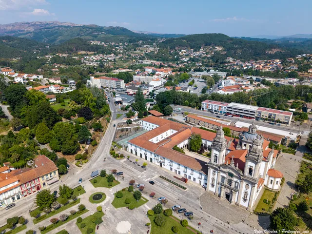
Air view of the Monastery of São Miguel and the Republic Square in Refojos
Current view of the Monastery of Refojos and the square; it is not an image of the nineteenth-century uses.© Vitor Oliveira from Torres Vedras, PORTUGALⓘ

Camera and school are also part of the history of the building.

Explore: The building changed its life by stages →
Read here and view sources

The extinction of religious orders, in 1834, changed the fate of the set of Refojos, keeping the church in the religious function. According to the municipal proposal of patrimonial candidacy, João António Fernandes Basto acquired the Monastery in public haste between 1838 and 1842. In the nineteenth century, the assembly also welcomed municipal services; in 1944, another part received a college with boarding school. Looking at the whole is also to discover how ancient buildings were adapted to administration and teaching.

The document places around 1855 the installation of the city services in the part of the cloisters. For the school area, it registers a new change of ownership in 1959, for the Conciliar Seminary of Braga. The group therefore did not have a single destination after 1834: different parts followed their own stories. The heritage proposal is here a historical source; it does not demonstrate a UNESCO classification nor confirms the current uses of each space.

Words in this story: see explanations →See Fact sheet: Mosteiro de São Miguel de Refojos
Source and context

Municipality — proposal for a heritage registration of the Monastery, pp. 9 and 11; later uses in p. 11 (candidature document, not a UNESCO classification)

Basto Land Museum — The place of the Pereiras of Refojos de Basto, 28/07/2024

Accessed: . Editorial summary; the date of consultation is not the date of the facts.

Holy Lady · transmission of religious accounts

A story that came in copies

The texts also have their own time travel.

Explore: Three ways to get to know Saint Lady →
Read here and view sources

Odília Alves Gameiro studies three texts on the life and miracles of Santa Senhorinha, preserved in copies of the 16th century: two in Latin and one in Portuguese. The similarities between them suggest, according to the researcher, a medieval original. Reading these versions allows you to study the construction of memory and worship. The time of a copy is not necessarily the time of the story that tells.

The two Latin testimonies studied come from Coimbra: one from the College of Grace and another from Santa Cruz. This provenance helps to realize that the memory of a saint linked to Basto circulated beyond the place of worship. Each copy is also an object with a history of conservation and transmission.

There are three times to be separated: that of the life narrated, that of the composition of the account and that of the copy that came to us. The investigation situates Little Lady in the second half of the 10th century, but does not transform the five hundredth-century texts into testimonies written by those who knew her. The similarities and differences between versions are precisely part of the historical work.

The study also reads the reports in the context of a rural community: crops, food and trips appear among the concerns represented. Hagiography allows to know this imaginary and the values that the text seeks to transmit, besides counting wonders.

Words in this story: see explanations →
Source and context

Odília Alves Gameiro — The nobiliarchic appropriation of a rural cult: the hagiography of Santa Senhorinha of Basto, Archipelago · History, 2001, pp. 561–562 and 571–572

Accessed: . Editorial summary; the date of consultation is not the date of the facts.

Holy Lady · church and manor houses

A “Sé” and houses with memory

Facade of Igreja de Santa Senhorinha of Basto, with its two towers
Igreja de Santa Senhorinha, popularly known as the Sé of Basto.© Bocacheteⓘ

The names also express the importance of a place.

Read here and view sources

The municipal presentation records the popular designation Sé of Basto for the church of Santa Senhorinha, associating it with the idea of antiquity. In the manor houses, it highlights buildings from the 17th and 18th centuries, some with coats and chapels. Paço, Castelo, Mozes and Vila Garcia were already mentioned in 1726. This reference helps to read the heritage of the parish, without assuming that the houses are visitable or that all the old elements are preserved today.

The municipal portrait does not end in the four houses mentioned in 1726. It includes Carcavelos, Cainhos, Casa do Oven, Eirões and Olela, extending the look to several places. In religious architecture, mentions the chapel of Calvary, also called Senhora do Ó, in Olela, and that of Santo António. They are references to know the diversity of the heritage, without assigning to all buildings the same date.

The Sé designation of Basto belongs to the popular use described by the Municipality. In this reading, it acts as a clue to the importance attributed to the church; it has not been converted into an affirmation of cathedral status. Compare this name with the memory of the painted panels allows you to look at the building through words of different times and purposes.

Words in this story: see explanations →See Fact sheet: Igreja de Santa Senhorinha See Fact sheet: Casa de Carcavelos See Fact sheet: Casa e Quinta do Forno See Fact sheet: Capela do Calvário / Senhora do Ó
Source and context

Municipality — Basto (Santa Senhorinha): designation of church and manor houses

Accessed: . Editorial summary; the date of consultation is not the date of the facts.

Santa Senhorinha · landscape described in 1758

A valley full of names

In 1758, the parish also counted for its seats.

Includes an activity to try →
Read here and view sources

The parish report places Santa Senhorinha in a valley between the Gatiras and the Ladario. It lists places such as Rendufe, Soutelo, Outeiro Seco, Olela, Devesa and Vila Garcia, among many others. The church is described outside the village, in the middle of a field. This portrait allows you to imagine a community distributed across several cores, but retains the names and perspective of the document of 1758, without functioning as a current map.

The author also lists villages that were seen, distinguishing the position in the valley of the look from the Ladário. Visibility was part of the way of presenting the territory. A place could be described by what surrounded it and by what could be seen from a higher point, beyond its limits and names.

Source and context

Municipality — Parish Memories of Santa Senhorinha (1758), replies 4 and 6; transcription of José Viriato Chapel (2003)

Accessed: . Editorial summary; the date of consultation is not the date of the facts.
Gondiães e Vilar de Cunhas · banknotes published on 1758

Two old portraits, two ways to count

A short note can also open a window to the story.

Includes an activity to try →
Read here and view sources

The municipal transcription of 1758 presents Gondiães with 55 fireworks and 269 souls of communion, together with the matrix dedicated to Saint Martin. Vilar mentions 41 neighbors and 141 sacramental souls, with the church dedicated to St. Lawrence. Both places are located at the end of Cabeceiras de Basto, in the district of Guimarães.

It is important to keep the words of the source: fires or neighbors and souls are not the same category. These numbers should not be added as if they all counted people, nor presented sacrament souls as a modern census of the total population. The text of Gondiães gives the information to Lima; the reference should accompany the reading of these numbers.

Source and context

Municipality — Parish Memoirs of Gondiães (1758), transcript published from José Viriato Chapel (2003)

Municipality — Parish Memoirs of Vilar de Cunhas (1758), reference to José Viriato Chapel (2003)

Accessed: . Editorial summary; the date of consultation is not the date of the facts.
Cavez · settlement and devotion in 1758

Eight places and six chapels

In Cavez, an ancient list draws relations between villages, residents and monasteries.

Includes an activity to try →
Read here and view sources

In 25 of May 1758, the vicar Manuel Pacheco da Cunha numbered eight places: Cavez, Vila Franca, Ponte, Arosa, Rabiçais, Moimenta, Revorça and Parada. He located the church in the middle of the parish and described six chapels. Names help to recognize a hammock; they are not a current list of administrative places.

São Gregório, in Vila Franca, São Mamede, in Arosa, and Santa Maria Magdalena, in Moimenta, were attributed to the abbot of Pombeiro, with its maintenance linked to the Benedictine congregation of Tibães. São Bartolomeu, on the Bridge, had as patron João Correia, of Guimarães. In São Caetano, in Raviceis at the passage of the chapels, and Santa Luzia, in Revorça, the charge was for the residents. The transcription itself uses the variants Rabiçais and Raviceais.

The report also describes five altars in the matrix and a brotherhood of the Souls. The parish appears as a space of worship and collective organization, with distinct responsibilities. The pilgrimage of São Bartolomeu is mentioned for 23 and 24 of August; they are dates of historical testimony, without functioning as current agenda.

The parish links went beyond the chapels. The vicar wrote that Cavez did not have their own mail and resorted to Raposeira, which was located to a league. He also indicated the absence of fair in the parish. They are clues to think where news arrived and where services were concentrated at that time; they do not describe the current offer nor allow automatically to convert the league into a road distance.

Getting to know the parish See Fact sheet: Capela de São Bartolomeu de Cavez See Fact sheet: Igreja de São João de Cavez e cruzeiro
Source and context

Municipality of Cabeceiras de Basto — Parish memories of 1758: Cavez

Accessed: . Editorial summary; the date of consultation is not the date of the facts.

Vila Nune · settlement described in 1758

A parish, many small places

Telling neighbors wasn't the same as counting people.

Includes an activity to try →Explore: Places, people and paths →
Read here and view sources

In May 1758, the vicar of Vila Nune registered 55 neighbors and 239 people. He numbered fourteen places, some with only one resident, and marked uninhabited houses in the place of Serra.

These numbers describe different categories of the document. They should not be added or confused with a current census. The small scale of the places helps imagine a scattered settlement, observed from the parish.

The enumeration allows to approach the look: Silva assigns eight neighbors; to Vale and Rossada, five to each. Fojães and Ribeira da Covilhã appear with one resident. The church was in Granja, near the Valley. The religious center was not confused, therefore, with the place called Vila Nune.

The vicar Domingos Leite de Andrade adds that there were unmarried women in poverty between neighbors and people from other parishes. It is the social description of an author and of a time, without allowing the life of each person to be reconstructed. By preserving the terms and date, the document allows different domestic conditions to be observed within the small places.

Source and context

Municipality — Parish Memoirs of Vila Nune, 23/05/1758

Accessed: . Editorial summary; the date of consultation is not the date of the facts.

Read the landscape through the plants

Trees, forests, vineyards and fields reveal different ways of occupying the territory.

Choose a story · 1
Refojos · monastic landscape

Beyond the church, cultivated land

Air view of the Monastery of São Miguel and the Republic Square in Refojos
View of the Monastery of Refojos and the urban surroundings. It is a context image, not a reconstruction of the cultivated fence.© Vitor Oliveira from Torres Vedras, PORTUGALⓘ

Vegetable gardens, orchards and medicinal plants formed part of the monastery grounds.

Includes an activity to try →Explore: The fence continues in other stories →
Read here and view sources

According to the municipal description of 2021, vegetable gardens, orchards, medicinal plants, fields and woods made up the former grounds of Refojos Monastery. Its pharmacy supplied other Benedictine monasteries, including Tibães. Beyond the church, there was land to cultivate and medicine to prepare. This is a historical portrait of the grounds, not an inventory of today’s plants.

The same description places the Penoutas stream beside and behind the monastery, near former agricultural buildings now adapted as museum spaces. Water and working buildings broaden the view: the story of the complex extends beyond worship.

The former grounds can no longer be read as one intact garden. The source draws attention to scattered traces. Distinguishing what the document describes from what a photograph shows is part of the discovery: a view of the square does not reconstruct vanished vegetable gardens, orchards or medicinal plants.

Words in this story: see explanations →Getting to know the parish See Fact sheet: Mosteiro de São Miguel de Refojos
Source and context

Municipality — historical gardens, news of 21/05/2021

Accessed: . Editorial summary; the date of consultation is not the date of the facts.

Crafts and memories

In the hands, at the table and in the community: little stories of how one lives and what one transmits.

Choose a story · 5
Outeiro and Refojos · 2012 initiative

When the images came out of the church

A work can also open a discovery.

Includes an activity to try →Explore: One play, several contexts →
Read here and view sources

A work in the church opened an opportunity to know its sculptures. In October 2012, the Municipality announced the deposit and temporary exhibition of twelve pieces of Outeiro in Núcleo de Arte Sacra, installed in the former sacristy of Refojos. They represented the Virgin and other saints, from medieval to twentieth century. The partnership between parish and municipality thus brought together objects from different times and a concrete need for conservation during the preparation of the works. The news documents that initiative, not a current exhibition.

The reason for the displacement was concrete: the church prepared remodeling and expansion works. According to the news, the parish priest Francisco Marcelino Esteves decided to deposit the images in the museum core. The meeting of the pieces in an exhibition space resulted, therefore, from a temporary guard decision linked to the life of the building of origin.

Among the twelve sculptures, the medieval image of Santa Maria received special prominence. The news describes the wood worn by time and recalls the role of the parishioners who had taken it to the church. The history of the collection involves more than authors and dates: it includes those who found, saved, transferred and made known the pieces.

The October 2012 document also announced the intention of developing similar partnerships with other parishes. This intention helps to know the museum project at that time; it does not demonstrate that all these collaborations took place.

Words in this story: see explanations →See Fact sheet: Núcleo de Arte Sacra See Fact sheet: Igreja de Santa Maria Maior de Outeiro
Source and context

Municipality — Parish of Outeiro exposes acquis No Núcleo de Arte Sacra, 09/10/2012

Accessed: . Editorial summary; the date of consultation is not the date of the facts.

Associative memory · Faia

Friends of Faia

A community story started in 2006.

Includes an activity to try →
Read here and view sources

The municipal directory is located in 2006 the foundation of Os Amigos da Faia and links the creation of the association to the dynamics of the community. Collective life adds a dimension to the history of the parish, alongside the churches, houses and crafts.

The full name brings together four dimensions: recreational, sporting, cultural and social. Think about what each word can bring to the life of a parish. The directory presents an intention of community participation; to know initiatives with date, consult the agenda or channels of the association.

Getting to know the parish
Source and context

Municipality — Presentation of Friends of Faia in the associative directory

Accessed: . Editorial summary; the date of consultation is not the date of the facts.

Faia · memory 1758

A stream with a marked day

Water also kept beliefs and encounters.

Read here and view sources

In the memory of the Faia of 1758, the abbot describes a stream near the church where many people gathered on St. James’ day. They sought the so-called fags, to whom they associated the cure of diseases. According to the tradition they registered, only that day appeared there. It is a testimony of ancient beliefs and practices, not a confirmation of their effectiveness or an indication to repeat them. The small watercourse thus enters the history of local devotion.

Source and context

Municipality — Memory of Faia, 23/05/1758; transcript of José Viriato Chapel (2003)

Accessed: . Editorial summary; the date of consultation is not the date of the facts.

Refojos · scheduled assets

The olive oil also had a table piece

From the transport bag to the gallet, the container changes with the task.

Includes an activity to try →Explore: The same product, three tasks →
Read here and view sources

The MSRM88 gallet, registered as the property of the São Miguel Church of Refojos, is described by the Museum as a metal piece to serve olive oil at the table. The 2016 record distinguishes this function from transporting or measuring. It is an inventory description: it does not confirm the current exhibition of the piece nor allows to reconstruct a concrete meal.

One way to explore the collection is to follow the same product by different tasks: measuring, transporting and serving. The gallet occupies the time to serve; the measures and the bag of olive oil allow to continue the comparison.

Source and context

Basto Land Museum — Latoaria in Cabeceiras de Basto V (18/01/2016), L63, L18 and MSRM88

Accessed: . Editorial summary; the date of consultation is not the date of the facts.

Painzela · transformation of mills in the 20th century

When the mill changed energy

In Painzela, the story continued beyond the levada.

Includes an activity to try →
Read here and view sources

The municipal inventory of 2008 describes the Lagar do Senhor Novo, in place of the Church, as successor of the Lagar Velho. Built in 1971, it used electric motorization. It was recovered in 2001 and deactivated shortly thereafter.

The change allows us to compare two ways of moving a mill in the same parish. The survey is historical and does not confirm the operation or current visits.

Source and context

Municipality — Lagares inventory, LA13, survey of 06/05/2008

Accessed: . Editorial summary; the date of consultation is not the date of the facts.

Between rivers and mountains

Water and relief form the municipality. Choose a name and follow the landscape.

Choose a story · 6
Saint Nicholas · rivers in 1758

Bridges that winter put to the test

The crossing was part of life by the river.

Includes an activity to try →Explore: Cross, sail or water? →
Read here and view sources

The report of St. Nicholas of 1758 describes three wooden bridges. It says that the winter waters sometimes covered the two highest and even carried some bridges. It is an ancient testimony of the relationship between floods and paths; it does not allow assessing the safety of current crossings. The document names Sendim, Cerdeiró and Ponte do Gado: the crossings helped connect the church to the places of the parish.

The description does not only show the strength of the floods. It refers to a course with many falls of water, difficult to cross the ford and, in some sections, even to follow the banks. The bridges responded to this difficulty of the terrain.

Sendim’s was on the way to the church to this place; Cerdeiró’s served the direction of the Breia. The Bridge of the Cattle was lower than the other two and gave a name to the point where the arms coming from Bucos entered. These details connect the network of roads to the water network, without fixing the position of each structure on the modern map.

Getting to know the parish
Source and context

Basto Land Museum — St Nicholas Parish Memories (1758)

Accessed: . Editorial summary; the date of consultation is not the date of the facts.

Passos · relief and water

A mountains and a river to locate Passos

Wooded edge and house in the photograph identified by the author as Passos, Cabeceiras de Basto.
Landscape of Passos · slope and house; the river referred to in the text is not identified in the image.© Elisabeth LEITEⓘ

Two names help you read southwest of the municipality.

Includes an activity to try →Explore: From landscape to work →
Read here and view sources

Serra da Orada and the Petimão River help to locate Passos in the southwest of Cabeceiras. The municipal description highlights the rugged relief and agriculture, along with the municipalities of Celorico of Basto and Fafe.

The church of São Sebastião, the cruises and the alminhas add references built to the reading of the landscape. Rio, Serra and patrimony are complementary clues to know this land; they do not make up a pedestrian itinerary here nor confirm accesses.

In the description of Passos, the municipality also refers to the neighborhood of the old parishes of Outeiro, Refojos and Alvite. This proximity scale helps to situate the mountain and river within a shared territory. Administrative boundaries and landscape elements are different ways of reading the same space.

Getting to know the parish See Fact sheet: Passos
Source and context

Municipality — landscape of Alvite e Passos

Accessed: . Editorial summary; the date of consultation is not the date of the facts.

Rio Douro · Parish memories of 1758

Two rivers to count a parish

The report of 1758 organizes Rio Douro between spring and west.

Includes an activity to try →Explore: Water linking villages and works →
Read here and view sources

In the account of 1758, the Vilela River ran the spring and the river from Rio Douro to the west, both from north to south. The parish priest described origins in small sources and the increase in waters with the contributions of the mountains. He said that Vilela entered the Tâmega below the bridge of Cavez and that the other joined the river coming from São Nicolau. They are geographical names and relations of that document, not a current navigation map.

The bridges bring this geography closer to the life of the villages. The document mentions a wooden crossing between Magusteiro and Teixeiras and a stone one between Teixeiras and the church. It also mentions wooden connections of Eiró and Rio Douro to the church, and another stone between Vilela and the church. Water and paths appear, thus, in the same portrait of the parish.

The parish priest describes rivers with rocks, dams and waterfalls, inadequate to navigation, but useful to mills and fields. They were not only lines to separate places: they were part of work and displacements. These references belong to the testimony signed in 22 May 1758; they do not confirm the conservation of structures or the current access to the margins.

There is a clue to imagine the relief: the author describes three parallel mountains, extended from Salto, with the rivers in the lower spaces. The names of the mountains varied according to the places. Instead of looking for a single name for each mountain line, the document invites to relate position, villages and direction of the water.

Words in this story: see explanations →Getting to know the parish
Source and context

Municipality of Cabeceiras de Basto — Parish memories of 1758: Rio Douro

Accessed: . Editorial summary; the date of consultation is not the date of the facts.

Rio Douro · water uses in 1758

In summer, the water took other paths

The levadas linked the flow of rivers to the work of the fields.

Includes an activity to try →Explore: Water connected jobs and places →
Read here and view sources

The memory of 1758 describes the two rivers of Rio Douro running all year round, but arriving at the end of the course with little water in the summer. The vicar linked this decrease to the many levadas that supplied the fields. Dams, waterfalls and mills comprised a landscape of various works.

The crossings also varied: the report mentions wooden bridges between places and the church, as well as stone bridges in Teixeiras and Vilela. The margins were not just production spaces; it was necessary to move from one side to the other. This historical enumeration does not identify surviving structures or current accesses.

The document also explains why boats did not circulate: there were stones, waterfalls and dams, and insufficient flow for navigation. A river could be important for the economy of the parish without being a river transport route.

On the cultivated shores, the report mentions vine oaks; outside the fields, urzeira forests. Thus, the water helped to organize a landscape in which cultivation, vegetation and equipment were found. The answer was signed in 22 May 1758: summer is described as usual behavior, not as a measurement carried out this summer.

Words in this story: see explanations →Getting to know the parish
Source and context

Municipality of Cabeceiras de Basto — Parish memories of 1758: Rio Douro

Municipality — Parish Memoirs of Rio Douro, António Carneiro da Costa, 22/05/1758

Accessed: . Editorial summary; the date of consultation is not the date of the facts.

Gondiães e Vilar de Cunhas · memory and landscape

Vilar looks at Beça

Houses, slopes and water make up the landscape of the village.

Includes an activity to try →Explore: From the slope to the paths →
Read here and view sources

The municipal guide of the villages highlights in Vilar the church and the constructions with tops, on a slope facing the landscape of Beça. The description links built heritage, agriculture, livestock and crafts.

Reading this presentation invites to relate scales: the coverage of a house, the whole village and the valley that opens before it. It is a way to know the territory from the documented elements, not the current confirmation of the conservation of each roof or access to the river.

The guide was born from a partnership between Cabeceiras de Basto and Vieira do Minho, within the framework of the Interpretation and Animation Center of Serra da Cabreira. Its presentation seeks to bring the visitor closer to the villages and people. In Vilar, the landscape arises associated with work: fields, animal breeding and handicrafts help to read the place beyond the view over the valley.

Getting to know the parish
Source and context

Municipality — Village Guide of Serra da Cabreira: landscape, work and heritage

Accessed: . Editorial summary; the date of consultation is not the date of the facts.

Refojos · opening in 2013 and urban transformation

A stream in the history of Casa do Tempo

The renovation of the village centre also passed through the water.

Includes an activity to try →Explore: Memory, buildings and water →
Read here and view sources

The Casa do Tempo opened in 2 August 2013 next to the Monastery of Refojos. In the municipal description, the recovery of old housekeeping houses is part of a broader transformation: connecting the Republic Square to the new areas of the village, creating green spaces and treating the banks of the riverside of Penoutas. The interpretive center thus allows to tell two stories together: the memory of Cabeceiras and the change of its urban landscape.

The Municipality describes the acquisition of part of the returned houses and the negotiations that preceded the intervention. Reutilizing the buildings and transforming their surroundings appear as parts of the same project, rather than separate stories.

The multimedia component of the center was presented as a way to know territory, people, nature, uses and customs. Thus, the stream does not appear only as a scenario: it integrates the history of how that village space gained new functions. To plan a visit, the site's file gathers the practical information available.

See Fact sheet: Casa do Tempo
Source and context

Municipality — Casa do Tempo: opening in 2013 and requalification of the surroundings

Accessed: . Editorial summary; the date of consultation is not the date of the facts.

YOUR LOCAL GUIDE

What would you like to discover?

Take a closer look.