Discover Cabeceiras de BastoFree independent guide
ViveCabeceirasYOUR GUIDE TO CABECEIRAS
ENEnglish
SearchSaved

Story

Choose a story to start with. You can change the subject or fine tune the search.

15 stories · Time travel · Search: fora

Time travel

Documents, details and traditions: there is more to discover than a date on a stone.

Choose a story · 15
Documented history · 1514

Two outcasts, seven days

October 1514 left two marks on the territory.

Includes an activity to try →Explore: Abadim: documents and marks in place →
Read here and view sources

Manuel I granted the foral of Cabeceiras in 5 October 1514 and that of Vadym, today Abadim, in 12 October. Seven days separate the documents: the administrative history of the territory goes through more than one place.

But what was the point of reviewing the outsiders? The Tombo Tower exhibition explains the general context: there were complaints about outdated charges, coins and weights and old texts difficult to interpret. Manueline reform sought to review these documents. Local dates of 1514 belong to this broader movement; it does not mean that the settlements began to exist that year.

The work also required registration and preservation. The same exhibition describes the preparation in triplicate: one copy for the chamber, one for the landlord of the rights and another for the Tower of the Tombo. This general explanation helps to understand why an administrative document could have several copies. It does not identify here the whereabouts of each copy of the two local forals.

In 5 October 2024, Casa do Tempo received a tertulia over the 510 years of the foral, with José Viriato Chapel and Porfirio Correia. The municipal news recalls the two documents and their importance for the administrative organization. The celebration is a gateway to history; it does not replace the reading of the forals themselves.

Words in this story: see explanations →
Source and context

Municipality — celebration of fora, published in 07/10/2024

DGLAB / Torre do Tombo and Casa de Bragança Foundation — O Foral Novo: records that tell stories, pp. 2 and 4 PDF

Accessed: . Editorial summary; the date of consultation is not the date of the facts.
Refojos · furniture of the sacristy

Wood inside, glow outside

The furniture of the sacristy brings together materials with different functions.

Includes an activity to try →Explore: Materials, appearance and conservation →
Read here and view sources

The municipal news about the restoration of 2014 describes two arches and two counters with brown structure, jacaranda coating and cut brass decoration. The municipality identifies Agostinho Marques, notchmaker of Braga, as the author of this work of the early 18th century. The contrast between wood and metal is a clue to look at these furniture more closely.

In 2014, the restoration separated materials and tasks: the brass elements were removed for treatment, while the wood received intervention against insects and structural corrections. After cleaning and protecting, the metallic decoration returned to the furniture. The visible brightness results from a set of care, not just adding gold. It is the report of a professional intervention, not a proposal for home treatment.

Getting to know the parish See Fact sheet: Núcleo de Arte Sacra
Source and context

Municipality — Restoration of tokers and furniture, 14/11/2014

Accessed: . Editorial summary; the date of consultation is not the date of the facts.
Pedraça · Parish memories of 1758

A Pedraça call to Coimbra

In 1758, the parish priest's choice pointed out to the council.

Includes an activity to try →Explore: Read a document, ask questions →
Read here and view sources

The parish memory describes the matrix dedicated to Santa Marinha and states that the rector was presented by the rector of the College of São Jerónimo de Coimbra. This historical link shows how a small parish was part of relations that surpassed the lands of Basto.

The same transcript places Pedraça at the end of Cabeceiras de Basto and in the district of Guimarães. It records 96 fires and 322 souls of communion, in addition to a congruity of 50 thousand réis for the rector. They are categories of the document: fires are not people, and souls of communion do not automatically equal the total inhabitants.

The numbers and connection to Coimbra show two plans of parish life: the community described and the organization that framed his parish priest. The municipal version identifies the transcription of José Viriato Chapel, published in 2003, from the Memórias of 1758.

The municipal page also distinguishes the account from the references that accompany it: it refers to the memory 296 of the volume 42 and lists an obligation to the Santa Bárbara hermitage factory, of 1624, and another linked to the Blessed Sacrament, of 1722. They are archive clues. The existence of these references does not mean that the full text of the two documents is reproduced on the page, nor transforms 1624 on a date of construction of the chapel.

Words in this story: see explanations →Getting to know the parish See Fact sheet: Igreja paroquial de Pedraça See Fact sheet: Santa Bárbara de Pedraça — capela e miradouro
Source and context

Municipality — Parish Memories of Pedraça (1758), transcript of José Viriato Chapel (2003)
Accessed:

Municipality — Parish Memories of Pedraça, 1758; transcription of José Viriato Chapel (2003)
Accessed:

Editorial summary; the date of consultation is not the date of the facts.
Heritage of Abadim

A star in the pillory

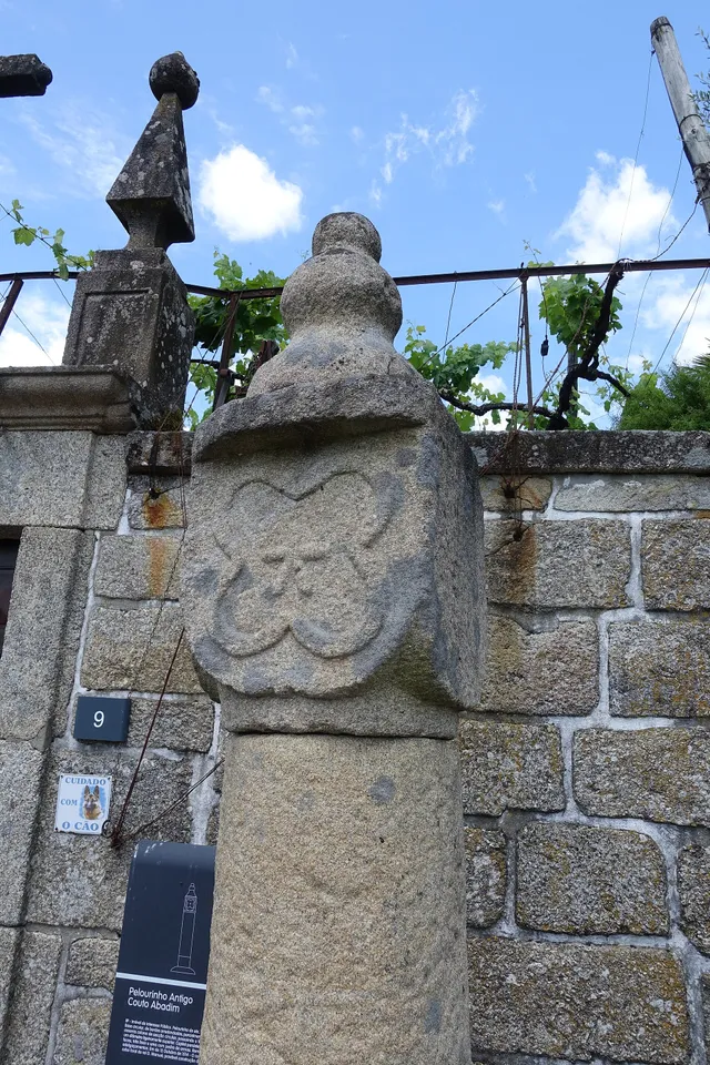
Details of the Pelourinho de Abadim in granite
Details of Pelourinho de Abadim. The star described in the text is not visible on this face.© Joseolgonⓘ

A small monument holds a history of autonomy.

Read here and view sources

The pillory of Abadim seems simple at first glance: a smooth column of granite, a cubic capite and a pear-shaped shot. But on one side you find a five-pointed star inside a four-lobe frame. The Museum links the monument to the administrative and judicial autonomy of the former Couto, extinguished in 1836. The Museum brings its construction closer to the foral of 1514, but the record of the Cultural Heritage warns that dating is difficult and that the piece can be quite later. The detail of the star invites you to look again at a piece that would easily go unnoticed.

The official record describes four faces on the capital: three undecorated and one with the star. This helps to understand why a photograph from another side may not show the best known reason. The record places the monument next to the portal of the House of Tower of Tronco and documents the classification as Public Interest Property in 1933. The date of protection is not the date of construction.

The foral, the stone age and the patrimonial classification answer different questions. Instead of automatically assigning ‘1514’ to the entire monument, compare the described form, the proposals for dating and the documents that changed its status.

Words in this story: see explanations →See Fact sheet: Pelourinho de Abadim
Source and context

Basto Land Museum / António P. Dinis — Pelourinho de Abadim, 26/01/2018
Accessed:

Cultural heritage — Pelourinho de Abadim, record 341971, historical-artistic note
Accessed:

Editorial summary; the date of consultation is not the date of the facts.
Faia · Parish memories of 1758

Chapels between the hill and the houses

The account of 1758 draws a small religious geography of Faia.

Read here and view sources

In 1758, the abbot of Faia placed Our Lady of Amparo on a hill and associated her with the captain-in-chief Manuel Baltasar de Abreu de Lima. Saint Anthony of Covilhã was presented as a chapel of the village itself, out of place. Santo António da Ribeira appeared next to the house of Leandro Machado, and Nossa Senhora da Piedade next to the house of Francisco de Moura Coimbra. The account adds that these chapels had no right pilgrimages. More than enumerating buildings, it distinguishes relationships between devotion, families and community. It is a portrait of that year, without indicating property, parties or current access conditions.

Getting to know the parish See Fact sheet: Capela da Senhora do Amparo da Faia
Source and context

Municipality — Parish Memoirs of Faia, 23/05/1758, replies 13 and 14; transcript of José Viriato Chapel (2003)

Accessed: . Editorial summary; the date of consultation is not the date of the facts.
Saint Nicholas · testimony of 1758

When the chapel shortened the path

The distance from the church also shaped the villages.

Includes an activity to try →Explore: Three Ways to Approach Places →
Read here and view sources

The memory of 1758 explains the function of three chapels: Saint Bartholomew, in Celeiró do Monte; Our Lady of Lapa, in Lapela; and Saint Anne, in Busteliberne. They served to administer sacraments to the residents who lived far from the matrix. A small building responded to a daily difficulty.

The dean Domingos Camel de Sousa describes high hills between the places and refers three settlements away half league from the church, in rough terrain. The distance was not only a line on the map: relief was part of the difficulty. The church was to spring, in a place with six neighbors, counting the house of the rector himself.

The three chapels were kept at the expense of the commendator, according to the report. But they were not the only ones: the text lists eleven chapels beyond the matrix, with different administrations and functions. In the Outeiro of Santo António, for example, it marks pilgrimages of neighboring parishes in the feasts of Santo António and Santa Luzia. The set reveals both the cult close to the residents and meetings that attracted people from outside.

Words in this story: see explanations →Getting to know the parish See Fact sheet: Busteliberne See Fact sheet: Igreja de São Nicolau de Cabeceiras
Source and context

Basto Land Museum — St Nicholas Parish Memories (1758)

Accessed: . Editorial summary; the date of consultation is not the date of the facts.

Arco de Baúlhe · railway memories

Before the train, the tiles arrived

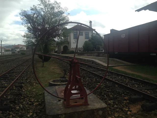
Revolving plate and tracks from the old Arco de Baúlhe station, with buildings and railway equipment at the bottom.
Facade of the station of Arco de Baúlhe, with coating and tile panels visible to the background. View of JP Ribeiro; it is not a detail of the panels of 1940.© JP Ribeiroⓘ

The station also reads on the walls.

Includes an activity to try →Explore: A station, different spaces →
Read here and view sources

The station panels were executed in 1940 by A. Lopes, at the Sant’Anna Ceramic Factory in Lisbon, according to the publication of the Basto Land Museum. They are prior to the opening of the station in 1949.

The station was a set of spaces with different functions. The publication identifies the driver's house, the staff building, the loading and unloading dock and the dispatch warehouse. The two stalls started to host permanent exhibitions of railway equipment; the warehouse is described as temporary exhibition space.

Reading the building can begin with these differences: where were they working, where were goods passing and where were they stored? The tiles are part of this built landscape. The description documents the museological organization presented in the publication, without confirming the exhibition or access of each space today.

Getting to know the parish See Fact sheet: Núcleo Ferroviário de Arco de Baúlhe
Source and context

Municipality — Land Museum of Basto: a journey through the history of the region, pp. 28–29

Municipality — Núcleo Ferroviário de Arco de Baúlhe

Accessed: . Editorial summary; the date of consultation is not the date of the facts.

Heritage of Abadim

A tower to look slowly

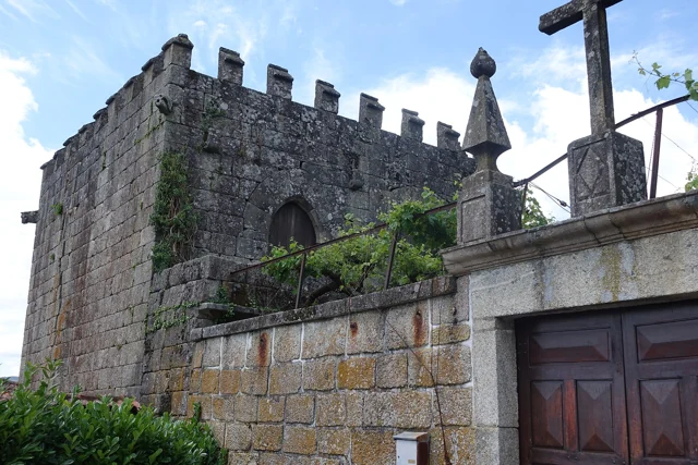
Tower of Abadim, with yellow crowning and stone constructions around.
Tower of Abadim · yellow crowning and surrounding constructions.© Joseolgonⓘ

History is also read in windows and corners.

Explore: Read the marks of power and time →
Read here and view sources

The Tower of Abadim has battlements at the top and gargoyles with animal shapes in the corners. António P. Dinis highlights the settery, the broken arch doors and, inside, conversationals next to the windows. It proposes a construction of the sixteenth century, perhaps from the foral period, without setting an exact date.

The memory of 1758 places the tower in the middle of the Village of the Tower and states that it did not suffer ruin in the earthquake of 1755. The same document describes Abadim with ordinary judge and Chamber, in an organization proper to the former Couto. Reading architecture and administration together helps to understand the importance of the building; the interior description does not confirm current access.

The text of António P. Dinis distinguishes the probable place of the medieval manor from the quintentist construction described today. It is not necessarily the same building preserved without change. The designation Casa do Tronco accompanies the hypothesis that here the justice and the chain of trust functioned.

In the memory of 1758, the election of the ordinary judge and of the House was presided over by the donate. The document also refers to the intervention of the Guimarães magistrate in correction or new scope. Thus, the existence of own organs should not be confused with an administration without relations with other authorities.

Words in this story: see explanations →See Fact sheet: Torre de Abadim / Casa do Tronco
Source and context

Basto Land Museum / António P. Dinis — Tower of Abadim, 17/01/2018

Municipality — Parish memories of Abadim, José Antunes, 22/05/1758

Accessed: . Editorial summary; the date of consultation is not the date of the facts.

Faia · settlement described in 1758

A parish told by sixteen places

In 1758, the Faia appears as a network of small places.

Includes an activity to try →Explore: A parish distributed by places →
Read here and view sources

In memory of 23 May 1758, the abbot João de Lima Lobo de Noronha enumerates sixteen places. The enumeration includes Covilhã, Augueiros, Presas, Nogueira, Candedo, Ribeiro, Outeiro, Porcarice, Faia, Togais, Souto, Ribeira, Tuesdays, Breia, Casa Nova and Joio. Situa the church out of place and describes the parish on a northern slope.

The list helps to think of a territory distributed by small cores, and not just around the matrix. Names belong to historical transcription; they are not a current administrative list or allow to draw the boundaries of each place by themselves.

The same testimony presents two counts: 99 neighbors and 418 people. The document separates them; they should not add or read “neighbours” as another total of inhabitants. It also distinguishes scales: when speaking of the municipality, the abbot refers to eighteen parishes, but declares not knowing the number of its neighbors. Knowing what the author did not tell is as useful as knowing the numbers he left.

Ribeiro and Ribeira appear as different entries. Outeiro is here in the list of places of Faia: the coincidence with the name of another parish does not authorize to shift this reference on the map. The complete list allows to compare names, while chapels help to perceive some relations between places and houses.

Source and context

Municipality — Memory of Faia, 23/05/1758; transcript of José Viriato Chapel (2003)

Accessed: . Editorial summary; the date of consultation is not the date of the facts.

Refojos · history of assistance since 1877

Care is also part of the story

Mercy was born of a local initiative in the 19th century.

Read here and view sources

The review of Santa Casa places its constitution in September 1877, with the purpose of supporting poor people who needed health care. The first statutes were approved in January 1879. In 1896 opened a hospital, replaced in the years 1950 by the Hospital Professor Julio Henriques. The institution highlights the contribution of the population to this new unit. These dates help follow a history of assistance and cooperation; they do not describe the health services available today.

Source and context

Santa Casa da Misericórdia of Cabeceiras de Basto — historical review of the institution

Accessed: . Editorial summary; the date of consultation is not the date of the facts.

Refojos · 19th and 20th century transformations

After the monks, other lives

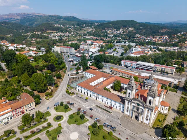
Air view of the Monastery of São Miguel and the Republic Square in Refojos
Current view of the Monastery of Refojos and the square; it is not an image of the nineteenth-century uses.© Vitor Oliveira from Torres Vedras, PORTUGALⓘ

Camera and school are also part of the history of the building.

Explore: The building changed its life by stages →
Read here and view sources

The extinction of religious orders, in 1834, changed the fate of the set of Refojos, keeping the church in the religious function. According to the municipal proposal of patrimonial candidacy, João António Fernandes Basto acquired the Monastery in public haste between 1838 and 1842. In the nineteenth century, the assembly also welcomed municipal services; in 1944, another part received a college with boarding school. Looking at the whole is also to discover how ancient buildings were adapted to administration and teaching.

The document places around 1855 the installation of the city services in the part of the cloisters. For the school area, it registers a new change of ownership in 1959, for the Conciliar Seminary of Braga. The group therefore did not have a single destination after 1834: different parts followed their own stories. The heritage proposal is here a historical source; it does not demonstrate a UNESCO classification nor confirms the current uses of each space.

Words in this story: see explanations →See Fact sheet: Mosteiro de São Miguel de Refojos
Source and context

Municipality — proposal for a heritage registration of the Monastery, pp. 9 and 11; later uses in p. 11 (candidature document, not a UNESCO classification)

Basto Land Museum — The place of the Pereiras of Refojos de Basto, 28/07/2024

Accessed: . Editorial summary; the date of consultation is not the date of the facts.

Refojos · provenance of a piece preserved in Coimbra

A cup full of characters

A small piece of gold silver holds a medieval connection to Refojos.

Read here and view sources

The Machado de Castro National Museum identifies this 12th century chalice as an offer by D. Gueda Mendes to Mosteiro de São Miguel de Refojos. The decoration invites to look at parts: in the cup are Christ and the Apostles, under round arches; at the base appear the symbols of the four evangelists. The form indicates unknown authorship and locates the piece in Coimbra. Knowing its provenance allows discovering heritage linked to Cabeceiras which is outside the municipality.

See Fact sheet: Mosteiro de São Miguel de Refojos
Source and context

Museu Nacional de Machado de Castro — Cálice, ficha da coleção no Google Arts & Culture

Accessed: . Editorial summary; the date of consultation is not the date of the facts.

Santa Senhorinha · landscape described in 1758

A valley full of names

In 1758, the parish also counted for its seats.

Includes an activity to try →
Read here and view sources

The parish report places Santa Senhorinha in a valley between the Gatiras and the Ladario. It lists places such as Rendufe, Soutelo, Outeiro Seco, Olela, Devesa and Vila Garcia, among many others. The church is described outside the village, in the middle of a field. This portrait allows you to imagine a community distributed across several cores, but retains the names and perspective of the document of 1758, without functioning as a current map.

The author also lists villages that were seen, distinguishing the position in the valley of the look from the Ladário. Visibility was part of the way of presenting the territory. A place could be described by what surrounded it and by what could be seen from a higher point, beyond its limits and names.

Source and context

Municipality — Parish Memories of Santa Senhorinha (1758), replies 4 and 6; transcription of José Viriato Chapel (2003)

Accessed: . Editorial summary; the date of consultation is not the date of the facts.

Rio Douro · places and hermits described in 1758

Fifteen places, a network of chapels

The distance from the church also shaped the lives of the villages.

Includes an activity to try →
Read here and view sources

In the memory of Rio Douro of 1758, the vicar lists fifteen places and places the church outside the village. He also refers to fifteen hermits, explaining their relationship with religious assistance to people living far from the home.

St. Stephen stayed outside Eiró; other invocations accompanied names of villages, such as Santa Ana in Toninha, São Gonçalo in Vilela and São Frutuoso in Leiradas. The document also distinguishes religious responsibilities from Refojos, private and residents. It is a historical network of places, devotions and care, without confirming the conservation or current access to each building.

Source and context

Municipality — Parish Memoirs of Rio Douro, António Carneiro da Costa, 22/05/1758

Accessed: . Editorial summary; the date of consultation is not the date of the facts.

Cavez · history of the bridge of Moimenta; current conditions not verified

Two seasons on the same bridge

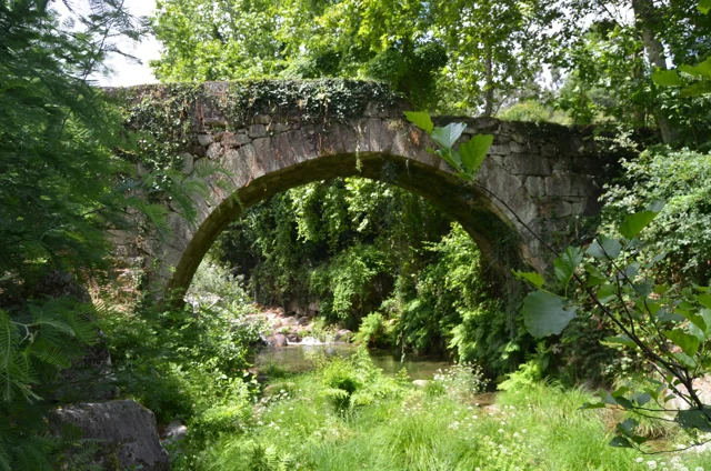
Ponte antiga de Moimenta in Cavez: stone arch over the river, surrounded by vegetation, photographed in June 2020.
Moimenta Bridge, photographed by Pedro at 11 June 2020. A crossing record other than Ponte de Cavez over Tâmega.© Pedroⓘ

In Moimenta, the ancient stone coexists with an intervention of 1990.

Read here and view sources

An ancient bridge can continue to change. The municipality attributes medieval origin to the bridge of Moimenta in Cavez, and describes a single round arch.

In 1990, the passage was extended about one meter: it received a concrete structure on the downstream side and the guards were changed. The photograph allows to begin to observe the crossing; the date of the intervention comes from the documentary description.

Words in this story: see explanations →See Fact sheet: Ponte antiga de Moimenta
Source and context

Municipality — Cultural heritage, bridges of Arco de Baúlhe and Moimenta

Accessed: . Editorial summary; the date of consultation is not the date of the facts.

YOUR LOCAL GUIDE

What would you like to discover?

Take a closer look.