Discover Cabeceiras de BastoFree independent guide
ViveCabeceirasYOUR GUIDE TO CABECEIRAS
ENEnglish
SearchSaved

Stories of Cabeceiras

Choose a story to start with. You can change the subject or fine tune the search.

23 leituras · Todos os temas · Rio Douro

The flavours of Cabeceiras

From the garden to the pot, from the oven to the table.

Escolher uma história · 1
Rio Douro · agriculture in 1758

From valley to hill, the harvest changed

The landscape also chose the pantry.

Inclui uma atividade para experimentar →Explorar: Segue a paisagem até à despensa →
Read here and consult sources

In Rio Douro, the report of 1758 distinguishes the production of the places by the rivers from the places of mount. To the first associates millions, wine, chestnut and acorn; to the second, rye. The landscape also helps to read the pantry.

In describing the shores, the parish priest refers to fields with oaks and vines and, where there were no fields, woods of heather. The same document depicts cold, windy mountains and with snow in winter. They are historical descriptions that allow to relate cultivation and land, without constituting a current agricultural or climatic survey.

Getting to know the parish
Source and context

Municipality of Cabeceiras de Basto — Parish memories of 1758: Rio Douro

Accessed: . Editorial summary; the date of consultation is not the date of the facts.
The life you don't always see

Knowing animals begins by perceiving the territory and respecting the distance.

Escolher uma história · 3
Rio Douro · fauna testimony in 1758

The fish of an ancient portrait

Trouts, bogas and scallops appear in the Memories of Rio Douro.

Read here and consult sources

Trouts, bogas and scallops are the names registered by the vicar of Rio Douro in 1758. It highlights trout as more numerous and distinguishes winter fishing from summer. They are assessments of the report, without counting that allow to measure abundance.

The testimony brings fauna closer to the uses of water and the lives of villages. Ancient common names do not equal complete scientific identifications; the practices described also do not establish the current rules of fishing.

Getting to know the parish
Source and context

Municipality of Cabeceiras de Basto — Parish memories of 1758: Rio Douro

Accessed: . Editorial summary; the date of consultation is not the date of the facts.

Species biology · registered at Rio Douro

A small frog, a large water connection

There are lives that depend on both the shore and the brook.

Inclui uma atividade para experimentar →Explorar: Uma fotografia abre outras perguntas →
Read here and consult sources

The Iberian frog lives naturally on the Iberian Peninsula: that is what it means to be an endemic species of this territory. With slender body and pointed snout, it can reach about 5,5 centimeters. Reproduction happens in the water, and the species prefers mountain streams with vegetation on the shores and rocky bottom.

The photograph recorded in Rio Douro opens a window for this discreet life. It does not in itself demonstrate the quality of water: pollution and the change in riverside habitats are among the threats described by the University of Évora.

The description also highlights a dark strip that crosses the eye zone, with a narrower stripe underneath. They are details to enjoy in a photograph, without handling the animal.

Source and context

University of Évora — Virtual Museum of Biodiversity

Accessed: . Editorial summary; the date of consultation is not the date of the facts.

Rio Douro · animals mentioned in 1758

The animals that remained in the memory of the mountains

A list of 1758 mixes encounters, abundances and passages.

Read here and consult sources

The vicar of Rio Douro names rabbits, hares, partridges, wolves, foxes and badgers when describing the mountains in 1758. Adds mountain pigs of passage and places the partridges only in some parts. These language differences are part of the testimony and deserve to be preserved.

The report describes cold, windy and snowy mountains in winter. It brings animals and landscape closer, but does not present counts, observation methods or a scientific inventory. It does not allow to conclude that all the mentioned species continue in the same places today.

Source and context

Municipality — Parish Memoirs of Rio Douro, António Carneiro da Costa, 22/05/1758

Accessed: . Editorial summary; the date of consultation is not the date of the facts.

Read the landscape through the plants

Trees, forests, vineyards and fields reveal different ways of occupying the territory.

Escolher uma história · 1
Local register · Rio Douro · general botany

Not all leaves sting the same way

The holly holds differences even in its branches.

Inclui uma atividade para experimentar →Explorar: Olhar para a planta inteira →
Read here and consult sources

Referred to Cabreira by Visit Cabeceiras, Ilex aquifolium has persistent leaves. Gulbenkian's record describes thorny margins, but sometimes smooth in older branches or individuals. Red fruits appear in female specimens and are toxic. A detail to observe, no spoon or taste. Flowering usually occurs between April and June; fruits ripen at the end of summer and can remain during winter, according to Gulbenkian.

The small white flowers pass more unnoticed than the fruits. The mistletoe is dioic: there are male and female individuals. This separation helps to understand why not all specimens have red fruits.

It is a slow growing shrub, which can exceed a century of life. Gulbenkian describes it in coals and shrubs, often on dark and moist slopes, with soils slightly acidic and rich in organic matter. Watching the plant therefore includes looking at the environment around it, beyond the contour of the leaves.

The photograph of DVG, registered in 2026-04-03, shows this species in Rio Douro. It opens the register to compare the visible details with the botanical description. The observation documents this encounter; it does not indicate that the plant is always visible in the same place.

Palavras desta história: ver explicações →
Source and context

Visit Cabeceiras — natural heritage of Serra da Cabreira
Accessed:

Calouste Gulbenkian Foundation — Ilex aquifolium, characteristics and habitat
Accessed:

iNaturalist — Ilex aquifolium, DVG observation in 2026-04-03
Accessed:

Editorial summary; the date of consultation is not the date of the facts.

Between rivers and mountains

Water and relief form the municipality. Choose a name and follow the landscape.

Escolher uma história · 5
Landscape · Rio Douro

Moscoso look at the valley

mountains houses, a stream and a name that stays in your ear.

Inclui uma atividade para experimentar →
Read here and consult sources

Moscoso, in the parish of Rio Douro, is presented by Visit Cabeceiras as a preserved nucleus of rustic houses of Serra da Cabreira. The village turns to the valley of the river of Cavez, where the description is located the Nariz do Mundo. In the vicinity, it also mentions the waterfall of the Poço das Relvas.

To read this landscape, try to separate three elements: the houses, the valley and the relief in the background. Then put them back together: the village gains context when it is no longer just a set of buildings. The places chips help to continue the discovery; this description does not define a path between them.

See Fact sheet: Moscoso See Fact sheet: Nariz do Mundo
Source and context

Visit Cabeceiras — village Moscoso

Accessed: . Editorial summary; the date of consultation is not the date of the facts.

Ribeira de Cavez · water and agriculture

From the spring to the fields

A stream helps explain the whole landscape.

Read here and consult sources

The brook of Cavez is born on the border of the municipality with Montalegre and ends at Tâmega. Between the mountain and the mouth, the municipal description highlights levadas, mills and irrigation mills: buildings and fields that show different ways to enjoy the water.

On the trail beginning in Vilela, Rio Douro, the narrative goes from the descent to the riverside to the levada and the landscape of the lameiros, then following rural paths and the slope. The return to the village brings another material to the history: the granite masonry of the houses. See the route chart to prepare the walk; this reading explains the landscape, without confirming the conditions of the way on the day of the visit.

Getting to know the parish See Fact sheet: Trilho da Ribeira de Cavez See Fact sheet: Vilela, Rio Douro
Source and context

Municipality — stream of Cavez and agricultural landscape

Accessed: . Editorial summary; the date of consultation is not the date of the facts.

Rio Douro · Parish memories of 1758

Two rivers to count a parish

The report of 1758 organizes Rio Douro between spring and west.

Inclui uma atividade para experimentar →Explorar: Água que liga aldeias e trabalhos →
Read here and consult sources

In the account of 1758, the Vilela River ran the spring and the river from Rio Douro to the west, both from north to south. The parish priest described origins in small sources and the increase in waters with the contributions of the mountains. He said that Vilela entered the Tâmega below the bridge of Cavez and that the other joined the river coming from São Nicolau. They are geographical names and relations of that document, not a current navigation map.

The bridges bring this geography closer to the life of the villages. The document mentions a wooden crossing between Magusteiro and Teixeiras and a stone one between Teixeiras and the church. It also mentions wooden connections of Eiró and Rio Douro to the church, and another stone between Vilela and the church. Water and paths appear, thus, in the same portrait of the parish.

The parish priest describes rivers with rocks, dams and waterfalls, inadequate to navigation, but useful to mills and fields. They were not only lines to separate places: they were part of work and displacements. These references belong to the testimony signed in 22 May 1758; they do not confirm the conservation of structures or the current access to the margins.

There is a clue to imagine the relief: the author describes three parallel mountains, extended from Salto, with the rivers in the lower spaces. The names of the mountains varied according to the places. Instead of looking for a single name for each mountain line, the document invites to relate position, villages and direction of the water.

Palavras desta história: ver explicações →Getting to know the parish
Source and context

Municipality of Cabeceiras de Basto — Parish memories of 1758: Rio Douro

Accessed: . Editorial summary; the date of consultation is not the date of the facts.

Rio Douro · water uses in 1758

In summer, the water took other paths

The levadas linked the flow of rivers to the work of the fields.

Inclui uma atividade para experimentar →Explorar: A água ligava trabalhos e lugares →
Read here and consult sources

The memory of 1758 describes the two rivers of Rio Douro running all year round, but arriving at the end of the course with little water in the summer. The vicar linked this decrease to the many levadas that supplied the fields. Dams, waterfalls and mills comprised a landscape of various works.

The crossings also varied: the report mentions wooden bridges between places and the church, as well as stone bridges in Teixeiras and Vilela. The margins were not just production spaces; it was necessary to move from one side to the other. This historical enumeration does not identify surviving structures or current accesses.

The document also explains why boats did not circulate: there were stones, waterfalls and dams, and insufficient flow for navigation. A river could be important for the economy of the parish without being a river transport route.

On the cultivated shores, the report mentions vine oaks; outside the fields, urzeira forests. Thus, the water helped to organize a landscape in which cultivation, vegetation and equipment were found. The answer was signed in 22 May 1758: summer is described as usual behavior, not as a measurement carried out this summer.

Palavras desta história: ver explicações →Getting to know the parish
Source and context

Municipality of Cabeceiras de Basto — Parish memories of 1758: Rio Douro

Municipality — Parish Memoirs of Rio Douro, António Carneiro da Costa, 22/05/1758

Accessed: . Editorial summary; the date of consultation is not the date of the facts.

Rio Douro · project announced in April 2025

In the wasteland, the forest finds the water lines

A project of Rio Douro helps to read different functions of the same landscape.

Inclui uma atividade para experimentar →Explorar: A encosta encontra o rio →
Read here and consult sources

In April 2025, Antar announced the start of an intervention agreed with the local wasteland community of Riodouro, in an area of about 500 hectares of Cabreira partially affected by the fires of 2016 and 2024. The plan presented combined forest production, conservation and recovery of about 40 hectares of riverside vegetation. The proposal helps to realize that managing a hillside also involves water spaces. These figures are objectives announced by the promoter, not a confirmation of completed work or results achieved.

The April news places the beginning of the work in February 2025. For the first phase, it announces about 220 hectares of production species and about 80 hectares of diverse leaves and resins. These areas have different purposes; they are not a balance of plantations carried out.

The relief also enters the project: the promoter describes plateaus, steep slopes and great variation of altitude. The reading of the landscape joins, thus, the form of the land, production spaces and sensitive areas next to the water. There is no complete division here of the 500 hectares that allows to draw all the plots.

Source and context

Antar — announcement of the start of the Riodouro project, 04/04/2025; objectives announced by the promoter

Accessed: . Editorial summary; the date of consultation is not the date of the facts.

Crafts and memories

In the hands, at the table and in the community: little stories of how one lives and what one transmits.

Escolher uma história · 6
Formigueiro · labour assets

Water also worked wool

Wool and cereals: two works on the same stream.

Inclui uma atividade para experimentar →Explorar: A mesma água, trabalhos diferentes →
Read here and consult sources

Next to the brook of Cavez, an old building gathered the work of wool and cereals: there it was trampled — tightened — wool and milled. The municipal description places the ruins at the descent of Formigueiro. The trail allows to know this memory of the work; access to the interior is not confirmed.

It is important to separate operations: treading wool and grinding cereal are different jobs, although the description gathers them in that building. One cannot imagine a single machine producing flour and treating wool without documentation of the mechanism. The municipal presentation refers to traces of artifacts in the ruins, but does not offer an inventory that allows to reconstruct all the pieces.

The same landscape connects work and relief. Formigueiro is above the pison, in a descent that the source describes as accentuated; the Nariz do Mundo corresponds to another element of the route, aimed at reading the valley. Knowing the history of the device and preparing a walk are complementary tasks: distance, difficulty and conditions belong to the track record.

Getting to know the parish See Fact sheet: Trilho do Pisão e Nariz do Mundo
Source and context

Municipality — the former pison near the brook of Cavez

Accessed: . Editorial summary; the date of consultation is not the date of the facts.

Formigueiro · weaving and trade

Fabrics leaving the village

From wool and linen to São Miguel and Santa Luzia fairs.

Read here and consult sources

The memory of Formigueiro gathers blankets, quilts, towels and blankets made of wool, linen and rags. The municipal guide links its sale to the fairs of São Miguel, in Cabeceiras, and Santa Luzia, in Arco de Baúlhe.

Following these fabrics is connecting the work within the village to the movement of people and goods. The report retains a commercial memory, not a list of current banks.

Getting to know the parish See Fact sheet: Formigueiro
Source and context

Municipality — Village Guide of Serra da Cabreira: landscape, work and heritage

Accessed: . Editorial summary; the date of consultation is not the date of the facts.

Cambezes · Rio Douro · rural memory

The herd was also a village matter

In Cambezes, the inter-help reached the pastures.

Inclui uma atividade para experimentar →
Read here and consult sources

The municipal guide presents Cambezes through archaeological remains, legends and a life marked by mutual help. It highlights collaboration in tasks and shepherding instead.

This memory invites you to look at the village beyond the houses: also the relationships between people are part of the heritage. The source does not describe the scale of pastors nor confirms a current calendar.

The turner highlights a way to organize shepherding among inhabitants. To understand how it worked in Cambezes, it would be interesting to know the rules, the participation of houses and changes over time. The guide does not provide these details. The collaboration mentioned is a starting point to collect memory, not a ready scale of tasks.

Compare this story with the water shifts of Levada de Víbora: both speak of collective organization, but only the leva survey describes eleven shifts of twenty-four hours. Transporting this rule to Cambezes' flock would invent a similarity that sources do not demonstrate.

Getting to know the parish
Source and context

Municipality — Village Guide of Serra da Cabreira: landscape, work and heritage

Municipality — Extension of water supply network in Cambezes, Riodouro (place of village)

Accessed: . Editorial summary; the date of consultation is not the date of the facts.

Vilela · Rio Douro

The granite also draws the village

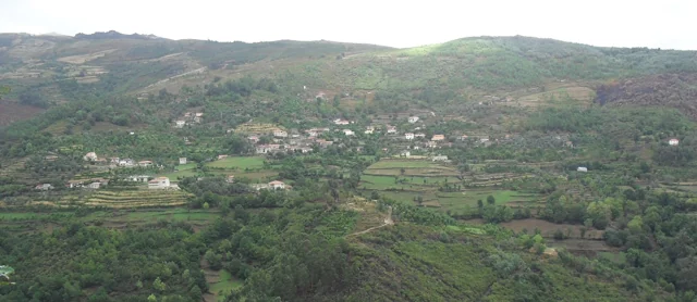
Panoramic view of Vilela, Rio Douro, with houses and agricultural plots on the slopes.
Vilela · architecture and landscape of Rio Douro© Ambcruzⓘ

In Vilela, the walls help to recognize the landscape.

Inclui uma atividade para experimentar →
Read here and consult sources

The municipal presentation of the Cavez stream trail highlights the granite masonry in the old streets of Vilela, in Rio Douro. After the levadas and the lameiros, the reading of the territory continues in the houses: the material of the region also participates in the form of the settlement.

The municipal text presents a sequence that unites buildings and agricultural work: levadas, mills and lameiros de regádio precede the description of the streets of the village. Vernacular architecture is here the construction linked to the materials and practices of the place. The granite does not appear only as rock of the landscape; it enters the walls and the visual organization of the settlement.

To explore this relationship, it compares Vilela's photograph with reading on granite grains. A view of the village shows volumes and surfaces; a close look at the rock shows another scale. The municipal description does not date each house nor allows to conclude that all the walls have the same history.

Palavras desta história: ver explicações →Getting to know the parish See Fact sheet: Vilela, Rio Douro See Fact sheet: Trilho da Ribeira de Cavez
Source and context

Municipality — stream of Cavez and agricultural landscape

Accessed: . Editorial summary; the date of consultation is not the date of the facts.

Casa da Lã and Women of Bucos · knowledge sharing, 2024–2026

The wool of Bucos also travels by the hands of those who teach

Preserving a trade includes showing it to other people.

Inclui uma atividade para experimentar →Explorar: Encontros que põem o saber em partilha →
Read here and consult sources

In 10 October 2026, the women of Bucos participated in the Wool Cycle in Santo Tirso, representing Casa da Lã. The news from the Museum describes demonstrations of fiber preparation, spinning and weaving. It is a documented episode of the transmission of this knowledge outside the municipality, not an announcement of a future activity.

The sharing had already passed through Casa da Lã in 14 March 2024: the Women of Bucos received the Women of Atelier Pontinhos, from the Interpretative Center of Mines of Borralha, at a meeting dedicated to this work.

In 6 June 2026, Casa da Lã received the Day of Sweating. The news published two days later describes demonstrations guided by Women of Bucos, with public participation and collaboration from the Board of Freguesia. It is another documented example of learning between generations, not a date of future activity.

The transmission also approached Bucos of Rio Douro. In the report of 21 October 2024 on the workshop From Wool to Yarn and Feltro, in Landra, the Municipality records the participation of women of Bucos. They showed tasks like washing, squabbling, carding and spinning. The initiative integrated the Saber a Terra project, which articulated learning, artistic creation and relationship with local ecosystems. The news announced another session for the following weekend; this forecast is not treated here as proof of realization.

See Fact sheet: Casa da Lã
Source and context

Basto Land Museum — Women of Bucos promote ancestral wool art in Santo Tirso, 2026-10-14

Museum of Lands of Basto — “The wool that unites us” brought together women from Bucos and the Mines of the Rubber Casa da Lã, 2024-03-19

Basto Land Museum — shear day Bucos, 2026-06-08

Municipality — From Wool to Yarn and Feltro, Landra in Riodouro, 21/10/2024

Accessed: . Editorial summary; the date of consultation is not the date of the facts.

Rural heritage · survey of 2008

One water, several jobs

In Eiró, the work of the mill was linked to the irrigation of the fields.

Read here and consult sources

The inventory of February 7, 2008 describes the Lagar da Casa da Portelada, in Eiró, Rio Douro, associated with a mill in the same building, with independent entrance. The water of the Levada de Millos served the equipment before going to the irrigation. This successive use connected food processing and agriculture. Private property registration does not confirm current visiting conditions.

The chart situates the old work of the mill in January and February. It also describes the arrival of water on the west side, through a granite structure, and distinguishes the entrance of the mill, to the north, from the entrance of the mill, to the south. They are clues to read the organization of the building. The document contains contradictory indications about the preserved parts; therefore, it does not allow to state that the set was complete or operational.

Source and context

Municipality — Lagares inventory, LA20 fiche, Portelada House (07/02/2008)

Accessed: . Editorial summary; the date of consultation is not the date of the facts.

Time travel

Documents, details and traditions: there is more to discover than a date on a stone.

Escolher uma história · 7
Rio Douro · archaeological interpretation

A castle you read on the ground

In Eiró, the circular shape and moat tell a story.

Inclui uma atividade para experimentar →Explorar: O terreno e os documentos →
Read here and consult sources

The municipal inventory interprets the vestiges as a fortified motorcycle-type residence from the middle of the 13th century. It relates it to the castle referred to in the 1258 Inquisitions. The circular shape rests on a stone and gravel landfill, surrounded by a moat. The municipality highlights the position over the valley of Rio Douro, link between Refojos and the plateau Barrosão. The reading combines ground and document, without reconstructing the missing building for sure.

The document of 1258 adds a social dimension to the form of the land: according to the municipal interpretation, almost all residents of Santo André of Rio Douro had an annual obligation to move to the castle. The reference links fortification to the community organization, although it does not clarify here all the associated tasks.

The inventory compares construction with examples from Brittany. It is a comparison of forms and techniques, not a proof of the origin of its builders. The location in the middle of the hillside helps to understand the relationship between defense and passage through the valley.

Getting to know the parish
Source and context

Municipality — archaeological inventory, interpretations and chronologies

Accessed: . Editorial summary; the date of consultation is not the date of the facts.

Rio Douro · archeology and oral tradition

The village that stayed in memory

The traces of the Old Village of Toninha count for another time.

Inclui uma atividade para experimentar →Explorar: Outras pistas no território →
Read here and consult sources

In the Old Village of Toninha, the municipal inventory proposes occupation between the 13th and 16th centuries. It compares the constructive remains with other serran settlements, including examples in Lindoso and the abandoned village of Juriz in Montalegre. Already the plague that would have caused the people to leave belongs to the popular tradition. They are different paths to know the place: comparing buildings and collecting memories.

There is a third clue: the Investigations of 1258. The inventory proposes that the village may correspond to one of the ten couples then assigned to Juguelhe. It is a probable identification presented by the author, not an equivalence demonstrated. Comparisons with other places help to formulate this interpretation.

Imagine three cards on the table: the buildings, the document of 1258 and the narrative of the plague. Each opens a different question. What forms are repeated in other villages? What places appear in the document? What explanation conveyed the tradition? The discovery begins by crossing these clues without confusing them.

Getting to know the parish
Source and context

Municipality — Old village of Toninha: proposed chronology, parallels and inquiries of 1258

Accessed: . Editorial summary; the date of consultation is not the date of the facts.

Rio Douro · medieval archaeology

Two graves, one direction

In Rio Douro, guidance helps to interpret the past.

Read here and consult sources

In the Moira Camps, the Municipality describes two oriented graves from east to west. It includes them in the Christian funeral practices of the Northwest and presents a broad chronology between the 9th and 13th centuries. The name of the place and the interpretation of traces are different clues, which should be read together.

The record uses the term inhumation: it is about burying the body. The east–west direction and general configuration are elements of the interpretation presented, while the 9th to 13th centuries delimit an interval of several centuries, not an exact date.

Compare these graves with Asnela's mammoths helps to avoid a unique reading of all that is ancient. Both are funeral testimonies, but the inventory proposes periods and types of different structures. The name of a site does not replace the analysis of its traces.

Palavras desta história: ver explicações →Getting to know the parish
Source and context

Municipality — archaeological inventory, interpretations and chronologies

Accessed: . Editorial summary; the date of consultation is not the date of the facts.

Rio Douro · archaeological interpretation

A village drawn on the hillside

In Monte do Castelo, relief is part of history.

Read here and consult sources

The municipal inventory proposes the existence of a small fortified village of the first millennium before Christ. The interpretation is based on the platforms of the land and on the position over an irrigated area. It is not necessary to imagine a medieval castle: here, the word of the toponym accompanies traces of another era.

The small elevation and regular platforms are two clues used in the interpretation. The position allows mastering an irrigated floor extending north. The argument thus combines the form of the land with the relationship between the village and the surrounding area; the toponym alone does not solve dating.

Getting to know the parish
Source and context

Municipality — archaeological inventory, interpretations and chronologies

Accessed: . Editorial summary; the date of consultation is not the date of the facts.

Chacim · interpretation of romanization

Between the mountain and the valley, the settlement changed

Romanization also changed the relationship between the mountain and the fields.

Explorar: Que pistas contam esta mudança? →
Read here and consult sources

Romanization did not have the same effect on all villages. The Archaeological Letter places changes in the second half of the 1st century before Christ: Chacim will have strengthened its centrality, while the small castre of Arco de Baúlhe seems to have lost inhabitants. The text presents an interpretation of traces, not a census of movements.

In Chacim, Mó de Cima’s materials are associated with the occupation and cultivation of nearby lowlands. Later, the description also points to open agricultural establishments, such as the couple identified in Abadim. History is therefore not limited to abandoning the highlands: it involves new centers and different ways of occupying the fields.

The same source relates cultural transformation to sculptures of warriors and honorific inscriptions. They are clues of different natures: one helps to think about social representation, another allows to read signs of Roman practices. When exploring these stories, it is worth asking whenever trace supports each interpretation.

Getting to know the parish
Source and context

Archaeological Letter of Cabeceiras de Basto — Protohistory and Romanization

Municipality — archaeological inventory, interpretations and chronologies

Accessed: . Editorial summary; the date of consultation is not the date of the facts.

Rio Douro · hypothesis of relationship between archaeological sites

Tombs and village: an uninvestigated connection

At Portela de Asnela, the landscape leaves a question.

Explorar: Comparar vestígios, distinguir hipóteses →
Read here and consult sources

The municipal inventory describes mamoas in Portela de Asnela, in Rio Douro, and proposes a relationship with the village of Castelo, in Formigueiro, about a kilometer north. Proximity supports a hypothesis; it does not in itself prove that the two sets were used by the same community.

The fiche identifies structures of the anther and cyst type within the funerary assembly. It proposes a dating in the second or first millennium before Christ, supported by ceramic materials and in comparison with similar sets of the Northwest mountains.

There are therefore two distinct questions: when will these monuments have been built and what connection could they have had with the nearby village? A proposal for chronology does not automatically solve the second. The inventory presents this connection as a hypothesis, preserving space for future research.

Palavras desta história: ver explicações →
Source and context

Municipality — archaeological inventory, interpretations and chronologies

Accessed: . Editorial summary; the date of consultation is not the date of the facts.

Rio Douro · places and hermits described in 1758

Fifteen places, a network of chapels

The distance from the church also shaped the lives of the villages.

Inclui uma atividade para experimentar →
Read here and consult sources

In the memory of Rio Douro of 1758, the vicar lists fifteen places and places the church outside the village. He also refers to fifteen hermits, explaining their relationship with religious assistance to people living far from the home.

St. Stephen stayed outside Eiró; other invocations accompanied names of villages, such as Santa Ana in Toninha, São Gonçalo in Vilela and São Frutuoso in Leiradas. The document also distinguishes religious responsibilities from Refojos, private and residents. It is a historical network of places, devotions and care, without confirming the conservation or current access to each building.

Source and context

Municipality — Parish Memoirs of Rio Douro, António Carneiro da Costa, 22/05/1758

Accessed: . Editorial summary; the date of consultation is not the date of the facts.

YOUR LOCAL GUIDE

What would you like to discover?

Take a closer look.