Discover Cabeceiras de BastoFree independent guide
ViveCabeceirasYOUR GUIDE TO CABECEIRAS
ENEnglish
SearchSaved

Story

Choose a story to start with. You can change the subject or fine tune the search.

13 stories · Time travel · Search: pontes

Time travel

Documents, details and traditions: there is more to discover than a date on a stone.

Choose a story · 13
Cavez · Parish memories of 1758

A bridge that deserved praise
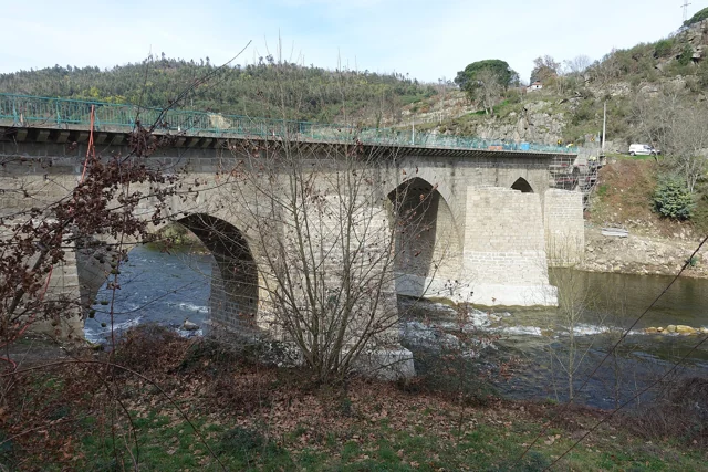
Ponte de Cavez on the river Tâmega, with stone arches, board and wooded banks.
Ponte de Cavez · crossing Tâmega© Joseolgonⓘ

In 1758, the Cavez Grand Bridge impressed the parish priest.

Explore: Two shores, several stories →
Read here and view sources

In the parochial memory, the crossing of the Tâmega appears described as a great stone bridge, well worked. The author even considers it the best of that river. The praise belongs to the look of those who wrote: it reveals the importance it attributed to the construction, without functioning as a technical comparison between bridges.

In the same memory, the Tâmega appears as a strong current, especially in winter. The document distinguishes the crossing from the use of water: it describes mills and explains that the river was too deep to water the fields in that stretch. The bridge can be read in this set of relations between margins, displacements and work.

Notice the difference between observing a construction and evaluating it. The existence of the bridge is information; considering it the best is an appreciation. The two say something about the past, but answer different questions.

Getting to know the parish See Fact sheet: Ponte de Cavez
Source and context

Municipality of Cabeceiras de Basto — Parish memories of 1758: Cavez

Accessed: . Editorial summary; the date of consultation is not the date of the facts.
Gondiães · inventory documented assets without current access verification

Three bridges, three passing stories

The name of a bridge doesn't tell you everything about its construction.

Includes an activity to try →
Read here and view sources

The municipal inventory links the Arame Bridge of Padroselos to the tin exploration. The form Po.27 describes iron, wood and ruin, without filling the date of survey.

The Freixo Bridge, no Torneiro, integrated the path between Cunhas and Torneiro. The record Po.28 records granite and no guards. In Po.29, the Arames Bridge over the Beça appears with a concrete board supported by five pillars. These two chips are 20 March 2008.

There are three different references. The inventory allows to know the memory of the connections, but does not confirm current conditions or propose crossings.

Source and context

Municipality — Inventory of bridges, tokens Po.27–Po.29, PDF pages 28–30; Po.28 and Po.29 raised in 20/03/2008, Po.27 without completed date

Accessed: . Editorial summary; the date of consultation is not the date of the facts.

Holy Lady · memory of 1758

Not all bridges were stone

The wood also united the banks.

Read here and view sources

The memory of 1758 lists three wooden bridges in the parish: Vagalhafos, in Quinta de Vila de Lobos; Santa Senhorinha, near the church; and Olela. Names approach the crossings of the farms, the place of worship and the inhabited places.

The same report mentions singing bridges in São Clemente and São Martinho do Arco de Baúlhe. Wood and stone appear, thus, in a single description of the river. The enumeration does not provide construction dates nor proves the survival of structures.

Words in this story: see explanations →
Source and context

Municipality — Memória de Santa Senhorinha, 23/05/1758; transcript of José Viriato Chapel (2003)

Accessed: . Editorial summary; the date of consultation is not the date of the facts.

Cavez · heritage conservation, 2018–2019

Keeping a bridge is also making history

Ponte de Cavez on the river Tâmega, with stone arches, board and wooded banks.
Ponte de Cavez on Tâmega. Background photography, without attribution to the project of 2018–2019.© Joseolgonⓘ

Not all changes in a monument can be seen at first sight.

Read here and view sources

In 30 April 2019, the Municipality announced the completion of the works at Ponte de Cavez initiated in October 2018 by the Infrastructures of Portugal. The intervention strengthened foundations of the pillars and treated the board: pavement, waterproofing, body guard and drainage. The bridge, classified as National Monument since 1910, thus continued to receive care long after its construction. This report documents that work; it does not evaluate the current state of the structure.

The announcement distinguishes two parts of an intervention: the support of the bridge, through the foundations of the pillars, and the surface of passage, with pavement, waterproofing and drainage. The painting of the bodyguards was only a portion of the works. A general photograph shows the bridge in the landscape, but not enough to document the reinforcement made in the foundations.

Compare this news with the chronology: the nineteenth century enlargement and the 2018–2019 undertaking are distinct interventions. Store a monument also produces new documentation, which must keep the date and scope of the work described.

See Fact sheet: Ponte de Cavez
Source and context

Municipality — conclusion of rehabilitation of Ponte de Cavez, 30/04/2019

Accessed: . Editorial summary; the date of consultation is not the date of the facts.

Painzela · patrimonial identification without chronology demonstrated

A bridge, a name and a question

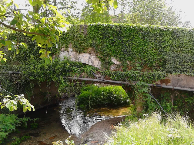
Stone bridge of Painzela on a water line, surrounded by vegetation
Ponte de Painzela, photographed by Tommasoandrea. The image allows observing the arch and the water line; it does not determine the time of construction.© Tommasoandreaⓘ

Calling him Roman doesn't solve your age.

Includes an activity to try →
Read here and view sources

The municipal presentation of Painzela includes a photograph identified as Ponte de Painzela and refers to a Roman Bridge among the heritage of the parish. This designation alone does not demonstrate when the bridge was built. The name allows to find the place; dating would require documentation or study of the construction. It is a good question to lead to a reading of the heritage: what do we know by identification and what we still need to investigate?

See Fact sheet: Ponte de Painzela
Source and context

Municipality — parish presentation of Painzela and bridge identification

Accessed: . Editorial summary; the date of consultation is not the date of the facts.

Cavez · history of the bridge of Moimenta; current conditions not verified

Two seasons on the same bridge

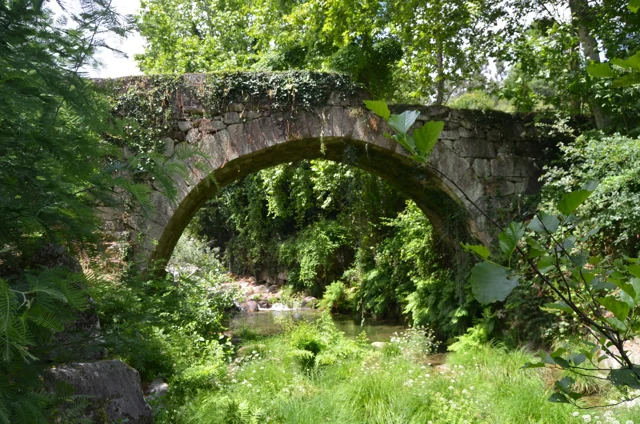
Ponte antiga de Moimenta in Cavez: stone arch over the river, surrounded by vegetation, photographed in June 2020.
Moimenta Bridge, photographed by Pedro at 11 June 2020. A crossing record other than Ponte de Cavez over Tâmega.© Pedroⓘ

In Moimenta, the ancient stone coexists with an intervention of 1990.

Read here and view sources

An ancient bridge can continue to change. The municipality attributes medieval origin to the bridge of Moimenta in Cavez, and describes a single round arch.

In 1990, the passage was extended about one meter: it received a concrete structure on the downstream side and the guards were changed. The photograph allows to begin to observe the crossing; the date of the intervention comes from the documentary description.

Words in this story: see explanations →See Fact sheet: Ponte antiga de Moimenta
Source and context

Municipality — Cultural heritage, bridges of Arco de Baúlhe and Moimenta

Accessed: . Editorial summary; the date of consultation is not the date of the facts.

Bucos · transport in 1758

A small bridge, a long way

Married was in the way of a lot of people.

Includes an activity to try →Explore: Paths that served the life of the village →
Read here and view sources

In Casares, a wooden bridge integrated the real road to Braga and communications with Trás-os-Montes, according to the memory of 1758. Before the movement, the vicar defended building it in stone. It was a request, not the confirmation of a work.

The source distinguishes this passage from small walkways made with a wooden beam, for pedestrians. Different paths responded to different uses.

The passage not only served the village. The vicar describes a public road and very frequented, linking Braga to the term of Basto and Trás-os-Montes. The bridge emerges, as a local point of a larger network. The recommendation to replace it by chanting shows the author to assess a need, besides inventing what existed.

In the same rivers, the water moved mills and was used by farmers in the fields. The crossing, grinding and watering appear in the same portrait of the territory. A bridge can be read by what it allows to do: reach another place, maintain a communication or approximate works separated by water.

Words in this story: see explanations →Getting to know the parish
Source and context

Municipality — Parish memories of Bucos (1758)

Accessed: . Editorial summary; the date of consultation is not the date of the facts.

History of Ponte de Cavez

Five arches, more than a while

Ponte de Cavez on the river Tâmega, with stone arches, board and wooded banks.
Partial view of the Ponte de Cavez over the Tâmega.© Joseolgonⓘ

An old bridge didn't stop in history.

Includes an activity to try →Explore: A crossing, several seasons →
Read here and view sources

Three broken central arches and two perfect back, next to the banks: the Ponte de Cavez brings together different shapes and times. The Museum located the medieval construction in the second half of the 13th century, at the service of the road between Braga and Vila Pouca de Aguiar.

The source attributes the round arches to the works of Philip II's reign and mentions a landmark of 1599. In the 19th century, the road between Fafe and Vila Pouca de Aguiar brought the enlargement of the board. Watching the bridge is looking for changes to an ancient crossing.

According to the Museum, the stone bridge replaced a previous wooden, then degraded. The construction is attributed to Frei Lourenço Mendes, Dominican who gathered alms for the work; the museological text mentions testimonial legacies as support of this connection. The crossing thus involves materials, paths and ways to finance a collective work.

Words in this story: see explanations →See Fact sheet: Ponte de Cavez
Source and context

Land Museum of Basto — Ponte de Cavez, 27/02/2022

Municipality of Cabeceiras de Basto — Parish memories of 1758: Cavez

Municipality — conclusion of rehabilitation of Ponte de Cavez, 30/04/2019

Accessed: . Editorial summary; the date of consultation is not the date of the facts.

Local legend · Ponte de Cavez

The voice that had built above

Ponte de Cavez on the river Tâmega, with stone arches, board and wooded banks.
Ponte de Cavez on the Tâmega · the monument to which legend refers.© Joseolgonⓘ

Around the bridge, memory also invented paths.

Includes an activity to try →
Read here and view sources

The legend published by the Museum makes the masons try to build the bridge in Vila Franca and then by the Poço das Laranjeiras. In both places, a supernatural voice sent up the river. Tradition attributed it to Saint Bartholomew.

On the third attempt, the narrative places the work next to the chapel. It is a story about the memory of the place, not documentary proof of the choice of the site or an itinerary to look for the episodes.

In another passage of the tradition collected by the Museum, the food of the builders gains a miraculous explanation: there are sources of water, wine and olive oil and fish appear in the river. The narrative associates the effort of construction to religious protection. Reading it alongside the history of the works allows to know two different ways of telling the same place.

See Fact sheet: Ponte de Cavez See Fact sheet: Capela de São Bartolomeu de Cavez
Source and context

Land Museum of Basto — Ponte de Cavez, 27/02/2022

Accessed: . Editorial summary; the date of consultation is not the date of the facts.

Arco de Baúlhe e Vila Nune · municipal heritage description

The Triangle Facing Water

A detail of the Old Bridge helps to find out which side the river comes from.

Read here and view sources

At Ponte Velha de Arco de Baúlhe, a semicircular arch holds the board over the Gold River. The municipal description attributes the construction to the 18th century.

The triangular seak is upstream from where the water comes from. This detail allows you to read the bridge beyond its silhouette. The shape of the arch itself does not prove a Roman origin.

Words in this story: see explanations →See Fact sheet: Ponte Velha de Arco de Baúlhe
Source and context

Municipality — Cultural heritage, bridges of Arco de Baúlhe and Moimenta

Accessed: . Editorial summary; the date of consultation is not the date of the facts.

Regional rail link · Celorico bridge Basto

To get to the Arc, the line needed to cross another valley

The history of the Cabeceiras train also passes through the neighboring municipality.

Includes an activity to try →Explore: A bridge ready, an uncompleted connection →
Read here and view sources

Before reaching Cabeceiras, the line had to cross the valley of the river of Veade. The bridge of Matamá is in the Union of the Freguesies of Veade, Gagos and Molares, in Celorico of Basto. According to the Museum, its six granite arches form a structure about 190 meters long and 52 meters high.

The report distinguishes two moments: the opening of the bridge in 5 June 1936, and the entry into railway use in 15 January 1949, with the opening of the Celorico section of Basto–Arco de Baúlhe. Having the bridge built did not immediately mean having trains arriving at the Arc. This regional history helps to realize the time needed to complete the connection.

The report of the Museum attributes the responsibility of the work to engineers Jorge Vieira Bastian and Manuel Gonçalves Costa. The dimension of the structure helps to realize the challenge of taking the railway through the valley; the chronology allows to separate this work from the entry into service of the complete connection.

Source and context

Basto Land Museum / Pedro T. Gonçalves — Matamá Railway Bridge, 28/07/2026

Municipality — Land Museum of Basto: a journey through the history of the region, pp. 28–29

Accessed: . Editorial summary; the date of consultation is not the date of the facts.

Saint Nicholas · testimony of 1758

When the chapel shortened the path

The distance from the church also shaped the villages.

Includes an activity to try →Explore: Three Ways to Approach Places →
Read here and view sources

The memory of 1758 explains the function of three chapels: Saint Bartholomew, in Celeiró do Monte; Our Lady of Lapa, in Lapela; and Saint Anne, in Busteliberne. They served to administer sacraments to the residents who lived far from the matrix. A small building responded to a daily difficulty.

The dean Domingos Camel de Sousa describes high hills between the places and refers three settlements away half league from the church, in rough terrain. The distance was not only a line on the map: relief was part of the difficulty. The church was to spring, in a place with six neighbors, counting the house of the rector himself.

The three chapels were kept at the expense of the commendator, according to the report. But they were not the only ones: the text lists eleven chapels beyond the matrix, with different administrations and functions. In the Outeiro of Santo António, for example, it marks pilgrimages of neighboring parishes in the feasts of Santo António and Santa Luzia. The set reveals both the cult close to the residents and meetings that attracted people from outside.

Words in this story: see explanations →Getting to know the parish See Fact sheet: Busteliberne See Fact sheet: Igreja de São Nicolau de Cabeceiras
Source and context

Basto Land Museum — St Nicholas Parish Memories (1758)

Accessed: . Editorial summary; the date of consultation is not the date of the facts.

Cavez · settlement and devotion in 1758

Eight places and six chapels

In Cavez, an ancient list draws relations between villages, residents and monasteries.

Includes an activity to try →
Read here and view sources

In 25 of May 1758, the vicar Manuel Pacheco da Cunha numbered eight places: Cavez, Vila Franca, Ponte, Arosa, Rabiçais, Moimenta, Revorça and Parada. He located the church in the middle of the parish and described six chapels. Names help to recognize a hammock; they are not a current list of administrative places.

São Gregório, in Vila Franca, São Mamede, in Arosa, and Santa Maria Magdalena, in Moimenta, were attributed to the abbot of Pombeiro, with its maintenance linked to the Benedictine congregation of Tibães. São Bartolomeu, on the Bridge, had as patron João Correia, of Guimarães. In São Caetano, in Raviceis at the passage of the chapels, and Santa Luzia, in Revorça, the charge was for the residents. The transcription itself uses the variants Rabiçais and Raviceais.

The report also describes five altars in the matrix and a brotherhood of the Souls. The parish appears as a space of worship and collective organization, with distinct responsibilities. The pilgrimage of São Bartolomeu is mentioned for 23 and 24 of August; they are dates of historical testimony, without functioning as current agenda.

The parish links went beyond the chapels. The vicar wrote that Cavez did not have their own mail and resorted to Raposeira, which was located to a league. He also indicated the absence of fair in the parish. They are clues to think where news arrived and where services were concentrated at that time; they do not describe the current offer nor allow automatically to convert the league into a road distance.

Getting to know the parish See Fact sheet: Capela de São Bartolomeu de Cavez See Fact sheet: Igreja de São João de Cavez e cruzeiro
Source and context

Municipality of Cabeceiras de Basto — Parish memories of 1758: Cavez

Accessed: . Editorial summary; the date of consultation is not the date of the facts.
YOUR LOCAL GUIDE

What would you like to discover?

Take a closer look.