Discover Cabeceiras de BastoFree independent guide
ViveCabeceirasYOUR GUIDE TO CABECEIRAS
ENEnglish
SearchSaved

Stories of Cabeceiras

Choose a story to start with. You can change the subject or fine tune the search.

24 stories · All themes · Search: granito

Between rivers and mountains

Water and relief form the municipality. Choose a name and follow the landscape.

Choose a story · 11
Geological complex of Cabeceiras de Basto · regional study

Granite also changes grain

A stone of uniform appearance can reveal differences when looking closely.

Includes an activity to try →
Read here and view sources

In the study by A. Almeida, the granite complex of Cabeceiras de Basto does not have a single grain size. The classification uses three average intervals: 0,5–1 millimeter for fine grain, 2–4 millimeters for medium and 5–7 millimeters for coarse grain. In the last group, the author also mentions rare larger crystals, with 8–10 millimeters.

This allows distinguishing two observations: the usual size of the grains and the presence of some crystals that stand out. The description does not transform each visible point of a photograph into a measurement. To compare sizes in an image, a scale is required; a magnification on the screen may make small grains look large.

The study refers to three genetically independent series, although they have similar chemical composition ranges. Appearance is an entrance to research, not all explanation of origin. On a wall or a façade, the grains arouse curiosity, but do not prove for themselves where the stone came from.

Words in this story: see explanations →
Source and context

A. Almeida (1998) — Metallurgical specialisation of the peraluminous granites of two micas of the Cabeceiras de Basto complex, IGM 84(1), B-79–B-82; p. 325 of the PDF

Accessed: . Editorial summary; the date of consultation is not the date of the facts.
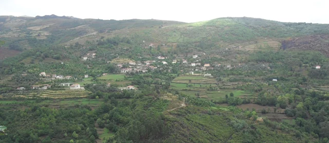
Geology of Vila Nune and Gondiães

Not all the stone is granite

Vila Nune and Gondiães show another part of the geological map.

Explore: The same landscape, different processes →
Read here and view sources

Among the granites, the Archaeological Charter identifies two cores of Paleozoic metasediments. The Vila Nune extends to the northwest, following the alignment of the Peio; the Gondiães flanks the Beça. These are references to understand the diversity of the subsoil, not visiting points or collection sites. The landscape gains another layer when you look at what it is made of.

To understand the name, it is worth separating two stages. Sediments can accumulate, be buried and consolidate into sedimentary rock. If this rock undergoes metamorphism, it undergoes changes caused by conditions such as high temperature and pressure. It is this sedimentary origin followed by transformation that the term metasediment marks.

Metamorphism does not mean melting: USGS explains that the transformation happens without the rock passing the magma. Minerals can reorganize or give way to others. In some rocks, elongated or flattened minerals are oriented and produce a structure in planes, called foliation. Not all metamorphic rocks present it.

They're tools for interpreting the language of the map. They do not allow each stone of Vila Nune or Gondiães to be assigned a mineral, an exact age or a specific process by appearance only. For this, it is necessary to relate the observation with cartography and geological study.

Words in this story: see explanations →
Source and context

Municipality — Archaeological Charter: Orography and geology

British Geological Survey — Rocks and minerals: rock formation, cooling and exposure

U.S. Geological Survey — What are metamorphic rocks?

Accessed: . Editorial summary; the date of consultation is not the date of the facts.
General geology · reading of granite texture

The small grains tell how the rock cooled

Granite holds minerals that can be distinguished by the eye.

Includes an activity to try →
Read here and view sources

The tutor of Adam Mendes, of the Portuguese Association of Professors of Biology and Geology, relates the granular texture of granite to the slow cooling of magma in depth. Among its characteristic minerals are quartz and feldspates; there may also exist mica. This general explanation helps to look at the stone more carefully, but recognizing colors and grains is not enough to identify the origin of a sample.

If granite has formed in depth, how do we see it in an outcrop? The British Geological Survey relates the exposure of these rocks to the survey of land, erosion and change over millions of years. The history of formation and the history of surface exposure are different stages.

It is also convenient to distinguish rock and mineral. In granite, different minerals appear associated in crystals that fit. Recognizing this combination is different from observing a single isolated mineral. The relative sizes of the crystals and their disposition help to describe the texture; an isolated color does not tell the whole story of the rock.

Source and context

Adam Mendes / APPBG — Characterize basalt, gabro, andesite, diorite, riolite and granite; RTP Teach, 2020

British Geological Survey — Rocks and minerals: rock formation, cooling and exposure

Accessed: . Editorial summary; the date of consultation is not the date of the facts.

Geology and relief of the municipality

The mountains is also read in stone

Before the roads and houses, there is a landscape of rocks.

Explore: From rock to field, follow the materials →
Read here and view sources

The Municipal Archaeological Charter describes large granite outcrops with erosion marks. The relief descends from the southern periphery of the Cabreira towards the basin of the Tâmega, in a succession of heads. Looking at these forms helps connect the mountain to the valley: the stone is part of the history of the territory, even when it was not worked by anyone.

A rock can change without leaving the place. It is called meteorization to this change: there can be physical fragmentation, chemical transformation of minerals or intervention of living beings. The British Geological Survey gives simple examples: roots that widen cracks, water that freezes and expands in fractures, or rainwater that reacts with minerals. They are general mechanisms; they do not allow to attribute a cause to every block that is in the Cabreira.

When the materials are removed and transported by water, wind or ice, erosion enters the scene. The distinction helps to imagine two steps: the rock changes; part of its materials can then travel. It is not necessary that the two happen at the same rate, nor that a fragment reaches directly into the river.

The reading tour ends in the veigas of the Tâmega, where the municipal source describes deposits of sand and clay. Between the exposed rock and a lowland field there are thus different questions: of what is made the stone, how is changed and where do the transported materials end?

Words in this story: see explanations →
Source and context

Municipality — Archaeological Charter: Orography and geology

British Geological Survey — Weathering: physical, chemical and biological alteration of rocks

Geological Society — Weathering: difference between change and erosion

Accessed: . Editorial summary; the date of consultation is not the date of the facts.

Geological complex of Cabeceiras de Basto · dating cited in the study

A story with millions of years

The rock age and landscape shape are not the same question.

Explore: Three questions for the same stone →
Read here and view sources

The work of A. Almeida refers to a dating of the complex of Cabeceiras de Basto by the uranium-chumbo method, using the minerals zircon and monazite. The result cited is a minimum age of 311 ± 1 million years. It is a geological reference to the rock formation studied: it does not date the construction of a wall, nor establishes when a hillside has acquired the form that we see today.

The article integrates the minutes of the V National Congress of Geology, published in 1998. Upon reaching the value, Almeida refers to a work of geochronology with other authors, indicated in the bibliography. This chain of references allows us to understand where the number comes from: it is a result of investigation, not an age estimated by the color or size of the grains.

Reading a landscape forces you to separate time scales. One thing is the age attributed to the rocky complex; another, the transformation of relief; another, the moment when a stone was used in a construction. The three stories can cross on the same wall, but need different evidence.

Source and context

A. Almeida (1998) — Metallurgical specialisation of the peraluminous granites of two micas of the Cabeceiras de Basto complex, IGM 84(1), B-79–B-82; p. 325 of the PDF

Accessed: . Editorial summary; the date of consultation is not the date of the facts.

Cabeceiras de Basto · windmill architecture studied in 2011

Above, the grinding; below, the movement

A mill is also organized vertically.

Includes an activity to try →Explore: From the water to the building →
Read here and view sources

The study published by the Museum in 2011 describes two levels in the mills of Cabeceiras: above is the mill; below, in the cabouco, the motor mechanism. The form of the building accompanies the operation of the mill. The survey records rectangular plants of varied dimensions, with the exception of a circular plant sour.

The granite dominates the walls, but not all the stone receives the same treatment. The study highlights the points subject to constructive requirements: corners, doors, windows and elements through which the water passes. In the wedges, the stones help to lock the construction; pads and shoulder pads frame the spans. An irregular wall can thus coexist with carefully chosen pieces.

This description belongs to the historical study, not to an inspection of the current buildings. To read the landscape, start with the route of the water and then ask where were the motor force and the work of grinding.

Words in this story: see explanations →
Source and context

Basto Land Museum — Mills Cabeceiras de Basto: construction form, 04/05/2011

Accessed: . Editorial summary; the date of consultation is not the date of the facts.

Water memory · lifting of 2008

The water had its turn

Sundown to sunset, community rule.

Includes an activity to try →
Read here and view sources

The survey of 4 March 2008 describes the water of Levada de Víbora divided into eleven shifts of 24 hours, called couples. Each shift began at sunset and ended at sunset. The initial order changed from year to year.

The names came from houses of Abadim: six couples were associated with the Village of the Tower and five to Santo António. The granite gutter led water from the stream of Busteliberne for irrigation and grinding. Thus, the levada had a visible construction and an equally important time organization. These data belong to the inventory of 2008, not to a current watering scale.

Source and context

Municipality — inventory of taken, L1 and L18 forms (uplifts of 2008)

Accessed: . Editorial summary; the date of consultation is not the date of the facts.

Ribeira de Cavez · water and agriculture

From the spring to the fields

A stream helps explain the whole landscape.

Read here and view sources

The brook of Cavez is born on the border of the municipality with Montalegre and ends at Tâmega. Between the mountain and the mouth, the municipal description highlights levadas, mills and irrigation mills: buildings and fields that show different ways to enjoy the water.

On the trail beginning in Vilela, Rio Douro, the narrative goes from the descent to the riverside to the levada and the landscape of the lameiros, then following rural paths and the slope. The return to the village brings another material to the history: the granite masonry of the houses. See the route chart to prepare the walk; this reading explains the landscape, without confirming the conditions of the way on the day of the visit.

Getting to know the parish See Fact sheet: Trilho da Ribeira de Cavez See Fact sheet: Vilela, Rio Douro
Source and context

Municipality — stream of Cavez and agricultural landscape

Accessed: . Editorial summary; the date of consultation is not the date of the facts.

Geology and agriculture · lowlands of the municipality

The river also helps explain the fields

Near Tâmega, the ground holds another story.

Includes an activity to try →Explore: Same territory, three looks →
Read here and view sources

In the lowlands near Tâmega, the Archaeological Charter describes accumulations of sand and clay linked to some of the vegetation with the greatest agricultural potential. The contrast is clear: on the slopes dominate large granite outcrops; by the river, deposited materials help explain another way of cultivating. The same presentation shows a landscape of heads that descend south, with water lines that seek the Tâmega and its tributaries. It is not a soil map of each field, but a key to read the set.

Words in this story: see explanations →
Source and context

Municipality — Archaeological Charter: Orography and geology

Accessed: . Editorial summary; the date of consultation is not the date of the facts.

Mineral resources · geological description of the municipality

There's more to the stone than you can see

Volframite and cassitis enter the geological portrait of Cabeceiras.

Read here and view sources

The Municipal Archaeological Charter refers to a geological environment rich in volframite and cassiterite. The two names add a mineral dimension to the landscape of granites and metasediments: they talk about the composition of the subsoil, beyond the form of the hills.

The volframite contains iron, manganese and tungsten. Virtual Microscope, a project with participation from Open University and the Royal Cornwall Museum, explains its importance as tungsten ore. Cassitis is a tin oxide with a formula SnO2, and is an important commercial source of this metal, according to USGS. They're two different minerals, associated with different metals.

A mineral and the metal you can get from it are not the same thing. Volframite is not a piece of metal tungsten, as cassiterite is not ready to use. The interest of these names is precisely in this connection between the matter found in nature and the materials transformed by people.

The municipal description confirms the local geological reference. International sources help explain the minerals, but their examples of exploitation belong to other territories. None of these explanations identify here a visitable mine, an active farm or a collection site.

Words in this story: see explanations →
Source and context

Municipality — Archaeological Charter: Orography and geology

Open University / Royal Cornwall Museum — Virtual Microscope: Wolframite

USGS — Tin Statistics and Information: cassiterite as a tin source

Accessed: . Editorial summary; the date of consultation is not the date of the facts.

Saint Nicholas · hydraulic heritage inventoryed in 2008

A log led the force of the water

In Quinta de Covas, the history of olive oil intersects with that of energy.

Explore: Water changes work →
Read here and view sources

The inventory of 27 of February 2008 located the mill of Quinta de Covas in Parada, in the parish of Cabeceiras de Basto. The water came from a levada with a weir in Peio. Before arriving to the castor, it passed through a gutter excavated in a trunk: wood was also part of this hydraulic construction.

The building brought together an olive oil mill, a mill and a wine mill. The form associates the decommissioning of the mill and the mill in 1994 to the entry into operation of a hydroelectric power station, which conditioned the available motor force. It is the explanation recorded in that survey, not an independent evaluation of the operation of the plant.

The document describes private heritage and equipment already without the necessary elements for grinding. This story does not indicate public access or current conditions of conservation.

Source and context

Municipality — inventory of olive oil mills, record L.A.5, withdrawal of 27/02/2008

Accessed: . Editorial summary; the date of consultation is not the date of the facts.

Crafts and memories

In the hands, at the table and in the community: little stories of how one lives and what one transmits.

Choose a story · 5
Vilela · Rio Douro

The granite also draws the village

Panoramic view of Vilela, Rio Douro, with houses and agricultural plots on the slopes.
Vilela · architecture and landscape of Rio Douro© Ambcruzⓘ

In Vilela, the walls help to recognize the landscape.

Includes an activity to try →
Read here and view sources

The municipal presentation of the Cavez stream trail highlights the granite masonry in the old streets of Vilela, in Rio Douro. After the levadas and the lameiros, the reading of the territory continues in the houses: the material of the region also participates in the form of the settlement.

The municipal text presents a sequence that unites buildings and agricultural work: levadas, mills and lameiros de regádio precede the description of the streets of the village. Vernacular architecture is here the construction linked to the materials and practices of the place. The granite does not appear only as rock of the landscape; it enters the walls and the visual organization of the settlement.

To explore this relationship, it compares Vilela's photograph with reading on granite grains. A view of the village shows volumes and surfaces; a close look at the rock shows another scale. The municipal description does not date each house nor allows to conclude that all the walls have the same history.

Words in this story: see explanations →Getting to know the parish See Fact sheet: Vilela, Rio Douro See Fact sheet: Trilho da Ribeira de Cavez
Source and context

Municipality — stream of Cavez and agricultural landscape

Accessed: . Editorial summary; the date of consultation is not the date of the facts.

Cabeceiras de Basto · hydraulic heritage documented in 2011

The water also had a built path

A levada isn't always a stone-cut channel.

Includes an activity to try →
Read here and view sources

According to the Museum, the levadas lead the water from the dams or from the puddles to the mills. In Cabeceiras, the study describes both granite channels worked as well as streams on firm terrain or dug in the rock. To perceive a mill, it is important to look at the set: building, capture and conduction of the water. It is an explanation of the documented heritage, not an indication of access to the canals.

The materials also tell what has changed. The article of 2011 mentions reconstructions in cement or fiber cement that altered the original configuration of some levadas. Distinguishing the old form of later interventions helps to read this heritage as a history of adaptations, not as a landscape that stood still in time.

Source and context

Basto Land Museum — Mills of Cabeceiras de Basto: water capture and conduction, 07/07/2011

Accessed: . Editorial summary; the date of consultation is not the date of the facts.

Rural heritage · survey of 2008

One water, several jobs

In Eiró, the work of the mill was linked to the irrigation of the fields.

Read here and view sources

The inventory of February 7, 2008 describes the Lagar da Casa da Portelada, in Eiró, Rio Douro, associated with a mill in the same building, with independent entrance. The water of the Levada de Millos served the equipment before going to the irrigation. This successive use connected food processing and agriculture. Private property registration does not confirm current visiting conditions.

The chart situates the old work of the mill in January and February. It also describes the arrival of water on the west side, through a granite structure, and distinguishes the entrance of the mill, to the north, from the entrance of the mill, to the south. They are clues to read the organization of the building. The document contains contradictory indications about the preserved parts; therefore, it does not allow to state that the set was complete or operational.

Source and context

Municipality — Lagares inventory, LA20 fiche, Portelada House (07/02/2008)

Accessed: . Editorial summary; the date of consultation is not the date of the facts.

Rural heritage · survey of 2008

The stones of the road to the mill

A little sidewalk thing tells a work story.

Read here and view sources

In Carrazedo, Bucos, the survey of 11 January 2008 recorded about 30 meters of sidewalk by the cruise, giving access to two mills. The granite slabs had different shapes and sizes. These short roads are also part of the rural heritage: they linked the village to the places where the cereals were transformed. The inventory does not confirm the current status or access. The record of Carrazedo presents the village to which this memory belongs; it does not indicate the exact location of the thirty meters of sidewalk.

See Fact sheet: Carrazedo
Source and context

Municipality — sidewalk inventory, Carrazedo, C5 fiche (11/01/2008)

Accessed: . Editorial summary; the date of consultation is not the date of the facts.

Painzela · mill documented in 2008

The stream had the mill working

The Lord's Lagar turned on water and olive processing.

Explore: From watercourse to processing →
Read here and view sources

In Lagar Velho, in Painzela, the survey of 6 of May 2008 identified the Lagar do Lord as a construction of granite moved by water. A levada of its own led it from the Ribeira do Arejal. The record placed the deactivation in the decade of 1970 and then described the building in ruin, with few elements of grinding. It is documentation about a private property equipment, not a confirmation of the current conditions of visit.

Source and context

Municipality — inventory of mills, Lagar do Senhor (Old), record LA12 (06/05/2008)

Accessed: . Editorial summary; the date of consultation is not the date of the facts.

The flavours of Cabeceiras

From the garden to the pot, from the oven to the table.

Choose a story · 1
Alvite · mill inventory in 2008

From Petimão to olive oil mill

One carried energy to Ramil's house.

Read here and view sources

The municipal survey of 2 of March 2008 describes the mill of Casa do Ramil, in Alvite, fed by Levada do Vale do Moinho, with water removed from the riverside of Petimão. A granite cube led the water to the rotation. The building had two presses and the inventory recorded the deactivation in 2005. This portrait documents the connection between water, construction and transformation of the olive. It is a private property: the historical survey does not confirm public access nor the current state of the equipment.

Compare Covas, in Peio: then the inventory describes a wooden gutter. In both cases, it is important to follow the link between the levada and the mechanism, without imagining that all mills used the same solution.

Source and context

Municipality — inventory of olive oil mills, record L.A.1, withdrawal of 02/03/2008

Accessed: . Editorial summary; the date of consultation is not the date of the facts.

Read the landscape through the plants

Trees, forests, vineyards and fields reveal different ways of occupying the territory.

Choose a story · 2
Sobreira · landscaping documented in 2016

Three cork oaks offer a clue to the name

At Rotunda da Sobreira, plants help tell the story of the place.

Read here and view sources

In June 2016, the municipality announced completion of landscaping at Rotunda da Sobreira, at an entrance to the town. Three cork oaks were planted in the centre and rosemary in the granite beds. The report linked the choice of cork oak to the possible origin of the name Sobreira. This is the source’s interpretation, not a demonstrated etymology. The account documents a landscaping choice in 2016 without confirming each plant’s current condition.

Source and context

Municipality — Urban arrangement of the Sobreira Rotunda, 22/06/2016

Accessed: . Editorial summary; the date of consultation is not the date of the facts.

Local observation · União das freguesias de Gondiães e Vilar de Cunhas · general botany

An oak can keep its dry leaves

Falling in autumn is not a leaf’s only possible fate.

Includes an activity to try →
Read here and view sources

The University of Évora describes Quercus pyrenaica, Pyrenean oak, as having deciduous to marcescent leaves depending on local conditions. On marcescent plants, leaves dry and remain on the branches through the unfavourable season. The book A Vegetação em Portugal highlights this behaviour in young plants of the species. This is a general explanation: it does not automatically identify an oak observed in the municipality.

Other clues complete the portrait: young branches and leaves have a covering of hairs, denser on the underside of leaves. Male flowers appear in catkins; female flowers may occur alone or in small groups. The acorn completes that reproductive cycle.

The profile associates Pyrenean oak with siliceous substrates, including granite and schist, mainly on acidic soils. It also describes differences in leaf behaviour with local moisture conditions. Understanding a tree therefore means combining observations of its crown with its growing environment. One dry leaf attached to a branch reveals neither the tree’s identity nor its state of health on its own.

The photograph by João Lima, recorded on 2025-07-15, shows this species in União das freguesias de Gondiães e Vilar de Cunhas. Open the observation to compare visible details with the botanical description. The record documents that encounter; it does not mean the plant will always be visible in the same place.

Words in this story: see explanations →
Source and context

University of Évora — Virtual Museum of Biodiversity, Quercus pyrenaica

National Press — Vegetation in Portugal, semi-ducifolia and marcescent leaves

iNaturalist — Quercus pyrenaica, João Lima observation in 2025-07-15

Accessed: . Editorial summary; the date of consultation is not the date of the facts.

Time travel

Documents, details and traditions: there is more to discover than a date on a stone.

Choose a story · 5
Abadim · prehistory

The stone also kept drawings

Marmoirals gather ancient tombs and engravings.

Includes an activity to try →
Read here and view sources

In Marmoirais, Abadim, mammoths and granite outcrops with engravings form an archaeological set. The inventory proposes the second or first millennium before Christ, comparing ceramics, engraved motifs and similar sets of the Northwest. Dating results from this interpretation. The name Marmoirais is also related in the source with the tumular memory of the place: the landscape can keep clues in the vestiges and names.

The inventory distinguishes conservation and interpretation: it describes the whole as poorly preserved and admits that the Mamoa 5 can remain intact. It proposes cyst-type funeral structures, without presenting this hypothesis as a confirmed excavation.

The tombs and engravings are different traces, gathered in the same landscape. Reading ceramic materials and comparison with other sets help to propose chronology, but do not automatically reveal the meaning of each recorded motif.

Words in this story: see explanations →Getting to know the parish
Source and context

Municipality — archaeological inventory, interpretations and chronologies

Accessed: . Editorial summary; the date of consultation is not the date of the facts.

Heritage of Abadim

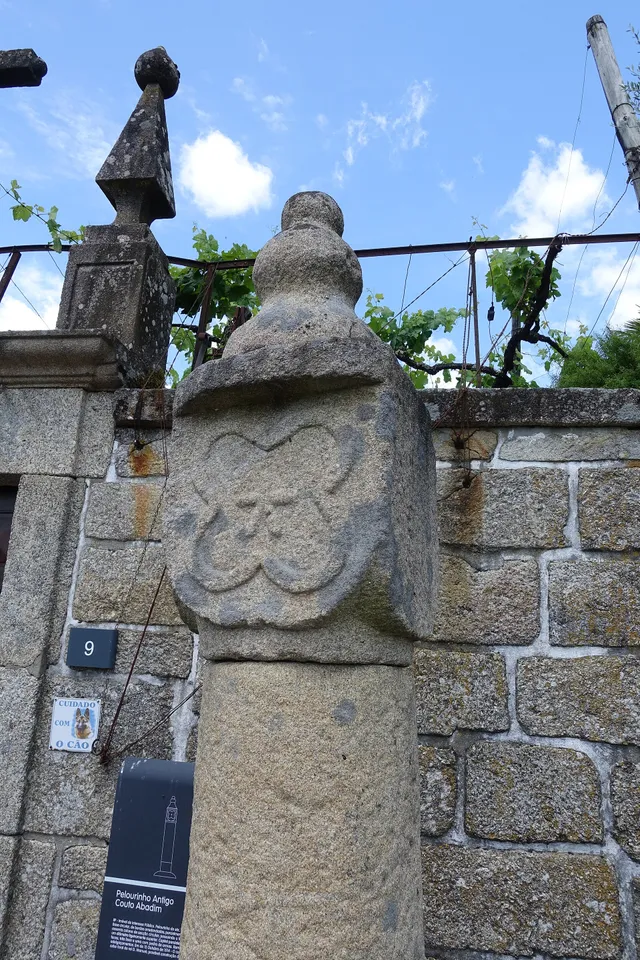
A star in the pillory

Details of the Pelourinho de Abadim in granite
Details of Pelourinho de Abadim. The star described in the text is not visible on this face.© Joseolgonⓘ

A small monument holds a history of autonomy.

Read here and view sources

The pillory of Abadim seems simple at first glance: a smooth column of granite, a cubic capite and a pear-shaped shot. But on one side you find a five-pointed star inside a four-lobe frame. The Museum links the monument to the administrative and judicial autonomy of the former Couto, extinguished in 1836. The Museum brings its construction closer to the foral of 1514, but the record of the Cultural Heritage warns that dating is difficult and that the piece can be quite later. The detail of the star invites you to look again at a piece that would easily go unnoticed.

The official record describes four faces on the capital: three undecorated and one with the star. This helps to understand why a photograph from another side may not show the best known reason. The record places the monument next to the portal of the House of Tower of Tronco and documents the classification as Public Interest Property in 1933. The date of protection is not the date of construction.

The foral, the stone age and the patrimonial classification answer different questions. Instead of automatically assigning ‘1514’ to the entire monument, compare the described form, the proposals for dating and the documents that changed its status.

Words in this story: see explanations →See Fact sheet: Pelourinho de Abadim
Source and context

Basto Land Museum / António P. Dinis — Pelourinho de Abadim, 26/01/2018
Accessed:

Cultural heritage — Pelourinho de Abadim, record 341971, historical-artistic note
Accessed:

Editorial summary; the date of consultation is not the date of the facts.

Regional rail link · Celorico bridge Basto

To get to the Arc, the line needed to cross another valley

The history of the Cabeceiras train also passes through the neighboring municipality.

Includes an activity to try →Explore: A bridge ready, an uncompleted connection →
Read here and view sources

Before reaching Cabeceiras, the line had to cross the valley of the river of Veade. The bridge of Matamá is in the Union of the Freguesies of Veade, Gagos and Molares, in Celorico of Basto. According to the Museum, its six granite arches form a structure about 190 meters long and 52 meters high.

The report distinguishes two moments: the opening of the bridge in 5 June 1936, and the entry into railway use in 15 January 1949, with the opening of the Celorico section of Basto–Arco de Baúlhe. Having the bridge built did not immediately mean having trains arriving at the Arc. This regional history helps to realize the time needed to complete the connection.

The report of the Museum attributes the responsibility of the work to engineers Jorge Vieira Bastian and Manuel Gonçalves Costa. The dimension of the structure helps to realize the challenge of taking the railway through the valley; the chronology allows to separate this work from the entry into service of the complete connection.

Source and context

Basto Land Museum / Pedro T. Gonçalves — Matamá Railway Bridge, 28/07/2026

Municipality — Land Museum of Basto: a journey through the history of the region, pp. 28–29

Accessed: . Editorial summary; the date of consultation is not the date of the facts.

Alvite · heritage and landscape deployment

A chapel leaning against the stone

In Santa Catarina, the construction finds the penedia.

Includes an activity to try →Explore: One chapel, three scales →
Read here and view sources

The municipal presentation highlights a particularity of the chapel of Santa Catarina de Alvite: it is encrusted in a penedia. The encounter between rock and construction gives a clue to look at the heritage beyond the facade.

The source identifies this relationship with the place, but does not provide here a construction date or a visiting time. The chapel form gathers the available documentary information.

The memory of 1758 already named Santa Catarina in the hill with this name, among six chapels of the parish. The two sources answer different questions: the old document places it in a network of places of worship; the municipal presentation draws attention to the relationship between construction and rock. This presence in the report does not date the external form that the photograph shows.

See Fact sheet: Capela de Santa Catarina de Alvite
Source and context

Municipality — landscape of Alvite e Passos

Basto Land Museum — Parish Memories of 1758: Alvite

Accessed: . Editorial summary; the date of consultation is not the date of the facts.

Gondiães · inventory documented assets without current access verification

Three bridges, three passing stories

The name of a bridge doesn't tell you everything about its construction.

Includes an activity to try →
Read here and view sources

The municipal inventory links the Arame Bridge of Padroselos to the tin exploration. The form Po.27 describes iron, wood and ruin, without filling the date of survey.

The Freixo Bridge, no Torneiro, integrated the path between Cunhas and Torneiro. The record Po.28 records granite and no guards. In Po.29, the Arames Bridge over the Beça appears with a concrete board supported by five pillars. These two chips are 20 March 2008.

There are three different references. The inventory allows to know the memory of the connections, but does not confirm current conditions or propose crossings.

Source and context

Municipality — Inventory of bridges, tokens Po.27–Po.29, PDF pages 28–30; Po.28 and Po.29 raised in 20/03/2008, Po.27 without completed date

Accessed: . Editorial summary; the date of consultation is not the date of the facts.

YOUR LOCAL GUIDE

What would you like to discover?

Take a closer look.