Discover Cabeceiras de BastoFree independent guide
ViveCabeceirasYOUR GUIDE TO CABECEIRAS
ENEnglish
SearchSaved

Story

Choose a story to start with. You can change the subject or fine tune the search.

5 stories · Time travel · Search: granito

Time travel

Documents, details and traditions: there is more to discover than a date on a stone.

Choose a story · 5
Abadim · prehistory

The stone also kept drawings

Marmoirals gather ancient tombs and engravings.

Includes an activity to try →
Read here and view sources

In Marmoirais, Abadim, mammoths and granite outcrops with engravings form an archaeological set. The inventory proposes the second or first millennium before Christ, comparing ceramics, engraved motifs and similar sets of the Northwest. Dating results from this interpretation. The name Marmoirais is also related in the source with the tumular memory of the place: the landscape can keep clues in the vestiges and names.

The inventory distinguishes conservation and interpretation: it describes the whole as poorly preserved and admits that the Mamoa 5 can remain intact. It proposes cyst-type funeral structures, without presenting this hypothesis as a confirmed excavation.

The tombs and engravings are different traces, gathered in the same landscape. Reading ceramic materials and comparison with other sets help to propose chronology, but do not automatically reveal the meaning of each recorded motif.

Words in this story: see explanations →Getting to know the parish
Source and context

Municipality — archaeological inventory, interpretations and chronologies

Accessed: . Editorial summary; the date of consultation is not the date of the facts.
Heritage of Abadim

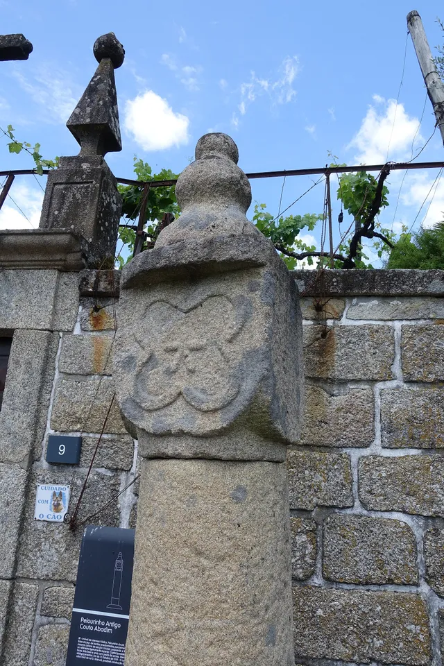
A star in the pillory

Details of the Pelourinho de Abadim in granite
Details of Pelourinho de Abadim. The star described in the text is not visible on this face.© Joseolgonⓘ

A small monument holds a history of autonomy.

Read here and view sources

The pillory of Abadim seems simple at first glance: a smooth column of granite, a cubic capite and a pear-shaped shot. But on one side you find a five-pointed star inside a four-lobe frame. The Museum links the monument to the administrative and judicial autonomy of the former Couto, extinguished in 1836. The Museum brings its construction closer to the foral of 1514, but the record of the Cultural Heritage warns that dating is difficult and that the piece can be quite later. The detail of the star invites you to look again at a piece that would easily go unnoticed.

The official record describes four faces on the capital: three undecorated and one with the star. This helps to understand why a photograph from another side may not show the best known reason. The record places the monument next to the portal of the House of Tower of Tronco and documents the classification as Public Interest Property in 1933. The date of protection is not the date of construction.

The foral, the stone age and the patrimonial classification answer different questions. Instead of automatically assigning ‘1514’ to the entire monument, compare the described form, the proposals for dating and the documents that changed its status.

Words in this story: see explanations →See Fact sheet: Pelourinho de Abadim
Source and context

Basto Land Museum / António P. Dinis — Pelourinho de Abadim, 26/01/2018
Accessed:

Cultural heritage — Pelourinho de Abadim, record 341971, historical-artistic note
Accessed:

Editorial summary; the date of consultation is not the date of the facts.

Regional rail link · Celorico bridge Basto

To get to the Arc, the line needed to cross another valley

The history of the Cabeceiras train also passes through the neighboring municipality.

Includes an activity to try →Explore: A bridge ready, an uncompleted connection →
Read here and view sources

Before reaching Cabeceiras, the line had to cross the valley of the river of Veade. The bridge of Matamá is in the Union of the Freguesies of Veade, Gagos and Molares, in Celorico of Basto. According to the Museum, its six granite arches form a structure about 190 meters long and 52 meters high.

The report distinguishes two moments: the opening of the bridge in 5 June 1936, and the entry into railway use in 15 January 1949, with the opening of the Celorico section of Basto–Arco de Baúlhe. Having the bridge built did not immediately mean having trains arriving at the Arc. This regional history helps to realize the time needed to complete the connection.

The report of the Museum attributes the responsibility of the work to engineers Jorge Vieira Bastian and Manuel Gonçalves Costa. The dimension of the structure helps to realize the challenge of taking the railway through the valley; the chronology allows to separate this work from the entry into service of the complete connection.

Source and context

Basto Land Museum / Pedro T. Gonçalves — Matamá Railway Bridge, 28/07/2026

Municipality — Land Museum of Basto: a journey through the history of the region, pp. 28–29

Accessed: . Editorial summary; the date of consultation is not the date of the facts.

Alvite · heritage and landscape deployment

A chapel leaning against the stone

In Santa Catarina, the construction finds the penedia.

Includes an activity to try →Explore: One chapel, three scales →
Read here and view sources

The municipal presentation highlights a particularity of the chapel of Santa Catarina de Alvite: it is encrusted in a penedia. The encounter between rock and construction gives a clue to look at the heritage beyond the facade.

The source identifies this relationship with the place, but does not provide here a construction date or a visiting time. The chapel form gathers the available documentary information.

The memory of 1758 already named Santa Catarina in the hill with this name, among six chapels of the parish. The two sources answer different questions: the old document places it in a network of places of worship; the municipal presentation draws attention to the relationship between construction and rock. This presence in the report does not date the external form that the photograph shows.

See Fact sheet: Capela de Santa Catarina de Alvite
Source and context

Municipality — landscape of Alvite e Passos

Basto Land Museum — Parish Memories of 1758: Alvite

Accessed: . Editorial summary; the date of consultation is not the date of the facts.

Gondiães · inventory documented assets without current access verification

Three bridges, three passing stories

The name of a bridge doesn't tell you everything about its construction.

Includes an activity to try →
Read here and view sources

The municipal inventory links the Arame Bridge of Padroselos to the tin exploration. The form Po.27 describes iron, wood and ruin, without filling the date of survey.

The Freixo Bridge, no Torneiro, integrated the path between Cunhas and Torneiro. The record Po.28 records granite and no guards. In Po.29, the Arames Bridge over the Beça appears with a concrete board supported by five pillars. These two chips are 20 March 2008.

There are three different references. The inventory allows to know the memory of the connections, but does not confirm current conditions or propose crossings.

Source and context

Municipality — Inventory of bridges, tokens Po.27–Po.29, PDF pages 28–30; Po.28 and Po.29 raised in 20/03/2008, Po.27 without completed date

Accessed: . Editorial summary; the date of consultation is not the date of the facts.

YOUR LOCAL GUIDE

What would you like to discover?

Take a closer look.