Discover Cabeceiras de BastoFree independent guide
ViveCabeceirasYOUR GUIDE TO CABECEIRAS
ENEnglish
SearchSaved

Story

Choose a story to start with. You can change the subject or fine tune the search.

17 stories · Time travel · Search: linha

Time travel

Documents, details and traditions: there is more to discover than a date on a stone.

Choose a story · 17
Arco de Baúlhe e Vila Nune · line memory and path transformation

The line has gained new steps
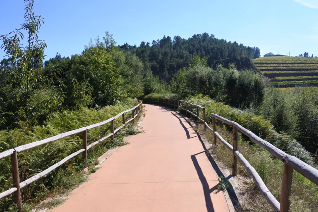
Tâmega Ecopist in Arco de Baúlhe e Vila Nune, with reddish pavement and wooden guards, photographed in October 2016.
The former railway channel converted to Ecopista in Arco de Baúlhe e Vila Nune. Photo by FF Mira, October 6, 2016; does not document the inauguration of 2013 or the current conditions of the entire route.© FF Miraⓘ

The old train path began to receive hikers and bicycles.

Explore: Three Ways to Guard the Railroad →
Read here and view sources

The Tâmega Line channel retained a connecting function after trains. In 20 of April 2013 was inaugurated the section of the Ecopista in the municipality, between the Railway Center of Arco de Baúlhe and Dead Woman, in Vila Nune. The municipal record indicates 5,4 kilometers in this section, within the most extensive link to Amarante.

The relief of the route holds the railway origin: the municipal description relates the old channel with a maximum inclination of 3%. It is a published feature of the layout, not a current check of each entry or obstacle. To prepare an exit, see the practical form and the on-site indications.

The old station and the villager of Vila Nune tell different parts of this story. The municipality identifies the camper among the heritage of Vila Nune; in the Arc, the station passed the museological core. A path can change its use without losing the references that help to recognize its past.

See Fact sheet: Ecopista do Tâmega — troço de Cabeceiras See Fact sheet: Antigo apeadeiro de Vila Nune
Source and context

Municipality — Ecopist of Tâmega: reuse of channel and inauguration of 2013

Municipality — Arco de Baúlhe e Vila Nune: former tenant

Basto Land Museum — Railway Station Arco de Baúlhe classified as Municipal Interest Set, 02/04/2025

Accessed: . Editorial summary; the date of consultation is not the date of the facts.
History of transport · Arco de Baúlhe

One line took forty years to arrive

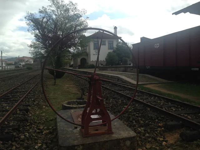
Revolving plate and tracks from the old Arco de Baúlhe station, with buildings and railway equipment at the bottom.
Former station Arco de Baúlhe · railway heritage© JP Ribeiroⓘ

The Arc was the end point of a trip through Tâmega.

Includes an activity to try →
Read here and view sources

The journey began at Livração, where the Line of Tâmega connected to the Douro Line, and ended at Arco de Baúlhe. According to the Municipality, the construction of this narrow track line extended from 1908 to 1949, along about 52 kilometers. The arrival at the Arc was the result of a link built in stages.

The station had functions beyond the shipment of passengers: the old warehouse of dispatches, today used for temporary exhibitions, also recalls the circulation of goods. Visiting the railway core allows you to look for these different lives of the same space: transporting people, receiving cargoes and preserving stories.

Getting to know the parish See Fact sheet: Núcleo Ferroviário de Arco de Baúlhe
Source and context

Municipality — Núcleo Ferroviário de Arco de Baúlhe

Accessed: . Editorial summary; the date of consultation is not the date of the facts.

Regional rail link · Celorico bridge Basto

To get to the Arc, the line needed to cross another valley

The history of the Cabeceiras train also passes through the neighboring municipality.

Includes an activity to try →Explore: A bridge ready, an uncompleted connection →
Read here and view sources

Before reaching Cabeceiras, the line had to cross the valley of the river of Veade. The bridge of Matamá is in the Union of the Freguesies of Veade, Gagos and Molares, in Celorico of Basto. According to the Museum, its six granite arches form a structure about 190 meters long and 52 meters high.

The report distinguishes two moments: the opening of the bridge in 5 June 1936, and the entry into railway use in 15 January 1949, with the opening of the Celorico section of Basto–Arco de Baúlhe. Having the bridge built did not immediately mean having trains arriving at the Arc. This regional history helps to realize the time needed to complete the connection.

The report of the Museum attributes the responsibility of the work to engineers Jorge Vieira Bastian and Manuel Gonçalves Costa. The dimension of the structure helps to realize the challenge of taking the railway through the valley; the chronology allows to separate this work from the entry into service of the complete connection.

Source and context

Basto Land Museum / Pedro T. Gonçalves — Matamá Railway Bridge, 28/07/2026

Municipality — Land Museum of Basto: a journey through the history of the region, pp. 28–29

Accessed: . Editorial summary; the date of consultation is not the date of the facts.

Tâmega · service memory line in 1984

The goods had a marked day

The Tâmega Line also carried goods.

Includes an activity to try →
Read here and view sources

Numa publicação de agosto de 2025, o Museu recorda o serviço de mercadorias que circulava à quarta-feira na Linha do Tâmega, em 1984. Era associado à locomotiva E 165, fabricada pela Henschel & Sohn em 1908. A imagem postal usada pelo Museu foi feita em Celorico de Basto: documenta a linha, não a estação do Arco.

The support is a postcard from the Portuguese Association of Friends of the Iron Paths, dated 1984. There are three times to distinguish: the construction of the machine, the service remembered in the postcard and the publication of the Museum. The document does not describe the load of each trip.

Source and context

Basto Land Museum — The “Modern Market”, 2025-08-27

Accessed: . Editorial summary; the date of consultation is not the date of the facts.

Arco de Baúlhe · railway memories

The train stopped, the memory stayed

Revolving plate and tracks from the old Arco de Baúlhe station, with buildings and railway equipment at the bottom.
Arco de Baúlhe station and railway equipment. Context photography, not of the closing day.© JP Ribeiroⓘ

The station gained another function after closing the line.

Explore: From the last journey to preserved memory →
Read here and view sources

According to the retrospective of the Museum, the Arc station ceased to operate in January 1990, with the closure of the section between Amarante and Arco de Baúlhe. In 8 January 2000, a protocol between REFER and the Municipality opened the way for the provision of facilities and the museological dynamics. The opening of the Museum, in 23 May 2004, belongs to this new life of space.

The compromise brought responsibilities: the Municipality was responsible for preserving, maintaining and managing the section, in collaboration with the National Railway Museum Foundation. The news of the Museum of April 2025 also reports the municipal decision of February 14 of that year to classify the whole. The change of use involved, therefore, agreements and continued work, in addition to the opening of doors to the public.

See Fact sheet: Núcleo Ferroviário de Arco de Baúlhe
Source and context

Basto Land Museum — Railway Station Arco de Baúlhe classified as Municipal Interest Set, 02/04/2025

Accessed: . Editorial summary; the date of consultation is not the date of the facts.

Documented history · 1514

Two outcasts, seven days

October 1514 left two marks on the territory.

Includes an activity to try →Explore: Abadim: documents and marks in place →
Read here and view sources

Manuel I granted the foral of Cabeceiras in 5 October 1514 and that of Vadym, today Abadim, in 12 October. Seven days separate the documents: the administrative history of the territory goes through more than one place.

But what was the point of reviewing the outsiders? The Tombo Tower exhibition explains the general context: there were complaints about outdated charges, coins and weights and old texts difficult to interpret. Manueline reform sought to review these documents. Local dates of 1514 belong to this broader movement; it does not mean that the settlements began to exist that year.

The work also required registration and preservation. The same exhibition describes the preparation in triplicate: one copy for the chamber, one for the landlord of the rights and another for the Tower of the Tombo. This general explanation helps to understand why an administrative document could have several copies. It does not identify here the whereabouts of each copy of the two local forals.

In 5 October 2024, Casa do Tempo received a tertulia over the 510 years of the foral, with José Viriato Chapel and Porfirio Correia. The municipal news recalls the two documents and their importance for the administrative organization. The celebration is a gateway to history; it does not replace the reading of the forals themselves.

Words in this story: see explanations →
Source and context

Municipality — celebration of fora, published in 07/10/2024

DGLAB / Torre do Tombo and Casa de Bragança Foundation — O Foral Novo: records that tell stories, pp. 2 and 4 PDF

Accessed: . Editorial summary; the date of consultation is not the date of the facts.

Alvite · Couto organisation in 1758

One land, two skills

In 1758, not all issues were decided by the same power.

Includes an activity to try →Explore: The territory seen by different rules →
Read here and view sources

The account of St. Pedro of Alvite distinguishes the civil subjects, linked to the Abbot and the convent of Refojos, from the criminals, attributed to the municipality judge of Cabeceiras. The Couto thus had an organization that is not limited to a line on the map. It's a historical description, no correspondence with the current administration. There is an important territorial distinction: the answer places Petimão in the term of Celorico of Basto. The skills of the Couto are described for other places, avoiding reading the entire parish as a single jurisdiction.

Getting to know the parish
Source and context

Basto Land Museum — Parish Memories of 1758: Alvite

Municipality — Alvite Parish Memories, 1758; transcription of José Viriato Chapel (2003)

Accessed: . Editorial summary; the date of consultation is not the date of the facts.

Outeiro · landscape and historical interpretation

The relief gives a clue to the name

A gently wavy landscape on the western shore of the municipality.

Includes an activity to try →Explore: Read Outeiro by three paths →
Read here and view sources

On the western bank of the municipality, next to Fafe, Outeiro is described by the Municipality as a softly wavy relief plateau. The presentation relates the name to this landscape and points to the proximity of the headquarters and the fixing of houses along the road.

The municipal page proposes a medieval interpretation of the names of the places and refers to the scarcity of archaeological data. This formulation needs to be dealt with with the inventory of the PDM published in 2026, which identifies three archaeological sites in Outeiro. The name of the parish still does not itself provide a date of foundation.

Words in this story: see explanations →Getting to know the parish
Source and context

Municipality — Outeiro, relief and hydrographic network

Diary of the Republic — Notice No 16185/2026/2, PDM Cabeceiras de Basto, archaeological inventory AQL34–AQL36, p. 92 (29/06/2026)

Accessed: . Editorial summary; the date of consultation is not the date of the facts.

Bucos · testimony of 1758

A chapel shortened the distance

In Casares, getting to church was a practical matter.

Includes an activity to try →
Read here and view sources

In the memory of 22 May 1758, the chapel of Santa Maria, in Casares, served to administer the sacraments to the residents, far from the parish church. The distance helped explain the distribution of places of worship.

The vicar António Alves Teixeira also mentions Santa Ana, in Carrazedo, administered by Manuel Gomes Martins. They are references of the document, without confirmation of access or current status.

The parish church was located in the place of Bucos, which the vicar presented as the most populous of the parish. In addition, he named Vila Boa, Carrazedo and Casares. This set of places helps to understand why a single church did not respond in the same way to the needs of all residents.

The document also distinguishes who administered each chapel: in Casares, the commander; in Carrazedo, Father Manuel Gomes Martins. Place, invocation and administration are three different clues. The function of administering sacraments because of the distance is explained to Casares; it should not be automatically attributed to all the chapels mentioned.

Getting to know the parish
Source and context

Municipality — Parish memories of Bucos (1758)

Accessed: . Editorial summary; the date of consultation is not the date of the facts.

São Nicolau · 1758 account

When the chapel shortened the path

The distance from the church also shaped the villages.

Includes an activity to try →Explore: Three Ways to Approach Places →
Read here and view sources

The memory of 1758 explains the function of three chapels: Saint Bartholomew, in Celeiró do Monte; Our Lady of Lapa, in Lapela; and Saint Anne, in Busteliberne. They served to administer sacraments to the residents who lived far from the matrix. A small building responded to a daily difficulty.

The dean Domingos Camel de Sousa describes high hills between the places and refers three settlements away half league from the church, in rough terrain. The distance was not only a line on the map: relief was part of the difficulty. The church was to spring, in a place with six neighbors, counting the house of the rector himself.

The three chapels were kept at the expense of the commendator, according to the report. But they were not the only ones: the text lists eleven chapels beyond the matrix, with different administrations and functions. In the Outeiro of Santo António, for example, it marks pilgrimages of neighboring parishes in the feasts of Santo António and Santa Luzia. The set reveals both the cult close to the residents and meetings that attracted people from outside.

Words in this story: see explanations →Getting to know the parish See Fact sheet: Busteliberne See Fact sheet: Igreja de São Nicolau de Cabeceiras
Source and context

Basto Land Museum — St Nicholas Parish Memories (1758)

Accessed: . Editorial summary; the date of consultation is not the date of the facts.

Arco de Baúlhe · railway memories

A gas engine on the rails

The collection counts different ways to get a train moving.

Explore: Who and what was riding the tracks? →
Read here and view sources

The ME5 motor vehicle carried a petrol engine to the rails. The publication on the museum located its construction in the Santa Apolónia workshops in 1948. In the same collection, it describes a steam locomotive manufactured in Germany in 1908.

The dates are forty years and allow comparing two technologies. They are dates of construction of vehicles, not of arrival at the station. The collection gathers pieces from various origins; being in the museum does not show, by itself, where each one circulated.

The Basto Land Museum identifies the engine as Chevrolet and describes the passenger space: 11 first-class seats, 16 third-class and other 16 standing, as well as sanitary facilities. The 27 seating positions shall not be confused with all available positions.

The National Railway Museum explains that a single motor vehicle sought to reduce the costs of operation in lines of low traffic, bringing together functions that required a composition. The project, directed by the engineer Vasco Viana, took advantage of characteristics of road transport. The same record says that the use of gasoline proved costly and led to temporary or extraordinary uses.

The inventory adds a link to the local history: this ME5 will have circulated in the Line of Tâmega. The formulation is prudent and so remains. It is a specific documentary track, different from deducing the circulation just because the vehicle is in the collection today.

Getting to know the parish See Fact sheet: Núcleo Ferroviário de Arco de Baúlhe
Source and context

Municipality — Land Museum of Basto: a journey through the history of the region, pp. 28–29

Basto Land Museum — Heritage with history: Self-propelled ME5, 22/02/2018

National Railway Museum MEf5, FMNF/ARC/ Inventory000203

Accessed: . Editorial summary; the date of consultation is not the date of the facts.

Arco de Baúlhe · railway memories

A place in the third class

A carriage opens a window for the journeys of other times.

Read here and view sources

The Visit Cabeceiras portal highlights a third-class British carriage of 1876 at the Railway Nucleus. The class number and date help to locate the object: it is a 19th-century piece, long before the line arrived at Arco de Baúlhe. The presence in the collection does not mean that it was built for this station.

The municipal publication identifies this piece as Cefv 79 and presents it as the oldest carriage in the collection described there. In the same stall, it refers to a passenger carriage built in Belgium in 1908.

The inventory mark helps distinguish the object; the class refers to its function in passenger transport. The origin of manufacture, service provided and arrival at the museum are separate questions: these sources do not reconstitute all carriage trips.

Getting to know the parish See Fact sheet: Núcleo Ferroviário de Arco de Baúlhe
Source and context

Visit Cabeceiras — Railway core Arco de Baúlhe
Accessed:

Municipality — Land Museum of Basto: a journey through the history of the region, pp. 28–29
Accessed:

Editorial summary; the date of consultation is not the date of the facts.

Alvite · written account from 1758

The earthquake has reached the account of Alvite

A local memory of a larger event.

Includes an activity to try →
Read here and view sources

In reply to the 1758 survey, the vicar of Alvite recalled the earthquake of 1755. He said there had been no ruins, except for the arms of two crosses of the chapel of the House of the Tower, which would have been twisted north. He added that they were already straight.

The report separates the event from the state observed when it was written. It is a local testimony, not a measurement of the intensity of the earthquake nor a confirmation of visible marks today.

Source and context

Municipality — Memory of Alvite, 23/05/1758; transcription of José Viriato Chapel (2003)

Accessed: . Editorial summary; the date of consultation is not the date of the facts.

Pereiras, Refojos · football in the 20th century

When football won the field

The Pereiras are also part of sports memory.

Includes an activity to try →Explore: The Pereiras had several lives →
Read here and view sources

In Pereiras, the memory of the municipality also passes through football. The Basto Land Museum identifies the field inaugurated in 1925 as the first of Cabeceiras de Basto. It served from home to different sports communities, linking the place to the practice of the game and the meetings of those who accompanied it.

In 1982, the construction of the National Road 311 led to the move of the countryside to another location. A sports equipment can thus help count the transformation of a settlement: space changes, but memory preserves the connection to the previous place.

The Museum article, published in July 2024, places the field in a place that had trade, school and fairs. The bibliography includes The Journal of Cabeceiras, of 20 September 1925, and Ecos of Cabeceiras, of 15 August of that year. They are references indicated by the Museum, without reproducing here the contents of these newspapers.

Source and context

Basto Land Museum — The place of the Pereiras of Refojos de Basto, 28/07/2024

Accessed: . Editorial summary; the date of consultation is not the date of the facts.

Line of Tâmega · object presented by the Museum in June 2024

The last light told a story

A red light signaled that the train was going full.

Includes an activity to try →Explore: Two lights, different tasks →
Read here and view sources

The last vehicle of the train carried important information. The Museum features a red-light taillight, used at night in the last carriage or wagon to indicate that the composition was complete. Its function was to signal, not to illuminate the path ahead of the locomotive.

The registration N.1 AND POST. OF THE BOOK connects the object to the station of Livração, in the line of the Valley of Tâmega. Reading the piece implies joining three clues: the color of the light, the position on the train and the inscription associating it to a place.

This small object shows that the railway history is also made of discrete signs and tasks. The presentation of the Museum, published in June 2024, describes the use and station to which the lighthouse was affected; it does not indicate a date of manufacture for the piece.

Words in this story: see explanations →
Source and context

Land Museum of Basto — Taillight “N.1 AND POSTO. FREEDOM”, 2024-06-28

Accessed: . Editorial summary; the date of consultation is not the date of the facts.

Alvite · heritage and landscape deployment

A chapel leaning against the stone

In Santa Catarina, the construction finds the penedia.

Includes an activity to try →Explore: One chapel, three scales →
Read here and view sources

The municipal presentation highlights a particularity of the chapel of Santa Catarina de Alvite: it is encrusted in a penedia. The encounter between rock and construction gives a clue to look at the heritage beyond the facade.

The source identifies this relationship with the place, but does not provide here a construction date or a visiting time. The chapel form gathers the available documentary information.

The memory of 1758 already named Santa Catarina in the hill with this name, among six chapels of the parish. The two sources answer different questions: the old document places it in a network of places of worship; the municipal presentation draws attention to the relationship between construction and rock. This presence in the report does not date the external form that the photograph shows.

See Fact sheet: Capela de Santa Catarina de Alvite
Source and context

Municipality — landscape of Alvite e Passos

Basto Land Museum — Parish Memories of 1758: Alvite

Accessed: . Editorial summary; the date of consultation is not the date of the facts.

Gondiães e Vilar de Cunhas · banknotes published on 1758

Two old portraits, two ways to count

A short note can also open a window to the story.

Includes an activity to try →
Read here and view sources

The municipal transcription of 1758 presents Gondiães with 55 fireworks and 269 souls of communion, together with the matrix dedicated to Saint Martin. Vilar mentions 41 neighbors and 141 sacramental souls, with the church dedicated to St. Lawrence. Both places are located at the end of Cabeceiras de Basto, in the district of Guimarães.

It is important to keep the words of the source: fires or neighbors and souls are not the same category. These numbers should not be added as if they all counted people, nor presented sacrament souls as a modern census of the total population. The text of Gondiães gives the information to Lima; the reference should accompany the reading of these numbers.

Source and context

Municipality — Parish Memoirs of Gondiães (1758), transcript published from José Viriato Chapel (2003)

Municipality — Parish Memoirs of Vilar de Cunhas (1758), reference to José Viriato Chapel (2003)

Accessed: . Editorial summary; the date of consultation is not the date of the facts.

YOUR LOCAL GUIDE

What would you like to discover?

Take a closer look.