Discover Cabeceiras de BastoFree independent guide
ViveCabeceirasYOUR GUIDE TO CABECEIRAS
ENEnglish
SearchSaved
8 STORIES · CONTINUOUS READING

From the mountains to the valley, a landscape with life

Eight stories link relief, forests, forests, fields and seasons. Follows on paper the water flowing to the river and compares the landscape with the changes of the year. It is a guided reading, not a walking itinerary.

All stories in the order of the route. You can print this page by the browser; sources and credits follow the reading.

Things to try8 activities · 6 interactive explorations · 5 questions
Relief of the municipality

From mountains to valley, the map changes height

Look at Cabeceiras from north to south.

The 2025 environmental report places most areas above 800 metres in the north. To the south, beside the Tâmega, land lies below 200 metres. This contrast helps us read the relief: the landscape opens from mountain towards valley. The Archaeological Survey describes the hills as a south-facing amphitheatre. It also links the narrow strips of the northern parishes with their sharing of mountain and valley: the lived territory does not end at a single altitude.

These figures describe parts of the municipality, not two uniform levels. The report characterises the relief as becoming gentler southwards towards the Tâmega. On a walk, a village, a hillside and a valley floor can help us ask questions of the map: where does each place lie, and how does it relate to water?

A difference in altitude is not a walking distance either. Saying two points lie at different heights tells us neither how far we walk between them nor the gradient of the whole route. This story helps interpret the territory; route conditions require their own information.

The dominant direction has exceptions too. The Archaeological Survey highlights waters descending the slopes of Senhora da Orada and entering the Peio. A south-facing landscape therefore does not mean every stream follows a parallel line to the Tâmega. Valleys and tributaries are part of that organisation.

Source and context

Municipality — Environmental Report of the PDM review, February 2025, p. 50

Municipal Archaeological Charter — Orography and geology

Accessed: . Editorial summary; the date of consultation is not the date of the facts.

Back to index ↑
Vegetation described for the area

The forest has a history too

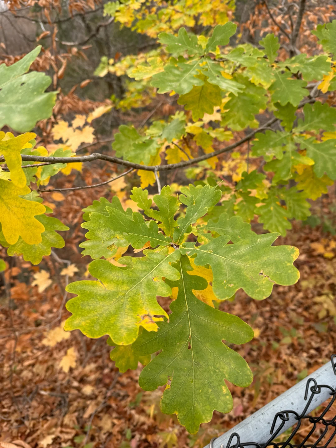
Pedunculate oak leaves, Quercus robur.
Pedunculate oak leaves, Quercus robur.Illustrative photograph
Patrice Dupont
ⓘ

Pedunculate oak leaves, Quercus robur.

Photography: Patrice Dupont · CC BY 4.0

View source

Date given at source: .

Request removal or correct the photo credit

Names that belong to the memory of the mountains.

Oaks and chestnuts form part of the mountain vegetation described by the municipality. The same source describes the partial replacement of that vegetation by maritime pine. A wooded hillside therefore also records planting choices and changes in land use. Looking only at the greenery is not enough: notice the species, the patches and the spaces between trees. This municipal description is not a current survey of every wood.

The same tree species can create different working landscapes. The publication Florestas do Alto Minho distinguishes chestnut orchards, managed for fruit, from chestnut coppices, managed for poles. These are uses of the chestnut tree, not two tree species. This regional comparison helps us ask questions about the landscape of Cabeceiras; it does not identify the purpose of any particular local plot.

There is also a forest beneath the canopy. The understorey consists of plants growing under the trees; dead wood can support wood-feeding insects and fungi too. A forest landscape is therefore more than a count of living trunks. Look for different layers — canopy, low vegetation and fallen wood — without assuming that species mentioned for another region occur in that spot.

Read a tree per part

Open an option and choose the story.

  1. The drawing of a sheet

    Wolves, ribs and petiole are different clues in the description of an oak leaf.

    A leaf drawn in waves →
  2. Inside a chestnut burr

    It follows the relationship between the coating of the fruit and the chestnut we know at the table.

    What is hidden in the hedgehog? →
  3. The scales of a pine cone

    The scales of a pine cone help to find out how to lodge and release seeds.

    A pine cone has small seed houses →
  4. A fruit with a wing

    A winged structure changes the way we look at the fruit; there is local photography to compare.

    A fruit with wing →
  5. Seeds and water

    The alder connects seed dispersion to water and offers another flowering calendar.

    Seeds that travel through water →
Start with the canopy or draw the look of a detail. These clues open stories about trees without replacing the identification of a copy.
Source and context

Municipality — landscape and vegetation

High CIM Minho — High Forests Minho, sours and candlesticks (habitat 9260)

Accessed: . Editorial summary; the date of consultation is not the date of the facts.

Back to index ↑
Common names used in the source

Strawberry tree, carqueja and gorse

Between the trees and fields, another landscape awaits.

Strawberry tree, carqueja, gorse and honeysuckle appear in the municipality’s description of mountain vegetation. The source also links upland scrub to grazing goats, cattle and sheep, distinguishing it from cultivated pasture lower down. Scrub is therefore part of a landscape of plants, animals and work. These common names are starting points for learning about vegetation, not identifications of every plant you encounter.

The municipal account relates this vegetation to changing land use: it mentions the partial replacement of oaks, chestnuts and scrub by maritime pine. Reading the landscape therefore also means asking what was planted and what changed. One green patch may hold stories of grazing, cultivation and forestry.

Start by choosing a detail in the next stories: a carqueja stem, gorse spines, the strawberry tree’s flowers and fruits, or honeysuckle’s place at the woodland edge. Each question brings you closer without requiring you to identify every plant already.

Pick a detail of the bush

Open an option and choose the story.

  1. A stem that also makes photosynthesis

    In the carcass, the reduced leaves invite attention to the green and winged branches.

    In the carqueja, stems also work →
  2. Where do the thorns come from?

    The description of the tojo-arnal explains a transformation of the leaves and refers to winter flowering.

    A forest of well defended branches →
  3. Flowers and fruits at the same time

    The delay in maturation helps explain the meeting of the fruits with the following flowering.

    Flowers and fruits in the same branch →
  4. The encounter between shadow and openness

    The edge of the forest gives context to the habitat described for an example of honeysuckle.

    Madresilva finds room on the edge →
From general portrait to plant structures and cycles.
Source and context

Municipality — landscape and vegetation

Accessed: . Editorial summary; the date of consultation is not the date of the facts.

Back to index ↑
Agricultural landscape

Olive trees, cork oaks and vines

From the hillsides to cultivated river plains.

The municipal description follows the landscape from the hillsides to the river plains: olive trees and cork oaks appear alongside vines trained up other trees. The source mentions poplars, plane trees and fruit trees, including apple, orange and pear trees. It also describes slopes shaped into terraces and small plains beside rivers adapted for farming. This is a way of observing the relationship between relief, water and cultivation, rather than an up-to-date inventory of every plot.

Source and context

Municipality — landscape and vegetation

Municipality — Tourist sites: agricultural landscape and vegetation

Accessed: . Editorial summary; the date of consultation is not the date of the facts.

Back to index ↑
Geology and agriculture · lowlands of the municipality

The river helps explain the fields too

Near the Tâmega, the ground holds another story.

On low ground near the Tâmega, the Archaeological Survey describes accumulations of sand and clay associated with some of the lowland fields offering the greatest farming potential. The contrast is clear: large granite outcrops dominate the slopes; beside the river, deposited materials help explain another way of farming. The same introduction shows hills descending southwards, with waterways seeking the Tâmega and its tributaries. It is not a soil map of each field, but a key to reading the whole landscape.

Same territory, three looks

Open an option and choose the story.

  1. From the mountain to the bottom of the valleyFrom the mountains to the valley, the map changes height →
  2. What water carriesThe river begins before the bank →
  3. How fields are organized on the slopesOlives, cork oaks and vineyards →
It connects the shape of the relief to the transported materials and the cultivation of the slopes.
Source and context

Municipality — Archaeological Charter: Orography and geology

Accessed: . Editorial summary; the date of consultation is not the date of the facts.

Back to index ↑
Council · environmental relations described in the report of 2025

A river begins before its banks

What happens on the land can travel with the water.

Water flowing over the surface can carry soil and nutrients into waterways. The municipal environmental report of February 2025 connects this process with erosion and incorrect use of fertilisers rich in phosphorus and nitrogen. Excessive nutrient enrichment can encourage eutrophication, changing the aquatic environment.

The document also distinguishes groundwater: it notes that excessive use of nitrogen fertilisers can contribute to nitrate accumulation and increased salinity. What happens on the land therefore matters both to the water we see flowing and to water underground.

These are potential pressures described in an environmental assessment. They do not identify a discharge in a particular field or let us assess a river by appearance. To understand the system, connect land, surface runoff and aquifers while keeping general possibilities separate from measurements at a site.

Follow water to the surface and underground

Open an option and choose the story.

  1. The water we don't see on the surfaceUnder the ground there is also water →
  2. The relationship between fields, soil and riverThe river also helps explain the fields →
  3. What can help to study a riverThe life of the river also tells a story →
Three readings to change scale.
Source and context

Municipality — Environmental Report of the PDM review, February 2025, p. 59: land uses and water resources

Accessed: . Editorial summary; the date of consultation is not the date of the facts.

Back to index ↑
Landscape ecology of the municipality

A landscape needs connections

The gaps between green spaces matter too.

An isolated green space does not tell the whole story. The municipal report of 2025 explains that fragmentation reduces and separates habitats, interrupting ecological processes. The ecological network aims to connect natural, agricultural and forest spaces, including gardens, tree-lined avenues and watersides in town. This is a proposal for understanding and planning the territory, not confirmation that all those connections already function.

Choose a part of the landscape

Open an option and choose the story.

  1. In the shadow of the margin

    It explores margin, water and bottom in a scheme that distinguishes environments and relationships.

    The river also has a forest →
  2. Between the trees of the village

    The landscape of the village can also be observed through the shade and trees.

    The shadow is also part of the village →
  3. In the fields by the river

    In the lowlands, deposited materials and fields tell another part of the story.

    The river also helps explain the fields →
  4. At the opening of the woods

    An opening in the vegetation cover allows you to explore different conditions from those within the forest.

    The thimble likes the banks of the forest →
  5. On the edge of the woods

    The transition between forest and adjacent space is a habitat to discover for itself.

    Madresilva finds room on the edge →
It follows from the waterbanks to the gardens and slopes. Each story distinguishes the documented territory from the general characteristics of the species.
Source and context

Municipality — Environmental Report of the PDM review, February 2025, p. 55
Accessed:

Municipality — Environmental Report, February 2025, pp. 50, 55 and 139
Accessed:

Editorial summary; the date of consultation is not the date of the facts.

Back to index ↑
Climate of the municipality · characterization in the report of 2025

The landscape follows a rhythm of rain and warmth

The same place tells different stories throughout the year.

The 2025 environmental report describes colder, wetter winters, with the most rain in December and January, and warmer, drier summers. July and August stand out for their heat. This describes the climate, not the forecast for your next visit. To get to know a place, compare it in different months: water, leaves and flowers can offer new clues.

How is that picture built? The IPMA explains that climatological normals use 30-year periods. They bring together monthly and annual values for elements such as temperature and precipitation. A single month and a decades-long series therefore answer different questions.

When comparing charts, look for the location and reference period: averages calculated over different intervals need not coincide. Long series allow variations and trends to be studied. Observations on a walk help you know that day and place; they do not replace a climate series or, on their own, describe every altitude in the municipality.

The same landscape, different questions

Open an option and choose the story.

  1. How high are we?From the mountains to the valley, the map changes height →
  2. How was the water distributed in summer?In summer, the water took other paths →
  3. What changed in the leaves?A tree, several visits →
  4. Is rain enough for mushrooms?More water is not always better →
It links the weather pattern to the forms of the terrain and the responses of living beings.
Source and context

Municipality — Environmental Report, February 2025, pp. 50, 55 and 139

IPMA — Climate normals: periods and reference values

Accessed: . Editorial summary; the date of consultation is not the date of the facts.

Back to index ↑
YOUR LOCAL GUIDE

What would you like to discover?

Take a closer look.