Discover Cabeceiras de BastoFree independent guide
ViveCabeceirasYOUR GUIDE TO CABECEIRAS
ENEnglish
SearchSaved

Rivers and mountains

Choose a story to start with. You can change the subject or fine tune the search.

13 stories · Between rivers and mountains · Search: 1758

Between rivers and mountains

Water and relief form the municipality. Choose a name and follow the landscape.

Choose a story · 13
Rio Douro · Parish memories of 1758

Two rivers tell a parish’s story

The 1758 account describes Rio Douro between east and west.

Includes an activity to try →Explore: Water linking villages and works →
Read here and view sources

In the 1758 account, the Vilela river flowed to the east and the Rio Douro river to the west, both from north to south. The parish priest described their origins in small springs and their waters increasing with contributions from the mountains. He said the Vilela entered the Tâmega below Cavez bridge and the other joined the river coming from São Nicolau. These are the names and geographical relationships in that document, not a current navigation map.

Bridges bring that geography closer to village life. The document mentions a wooden crossing between Magusteiro and Teixugueiras and a stone one between Teixugueiras and the church. It also refers to wooden links from Eiró and Rio Douro to the church, and a stone one between Vilela and the church. Water and paths therefore appear in the same portrait of the parish.

The priest describes rivers with rocks, weirs and waterfalls, unsuitable for navigation but useful to mills and fields. They were more than lines separating places: they belonged to work and travel. These references come from the testimony signed on 22 May 1758; they do not confirm the survival of structures or present access to the banks.

There is a clue to imagining the relief: the author describes three parallel mountain ridges extending from Salto, with rivers in the lower spaces. The ridges’ names varied between places. Rather than seeking a single name for each mountain line, the document invites us to connect position, villages and the direction of water.

Words in this story: see explanations →Getting to know the parish
Source and context

Municipality of Cabeceiras de Basto — Parish memories of 1758: Rio Douro

Accessed: . Editorial summary; the date of consultation is not the date of the facts.
Cavez · landscape described in 1758

A river that powered mills but did not irrigate

Nearby water was not always accessible water.

Includes an activity to try →
Read here and view sources

In 1758, the Tâmega at Cavez was described as a river with plentiful water throughout the year and a particularly strong winter current. It had weirs, channels and grain mills. Along its banks, the account noted cultivated areas, olive groves and trees supporting vines.

Despite that presence in farming life, the vicar stated that the river did not irrigate the parish’s fields: it ran too deep to allow irrigation channels. This is an important difference between having water nearby and being able to direct it to a plot. The description shows how relief shaped water use at that time; it does not describe present-day irrigation.

Getting to know the parish
Source and context

Municipality of Cabeceiras de Basto — Parish memories of 1758: Cavez

Accessed: . Editorial summary; the date of consultation is not the date of the facts.

Saint Nicholas · rivers in 1758

Bridges put to the winter test

Crossing the river was part of everyday life.

Includes an activity to try →Explore: Cross, sail or water? →
Read here and view sources

The São Nicolau account of 1758 describes three wooden bridges. It says that winter waters sometimes covered the two higher ones and even swept some bridges away. This is historical testimony about floods and routes, not a way to assess the safety of today’s crossings. The document names Sendim, Cerdeiró and Ponte do Gado: these crossings helped connect the church with settlements in the parish.

The description goes beyond the force of floods. It mentions a watercourse with many falls, difficult to ford and, in some stretches, even difficult to follow along its banks. The bridges answered that challenge of the terrain.

The Sendim bridge lay on the route from the church to that settlement; the Cerdeiró bridge served the direction of Breia. Ponte do Gado was lower than the other two and gave its name to the point where the branches from Bucos entered. These details connect paths with waterways without fixing every structure’s position on a modern map.

Getting to know the parish
Source and context

Basto Land Museum — St Nicholas Parish Memories (1758)

Accessed: . Editorial summary; the date of consultation is not the date of the facts.

Passos · relief and water

A mountain and a river to locate Passos

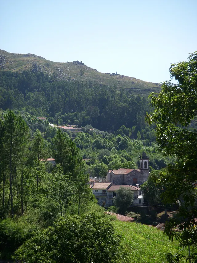
Wooded hillside and houses in the photograph identified by its author as Passos, Cabeceiras de Basto.
Landscape of Passos · slope and house; the river referred to in the text is not identified in the image.© Elisabeth LEITEⓘ

Two names help you read the municipality’s south-west.

Includes an activity to try →Explore: From landscape to work →
Read here and view sources

The Serra da Orada and River Petimão help locate Passos in south-western Cabeceiras. The municipal description highlights rugged terrain and farming, beside the municipalities of Celorico de Basto and Fafe.

The church of São Sebastião, wayside crosses and alminhas shrines add built landmarks to the landscape. River, mountain and heritage offer complementary clues to this place; they do not form a walking itinerary here or confirm access.

In its description of Passos, the municipality also mentions neighbouring former parishes: Outeiro, Refojos and Alvite. This local scale helps place the mountain and river within a shared territory. Administrative boundaries and landscape features are different ways of reading the same space.

Getting to know the parish See Fact sheet: Passos
Source and context

Municipality — landscape of Alvite e Passos

Accessed: . Editorial summary; the date of consultation is not the date of the facts.

Rio Douro · water uses in 1758

In summer, the water took other paths

Irrigation channels linked river flows to work in the fields.

Includes an activity to try →Explore: Water connected jobs and places →
Read here and view sources

The 1758 account describes both Rio Douro rivers flowing all year but reaching the end of their course with little water in summer. The vicar linked this reduction to the many irrigation channels supplying the fields. Weirs, waterfalls and mills formed a landscape of varied work.

Crossings varied too: the account mentions wooden bridges between settlements and the church, as well as stone bridges at Teixugueiras and Vilela. The banks were not just places of production; people needed to cross from one side to the other. This historical list does not identify surviving structures or current access.

The document also explains why boats did not use the rivers: there were rocks, waterfalls and weirs, as well as insufficient flow for navigation. A river could matter to the parish economy without serving as a waterborne transport route.

On cultivated banks, the account mentions oaks supporting vines; beyond the fields, heather scrub. Water therefore helped organise a landscape where cultivation, vegetation and structures met. The response was signed on 22 May 1758: summer is described as a usual seasonal pattern, not a measurement made that summer.

Words in this story: see explanations →Getting to know the parish
Source and context

Municipality of Cabeceiras de Basto — Parish memories of 1758: Rio Douro

Municipality — Parish Memoirs of Rio Douro, António Carneiro da Costa, 22/05/1758

Accessed: . Editorial summary; the date of consultation is not the date of the facts.

Bucos · 1758 account

Two rivers lost their names

Water connected mountains, mills and fields.

Includes an activity to try →Explore: Follows water of Bucos →
Read here and view sources

In 1758, the vicar of Bucos described two watercourses that eventually lost their names on entering the river of São Nicolau. One was Porto Souto, coming from the Serra da Maçã; the other, called the River Moinhos, had origins described in Carrazedo and Figueiró do Monte.

The account brings water and work together: cultivated banks, mills for cereals and water used in farming. It also mentions small wooden footbridges. Reading these elements together helps us imagine connections between fields, crossings and milling. The names and uses belong to the 1758 document; they do not automatically identify watercourses or structures found on the ground today.

Porto Souto is described as flowing all year despite its low volume, with small falls along its north-to-south course. The other watercourse had a calmer current. The vicar records trout and fish called escalos in both: his attention moves from flowing water to fish and then to cultivated banks. A river need not be large for its importance to parish life to become clear.

The text also compares two scales of crossing: the Casares bridge on a busy road and pedestrian crossings made from a single wooden beam. The author stresses the need to improve the former. The river therefore appears linked both to farmers’ daily work and to travel beyond the parish.

Getting to know the parish
Source and context

Municipality — Parish memories of Bucos (1758)

Accessed: . Editorial summary; the date of consultation is not the date of the facts.

Alvite · 1758 account

Storing water from the hillside

Small springs helped irrigate the fields.

Includes an activity to try →
Read here and view sources

In the 1758 account, the vicar of Alvite described small springs in the Serra da Orada. Residents held this water in pools to benefit east-facing fields. Storing water was a way of dealing with scarcity.

The same document described the parish as dry, particularly in summer, and noted the absence of grain mills and fulling mills. Two olive-oil mills worked with oxen and other animals; to grind cereals, many residents went to neighbouring parishes. The account links natural resources, techniques and journeys without establishing that the same uses or structures survive today.

Getting to know the parish
Source and context

Basto Land Museum — Parish Memories of 1758: Alvite

Accessed: . Editorial summary; the date of consultation is not the date of the facts.

São Nicolau · 1758 account

Water irrigated fields and made olive oil

One river, different kinds of work.

Read here and view sources

In 1758, the parish priest of São Nicolau described irrigation channels serving fields and water powering an olive-oil mill at Quinta da Taipa. One channel served Gondarém, Frágua, Penedo and Lamelas. The account helps us imagine the link between river, irrigation and production. It distinguishes three continuous channels: one for those settlements and two for the estates of Bouças and Taipa. It also mentions mills supplied by weirs.

The description includes a smaller watercourse to the west, originating in springs on the hills of Lapela and Celeiró. On this river, the rector mentions mills and a channel serving the fields of Casal. He recalls two others intended for Quinta da Taipa, one of them ruined. The water-use network therefore included structures in use and others that no longer worked as before.

This detail helps us understand water-powered heritage as ongoing work: a channel’s existence in an old account does not guarantee its use in another period. The source also distinguishes settlements’ shared uses from estate channels, allowing comparison of different relationships between water, fields and owners.

Getting to know the parish
Source and context

Basto Land Museum — St Nicholas Parish Memories (1758)

Accessed: . Editorial summary; the date of consultation is not the date of the facts.

Santa Senhorinha · 1758 account

The river became part of farming life

A cultivated riverbank tells history too.

Includes an activity to try →Explore: One river, four stories →
Read here and view sources

The 1758 account describes the river of Santa Senhorinha flowing all year, but with little water in summer. It describes cultivated banks, fruit trees and wild trees, linking water with irrigation and rural work.

Vila de Lobos and Cainhos had olive-oil mills; grain mills are mentioned in Vila de Lobos and Sestelo. The same description follows several river uses: growing crops, grinding grain and processing olives. It does not confirm which facilities survive or operate today.

Unlike the rushing currents described at São Nicolau, the abbot characterises this river as calm and flowing from west to east. He begins its course at Aboim and lists Várzea Cova, Passos and São Clemente before Santa Senhorinha. This is the geography reported in the document, not a current delineation of the watercourse.

Residents’ use of water for the fields is described as unrestricted. The account was signed on 23 May 1758. That detail matters: the reference to little water in summer describes a pattern known to the author, not an observation made during that year’s summer.

Words in this story: see explanations →
Source and context

Municipality — Memória de Santa Senhorinha, 23/05/1758; transcript of José Viriato Chapel (2003)

Accessed: . Editorial summary; the date of consultation is not the date of the facts.

St Nicholas and Painzela · hydrography in the testimony of 1758

Two rivers meet at Ranha

A document lets us follow water between parishes.

Explore: Follow water in document →
Read here and view sources

The 1758 São Nicolau account places the meeting of the river crossing the parish with the one from Painzela at Ponte da Ranha. It then describes their combined flow heading towards the Tâmega near Cavez bridge. This is a historical reading of the water network connecting the territory, not a suggested riverside walk.

Before that meeting, the priest follows São Nicolau’s river from the hill called Víbora. He describes a modest spring receiving other streams, its flow strengthened at Ponte do Gado by two branches from Bucos. He mentions water throughout the year and a particularly strong winter flow.

The text also follows changes of direction: south, then east, then south again. It tells the landscape through the movement of water. Springs, tributaries and confluence explain different stages; the author’s names belong to the testimony signed on 22 May 1758.

Notice the sequence of meetings: the Bucos branches first strengthen São Nicolau’s flow; water from Painzela joins at Ranha; their shared destination is the Tâmega. Drawing these junctions helps distinguish a river’s course from the network of contributions feeding it.

Words in this story: see explanations →
Source and context

Basto Land Museum — St Nicholas Parish Memories (1758)

Accessed: . Editorial summary; the date of consultation is not the date of the facts.

Saint Nicholas and Painzela · testimony of 1758

A bridge for loaded carts

Three springs and a crossing connected two parishes.

Includes an activity to try →Explore: Pass, water and grind →
Read here and view sources

In 1758, the parish priest describes a small river rising from three springs on the hills of Lapela and Celeiró. It entered Painzela through Vilarinho, where a wooden bridge supported loaded carts. The testimony does not identify a crossing that can be visited today.

The same river also powered mills and supplied an irrigation channel for the fields of Casal. The author recalls two other diversions linked to the Taipa estate, one already ruined when the account was written.

This description brings together transport, milling and irrigation. A bridge allowed crossing; a channel diverted some water to another use. Their functions were not equivalent, although they belonged to the same working landscape. The reference to a ruined structure also shows that the document records changes and losses alongside what was working.

Words in this story: see explanations →
Source and context

Basto Land Museum — St Nicholas Parish Memories, 22 May 1758

Accessed: . Editorial summary; the date of consultation is not the date of the facts.

Saint Nicholas · environmental history of 1758

Fish that entered the written record

An old document also describes life in the rivers.

Includes an activity to try →Explore: Three Ways to Know a River →
Read here and view sources

The São Nicolau account lists trout and fish called bogas and escalos in the main river, in small numbers. In the smaller watercourse, it mentions small trout. These are names used in the 1758 document, not scientific identifications or confirmation of present populations.

Domingos Camelo de Sousa distinguishes the watercourses before discussing fish. The main one received two branches from Bucos near Ponte do Gado; the smaller one rose in springs on the hills of Lapela and Celeiró and continued to Painzela. This location gives context to the animal names. The account also comments on the fishes’ taste, revealing a view connected with food rather than the method of a biological survey.

Source and context

Basto Land Museum — St Nicholas Parish Memories, 22 May 1758

Accessed: . Editorial summary; the date of consultation is not the date of the facts.

Abadim · water and grinding in memory 1758

Two streams kept six mills working

Even a little water could keep a landscape moving.

Includes an activity to try →Explore: From water to food →
Read here and view sources

In 1758, the abbot of Abadim describes two streams descending southwards, meeting near Ponte de Pé and continuing to the Tâmega. There was little water, but it flowed all year. The account mentions trout and fish called bogas without identifying species by scientific names.

On the western stream, he notes Ranha’s dressed-stone bridge. Of the various mills on the two waterways, six belonged to the parish. This count identifies neither today’s buildings nor whether they were the same mills as the group now called Moinhos de Rei.

The abbot describes swift currents and neighbouring communities’ free use of the water. Little water and movement were therefore not incompatible in his account. The story gains another dimension beside the fields: the same document distinguishes cereals grown in different settlements. The streams belonged to a landscape of cultivation and processing, although the account does not say which mill received each village’s grain.

Words in this story: see explanations →
Source and context

Municipality — Parish memories of Abadim, José Antunes, 22/05/1758

Accessed: . Editorial summary; the date of consultation is not the date of the facts.

YOUR LOCAL GUIDE

What would you like to discover?

Take a closer look.