Discover Cabeceiras de BastoFree independent guide
ViveCabeceirasYOUR GUIDE TO CABECEIRAS
ENEnglish
SearchSaved
9 STORIES · CONTINUOUS READING

Abadim: marks on the landscape

Nine stories to connect the mountains, fields and water to the marks of local power. Observes tower and pillory, compares the administration of 1758 and discovers two dates in Casa da Ramada. It is a reading route without indicating a walk or access to the buildings.

All stories in the order of the route. You can print this page by the browser; sources and credits follow the reading.

Things to try5 activities · 2 interactive explorations · 6 questions
Toasters · Abadim

A village above a thousand metres
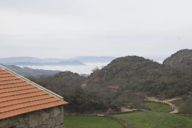
Landscape at Trilho de Torrinheiras.
Landscape of Trilho de Torrinheiras© Ze Nunoⓘ

In Torrinheiras, the landscape begins at altitude.

The municipality presents Torrinheiras, in Abadim, as its highest settlement, at around 1020 metres. The trail climbs into the hills and reaches 1159 metres. These are two distinct altitude references: the village and a point on the route, not the walk’s cumulative ascent.

The panorama description names Gerês, Alvão, Marão and Barroso. Lower down, it mentions the Busteliberne stream, Porto d’Olho and, on the return, meadows and grazing Barrosã and Maronesa cattle. The mountains therefore tell a story of distances and views, but also of water, villages and work. Visibility and trail conditions need to be assessed when visiting.

The mountain can also be read close up. Alongside the distant panorama, the description mentions meadows and livestock: clues to land use, not merely decorative details. In a drawing, separate the horizon from the worked land. A simple next question is: which parts of this landscape depend on people’s work?

Getting to know the parish See Fact sheet: Trilho de Torrinheiras
Source and context

Municipality — Trilho de Torrinheiras, altitude, landmarks and landscape

Accessed: . Editorial summary; the date of consultation is not the date of the facts.

Back to index ↑
Abadim · agriculture described in 1758

Within one parish, the harvest changed

In 1758, the cold separated two farming landscapes.

In Abadim’s account, José Antunes distinguishes the fields of Aldeia da Torre and Santo António from those of Travassô, Porto d’Olho and Torrinheiras. For the first two places he lists maize, painço and rye, as well as wine, olive oil, chestnuts and oak acorns.

In the three places he describes as colder, he highlights rye and little maize. The document brings climate, terrain and food together: harvests were not the same across the parish. It gives no crop weights and does not allow production per resident to be calculated.

The author also places Torrinheiras on top of the hill and Porto d’Olho and Travassô halfway up the slope. His description helps connect names with positions in the landscape without giving measured elevations. On the hills he mentions heather, carqueja, gorse and some grazing. The agricultural picture therefore includes crops and scrubland: the parish does not appear as one uniform field.

Source and context

Municipality — Parish memories of Abadim, José Antunes, 22/05/1758

Accessed: . Editorial summary; the date of consultation is not the date of the facts.

Back to index ↑
Abadim · ancient settlement

From settlement to farmstead

Rome also changed how land was occupied.

With Romanisation, the Archaeological Map describes changes in population distribution between mountains and valleys and the agricultural occupation of lower land. In Abadim, it mentions an open farmstead-type settlement. The text suggests that people connected with the honorific inscriptions it mentions may have lived there. The settlement’s existence and the proposed identity of its inhabitants do not carry the same degree of certainty: the latter remains a hypothesis.

Getting to know the parish
Source and context

Archaeological Letter of Cabeceiras de Basto — Protohistory and Romanization

Accessed: . Editorial summary; the date of consultation is not the date of the facts.

Back to index ↑
Abadim · prehistory

Stone preserved drawings too

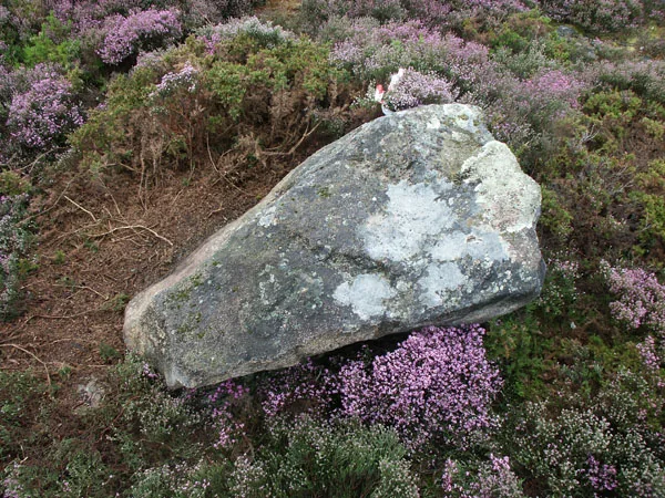
Engraved rock in the Marmoirais complex.
ⓘ

Engraved rock in the Marmoirais complex.

Source: Carta Arqueológica de Cabeceiras de Basto

View source

Photograph date not stated.

Autoria da fotografia e licença de reutilização não identificadas na fonte.

Request removal or correct the photo credit

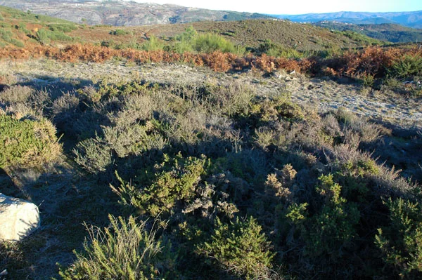
Area of the Marmoirais burial mounds.
ⓘ

Area of the Marmoirais burial mounds.

Source: Carta Arqueológica de Cabeceiras de Basto

View source

Photograph date not stated.

Autoria da fotografia e licença de reutilização não identificadas na fonte.

Request removal or correct the photo credit

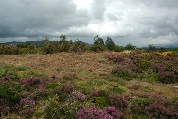
Area of the Marmoirais burial mounds.
ⓘ

Area of the Marmoirais burial mounds.

Source: Carta Arqueológica de Cabeceiras de Basto

View source

Photograph date not stated.

Autoria da fotografia e licença de reutilização não identificadas na fonte.

Request removal or correct the photo credit

Marmoirais brings together ancient tombs and engravings.

At Marmoirais in Abadim, burial mounds and engraved granite outcrops form an archaeological group. The inventory proposes the second or first millennium BC, comparing pottery, engraved motifs and similar groups in the north-west. The dating results from that interpretation. The source also connects the name Marmoirais with the place’s burial memory: a landscape can hold clues in both remains and names.

The inventory distinguishes preservation from interpretation: it describes the group as poorly preserved and allows that Mamoa 5 may remain intact. It proposes cist-type burial structures without presenting that hypothesis as confirmed by excavation.

Tombs and engravings are different remains sharing one landscape. Reading pottery and comparing other groups help suggest a chronology, but do not automatically reveal the meaning of each engraved motif.

Getting to know the parish Ver ficha: Marmoirais — necrópole e arte rupestre
Source and context

Municipality — archaeological inventory, interpretations and chronologies
Accessed:

Carta Arqueológica de Cabeceiras de Basto — 01.08
Accessed:

Carta Arqueológica de Cabeceiras de Basto — 01.09
Accessed:

Editorial summary; the date of consultation is not the date of the facts.

Back to index ↑
Abadim · water and grinding in memory 1758

Two streams kept six mills working

Even a little water could keep a landscape moving.

In 1758, the abbot of Abadim describes two streams descending southwards, meeting near Ponte de Pé and continuing to the Tâmega. There was little water, but it flowed all year. The account mentions trout and fish called bogas without identifying species by scientific names.

On the western stream, he notes Ranha’s dressed-stone bridge. Of the various mills on the two waterways, six belonged to the parish. This count identifies neither today’s buildings nor whether they were the same mills as the group now called Moinhos de Rei.

The abbot describes swift currents and neighbouring communities’ free use of the water. Little water and movement were therefore not incompatible in his account. The story gains another dimension beside the fields: the same document distinguishes cereals grown in different settlements. The streams belonged to a landscape of cultivation and processing, although the account does not say which mill received each village’s grain.

From water to food

Open an option and choose the story.

  1. To know the grain of the fieldsIn the same parish, the harvest changed →
  2. Realizing how water was distributedThe water had its turn →
  3. Discover the bread cycleBefore the bread, there was a field →
It follows three links between landscape and work, respecting the time of each document.
Source and context

Municipality — Parish memories of Abadim, José Antunes, 22/05/1758

Accessed: . Editorial summary; the date of consultation is not the date of the facts.

Back to index ↑
Abadim · milling history

Flour brought revenue to the king too

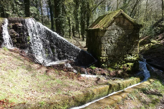
Granite mill supplied by the Levada de Víbora at Moinhos de Rei, with a waterfall and channel in wooded surroundings. Photograph from 2025.
Moinhos de Rei · the place of grinding© Joseolgonⓘ

Moinhos de Rei preserves a story of water, grain and income.

In the historical narrative published by the municipality, these communal mills belonged to the Crown and half their income was assigned to the king. The same description mentions a later change to a symbolic tax. The place name thus opens a window onto the economic organisation of milling.

The income mentioned concerns the mill’s economic activity. Without more information, it should not be converted into a rule that each person handed half a sack of grain to the king. The introduction gives no accounts, quantities ground or date for the change to a symbolic tax.

Exploring the history of Moinhos de Rei, you can ask two different questions: how did water reach the machinery, and how were the benefits of milling distributed? The levada helps follow the first; the reference to the Crown opens the second. Technology, organisation and income belong to the same working landscape.

See Fact sheet: Moinhos de Rei
Source and context

Municipality — Moinhos de Rei, historical account of milling and the Crown

Accessed: . Editorial summary; the date of consultation is not the date of the facts.

Back to index ↑
Abadim’s heritage

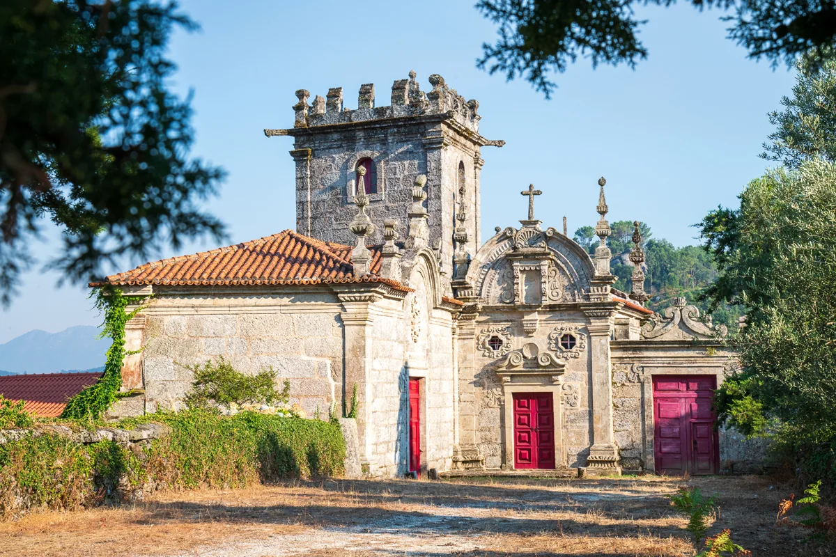
A tower worth looking at slowly

Abadim tower and adjoining buildings.
ⓘ

Abadim tower and adjoining buildings.

Source: Visit Cabeceiras — Município de Cabeceiras de Basto

View source

Photograph date not stated.

Individual photographer and reuse licence not stated by the source.

Request removal or correct the photo credit

History can be read in windows and corners too.

Abadim’s tower has battlements at the top and animal-shaped gargoyles at the corners. António P. Dinis highlights the arrow slit, pointed-arch doorways and, inside, window seats. He proposes a 16th-century construction, perhaps from the charter’s period, without fixing an exact date.

The 1758 account places the tower in the middle of Aldeia da Torre and says it suffered no ruin in the 1755 earthquake. The same document describes Abadim with an ordinary judge and council, within the old couto’s own organisation. Reading architecture and administration together helps explain the building’s importance; the interior description does not confirm present access.

António P. Dinis’s text distinguishes the likely site of the medieval manor from the 16th-century building described today. They are not necessarily the same building preserved unchanged. The name Casa do Tronco accompanies the hypothesis that the couto’s court and prison operated here.

In the 1758 account, the donatary presided over the election of the ordinary judge and council. The document also mentions intervention by the corregedor of Guimarães during inspections or a new judicial commission. Having local institutions should therefore not be confused with administration unconnected to other authorities.

Read the marks of power and time

Open an option and choose the story.

  1. The symbol and doubt about your ageA star in the pillory →
  2. The document of 1514Two forals, seven days →
  3. Two dates on the doors of a houseTwo dates do not tell the whole house →
  4. Other local organisation in 1758One land, two skills →
Each reading distinguishes what is described, the date of the document and the interpretation hypotheses.
See Fact sheet: Torre de Abadim / Casa do Tronco
Source and context

Basto Land Museum / António P. Dinis — Tower of Abadim, 17/01/2018

Municipality — Parish memories of Abadim, José Antunes, 22/05/1758

Accessed: . Editorial summary; the date of consultation is not the date of the facts.

Back to index ↑
Abadim’s heritage

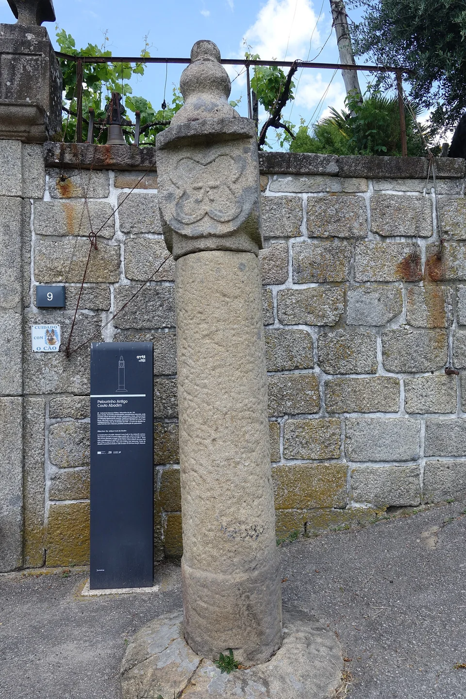
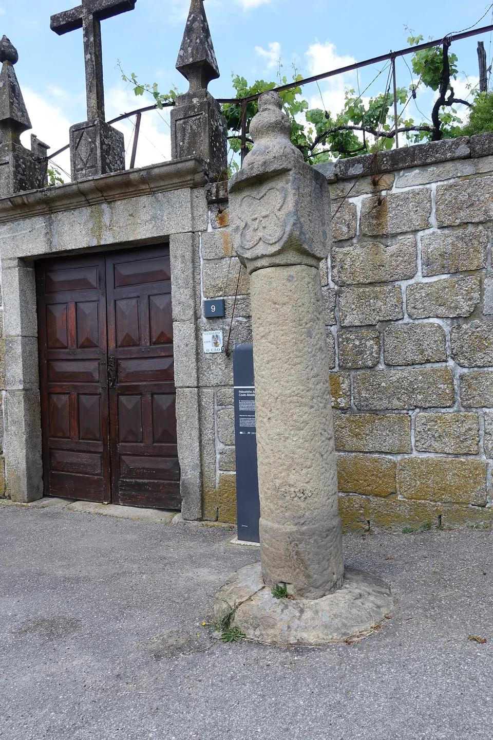
A star on the pillory

Abadim pillory, with a building and wall in the background.
Joseolgon
ⓘ

Abadim pillory, with a building and wall in the background.

Photography: Joseolgon · CC BY-SA 4.0

View source

Date given at source: .

Request removal or correct the photo credit

Detail of the column and finial of Abadim pillory.
Joseolgon
ⓘ

Detail of the column and finial of Abadim pillory.

Photography: Joseolgon · CC BY-SA 4.0

View source

Date given at source: .

Request removal or correct the photo credit

A small monument holds a history of autonomy.

Abadim’s pillory looks simple at first: a smooth granite column, a cubic capital and a pear-shaped finial. Yet one face bears a five-pointed star within a four-lobed frame. The Museum connects the monument with the administrative and judicial autonomy of the old couto, abolished in 1836. It places construction near the charter of 1514, but the Cultural Heritage record warns that dating is difficult and the piece may be much later. The star invites a second look at a monument easily overlooked.

The official record describes four faces on the capital: three undecorated and one bearing the star. This explains why a photograph from another side may not show its best-known motif. The record places the monument beside the portal of Casa da Torre do Tronco and documents its designation as a Property of Public Interest in 1933. The protection date is not the construction date.

The charter, the stone’s age and the heritage designation answer distinct questions. Instead of automatically assigning “1514” to the entire monument, compare its described form, proposed dates and the documents that changed its status.

See Fact sheet: Pelourinho de Abadim
Source and context

Basto Land Museum / António P. Dinis — Pelourinho de Abadim, 26/01/2018
Accessed:

Cultural heritage — Pelourinho de Abadim, record 341971, historical-artistic note
Accessed:

Editorial summary; the date of consultation is not the date of the facts.

Back to index ↑
Abadim · architecture and interpreting inscriptions

Two dates do not tell a house’s whole story

At Casa da Ramada, doors preserve clues from different periods.

In Abadim, António P. Dinis highlights Casa da Ramada, with its armorial gateway, granary, threshing floor and porch. He records 1678 on one lintel and 1828 on another doorway’s lintel. From these marks, he proposes an initial 17th-century structure and improvements in the first half of the 19th century.

An inscription is a clue, not a birth certificate for every wall. The two dates suggest a house that changed over time: living and working spaces may combine elements from several periods. The source does not confirm current access arrangements.

Getting to know the parish
Source and context

Basto Land Museum / António P. Dinis — Tower of Abadim, 17/01/2018

Accessed: . Editorial summary; the date of consultation is not the date of the facts.

Back to index ↑
YOUR LOCAL GUIDE

What would you like to discover?

Take a closer look.