Discover Cabeceiras de BastoFree independent guide
ViveCabeceirasYOUR GUIDE TO CABECEIRAS
ENEnglish
SearchSaved

Traditions

Choose a story to start with. You can change the subject or fine tune the search.

5 stories · Crafts and memories · Search: granito

Crafts and memories

Through hands, food and community: small stories of how people lived and what they pass on.

Choose a story · 5
Vilela · Rio Douro

Granite shapes the village too
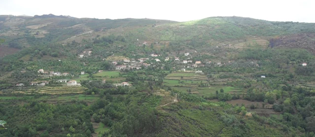
Panoramic view of Vilela, Rio Douro, with houses and agricultural plots on the slopes.
Vilela · architecture and landscape of Rio Douro© Ambcruzⓘ

In Vilela, the walls help you recognise the landscape.

Includes an activity to try →
Read here and view sources

The municipal introduction to the Cavez stream trail highlights granite masonry in the old streets of Vilela, in Rio Douro. After irrigation channels and meadows, the reading of the territory continues through its houses: the region’s material also helps shape the settlement.

The municipal text presents a sequence linking buildings with farming: channels, mills and irrigated meadows precede the description of the village streets. Vernacular architecture here means building connected with local materials and practices. Granite is not only a rock in the landscape; it enters the walls and the settlement’s visual character.

To explore this relationship, compare the photograph of Vilela with the reading about granite’s grains. A village view shows volumes and surfaces; a close look at the rock reveals another scale. The municipal description neither dates each house nor allows us to conclude that every wall has the same history.

Words in this story: see explanations →Getting to know the parish See Fact sheet: Vilela, Rio Douro See Fact sheet: Trilho da Ribeira de Cavez
Source and context

Municipality — stream of Cavez and agricultural landscape

Accessed: . Editorial summary; the date of consultation is not the date of the facts.

Cabeceiras de Basto · water heritage documented in 2011

Water had a built route too

A levada is not always a dressed-stone channel.

Includes an activity to try →
Read here and view sources

According to the Museum, levadas carry water from weirs or pools to mills. In Cabeceiras, the study describes both channels made from worked granite and channels in firm ground or cut into rock. Understanding a mill means looking at the whole: the building, water intake and water supply. This explains documented heritage; it does not indicate access to the channels.

Materials also reveal change. The 2011 article mentions rebuilding in cement or fibre cement that altered the original form of some levadas. Distinguishing earlier forms from later interventions helps us read this heritage as a history of adaptation, not a landscape frozen in time.

Source and context

Basto Land Museum — Mills of Cabeceiras de Basto: water capture and conduction, 07/07/2011

Accessed: . Editorial summary; the date of consultation is not the date of the facts.

Rural heritage · 2008 survey

One water supply, several tasks

In Eiró, the oil mill connected with field irrigation.

Read here and view sources

The inventory of 7 February 2008 describes the olive-oil mill at Casa da Portelada in Eiró, Rio Douro, alongside a grain mill in the same building with a separate entrance. Water from the Levada de Moinhos powered the equipment before continuing to irrigate fields. This successive use connected food processing with farming. The record of private property does not confirm current visiting arrangements.

The record places the oil mill’s former working season in January and February. It also describes water arriving from the west through a granite structure, and distinguishes the grain mill’s northern entrance from the oil mill’s southern entrance. These are clues to the building’s arrangement. The document contains contradictory information about surviving parts, so it cannot establish that the whole installation was complete or operational.

Source and context

Municipality — Lagares inventory, LA20 fiche, Portelada House (07/02/2008)

Accessed: . Editorial summary; the date of consultation is not the date of the facts.

Rural heritage · 2008 survey

The stones on the way to the mill

A short paved stretch tells a working story.

Read here and view sources

At Carrazedo in Bucos, the survey of 11 January 2008 recorded about 30 metres of paving beside the wayside cross, providing access to two mills. The granite slabs varied in shape and size. These short paths are also part of rural heritage: they connected the village with places where grain was processed. The inventory cannot confirm their condition or access today. Carrazedo’s profile introduces the village to which this memory belongs; it does not mark the exact location of the thirty metres of paving.

See Fact sheet: Carrazedo
Source and context

Municipality — sidewalk inventory, Carrazedo, C5 fiche (11/01/2008)

Accessed: . Editorial summary; the date of consultation is not the date of the facts.

Painzela · oil mill documented in 2008

The stream powered the oil mill

Lagar do Senhor connected water with olive processing.

Explore: From watercourse to processing →
Read here and view sources

At Lagar Velho in Painzela, the survey of 6 May 2008 identified the Lagar do Senhor as a water-powered granite building. Its own channel brought water from the Arejal stream. The record placed its closure in the 1970s and described the building as ruined at the time, with few milling components. This documents privately owned equipment; it does not confirm present visiting conditions.

Source and context

Municipality — inventory of mills, Lagar do Senhor (Old), record LA12 (06/05/2008)

Accessed: . Editorial summary; the date of consultation is not the date of the facts.

YOUR LOCAL GUIDE

What would you like to discover?

Take a closer look.