Discover Cabeceiras de BastoFree independent guide
ViveCabeceirasYOUR GUIDE TO CABECEIRAS
ENEnglish
SearchSaved
8 STORIES · CONTINUOUS READING

The marks that time left on the ground

Fossas, villages, sculptures and graves: eight readings bring different times closer to the territory. Follow archaeological interpretations and their uncertainties. It is a reading sequence, not a roadmap for access to sites.

All stories in the order of the route. You can print this page by the browser; sources and credits follow the reading.

Things to try2 activities · 4 interactive explorations · 3 questions
São Nicolau · archaeological interpretation

The ground held stores too

In Lameiras Chãs, the remains tell more than one story.

The municipal inventory interprets part of the group as a residential and storage area with pits. It distinguishes this from funerary monuments and allows for possible old agricultural terraces. The proposed dating points to the second or first millennium BC: an archaeological reading of different marks in the terrain.

The inventory separates several groups. Some correspond to funerary monuments with an earth mound and chamber; another is interpreted as a residential and storage space. A possible area of agricultural terraces forms a third interpretation. Gathering everything under one name does not mean every trace had the same function.

The proposed chronology relies on pottery and comparison with similar groups in the north-west. This brings the remains closer to a period without assigning an exact year. To explore the group, start with three questions: where did people live, where did they store reserves and where did they bury the dead?

Getting to know the parish
Source and context

Municipality — archaeological inventory, interpretations and chronologies

Accessed: . Editorial summary; the date of consultation is not the date of the facts.

Back to index ↑
Rio Douro · archaeological interpretation

A settlement shaped by the hillside

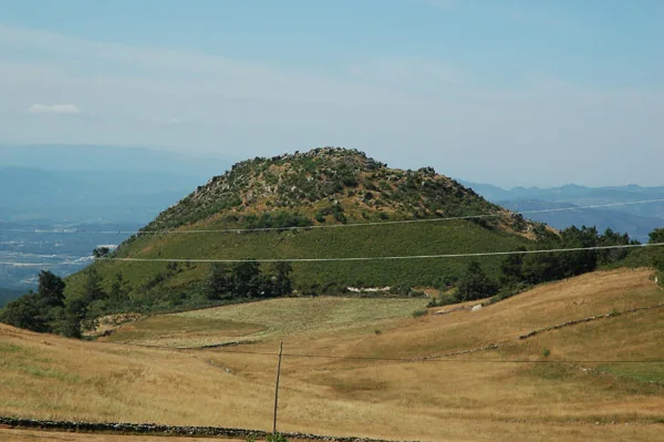
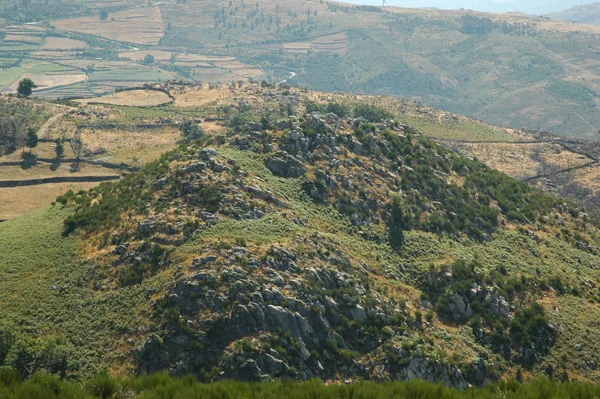
Monte do Castelo in Formigueiro.
ⓘ

Monte do Castelo in Formigueiro.

Source: Carta Arqueológica de Cabeceiras de Basto

View source

Photograph date not stated.

Autoria da fotografia e licença de reutilização não identificadas na fonte.

Request removal or correct the photo credit

Monte do Castelo in Formigueiro.
ⓘ

Monte do Castelo in Formigueiro.

Source: Carta Arqueológica de Cabeceiras de Basto

View source

Photograph date not stated.

Autoria da fotografia e licença de reutilização não identificadas na fonte.

Request removal or correct the photo credit

At Monte do Castelo, the terrain is part of the story.

The municipal inventory proposes a small fortified settlement from the first millennium BC. The interpretation rests on the ground’s platforms and its position overlooking an irrigated area. There is no need to imagine a medieval castle: here, the place name accompanies remains from another period.

The small rise and regular platforms are two clues used in the interpretation. The position overlooks an irrigated flat area extending northwards. The argument therefore combines the ground’s shape with the relationship between settlement and surroundings; the place name alone does not settle the dating.

Getting to know the parish Ver ficha: Monte do Castelo — povoado
Source and context

Municipality — archaeological inventory, interpretations and chronologies
Accessed:

Carta Arqueológica de Cabeceiras de Basto — 15.17
Accessed:

Editorial summary; the date of consultation is not the date of the facts.

Back to index ↑
Rio Douro · a possible link between archaeological sites

Tombs and settlement: a connection to investigate

At Portela de Asnela, the landscape leaves a question.

The municipal inventory describes burial mounds at Portela de Asnela, in Rio Douro, and proposes a connection with the Castelo settlement at Formigueiro, around one kilometre to the north. Proximity supports a hypothesis; it does not by itself prove that both groups of remains were used by the same community.

The entry identifies structures of the antela and cist types within the funerary group. It proposes a date in the second or first millennium BC, based on pottery and comparisons with similar groups in the mountains of the Northwest.

There are therefore two separate questions: when might these monuments have been built, and how might they have related to the nearby settlement? A proposed chronology does not automatically resolve the second question. The inventory presents that connection as a hypothesis, leaving room for future research.

Compare traces, distinguish hypotheses

Open an option and choose the story.

  1. How to interpret a villageA village drawn on the slope →
  2. Another time, other gravesTwo graves, one direction →
  3. Inhabit, store and buryThe floor also kept reserves →
Each place has its interpretation and its temporal framework.
Ver ficha: Portela de Asnela — necrópole
Source and context

Municipality — archaeological inventory, interpretations and chronologies

Accessed: . Editorial summary; the date of consultation is not the date of the facts.

Back to index ↑
Arco de Baúlhe · archaeological interpretation

Before the railway, a hillfort

Arco has a much older history too.

During Romanisation, the region’s settlements did not all follow the same path. The Archaeological Map suggests that the small hillfort at Arco de Baúlhe may have lost inhabitants while Chacim became more central. It also mentions the expansion of agricultural occupation onto lower land. This interpretation helps us imagine a changing territory, but gives no certain date for the abandonment of Arco’s hillfort.

The Map places these changes within a process beginning in the second half of the 1st century BC. Transformation extended beyond houses: relationships among settlements, fields and centres of power changed too. Chacim appears as a focus for population and renewed spaces, while Arco is presented as a possible example of depopulation.

Material from Mó de Cima, in Chacim, is used to support the agricultural occupation of lower land. Later, the text highlights open farmstead-type settlements such as Abadim. Read together, these clues show a change in territorial organisation; they do not allow a single movement of inhabitants between two points to be traced, or every change to be dated to the same year.

How did the settlement change?

Open an option and choose the story.

  1. Chacim between the mountain and the valleyBetween the mountain and the valley, the settlement changed →
  2. Abadim and agricultural occupationFrom village to farm couple →
  3. The warrior memory in stoneWarriors who stayed on the stone →
It compares the clues and interpretations of each place. They are stories of different times, not a visit itinerary.
Getting to know the parish
Source and context

Archaeological Letter of Cabeceiras de Basto — Protohistory and Romanization

Accessed: . Editorial summary; the date of consultation is not the date of the facts.

Back to index ↑
Cabeceiras · archaeological interpretation

Warriors preserved in stone

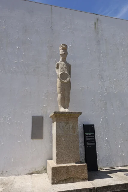
Statue of O Basto in Refojos, with a round shield, pedestal and municipal identification plaque.
Estátua do Basto in Refojos · monument photograph© Joseolgonⓘ

A figure can tell of a changing era.

O Basto and the warrior of Santa Comba are presented in the Archaeological Map as examples of Gallaecian warrior statues. The municipal interpretation connects these figures with the ritual importance of the warrior’s role during a period of community transformation. The Map also connects that ritual function with gold torcs, presenting their origin in the Cavez area as a hypothesis. Within the same picture of change, it mentions open farming settlements such as Abadim and honorific inscriptions. Romanisation appears not only in monuments: it involves settlement, practices and forms of representation.

See Fact sheet: Estátua do Basto
Source and context

Archaeological Letter of Cabeceiras de Basto — Protohistory and Romanization

Accessed: . Editorial summary; the date of consultation is not the date of the facts.

Back to index ↑
Chacim · interpreting Romanisation

Settlement shifted between mountain and valley

Romanisation also changed the relationship between mountains and fields.

Romanisation did not affect every settlement in the same way. The Archaeological Map places changes in the second half of the 1st century BC: Chacim may have strengthened its central role, while the small hillfort at Arco de Baúlhe seems to have lost inhabitants. The text offers an interpretation of remains, not a census of movements.

In Chacim, material from Mó de Cima is associated with occupation and cultivation of nearby lower land. Later, the description also points to open farming settlements, such as the farmstead identified at Abadim. The story therefore involves more than leaving the heights: it includes new centres and different ways of occupying fields.

The same source connects cultural transformation with warrior sculptures and honorific inscriptions. These are different kinds of clues: one helps us consider social representation; another offers signs of Roman practices. When exploring these stories, always ask which evidence supports each interpretation.

What clues do this change tell?

Open an option and choose the story.

  1. A village in transformationBefore the rails, a castro →
  2. The figure of the warriorWarriors who stayed on the stone →
  3. Inhabit and store in another timeThe floor also kept reserves →
Compares traces and interpretations; the sequence does not describe a proven displacement of people.
Getting to know the parish
Source and context

Archaeological Letter of Cabeceiras de Basto — Protohistory and Romanization

Municipality — archaeological inventory, interpretations and chronologies

Accessed: . Editorial summary; the date of consultation is not the date of the facts.

Back to index ↑
Rio Douro · medieval archaeology

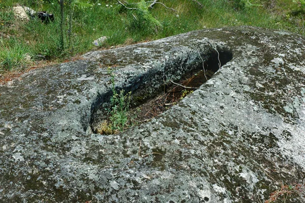
Two graves, one direction

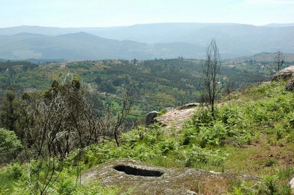
Campas dos Mouros rock-cut graves in Cambezes.
ⓘ

Campas dos Mouros rock-cut graves in Cambezes.

Source: Carta Arqueológica de Cabeceiras de Basto

View source

Photograph date not stated.

Autoria da fotografia e licença de reutilização não identificadas na fonte.

Request removal or correct the photo credit

Campas dos Mouros rock-cut graves in Cambezes.
ⓘ

Campas dos Mouros rock-cut graves in Cambezes.

Source: Carta Arqueológica de Cabeceiras de Basto

View source

Photograph date not stated.

Autoria da fotografia e licença de reutilização não identificadas na fonte.

Request removal or correct the photo credit

In Rio Douro, orientation helps interpret the past.

At Campas de Moira, the municipality describes two graves aligned east to west. It places them within north-western Christian funerary practices and offers a broad chronology between the 9th and 13th centuries. The place name and the interpretation of the remains are different clues worth reading together.

The record uses the term inhumation: burying the body. The east–west alignment and overall form are elements of the proposed interpretation, while the 9th to 13th centuries define a span of several centuries, not an exact date.

Comparing these graves with Asnela’s burial mounds helps avoid reading everything old in the same way. Both are funerary evidence, but the inventory proposes different periods and structure types. A site’s name does not replace analysis of its remains.

Getting to know the parish
Source and context

Municipality — archaeological inventory, interpretations and chronologies
Accessed:

Carta Arqueológica de Cabeceiras de Basto — 15.10
Accessed:

Editorial summary; the date of consultation is not the date of the facts.

Back to index ↑
Rio Douro · archaeological interpretation

A castle read through the ground

In Eiró, the circular shape and ditch tell a story.

The municipal inventory interprets the remains as a fortified residence of motte type, dating from the mid-13th century. It connects them with the castle mentioned in the Inquiries of 1258. The circular form stands on a mound of stone and coarse sand, surrounded by a ditch. The municipality highlights its position above the Rio Douro valley, a connection between Refojos and the Barroso plateau. This reading combines terrain and document without reconstructing the vanished building with certainty.

The 1258 document adds a social dimension to the shape of the ground: according to the municipal interpretation, almost all residents of Santo André de Rio Douro had an annual obligation to go to the castle. The reference connects the fortification with community organisation, although it does not clarify all the associated tasks here.

The inventory compares the construction with examples from Brittany. This is a comparison of forms and techniques, not proof of the builders’ origin. Its position halfway up the hillside helps explain the relationship between defence and movement through the valley.

The land and documents

Open an option and choose the story.

  1. Another village, another chronologyA village drawn on the slope →
  2. What do the documents say about PedraçaPedraça already had another name written →
  3. Funeral traces and engravings in AbadimThe stone also kept drawings →
It compares the clues and interpretations of each place. They are stories of different times, not a visit itinerary.
Getting to know the parish Ver ficha: Mota de Eiró
Source and context

Municipality — archaeological inventory, interpretations and chronologies

Accessed: . Editorial summary; the date of consultation is not the date of the facts.

Back to index ↑
YOUR LOCAL GUIDE

What would you like to discover?

Take a closer look.