Discover Cabeceiras de BastoFree independent guide
ViveCabeceirasYOUR GUIDE TO CABECEIRAS
ENEnglish
SearchSaved
8 STORIES · CONTINUOUS READING

The water that gathered the village

Follow the water between canals, fields and equipment. Compare forms of sharing and discover how an open levada passed the plumbing in Alvite. Historical documents help to read changes in the landscape; do not indicate current conditions of access.

All stories in the order of the route. You can print this page by the browser; sources and credits follow the reading.

Things to try5 activities · 1 interactive exploration · 5 questions
Rural heritage · 2008 survey

Two pools, shared water

In Além do Rio, water tells a story of neighbours.

The 2008 survey describes two pools side by side on the Levada do Recoucão in Bucos. The Poças de Vilela allowed two shared users to be served at the same time. They also received water from Veiga, shared by the whole population. The record helps explain how space was arranged to distribute a common resource.

The document adds a seasonal change: in winter there were two shared users; in summer, many. The levada also supplied four mills. The same infrastructure thus connected storage, sharing and work throughout the year.

Source and context

Municipality — inventory of levadas, fiche L8, Recoucão (28/01/2008)

Accessed: . Editorial summary; the date of consultation is not the date of the facts.

Back to index ↑
Gondiães · 2008 municipal inventory

Four pools and a shared irrigation channel

In Gondiães, storing and directing water was collective work.

Four pools supplied a shared structure. The municipal record of 20 March 2008 describes the Rego das Poças, also called Levada da Vizinhança, in Gondiães: around two kilometres of channel for irrigation and milling, serving the Tarroeiro mill.

The Poças do Lugar lay at Olheiros. Three were close together and the fourth further away. Up to the village entrance, the channel followed natural ground; within the settlement it became a stone trough. Storing and directing water therefore required different elements and materials.

The inventory identifies collective ownership and operation by the channel’s joint users, or consortes. It records seasonal water turns but leaves the construction period undetermined. The survey date is not the structure’s age. Its recorded use and condition belong to the picture of 2008, without confirming today’s situation or access.

Store, drive and distribute

Open an option and choose the story.

  1. Two puddles and other usesTwo puddles, shared water →
  2. The water also had a given timeThe water had its turn →
  3. When the water put the mills to workPeio also made flour →
Compares different documented solutions in the municipality.
Source and context

Municipality — inventory of levadas, fiche L29: Rego das Poças, withdrawal of 20/03/2008

Accessed: . Editorial summary; the date of consultation is not the date of the facts.

Back to index ↑
Rural heritage · 2008 survey

Water had a calendar

At Vessada de Baixo, the week organised irrigation.

In Santa Senhorinha, the 2008 inventory recorded three shared users on the Levada da Vessada de Baixo, fed by the Petimão stream. Casa da Cerca had the water from Monday until Wednesday night; Casa do Prado from then until Sunday. A third user had it one day every fortnight. This is a historical record of sharing, not a current timetable.

The third user is identified as Lavoura de Minas. The record describes an open channel in the ground, used throughout the year. Reading the weekly distribution shows that sharing water also required organising time.

Source and context

Municipality — inventory of levadas, record L5, Vessada de Baixo (11/04/2008)

Accessed: . Editorial summary; the date of consultation is not the date of the facts.

Back to index ↑
Rural heritage · 2008 survey

One water supply, several tasks

In Eiró, the oil mill connected with field irrigation.

The inventory of 7 February 2008 describes the olive-oil mill at Casa da Portelada in Eiró, Rio Douro, alongside a grain mill in the same building with a separate entrance. Water from the Levada de Moinhos powered the equipment before continuing to irrigate fields. This successive use connected food processing with farming. The record of private property does not confirm current visiting arrangements.

The record places the oil mill’s former working season in January and February. It also describes water arriving from the west through a granite structure, and distinguishes the grain mill’s northern entrance from the oil mill’s southern entrance. These are clues to the building’s arrangement. The document contains contradictory information about surviving parts, so it cannot establish that the whole installation was complete or operational.

Source and context

Municipality — Lagares inventory, LA20 fiche, Portelada House (07/02/2008)

Accessed: . Editorial summary; the date of consultation is not the date of the facts.

Back to index ↑
Saint Nicholas · hydraulic heritage inventoryed in 2008

The Peio made flour too

A river connected fields, weirs and mills.

The Levada do Casal record notes water drawn from the Peio near Ponte do Gado, in Gondarém. The inventory describes five mills along the channel. It is a record of water-powered heritage, not confirmation that the mills operate or are publicly accessible today.

The survey of 26 February 2008 identifies a channel in natural ground and two shared users: Casa do Casal and Quinta do Rapazinho, the latter with less irrigation time. It also describes the route near the Levada de Bouças and a boundary marker in Sendim placed to settle a disagreement over use. The channel carried water, but its use also depended on agreements between people.

Source and context

Municipality — inventory of taken, L1 and L18 forms (uplifts of 2008)

Accessed: . Editorial summary; the date of consultation is not the date of the facts.

Back to index ↑
Rural heritage · 2008 survey

The stones on the way to the mill

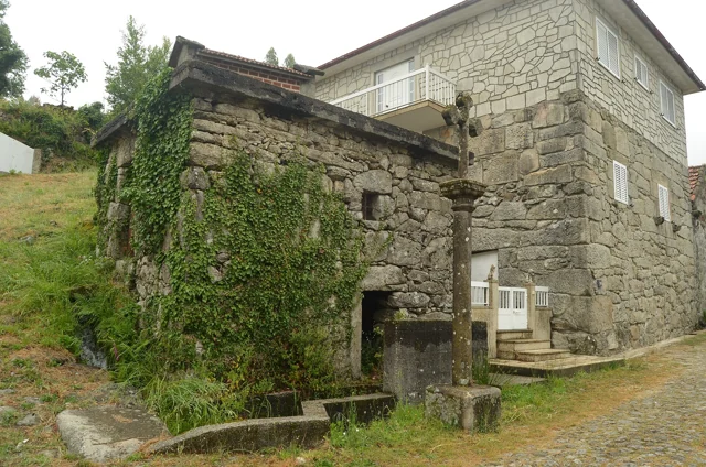
A corner of Carrazedo, Bucos, with a fountain, stone cross and stone buildings.
Place linked to this story: Carrazedo© Pedro from Maia (Porto), Portugalⓘ

A short paved stretch tells a working story.

At Carrazedo in Bucos, the survey of 11 January 2008 recorded about 30 metres of paving beside the wayside cross, providing access to two mills. The granite slabs varied in shape and size. These short paths are also part of rural heritage: they connected the village with places where grain was processed. The inventory cannot confirm their condition or access today. Carrazedo’s profile introduces the village to which this memory belongs; it does not mark the exact location of the thirty metres of paving.

See Fact sheet: Carrazedo
Source and context

Municipality — sidewalk inventory, Carrazedo, C5 fiche (11/01/2008)

Accessed: . Editorial summary; the date of consultation is not the date of the facts.

Back to index ↑
Water memory · lifting of 2008

Water had its turn

From sunset to sunset, a community rule.

The survey of 4 March 2008 describes water from the Levada de Víbora shared in eleven 24-hour turns, called casais. Each turn began at sunset and ended at the following sunset. The starting order changed from year to year.

The names came from houses in Abadim: six casais were associated with Aldeia da Torre and five with Santo António. The granite channel carried water from the Busteliberne stream for irrigation and milling. The levada therefore had both a visible structure and an equally important organisation of time. These details belong to the 2008 inventory, not a current irrigation schedule.

Source and context

Municipality — inventory of taken, L1 and L18 forms (uplifts of 2008)

Accessed: . Editorial summary; the date of consultation is not the date of the facts.

Back to index ↑
Alvite and Passos · irrigation documented in 2008

The water changed its path

A channel can vanish from view and remain in memory.

The municipal record for Poça do Monte, surveyed on 14 April 2008, describes a change in Alvite: the shared users piped the natural-ground channel in 2001. It was about one kilometre long and used water from the Ribeiro Furado spring.

The record identifies seven shared users and mentions a steep initial slope. This story helps distinguish the old open channel from piped water conveyance. The document cannot establish the network’s condition today and does not present a walking route.

Source and context

Municipality — inventory of levadas, L2, survey of 14/04/2008

Accessed: . Editorial summary; the date of consultation is not the date of the facts.

Back to index ↑
YOUR LOCAL GUIDE

What would you like to discover?

Take a closer look.