Discover Cabeceiras de BastoFree independent guide
ViveCabeceirasYOUR GUIDE TO CABECEIRAS
ENEnglish
SearchSaved
CHOICE · EXPERIMENTARY · TAKE

A notebook.
Your findings.

Up to six proposals of Cabeceiras, in your own order, to do it at home, in company or on a break.

3 de 6 propostas escolhidas · faça-as ao seu ritmo.

PROPOSTA 1 DE 3 · Read the landscape through the plants

Try observing

Hillside crops · olive botany

One leaf, two sides

The municipality’s landscape description includes olive trees on the hillsides of Cabeceiras. The cultivated olive has leaves that are grey-green above and silvery-grey beneath, where hairs grow. Its small flowers have four white petals joined at the base. The fruit is the olive, an oil-rich drupe. The University of Évora’s description follows the change from green to reddish and dark shades during ripening, but also mentions forms that remain green when ripe. Colour alone does not tell the fruit’s whole story. The connection from tree to olive oil continues in the story of the Ramil oil mill. The profile distinguishes the cultivated olive from its wild form, known in Portuguese as zambujeiro. The latter is described as having smaller leaves and fruits and thorny lower branches. This comparison shows why a single feature, such as the silvery underside of a leaf, does not explain every difference. The olive is evergreen: it retains foliage throughout the year. You can therefore return to the same tree in different seasons and compare leaves, flowers and fruits, without expecting to find them all at once.
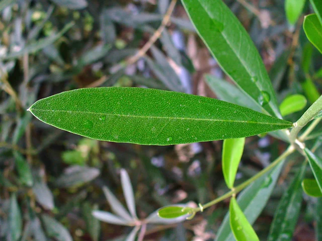
An elongated green olive leaf with a pale central vein and other leaves behind it.
An olive leaf photographed in Stutensee, Germany, in 2011. Botanical illustration, not an observation from Cabeceiras. This view does not show both sides of the same leaf.
Photography: H. Zell · CC BY-SA 3.0
About this photograph

Date given at source: . Source consulted in 2026-11-07. EXIF orientation, proportional resizing and WebP conversion; no retouching or clipping of the file.

Request removal or correct the photo credit

Vamos experimentar?

  1. Observes the photograph: draw the contour and the central nerve of the sheet.
  2. The image does not show the two sides of the same sheet. Separate what you see from what the text explains on the lower face.
  3. If you observe an olive tree throughout the year, record separately leaves, flowers and fruits, without taking off material.

An activity to try at your own pace, without collecting specimens.

Open a história e os seus recursos →
Sources of this proposal

My findings

An idea, a drawing or a question to go on.

PROPOSTA 2 DE 3 · Travel through time

Try observing

Gondiães and Vilar de Cunhas · memory and landscape

A house with three granaries

At Casa de Chouzas, three 19th-century granaries stand alongside the manor house highlighted by the municipality. The group connects two functions: living and storing the harvest. Rather than looking only at the main house, it is worth recognising the importance of buildings supporting agriculture. The introduction to Vilar de Cunhas places this heritage in a landscape of plateau and mountain, shaped by farming and pastoralism. House and granaries can be read in that working context, although the source does not detail each property’s production. The house’s dating is less firm: the municipality presents it as perhaps 19th-century, while assigning the granaries to the 19th century. That difference should remain visible. The photograph accompanying the reading shows the portal, not the three granaries. The heritage reference does not confirm access to the group.

Vamos experimentar?

  1. Look at the photo of the portal and list only the elements you can see.
  2. Compared to the three granaries mentioned in the text: what depends on the written description?
  3. Imagine a caption that distinguishes the frame of the photograph from the remaining patrimonial set.

An activity to try at your own pace, without collecting specimens.

Open a história e os seus recursos →
Sources of this proposal

My findings

An idea, a drawing or a question to go on.

PROPOSTA 3 DE 3 · Travel through time

Draw the links of the village

Bucos · transport in 1758

A small bridge on a long route

At Casares, a wooden bridge formed part of the royal road to Braga and the connections with Trás-os-Montes, according to the 1758 account. Given the traffic, the vicar argued for rebuilding it in stone. This was a request, not confirmation of completed work. The source distinguishes that crossing from small pedestrian footbridges made with a wooden beam. Different crossings answered different needs. The crossing did not serve only the village. The vicar describes a busy public road connecting Braga with the jurisdiction of Basto and Trás-os-Montes. The bridge therefore appears as a local point in a larger network. His recommendation to replace it with dressed stone shows the author assessing a need as well as recording what existed. In the same rivers, water drove mills and was used by farmers in their fields. Crossing, milling and irrigation appear in the same portrait of the territory. A bridge can be read through what it makes possible: reaching another place, maintaining a connection or bringing work on opposite sides of the water closer together.

Vamos experimentar?

  1. Write on a sheet Casares, parish church, Fox and mills, without putting them on a real map.
  2. Connect each name to the need described: crossing, receiving news, cult or grinding.
  3. It distinguishes what the text describes from what it merely proposes, such as the stone bridge.

Scheme of historical relations, without distances or indication of itinerary.

Open a história e os seus recursos →
Sources of this proposal

My findings

An idea, a drawing or a question to go on.

YOUR LOCAL GUIDE

What would you like to discover?

Take a closer look.