Discover Cabeceiras de BastoFree independent guide
ViveCabeceirasYOUR GUIDE TO CABECEIRAS
ENEnglish
SearchSaved
CHOICE · EXPERIMENTARY · TAKE

A notebook.
Your findings.

Up to six proposals of Cabeceiras, in your own order, to do it at home, in company or on a break.

3 de 6 propostas escolhidas · faça-as ao seu ritmo.

PROPOSTA 1 DE 3 · Travel through time

Try observing

Gondiães and Vilar de Cunhas · memory and landscape

A house with three granaries

At Casa de Chouzas, three 19th-century granaries stand alongside the manor house highlighted by the municipality. The group connects two functions: living and storing the harvest. Rather than looking only at the main house, it is worth recognising the importance of buildings supporting agriculture. The introduction to Vilar de Cunhas places this heritage in a landscape of plateau and mountain, shaped by farming and pastoralism. House and granaries can be read in that working context, although the source does not detail each property’s production. The house’s dating is less firm: the municipality presents it as perhaps 19th-century, while assigning the granaries to the 19th century. That difference should remain visible. The photograph accompanying the reading shows the portal, not the three granaries. The heritage reference does not confirm access to the group.

Vamos experimentar?

  1. Look at the photo of the portal and list only the elements you can see.
  2. Compared to the three granaries mentioned in the text: what depends on the written description?
  3. Imagine a caption that distinguishes the frame of the photograph from the remaining patrimonial set.

An activity to try at your own pace, without collecting specimens.

Open a história e os seus recursos →
Sources of this proposal

My findings

An idea, a drawing or a question to go on.
PROPOSTA 2 DE 3 · Life you do not always see

Compare two faces

Badger · general biology

A home beneath the ground

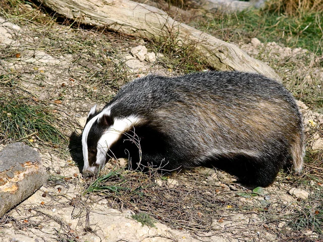
The European badger, Meles meles, is mainly nocturnal and shelters in extensive underground setts. Two dark stripes on a white head are a striking visual clue; its short legs have strong claws. Museu Virtual da Biodiversidade describes its presence in woods, forests and farmland with vegetation. This profile explains the species in mainland Portugal; it does not document an observation in Cabeceiras de Basto. The claws are long and non-retractile: they do not draw back like a cat’s. A short, pale tail provides another contrast with a fox’s long tail. These details help compare descriptions without searching for or disturbing setts.

Badger with gray body and head with light and dark bands, next to the ground.
Badger at the British Wildlife Centre in Newchapel, Surrey, UK, in 2011. Animal in fauna park; not a record of Cabeceiras.
Photography: Peter Trimming · CC BY 2.0
About this photograph

Date given at source: . Source consulted in 2026-11-07. EXIF orientation, proportional resizing and WebP conversion of the current version in Commons; no retouching or additional clipping.

Request removal or correct the photo credit

Vamos experimentar?

  1. In the photograph, it follows the light and dark bands of the head and the contour of the body.
  2. Compare the text with the image: the description of the claws and the den goes beyond what this framework shows.
  3. Open the otter story and compare the snouts in the two photographs, keeping the contexts of each park separate.

The badger was photographed at the British Wildlife Centre in the UK. A daylight photograph in a park does not invalidate the description of the species' mostly nocturnal habits.

Open a história e os seus recursos →
Sources of this proposal

My findings

An idea, a drawing or a question to go on.

PROPOSTA 3 DE 3 · Travel through time

Try drawing

Arco de Baúlhe · archaeological interpretation

Before the railway, a hillfort

During Romanisation, the region’s settlements did not all follow the same path. The Archaeological Map suggests that the small hillfort at Arco de Baúlhe may have lost inhabitants while Chacim became more central. It also mentions the expansion of agricultural occupation onto lower land. This interpretation helps us imagine a changing territory, but gives no certain date for the abandonment of Arco’s hillfort. The Map places these changes within a process beginning in the second half of the 1st century BC. Transformation extended beyond houses: relationships among settlements, fields and centres of power changed too. Chacim appears as a focus for population and renewed spaces, while Arco is presented as a possible example of depopulation. Material from Mó de Cima, in Chacim, is used to support the agricultural occupation of lower land. Later, the text highlights open farmstead-type settlements such as Abadim. Read together, these clues show a change in territorial organisation; they do not allow a single movement of inhabitants between two points to be traced, or every change to be dated to the same year.

Vamos experimentar?

  1. Draw two villages and fields among them.
  2. Use arrow keys to represent the hypothesis of population change; do not draw a historical route as if it were proven.
  3. Compare the history of the Arch with that of the agricultural couple of Abadim.

A paper proposal to explore history at your own pace.

Open a história e os seus recursos →
Sources of this proposal

My findings

An idea, a drawing or a question to go on.

YOUR LOCAL GUIDE

What would you like to discover?

Take a closer look.