Discover Cabeceiras de BastoFree independent guide
ViveCabeceirasYOUR GUIDE TO CABECEIRAS
ENEnglish
SearchSaved

Rivers and mountains

Choose a story to start with. You can change the subject or fine tune the search.

8 stories · Between rivers and mountains · Search: nascentes

Between rivers and mountains

Water and relief form the municipality. Choose a name and follow the landscape.

Choose a story · 8
Ribeira de Cavez · water and agriculture

From spring to fields
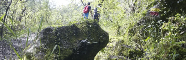
Landscape at Trilho da Ribeira de Cavez.

A stream helps explain an entire landscape.

Read here and view sources

The Cavez stream rises on the municipality’s boundary with Montalegre and ends in the Tâmega. Between mountain and mouth, the municipal description highlights irrigation channels, mills and watered meadows: structures and fields showing different ways of using water.

On the trail starting in Vilela, Rio Douro, the account moves from the descent to the stream towards the irrigation channel and meadow landscape, then along rural tracks and the hillside. Returning to the village brings another material into the story: the granite masonry of its houses. Consult the route profile to prepare your walk; this story explains the landscape without confirming the path’s condition on the day of your visit.

The municipal description presents the section along the channel to Reboriça as gently sloping; the hillside climb is the most demanding part. Water does not tell the whole story of effort: the return matters too.

Try reading a photograph of this landscape in three layers: water, fields and houses. Look for a line carrying water, a plot depending on it and a building material. Can you explain how the three relate? This observation exercise can also be done at home.

Getting to know the parish See Fact sheet: Trilho da Ribeira de Cavez See Fact sheet: Vilela, Rio Douro
Source and context

Municipality — stream of Cavez and agricultural landscape
Consultations: ,

Editorial summary; the date of consultation is not the date of the facts.

Rio Douro · Parish memories of 1758

Two rivers tell a parish’s story

The 1758 account describes Rio Douro between east and west.

Includes an activity to try →Explore: Water linking villages and works →
Read here and view sources

In the 1758 account, the Vilela river flowed to the east and the Rio Douro river to the west, both from north to south. The parish priest described their origins in small springs and their waters increasing with contributions from the mountains. He said the Vilela entered the Tâmega below Cavez bridge and the other joined the river coming from São Nicolau. These are the names and geographical relationships in that document, not a current navigation map.

Bridges bring that geography closer to village life. The document mentions a wooden crossing between Magusteiro and Teixugueiras and a stone one between Teixugueiras and the church. It also refers to wooden links from Eiró and Rio Douro to the church, and a stone one between Vilela and the church. Water and paths therefore appear in the same portrait of the parish.

The priest describes rivers with rocks, weirs and waterfalls, unsuitable for navigation but useful to mills and fields. They were more than lines separating places: they belonged to work and travel. These references come from the testimony signed on 22 May 1758; they do not confirm the survival of structures or present access to the banks.

There is a clue to imagining the relief: the author describes three parallel mountain ridges extending from Salto, with rivers in the lower spaces. The ridges’ names varied between places. Rather than seeking a single name for each mountain line, the document invites us to connect position, villages and the direction of water.

Words in this story: see explanations →Getting to know the parish
Source and context

Municipality of Cabeceiras de Basto — Parish memories of 1758: Rio Douro

Accessed: . Editorial summary; the date of consultation is not the date of the facts.

Saint Nicholas and Painzela · testimony of 1758

A bridge for loaded carts

Three springs and a crossing connected two parishes.

Includes an activity to try →Explore: Pass, water and grind →
Read here and view sources

In 1758, the parish priest describes a small river rising from three springs on the hills of Lapela and Celeiró. It entered Painzela through Vilarinho, where a wooden bridge supported loaded carts. The testimony does not identify a crossing that can be visited today.

The same river also powered mills and supplied an irrigation channel for the fields of Casal. The author recalls two other diversions linked to the Taipa estate, one already ruined when the account was written.

This description brings together transport, milling and irrigation. A bridge allowed crossing; a channel diverted some water to another use. Their functions were not equivalent, although they belonged to the same working landscape. The reference to a ruined structure also shows that the document records changes and losses alongside what was working.

Words in this story: see explanations →
Source and context

Basto Land Museum — St Nicholas Parish Memories, 22 May 1758

Accessed: . Editorial summary; the date of consultation is not the date of the facts.

Alvite · 1758 account

Storing water from the hillside

Small springs helped irrigate the fields.

Includes an activity to try →
Read here and view sources

In the 1758 account, the vicar of Alvite described small springs in the Serra da Orada. Residents held this water in pools to benefit east-facing fields. Storing water was a way of dealing with scarcity.

The same document described the parish as dry, particularly in summer, and noted the absence of grain mills and fulling mills. Two olive-oil mills worked with oxen and other animals; to grind cereals, many residents went to neighbouring parishes. The account links natural resources, techniques and journeys without establishing that the same uses or structures survive today.

Getting to know the parish
Source and context

Basto Land Museum — Parish Memories of 1758: Alvite

Accessed: . Editorial summary; the date of consultation is not the date of the facts.

Geographical framework

The Tâmega traces the boundary

A river that helps explain the south of the municipality.

Includes an activity to try →Explore: From limit to landscape →
Read here and view sources

The Tâmega follows much of Cabeceiras’s southern and south-eastern boundary. To the east, the municipality’s geographical introduction mentions the River Bessa. Water therefore helps locate the territory, alongside the mountains to the north and west.

The neighbouring municipalities to the south are Celorico de Basto and Mondim de Basto; Ribeira de Pena lies to the east. These references offer a starting point for reading the map before moving on to bridges, fields and the tributary network.

Complete the picture by looking to the other sides: Montalegre and Boticas to the north, Vieira do Minho to the north-west and Fafe to the west. Cabreira and Barroso frame the north; the Serra da Lameira frames the west. Administrative boundaries and the water network are two different ways to read the same territory: follow the tributaries next to see where the water goes.

Source and context

Municipality — geographical framework

Accessed: . Editorial summary; the date of consultation is not the date of the facts.

Santa Senhorinha · 1758 account

The river became part of farming life

A cultivated riverbank tells history too.

Includes an activity to try →Explore: One river, four stories →
Read here and view sources

The 1758 account describes the river of Santa Senhorinha flowing all year, but with little water in summer. It describes cultivated banks, fruit trees and wild trees, linking water with irrigation and rural work.

Vila de Lobos and Cainhos had olive-oil mills; grain mills are mentioned in Vila de Lobos and Sestelo. The same description follows several river uses: growing crops, grinding grain and processing olives. It does not confirm which facilities survive or operate today.

Unlike the rushing currents described at São Nicolau, the abbot characterises this river as calm and flowing from west to east. He begins its course at Aboim and lists Várzea Cova, Passos and São Clemente before Santa Senhorinha. This is the geography reported in the document, not a current delineation of the watercourse.

Residents’ use of water for the fields is described as unrestricted. The account was signed on 23 May 1758. That detail matters: the reference to little water in summer describes a pattern known to the author, not an observation made during that year’s summer.

Words in this story: see explanations →
Source and context

Municipality — Memória de Santa Senhorinha, 23/05/1758; transcript of José Viriato Chapel (2003)

Accessed: . Editorial summary; the date of consultation is not the date of the facts.

St Nicholas and Painzela · hydrography in the testimony of 1758

Two rivers meet at Ranha

A document lets us follow water between parishes.

Explore: Follow water in document →
Read here and view sources

The 1758 São Nicolau account places the meeting of the river crossing the parish with the one from Painzela at Ponte da Ranha. It then describes their combined flow heading towards the Tâmega near Cavez bridge. This is a historical reading of the water network connecting the territory, not a suggested riverside walk.

Before that meeting, the priest follows São Nicolau’s river from the hill called Víbora. He describes a modest spring receiving other streams, its flow strengthened at Ponte do Gado by two branches from Bucos. He mentions water throughout the year and a particularly strong winter flow.

The text also follows changes of direction: south, then east, then south again. It tells the landscape through the movement of water. Springs, tributaries and confluence explain different stages; the author’s names belong to the testimony signed on 22 May 1758.

Notice the sequence of meetings: the Bucos branches first strengthen São Nicolau’s flow; water from Painzela joins at Ranha; their shared destination is the Tâmega. Drawing these junctions helps distinguish a river’s course from the network of contributions feeding it.

Words in this story: see explanations →
Source and context

Basto Land Museum — St Nicholas Parish Memories (1758)

Accessed: . Editorial summary; the date of consultation is not the date of the facts.

Council · Water resources in the 2025 report

There is water beneath the ground too

The map of water resources does not end at the surface.

Includes an activity to try →Explore: Look at the water in different ways →
Read here and view sources

For groundwater, the municipal environmental report of February 2025 identifies units of the Undifferentiated Ancient Massif associated with the Douro, Ave and Cávado basins. In the same document, the municipality’s surface-water bodies belong to the Douro River Basin District. These are different readings of the territory: rivers at the surface and water underground. The reference does not identify wells to visit or assess the water in any spring.

How does water fit inside rock? The USGS explanation points to pores and fractures: spaces between particles and cracks that can contain water. Porosity describes the available spaces; permeability describes how easily water flows through the material. Spaces alone are not enough: the connections between them matter too. This is a general explanation, not a measurement of Cabeceiras’s rocks.

Source and context

Municipality — Environmental Report of the PDM review, February 2025, pp. 56–58: water network and resources

USGS — Water Science School: groundwater, porosity and permeability

Accessed: . Editorial summary; the date of consultation is not the date of the facts.

YOUR LOCAL GUIDE

What would you like to discover?

Take a closer look.