Outeiro: one place, several layers of time
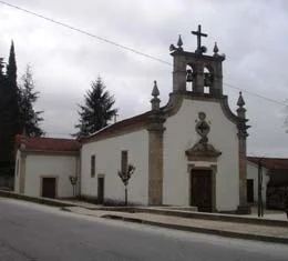
Ancient remains, a medieval image and houses beside the road.
Text size
Your choice is saved only in this browser.
Outeiro has more than one doorway into its history. The archaeological inventory in the municipal plan published in 2026 identifies the medieval cemetery of Mata Santa, the Serra da Penouta shelter attributed to the Neolithic/Chalcolithic, and Outeiro da Pena, recorded as a shelter or lookout with prehistoric and medieval references. These are traces of different periods, not a foundation date.
Another medieval presence is a sculpture of Saint Mary, dated to the thirteenth or fourteenth century in a municipal report from 2012. The account says it was found buried at Mata da Santa and taken to the church by parishioners. The report does not date the discovery, and a similar place-name alone cannot connect the image with each archaeological remain.
The more recent landscape adds another layer. The municipal description presents a gently rolling plateau and houses established along the road near the municipal seat. Ways of living also change with routes.
Between the ground, the image and the road, Outeiro offers different approaches to the past. One object cannot tell everything, but several clues bring us closer to the long life of this territory.
Explore further: words and activities
Explore this story
Source and context
Municipality — Parish of Outeiro exposes acquis No Núcleo de Arte Sacra, 09/10/2012
Municipality — Outeiro, relief and hydrographic network
Accessed: . Editorial summary; the date of consultation is not the date of the facts.