Discover Cabeceiras de BastoFree independent guide
ViveCabeceirasYOUR GUIDE TO CABECEIRAS
ENEnglish
SearchSaved
CHOICE · EXPERIMENTARY · TAKE

Your notebook

Choose up to six ideas, try them and take your discoveries with you.

3 de 6 propostas escolhidas · faça-as ao seu ritmo.

PROPOSTA 1 DE 3 · Travel through time

Try to interpret

Reorder or remove

Rio Douro · archaeological interpretation

Vamos experimentar?

  1. Read the description and draw only the elements it mentions: circular shape, landfill and moat.
  2. Tick with another color something I would like to know, but the text does not clarify.
  3. Compare your drawing with the reading of Monte do Castelo. What clues come from the terrain and what interpretations?

A proposal for reading and drawing; does not require movement to the site.

Discover the story

A castle read through the ground

The municipal inventory interprets the remains as a fortified residence of motte type, dating from the mid-13th century. It connects them with the castle mentioned in the Inquiries of 1258. The circular form stands on a mound of stone and coarse sand, surrounded by a ditch. The municipality highlights its position above the Rio Douro valley, a connection between Refojos and the Barroso plateau. This reading combines terrain and document without reconstructing the vanished building with certainty. The 1258 document adds a social dimension to the shape of the ground: according to the municipal interpretation, almost all residents of Santo André de Rio Douro had an annual obligation to go to the castle. The reference connects the fortification with community organisation, although it does not clarify all the associated tasks here. The inventory compares the construction with examples from Brittany. This is a comparison of forms and techniques, not proof of the builders’ origin. Its position halfway up the hillside helps explain the relationship between defence and movement through the valley.

Open a história e os seus recursos →
Sources of this proposal

My findings

An idea, a drawing or a question to go on.
PROPOSTA 2 DE 3 · Travel through time

Try observing

Reorder or remove

Gondiães and Vilar de Cunhas · memory and landscape

Vamos experimentar?

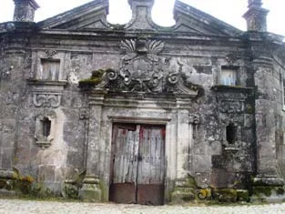
  1. Look at the photo of the portal and list only the elements you can see.
  2. Compared to the three granaries mentioned in the text: what depends on the written description?
  3. Imagine a caption that distinguishes the frame of the photograph from the remaining patrimonial set.

An activity to try at your own pace, without collecting specimens.

Discover the story

A house with three granaries

At Casa de Chouzas, three 19th-century granaries stand alongside the manor house highlighted by the municipality. The group connects two functions: living and storing the harvest. Rather than looking only at the main house, it is worth recognising the importance of buildings supporting agriculture. The introduction to Vilar de Cunhas places this heritage in a landscape of plateau and mountain, shaped by farming and pastoralism. House and granaries can be read in that working context, although the source does not detail each property’s production. The house’s dating is less firm: the municipality presents it as perhaps 19th-century, while assigning the granaries to the 19th century. That difference should remain visible. The photograph accompanying the reading shows the portal, not the three granaries. The heritage reference does not confirm access to the group.

Municipal archive photograph: Casa de Chouzas.
Portal da Casa de Chouzas · photo of the municipal inventory; the granaries do not appear in this framework.ⓘ
Open a história e os seus recursos →
Sources of this proposal

My findings

An idea, a drawing or a question to go on.

PROPOSTA 3 DE 3 · Crafts and memories

Compare two solutions

Reorder or remove

Alvite and Passos · irrigation documented in 2008

Vamos experimentar?

  1. Split a sheet into two columns: before and after.
  2. Note the change described in the text and the date of the source.
  3. Write a question the document leaves open.

Exploitation of the document, no visit to the real estate.

Discover the story

The water changed its path

The municipal record for Poça do Monte, surveyed on 14 April 2008, describes a change in Alvite: the shared users piped the natural-ground channel in 2001. It was about one kilometre long and used water from the Ribeiro Furado spring. The record identifies seven shared users and mentions a steep initial slope. This story helps distinguish the old open channel from piped water conveyance. The document cannot establish the network’s condition today and does not present a walking route.

Open a história e os seus recursos →
Sources of this proposal

My findings

An idea, a drawing or a question to go on.

YOUR LOCAL GUIDE

What would you like to discover?

Take a closer look.