Discover Cabeceiras de BastoFree independent guide
ViveCabeceirasYOUR GUIDE TO CABECEIRAS
ENEnglish
SearchSaved
CHOICE · EXPERIMENTARY · TAKE

Your notebook

Choose up to six ideas, try them and take your discoveries with you.

3 de 6 propostas escolhidas · faça-as ao seu ritmo.

PROPOSTA 1 DE 3 · Travel through time

Try observing

Reorder or remove

Gondiães and Vilar de Cunhas · memory and landscape

Vamos experimentar?

  1. Look at the photo of the portal and list only the elements you can see.
  2. Compared to the three granaries mentioned in the text: what depends on the written description?
  3. Imagine a caption that distinguishes the frame of the photograph from the remaining patrimonial set.

An activity to try at your own pace, without collecting specimens.

Discover the story

A house with three granaries

At Casa de Chouzas, three 19th-century granaries stand alongside the manor house highlighted by the municipality. The group connects two functions: living and storing the harvest. Rather than looking only at the main house, it is worth recognising the importance of buildings supporting agriculture. The introduction to Vilar de Cunhas places this heritage in a landscape of plateau and mountain, shaped by farming and pastoralism. House and granaries can be read in that working context, although the source does not detail each property’s production. The house’s dating is less firm: the municipality presents it as perhaps 19th-century, while assigning the granaries to the 19th century. That difference should remain visible. The photograph accompanying the reading shows the portal, not the three granaries. The heritage reference does not confirm access to the group.
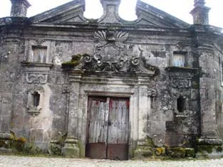
Municipal archive photograph: Casa de Chouzas.
Portal da Casa de Chouzas · photo of the municipal inventory; the granaries do not appear in this framework.ⓘ
Open a história e os seus recursos →
Sources of this proposal

My findings

An idea, a drawing or a question to go on.

PROPOSTA 2 DE 3 · Read the landscape through the plants

Try observing

Reorder or remove

Common names used in the source

Vamos experimentar?

  1. In a landscape design, use different symbols for trees, shrubs and fields.
  2. Compare the spots: where you find continuity and where there are intervals? You can do the exercise from a photograph.
  3. Choose one of the plans of this story and open the related reading to discover a detail.

An activity to try at your own pace, without collecting specimens.

Discover the story

Strawberry tree, carqueja and gorse

Strawberry tree, carqueja, gorse and honeysuckle appear in the municipality’s description of mountain vegetation. The source also links upland scrub to grazing goats, cattle and sheep, distinguishing it from cultivated pasture lower down. Scrub is therefore part of a landscape of plants, animals and work. These common names are starting points for learning about vegetation, not identifications of every plant you encounter. The municipal account relates this vegetation to changing land use: it mentions the partial replacement of oaks, chestnuts and scrub by maritime pine. Reading the landscape therefore also means asking what was planted and what changed. One green patch may hold stories of grazing, cultivation and forestry. Start by choosing a detail in the next stories: a carqueja stem, gorse spines, the strawberry tree’s flowers and fruits, or honeysuckle’s place at the woodland edge. Each question brings you closer without requiring you to identify every plant already.

Open a história e os seus recursos →
Sources of this proposal

My findings

An idea, a drawing or a question to go on.

PROPOSTA 3 DE 3 · Between rivers and mountains

Draw a river inside

Reorder or remove

Middle and upper Tâmega basin · landscape studied in 2016–2017

Vamos experimentar?

  1. Draws a bank, water and the bottom of the river.
  2. Opens each area of the scheme and chooses a relationship to represent in the drawing.
  3. Use arrow keys to connect environments; a species may depend on more than one zone.

An activity with paper and pencil, from the scheme. It is not necessary to enter the water or collect organisms.

Discover the story

The river has a woodland too

The 2016–2017 report describes riverside woodland in the middle and upper Tâmega basin with alders, ashes and willows, and birches along smaller waterways. It notes that these strips are often narrow, constrained by cultivated land. This is the regional description from that study, which covers Cabeceiras and other municipalities. Bank, water and riverbed are connected but offer different conditions. The gold-striped salamander depends on damp environments and reproduces in water; young freshwater mussels live buried in the riverbed and need oxygen. The diagram explores these general relationships without representing a place where all these species have been observed together. Read a riverbank photograph in three bands: tree crowns, ground beside the water and riverbed. Choose a species from these readings and consider which band it needs at each life stage. One landscape can contain different shelter, food and breeding places. That combination makes a river worth observing slowly.

Open a história e os seus recursos →
Sources of this proposal

My findings

An idea, a drawing or a question to go on.

YOUR LOCAL GUIDE

What would you like to discover?

Take a closer look.