Discover Cabeceiras de BastoFree independent guide
ViveCabeceirasYOUR GUIDE TO CABECEIRAS
ENEnglish
SearchSaved
CHOICE · EXPERIMENTARY · TAKE

Your notebook

Choose up to six ideas, try them and take your discoveries with you.

3 de 6 propostas escolhidas · faça-as ao seu ritmo.

PROPOSTA 1 DE 3 · Travel through time

Try observing

Reorder or remove

Gondiães and Vilar de Cunhas · memory and landscape

Vamos experimentar?

  1. Look at the photo of the portal and list only the elements you can see.
  2. Compared to the three granaries mentioned in the text: what depends on the written description?
  3. Imagine a caption that distinguishes the frame of the photograph from the remaining patrimonial set.

An activity to try at your own pace, without collecting specimens.

Discover the story

A house with three granaries

At Casa de Chouzas, three 19th-century granaries stand alongside the manor house highlighted by the municipality. The group connects two functions: living and storing the harvest. Rather than looking only at the main house, it is worth recognising the importance of buildings supporting agriculture. The introduction to Vilar de Cunhas places this heritage in a landscape of plateau and mountain, shaped by farming and pastoralism. House and granaries can be read in that working context, although the source does not detail each property’s production. The house’s dating is less firm: the municipality presents it as perhaps 19th-century, while assigning the granaries to the 19th century. That difference should remain visible. The photograph accompanying the reading shows the portal, not the three granaries. The heritage reference does not confirm access to the group.
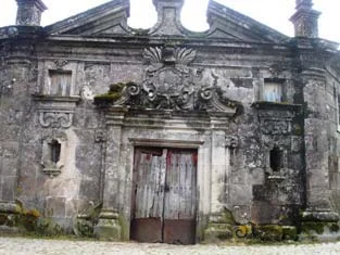
Municipal archive photograph: Casa de Chouzas.
Portal da Casa de Chouzas · photo of the municipal inventory; the granaries do not appear in this framework.ⓘ
Open a história e os seus recursos →
Sources of this proposal

My findings

An idea, a drawing or a question to go on.

PROPOSTA 2 DE 3 · Travel through time

Who took care of every chapel?

Reorder or remove

Alvite · 1758 account

Vamos experimentar?

  1. Make a list of the six names of the document.
  2. Associates each chapel with the house, customers or entities indicated for the charges.
  3. It marks the exception of Saint Mamede and distinguishes maintenance, property and access: the source does not respond in the same way to the three questions.

An activity to try at your own pace, without collecting specimens.

Discover the story

Six chapels, different responsibilities

The Alvite account lists six chapels in 1758. Santo Antonino belonged to the house and estate of that name; Bom Despacho stood beside Casa de Alvação; Sagrada Família beside Casa da Torre. These three are presented as private. The others were São Mamede in Petimão, Santa Catarina on the hill of the same name and São Sebastião in Chão. The text assigns costs to parishioners but makes an exception for São Mamede: there, the convent of Refojos and the abbot of São Clemente were responsible as joint beneficiaries. The word fábrica concerns these maintenance responsibilities, not an industrial factory. These are relationships from 1758, establishing neither present ownership nor access.

Open a história e os seus recursos →
Sources of this proposal

My findings

An idea, a drawing or a question to go on.

PROPOSTA 3 DE 3 · Between rivers and mountains

Compares three ways to use water

Reorder or remove

Cavez · landscape described in 1758

Vamos experimentar?

  1. It makes three columns: Cavez, Bucos and Alvite.
  2. After reading the related stories, note where water, mills or water retention appear.
  3. Emphasize a difference and write the explanation given by the document. Do not make it a description of the present.

It works with the accounts of 1758; the result is a historical comparison.

Discover the story

A river that powered mills but did not irrigate

In 1758, the Tâmega at Cavez was described as a river with plentiful water throughout the year and a particularly strong winter current. It had weirs, channels and grain mills. Along its banks, the account noted cultivated areas, olive groves and trees supporting vines. Despite that presence in farming life, the vicar stated that the river did not irrigate the parish’s fields: it ran too deep to allow irrigation channels. This is an important difference between having water nearby and being able to direct it to a plot. The description shows how relief shaped water use at that time; it does not describe present-day irrigation.

Open a história e os seus recursos →
Sources of this proposal

My findings

An idea, a drawing or a question to go on.

YOUR LOCAL GUIDE

What would you like to discover?

Take a closer look.