Discover Cabeceiras de BastoFree independent guide
ViveCabeceirasYOUR GUIDE TO CABECEIRAS
ENEnglish
SearchSaved
CHOICE · EXPERIMENTARY · TAKE

A notebook.
Your findings.

Up to six proposals of Cabeceiras, in your own order, to do it at home, in company or on a break.

3 de 6 propostas escolhidas · faça-as ao seu ritmo.

PROPOSTA 1 DE 3 · Travel through time

Comparing arc shapes

History of Cavez Bridge

Five arches, more than one era

Three central pointed arches and two round arches beside the banks: the Bridge of Cavez brings together different forms and periods. The Museum dates the medieval construction to the second half of the 13th century, serving the road between Braga and Vila Pouca de Aguiar. The source attributes the round arches to work during Philip II’s reign and mentions a marker from 1599. In the 19th century, the road between Fafe and Vila Pouca de Aguiar brought a widening of the deck. Looking at the bridge means seeking the changes in an old crossing. According to the Museum, the stone bridge replaced an earlier wooden one that had deteriorated. Construction is attributed to Frei Lourenço Mendes, a Dominican who collected alms for the work; the museum text mentions testamentary bequests supporting that connection. The crossing thus involves materials, routes and ways to fund a shared undertaking.
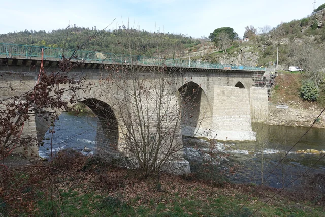
Cavez Bridge over the Tâmega River, with stone arches, a deck and tree-lined banks.
Partial view of the Ponte de Cavez over the Tâmega.© Joseolgonⓘ

Vamos experimentar?

  1. Draw an arc pointed and another semicircular, from the descriptions.
  2. Associate the three central openings and the two sides to the forms indicated in the text.
  3. Note the partial photograph: Mark only the visible arches without completing the frame as if you were seeing them all.

Reading and drawing exercises; schemes do not reproduce the dimensions of the bridge.

Open a história e os seus recursos →
Sources of this proposal

My findings

An idea, a drawing or a question to go on.
PROPOSTA 2 DE 3 · Life you do not always see

Try observing

General biology · aquatic insects, without a local species inventory

Tiny shelters beneath the water

Caddisfly larvae live in water; many build shelters from sand or plant fragments. They form part of river and stream food webs, providing food for fish, birds and amphibians. The Tagis guide highlights their usefulness as ecological indicators. Finding one individual, however, does not certify water quality on its own. The submerged shelter is only part of the story. The adult has hairy wings and slender antennae, and holds its wings like a small roof over its body when resting. It may resemble a butterfly or moth, but those have scales on their wings. Adult caddisflies usually fly around dusk and live near freshwater bodies. There is no single menu for all larvae either: depending on the group, they may eat algae, plants, organic remains or other invertebrates. They are consumers and, at the same time, food for other animals. A food web describes these relationships better than a line assigning just one food to each species.

Vamos experimentar?

  1. Observe the water from an accessible and stable margin.
  2. Look for differences between sand, vegetable remains and small shelters without collecting them.
  3. If you do not distinguish any, save the question for an accompanying activity.

An activity to try at your own pace, without collecting specimens.

Open a história e os seus recursos →
Sources of this proposal

My findings

An idea, a drawing or a question to go on.

PROPOSTA 3 DE 3 · Travel through time

Try observing

Gondiães and Vilar de Cunhas · memory and landscape

A house with three granaries

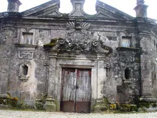
At Casa de Chouzas, three 19th-century granaries stand alongside the manor house highlighted by the municipality. The group connects two functions: living and storing the harvest. Rather than looking only at the main house, it is worth recognising the importance of buildings supporting agriculture. The introduction to Vilar de Cunhas places this heritage in a landscape of plateau and mountain, shaped by farming and pastoralism. House and granaries can be read in that working context, although the source does not detail each property’s production. The house’s dating is less firm: the municipality presents it as perhaps 19th-century, while assigning the granaries to the 19th century. That difference should remain visible. The photograph accompanying the reading shows the portal, not the three granaries. The heritage reference does not confirm access to the group.

Municipal archive photograph: Casa de Chouzas.
Portal da Casa de Chouzas · photo of the municipal inventory; the granaries do not appear in this framework.ⓘ

Vamos experimentar?

  1. Look at the photo of the portal and list only the elements you can see.
  2. Compared to the three granaries mentioned in the text: what depends on the written description?
  3. Imagine a caption that distinguishes the frame of the photograph from the remaining patrimonial set.

An activity to try at your own pace, without collecting specimens.

Open a história e os seus recursos →
Sources of this proposal

My findings

An idea, a drawing or a question to go on.

YOUR LOCAL GUIDE

What would you like to discover?

Take a closer look.