Discover Cabeceiras de BastoFree independent guide
ViveCabeceirasYOUR GUIDE TO CABECEIRAS
ENEnglish
SearchSaved
CHOICE · EXPERIMENTARY · TAKE

Your notebook

Choose up to six ideas, try them and take your discoveries with you.

2 de 6 propostas escolhidas · faça-as ao seu ritmo.

PROPOSTA 1 DE 2 · Travel through time

Try drawing

Reorder or remove

Arco de Baúlhe · archaeological interpretation

Vamos experimentar?

  1. Draw two villages and fields among them.
  2. Use arrow keys to represent the hypothesis of population change; do not draw a historical route as if it were proven.
  3. Compare the history of the Arch with that of the agricultural couple of Abadim.

A paper proposal to explore history at your own pace.

Discover the story

Before the railway, a hillfort

During Romanisation, the region’s settlements did not all follow the same path. The Archaeological Map suggests that the small hillfort at Arco de Baúlhe may have lost inhabitants while Chacim became more central. It also mentions the expansion of agricultural occupation onto lower land. This interpretation helps us imagine a changing territory, but gives no certain date for the abandonment of Arco’s hillfort. The Map places these changes within a process beginning in the second half of the 1st century BC. Transformation extended beyond houses: relationships among settlements, fields and centres of power changed too. Chacim appears as a focus for population and renewed spaces, while Arco is presented as a possible example of depopulation. Material from Mó de Cima, in Chacim, is used to support the agricultural occupation of lower land. Later, the text highlights open farmstead-type settlements such as Abadim. Read together, these clues show a change in territorial organisation; they do not allow a single movement of inhabitants between two points to be traced, or every change to be dated to the same year.

Open a história e os seus recursos →
Sources of this proposal

My findings

An idea, a drawing or a question to go on.
PROPOSTA 2 DE 2 · Travel through time

Comparing arc shapes

Reorder or remove

History of Cavez Bridge

Vamos experimentar?

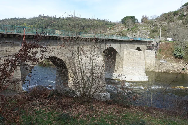
  1. Draw an arc pointed and another semicircular, from the descriptions.
  2. Associate the three central openings and the two sides to the forms indicated in the text.
  3. Note the partial photograph: Mark only the visible arches without completing the frame as if you were seeing them all.

Reading and drawing exercises; schemes do not reproduce the dimensions of the bridge.

Discover the story

Five arches, more than one era

Three central pointed arches and two round arches beside the banks: the Bridge of Cavez brings together different forms and periods. The Museum dates the medieval construction to the second half of the 13th century, serving the road between Braga and Vila Pouca de Aguiar. The source attributes the round arches to work during Philip II’s reign and mentions a marker from 1599. In the 19th century, the road between Fafe and Vila Pouca de Aguiar brought a widening of the deck. Looking at the bridge means seeking the changes in an old crossing. According to the Museum, the stone bridge replaced an earlier wooden one that had deteriorated. Construction is attributed to Frei Lourenço Mendes, a Dominican who collected alms for the work; the museum text mentions testamentary bequests supporting that connection. The crossing thus involves materials, routes and ways to fund a shared undertaking.

Cavez Bridge over the Tâmega River, with stone arches, a deck and tree-lined banks.
Partial view of the Ponte de Cavez over the Tâmega.© Joseolgonⓘ
Open a história e os seus recursos →
Sources of this proposal

My findings

An idea, a drawing or a question to go on.

YOUR LOCAL GUIDE

What would you like to discover?

Take a closer look.