Discover Cabeceiras de BastoFree independent guide
ViveCabeceirasYOUR GUIDE TO CABECEIRAS
ENEnglish
SearchSaved
9 STORIES · CONTINUOUS READING

St Nicholas: water, houses and paths

Nine stories between water, houses and collective life of São Nicolau. From the bridges and mills described in 1758 to the use of water in Covas, compares documents from different times. It continues by architecture, by the old school and by the memory that dances.

All stories in the order of the route. You can print this page by the browser; sources and credits follow the reading.

Things to try5 activities · 3 interactive explorations · 1 question
Environmental history · account from 1758

A landscape described in 1758

Heathers, carqueja, oaks and animals in the parish priest’s words.

The account from São Nicolau describes differences between hills: some covered in heather and carqueja, others in gorse and oaks. It also mentions rabbits, partridges, hares, wolves, wild boar and foxes. This testimony shows how nature was described in the 18th century; it is not a current species inventory. The author also compares the terrain, distinguishing finer-grained stones to the north and east from large boulders to the west and south.

Getting to know the parish
Source and context

Municipality — Parish memories of St Nicholas, 22/05/1758
Accessed:

Basto Land Museum — St Nicholas Parish Memories, 22 May 1758
Accessed:

Editorial summary; the date of consultation is not the date of the facts.

Back to index ↑
Saint Nicholas · rivers in 1758

Bridges put to the winter test

Crossing the river was part of everyday life.

The São Nicolau account of 1758 describes three wooden bridges. It says that winter waters sometimes covered the two higher ones and even swept some bridges away. This is historical testimony about floods and routes, not a way to assess the safety of today’s crossings. The document names Sendim, Cerdeiró and Ponte do Gado: these crossings helped connect the church with settlements in the parish.

The description goes beyond the force of floods. It mentions a watercourse with many falls, difficult to ford and, in some stretches, even difficult to follow along its banks. The bridges answered that challenge of the terrain.

The Sendim bridge lay on the route from the church to that settlement; the Cerdeiró bridge served the direction of Breia. Ponte do Gado was lower than the other two and gave its name to the point where the branches from Bucos entered. These details connect paths with waterways without fixing every structure’s position on a modern map.

Cross, sail or water?

Open an option and choose the story.

  1. Rio Douro: many uses, no boatsIn summer, the water took other paths →
  2. Santa Senhorinha: a quiet chainThe river entered the life of the fields →
  3. Vilarinho: loaded car ticketA bridge for loaded cars →
Compares the descriptions of three parishes in the answers of 1758. The form of the river conditioned different uses.
Getting to know the parish
Source and context

Basto Land Museum — St Nicholas Parish Memories (1758)

Accessed: . Editorial summary; the date of consultation is not the date of the facts.

Back to index ↑
São Nicolau · 1758 account

Water irrigated fields and made olive oil

One river, different kinds of work.

In 1758, the parish priest of São Nicolau described irrigation channels serving fields and water powering an olive-oil mill at Quinta da Taipa. One channel served Gondarém, Frágua, Penedo and Lamelas. The account helps us imagine the link between river, irrigation and production. It distinguishes three continuous channels: one for those settlements and two for the estates of Bouças and Taipa. It also mentions mills supplied by weirs.

The description includes a smaller watercourse to the west, originating in springs on the hills of Lapela and Celeiró. On this river, the rector mentions mills and a channel serving the fields of Casal. He recalls two others intended for Quinta da Taipa, one of them ruined. The water-use network therefore included structures in use and others that no longer worked as before.

This detail helps us understand water-powered heritage as ongoing work: a channel’s existence in an old account does not guarantee its use in another period. The source also distinguishes settlements’ shared uses from estate channels, allowing comparison of different relationships between water, fields and owners.

Getting to know the parish
Source and context

Basto Land Museum — St Nicholas Parish Memories (1758)

Accessed: . Editorial summary; the date of consultation is not the date of the facts.

Back to index ↑
Saint Nicholas · hydraulic heritage inventoryed in 2008

A hollowed log channelled the water’s power

At Quinta de Covas, olive oil’s history meets the story of energy.

The inventory of 27 February 2008 places the Quinta de Covas mill at Parada, in Cabeceiras de Basto parish. Water came from a channel with a weir on the Peio. Before reaching the horizontal waterwheel, it passed along a trough hollowed from a tree trunk: wood also formed part of this water-powered structure.

The building combined an olive-oil mill, a grain mill and a wine press. The record associates the closure of the grain and olive-oil mills in 1994 with a hydroelectric plant coming into operation and affecting the available motive power. This is the explanation recorded in that survey, not an independent assessment of the plant’s operation.

The document describes private heritage and equipment already lacking the parts needed for grinding. This story indicates neither public access nor present conservation conditions.

Water changes work

Open an option and choose the story.

  1. In Ramil, water passes through graniteFrom Petimão to olive oil press →
  2. Peio also feeds millsPeio also made flour →
  3. How water can produce electricityWater also reaches the light and fields →
Compare documented buildings with a general explanation of electricity production.
Source and context

Municipality — inventory of olive oil mills, record L.A.5, withdrawal of 27/02/2008

Accessed: . Editorial summary; the date of consultation is not the date of the facts.

Back to index ↑
Built heritage · São Nicolau

Three houses, three details

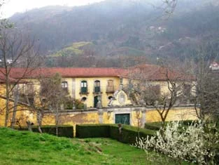
Municipal archive photograph: Casa da Breia.
Overview of Casa da Breia · municipal inventory photographⓘ

A chapel, a staircase and a gateway help us read architecture.

Three houses, three details to notice. At Casa da Taipa, the municipal introduction highlights the chapel of Nossa Senhora da Conceição, with its 16th-century design. At Casa da Breia, it describes the staircase with scrolls in the stone handrail, retaining uncertainty over the building’s attribution to the 18th century.

At Casal da Fonte, attention turns to the portal with its coat of arms and late-18th-century Baroque decoration. Comparing chapel, staircase and portal reveals different ways of composing a manor house. These references do not imply access to the properties’ interiors.

Getting to know the parish See Fact sheet: Casa da Breia See Fact sheet: Casa da Taipa e Capela da Senhora da Conceição
Source and context

Municipality — Cabeceiras de Basto (São Nicolau)

Accessed: . Editorial summary; the date of consultation is not the date of the facts.

Back to index ↑
São Nicolau · interior described in 1758

Five altars, many stories

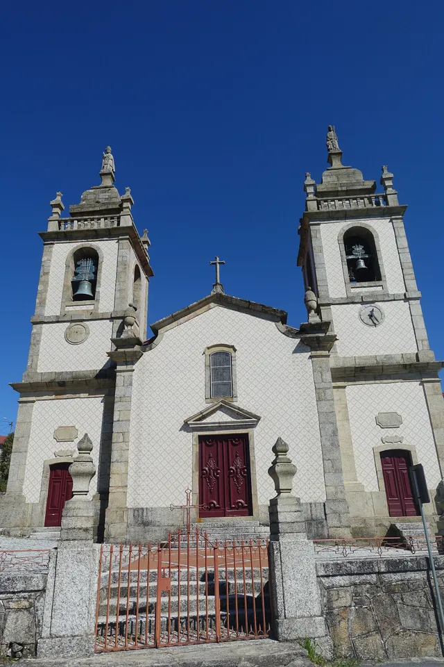
Façade of the Church of São Nicolau de Cabeceiras, with two bell towers, tiles and statues along the top.
Place linked to this story: Igreja de São Nicolau de Cabeceiras© Joseolgonⓘ

The 1758 account offers a look inside the church.

Rector Domingos Camelo de Sousa described five altars in the church of São Nicolau. At the high altar, he placed Saint Nicholas and Saint Blaise on opposite sides, with Christ Crucified in the centre, within a gilded carved-wood setting.

The other altars were dedicated to Our Lady of the Rosary, the Lord of the Steps of the Passion, Saint Sebastian and the Souls in Purgatory. This is a portrait written in 1758, not confirmation of the current arrangement.

See Fact sheet: Igreja de São Nicolau de Cabeceiras
Source and context

Basto Land Museum — St Nicholas Parish Memories (1758)

Accessed: . Editorial summary; the date of consultation is not the date of the facts.

Back to index ↑
São Nicolau · 1758 account

When a chapel shortened the journey

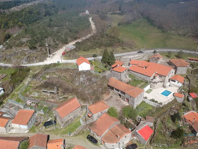
Aerial view of Busteliberne’s houses and the surrounding hillside
Place linked to this story: Busteliberne© Joseolgonⓘ

Distance from the church also shaped villages.

The 1758 account explains the function of three chapels: São Bartolomeu at Celeiró do Monte, Nossa Senhora da Lapa at Lapela and Santa Ana at Busteliberne. They administered sacraments to residents living far from the parish church. A small building answered an everyday difficulty.

Rector Domingos Camelo de Sousa describes high hills between settlements and mentions three villages half a league from the church over rough terrain. Distance was more than a line on a map: relief formed part of the difficulty. The church stood to the east in a place with six households, including the rector’s own house.

According to the account, the three chapels were maintained at the commander’s expense. They were not the only ones, however: the text lists eleven chapels besides the parish church, with different administrations and functions. At Outeiro de Santo António, for example, it notes pilgrimages from neighbouring parishes during the feasts of Santo António and Santa Luzia. The group reveals both worship close to residents and gatherings that attracted people from outside.

Three Ways to Approach Places

Open an option and choose the story.

  1. Closest chapel in Casares

    Also in Bucos distance to the church helps explain a chapel.

    A chapel shortened the distance →
  2. Move from one margin to another

    The bridges add another dimension to the history of travel.

    Bridges winter tested →
  3. Know the matrix inside

    The account describes the altars of the church serving the parish.

    Five altars, many stories →
Compare needs and solutions described in historical sources.
Getting to know the parish See Fact sheet: Busteliberne See Fact sheet: Igreja de São Nicolau de Cabeceiras
Source and context

Basto Land Museum — St Nicholas Parish Memories (1758)

Accessed: . Editorial summary; the date of consultation is not the date of the facts.

Back to index ↑
São Nicolau · Celeirô do Monte, reuse reported in 2016

The school brought the village together again

In Celeirô do Monte, a school building found another use.

A municipal report from January 2016 recounts how Celeirô do Monte’s former primary school, closed for about eight years, returned to serving the community in 2015. Made available to the parish council for community activities, it received improvements to the floor and entrance. At the end of that year, the village gathered there to welcome 2016. The story shows a building being reused; it does not confirm its current operation or access.

Source and context

Municipality — Mayor visited parish of Cabeceiras de Basto: former Primary School of Celeirô do Monte, 11/01/2016

Accessed: . Editorial summary; the date of consultation is not the date of the facts.

Back to index ↑
São Nicolau · association memory and folklore

A memory you can dance

São Nicolau’s associations have a story linked to folklore.

The municipal directory gives 2002 as the founding year of the Associação Grupo Folclórico de S. Nicolau and locates it in Cumieira. The introduction highlights participation in festivals, celebrations and pilgrimages as a way to share Basto’s folklore and ethnography. Dance adds a collective dimension to the parish’s memory, without this reference announcing current performances or rehearsals.

Source and context

Municipality of Cabeceiras de Basto — Associativism: Culture and Entertainment, presentations by the Eagles of Painzela and the Folkloric Group of St. Nicholas

Accessed: . Editorial summary; the date of consultation is not the date of the facts.

Back to index ↑
YOUR LOCAL GUIDE

What would you like to discover?

Take a closer look.