Discover Cabeceiras de BastoFree independent guide
ViveCabeceirasYOUR GUIDE TO CABECEIRAS
ENEnglish
SearchSaved
CHOICE · EXPERIMENTARY · TAKE

A notebook.
Your findings.

Up to six proposals of Cabeceiras, in your own order, to do it at home, in company or on a break.

2 de 6 propostas escolhidas · faça-as ao seu ritmo.

PROPOSTA 1 DE 2 · Travel through time

Try observing

Gondiães and Vilar de Cunhas · memory and landscape

A house with three granaries

At Casa de Chouzas, three 19th-century granaries stand alongside the manor house highlighted by the municipality. The group connects two functions: living and storing the harvest. Rather than looking only at the main house, it is worth recognising the importance of buildings supporting agriculture. The introduction to Vilar de Cunhas places this heritage in a landscape of plateau and mountain, shaped by farming and pastoralism. House and granaries can be read in that working context, although the source does not detail each property’s production. The house’s dating is less firm: the municipality presents it as perhaps 19th-century, while assigning the granaries to the 19th century. That difference should remain visible. The photograph accompanying the reading shows the portal, not the three granaries. The heritage reference does not confirm access to the group.
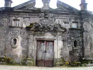
Municipal archive photograph: Casa de Chouzas.
Portal da Casa de Chouzas · photo of the municipal inventory; the granaries do not appear in this framework.ⓘ

Vamos experimentar?

  1. Look at the photo of the portal and list only the elements you can see.
  2. Compared to the three granaries mentioned in the text: what depends on the written description?
  3. Imagine a caption that distinguishes the frame of the photograph from the remaining patrimonial set.

An activity to try at your own pace, without collecting specimens.

Open a história e os seus recursos →
Sources of this proposal

My findings

An idea, a drawing or a question to go on.

PROPOSTA 2 DE 2 · Between rivers and mountains

Sits the municipality in four directions

Geographical framework

The Tâmega traces the boundary

The Tâmega follows much of Cabeceiras’s southern and south-eastern boundary. To the east, the municipality’s geographical introduction mentions the River Bessa. Water therefore helps locate the territory, alongside the mountains to the north and west. The neighbouring municipalities to the south are Celorico de Basto and Mondim de Basto; Ribeira de Pena lies to the east. These references offer a starting point for reading the map before moving on to bridges, fields and the tributary network. Complete the picture by looking to the other sides: Montalegre and Boticas to the north, Vieira do Minho to the north-west and Fafe to the west. Cabreira and Barroso frame the north; the Serra da Lameira frames the west. Administrative boundaries and the water network are two different ways to read the same territory: follow the tributaries next to see where the water goes.

Vamos experimentar?

  1. Draws a rose from the simple winds, with north, south, spring and west.
  2. Places the Tâmega south and southeast, the Bessa the spring and the mountains on the sides indicated by the text.
  3. Opens the river network and compares: what are the boundaries of the territory and what are water connections?

An activity to try at your own pace, without collecting specimens.

Open a história e os seus recursos →
Sources of this proposal

My findings

An idea, a drawing or a question to go on.

YOUR LOCAL GUIDE

What would you like to discover?

Take a closer look.