Discover Cabeceiras de BastoFree independent guide
ViveCabeceirasYOUR GUIDE TO CABECEIRAS
ENEnglish
SearchSaved
CHOICE · EXPERIMENTARY · TAKE

A notebook.
Your findings.

Up to six proposals of Cabeceiras, in your own order, to do it at home, in company or on a break.

2 de 6 propostas escolhidas · faça-as ao seu ritmo.

PROPOSTA 1 DE 2 · Travel through time

Try observing

Gondiães and Vilar de Cunhas · memory and landscape

A house with three granaries

At Casa de Chouzas, three 19th-century granaries stand alongside the manor house highlighted by the municipality. The group connects two functions: living and storing the harvest. Rather than looking only at the main house, it is worth recognising the importance of buildings supporting agriculture. The introduction to Vilar de Cunhas places this heritage in a landscape of plateau and mountain, shaped by farming and pastoralism. House and granaries can be read in that working context, although the source does not detail each property’s production. The house’s dating is less firm: the municipality presents it as perhaps 19th-century, while assigning the granaries to the 19th century. That difference should remain visible. The photograph accompanying the reading shows the portal, not the three granaries. The heritage reference does not confirm access to the group.

Vamos experimentar?

  1. Look at the photo of the portal and list only the elements you can see.
  2. Compared to the three granaries mentioned in the text: what depends on the written description?
  3. Imagine a caption that distinguishes the frame of the photograph from the remaining patrimonial set.

An activity to try at your own pace, without collecting specimens.

Open a história e os seus recursos →
Sources of this proposal

My findings

An idea, a drawing or a question to go on.
PROPOSTA 2 DE 2 · Between rivers and mountains

Try observing

Landscape · Abadim

Follow the water’s path

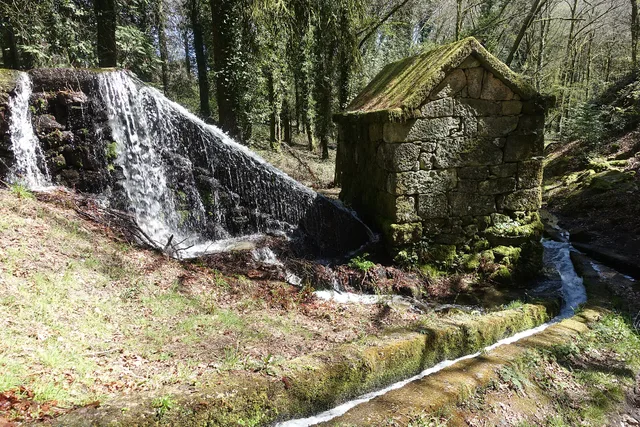
The Levada de Víbora connects the water’s path with the work of milling. The municipal description of PR1 CBC links its start beside the Oural dam in Abadim to the Moinhos de Rei, woodland and small waterways. It also highlights the village and viewpoint of Porto d’Olho and the Víbora leisure park. The destination is only part of the appeal: the channel helps explain how water was directed and used. To choose the walk, consult the trail profile and compare distance and difficulty; this story does not replace up-to-date information about the route’s condition.

Granite mill supplied by the Levada de Víbora at Moinhos de Rei, with a waterfall and channel in wooded surroundings. Photograph from 2025.
A mill and the water channel at Moinhos de Rei.© Joseolgonⓘ

Vamos experimentar?

  1. Before leaving, compare the track record with another walk available on the site.
  2. If you walk the path, observe from a safe point the relationship between the channel and the relief, without leaving the route.
  3. In a later design, it distinguishes the water that flows naturally from the water that is driven by the lead.

An activity to try at your own pace, without collecting specimens.

Open a história e os seus recursos →
Sources of this proposal

My findings

An idea, a drawing or a question to go on.

YOUR LOCAL GUIDE

What would you like to discover?

Take a closer look.